Saint Lawrence Seaway
Binational system of canals, locks and channels linking the Atlantic Ocean to the Great Lakes, enabling oceangoing vessels to reach major North American industrial ports.
Overview
The Saint Lawrence Seaway is a managed navigation system that links the Atlantic Ocean to the Great Lakes, allowing oceangoing ships and smaller vessels to travel inland to ports on Lakes Ontario, Erie and beyond. Stretching roughly 370 miles (about 600 km) from the Gulf of Saint Lawrence and the lower Saint Lawrence River inland to the western end of Lake Ontario and through the Welland Canal, the Seaway opened a continuous water route for commercial trade and passenger navigation between the Atlantic and North America's industrial heartland.
Image gallery
10 Images


Design and main features
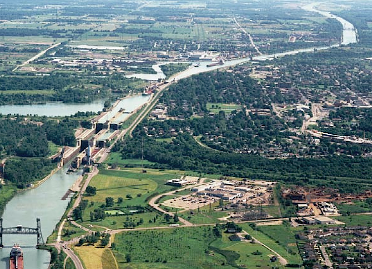
The system is a mix of natural channels, engineered canals and locks that change elevations to permit vessels to bypass rapids, dams and waterfalls. The completed Seaway includes 15 locks along its navigation route and major improvements to the Welland Canal, which allows ships to transit between Lake Ontario and Lake Erie without passing Niagara Falls. Vessels that use the system are constrained by a size standard commonly known as "Seawaymax," which defines the maximum dimensions that can pass through the locks.
History and construction
Plans for an improved Saint Lawrence route date back to the 19th and early 20th centuries, but a large binational construction program began in the 1950s when Canada and the United States agreed to build a modern seaway and related hydroelectric works. Construction started in 1954 and the completed navigation system opened in 1959. The project involved extensive engineering work, new canal channels and lock complexes, and cost hundreds of millions of dollars in mid‑century currency. Its creation required cooperation between national, provincial/state and local authorities and led to the relocation of some communities and changes in shoreline infrastructure.
Economic role and uses
The Seaway carries bulk cargoes—such as grain, iron ore, coal, and petroleum products—as well as general goods and some containerized freight. At peak seasons, it handles tens of millions of tonnes of cargo annually and serves as a vital trade artery for cities on and near the Great Lakes, supporting industrial and port facilities in Toronto, Hamilton, Buffalo, Cleveland, Detroit, Milwaukee, Chicago and other communities. Both commercial shipping lines and recreational craft use portions of the route, though oceangoing vessels must obey lock schedules and size restrictions.
Operations, governance and notable issues
The Seaway is operated under a binational arrangement. Canadian and U.S. agencies share responsibility for navigation, safety and maintenance; in Canada this includes a federal corporation, and the United States manages its portion through a public agency. Over the decades the Seaway has faced operational challenges and environmental concerns, including the spread of non‑native aquatic species through ballast water and changes in cargo patterns caused by shifts in industry and transport economics. Proposals to modify or expand some sections to accommodate larger container ships have been discussed, but physical, environmental and economic constraints shape what changes are viable.
Notable distinctions
- The Seaway made the Great Lakes a direct outlet for international maritime trade, rather than relying solely on transshipment at coastal ports.
- Because it crosses an international boundary, it is a model of cross‑border infrastructure planning and joint operation.
- Its lock size defines a class of ship (Seawaymax) similar in concept to size limits for the Panama and Suez canals.
Further reading and resources
- Resource 1: Overview and map
- Resource 2: Geographic context
- Resource 3: Atlantic approaches
- Resource 4: Great Lakes connections
- Resource 5: Canadian sections
- Resource 6: U.S. sections
- Resource 7: Saint Lawrence River
- Resource 8: Lake Ontario access
- Resource 9: Gulf of Saint Lawrence
- Resource 10: Small craft navigation
- Resource 11: Commercial shipping
- Resource 12: Rapids and natural barriers
- Resource 13: Dams and hydroelectric works
- Resource 14: Niagara and regional obstacles
- Resource 15: Waterfalls and navigation history
- Resource 16: Lake Erie connections
- Resource 17: Early planning and proposals
- Resource 18: Government agreements
- Resource 19: Urban impacts
- Resource 20: Economic background
- Resource 21: Construction start (1954)
- Resource 22: Canal engineering
- Resource 23: Montreal terminal
- Resource 24: Locks and lift mechanisms
- Resource 25: Water levels and control
- Resource 26: Power generation sites
- Resource 27: Hydroelectric context
- Resource 28: Opening year (1959)
- Resource 29: Project costs and funding
- Resource 30: Recreational boating
- Resource 31: Passenger and cruise traffic
- Resource 32: Cargo statistics
- Resource 33: Overseas trade routes
- Resource 34: Middle East trade links
- Resource 35: African connections
- Resource 36: Regional economic effects
- Resource 37: Toronto port facilities
- Resource 38: Hamilton and steel industry
- Resource 39: Buffalo and cross‑border trade
- Resource 40: Cleveland and manufacturing
- Resource 41: Detroit and automotive supply
- Resource 42: Milwaukee and regional ports
- Resource 43: Chicago and inland connections
- Resource 44: Container ship considerations
- Resource 45: Comparative canal dimensions
Related articles
Author
AlegsaOnline.com Saint Lawrence Seaway Leandro Alegsa
URL: https://en.alegsaonline.com/art/85811