Gulf of Saint Lawrence
Semi‑enclosed sea where the Great Lakes and Saint Lawrence River discharge into the Atlantic; a vast estuary along eastern Canada supporting fisheries, shipping, marine life and coastal communities.
Overview
The Gulf of Saint Lawrence is the broad marine basin that receives the freshwater outflow of North America's Great Lakes through the Saint Lawrence River and connects it to the Atlantic Ocean. It forms a semi‑enclosed sea bounded by the island of Newfoundland, the Labrador coast, the provinces of Quebec, New Brunswick and Prince Edward Island, and several smaller islands. Its geographic position is often cited with map coordinates. The gulf covers a large area and is commonly described as the world's largest estuary (estuary), with a substantial volume of brackish water influenced by river discharge, tides and ocean currents.
Image gallery
10 Images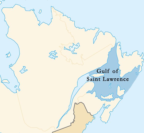


Physical characteristics
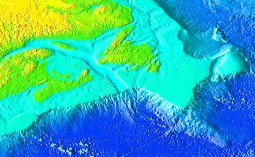
The gulf displays a gradient from fresher, nutrient‑rich waters near the river mouth to saltier oceanic waters toward the Atlantic. Depths vary: broad shallow shelves give way to deeper channels that link to offshore waters. Ice forms seasonally over much of the gulf in winter, affecting navigation and the timing of biological events. Bathymetry and currents shape habitats for fish, plankton and marine mammals.
Bordering lands and islands
- Canadian provinces along the gulf include Quebec, Newfoundland and Labrador, New Brunswick, Nova Scotia and Prince Edward Island.
- Notable islands and features include Anticosti Island and the French territorial archipelago of Saint Pierre and Miquelon.
- Connections: the gulf links the Great Lakes system via the Saint Lawrence River to the wider Atlantic Ocean.
History and development
The gulf's present form results from glacial and post‑glacial processes that shaped coastlines and submerged river valleys. For centuries it has been a corridor for Indigenous peoples, European explorers, coastal fisheries and later commercial shipping. The navigable passages into the Saint Lawrence River became crucial for access to interior North America and continue to support major ports, the seaway system and coastal communities.
Ecology and human uses
Biologically, the gulf supports rich fisheries (groundfish, shellfish and pelagic species), feeding grounds for migratory birds and important habitat for whales and seals. Human uses include commercial and recreational fishing, shipping and tourism. Environmental issues such as overfishing, habitat change, shipping impacts and seasonal ice variability are ongoing management concerns for governments, local communities and Indigenous groups.
Notable facts and distinctions
The Gulf of Saint Lawrence is commonly described as a semi‑enclosed sea and an extensive estuarine zone because of the mixing of large river discharge with ocean water, which creates distinctive physical and ecological conditions. It remains a region of economic importance and cultural significance for the provinces and territories that border it, and for France through its small dependency in the gulf.
Questions and answers
Q: Where are the coordinates of the Gulf of Saint Lawrence?
A: The coordinates of the Gulf of Saint Lawrence are 48°0′N 61°30′W / 48.000°N 61.500°W / 48.000; -61.500.
Q: What is the Gulf of Saint Lawrence?
A: The Gulf of Saint Lawrence is the outlet of North America's Great Lakes via the Saint Lawrence River into the Atlantic Ocean. It is the world's largest estuary.
Q: How big is the Gulf of Saint Lawrence?
A: The Gulf of Saint Lawrence is a semi-enclosed sea, covering an area of about 236,000 km2 (91,000 sq mi) and having 35,000 km3 (7.7×10¹⁵ imp gal) of water.
Q: What is an estuary?
A: An estuary is a partially enclosed coastal body of brackish water with one or more rivers or streams flowing into it, and with a free connection to the open sea.
Q: What is the significance of the Gulf of Saint Lawrence?
A: The Gulf of Saint Lawrence is significant because it is the outlet for North America's Great Lakes into the Atlantic Ocean and is the world's largest estuary.
Q: What type of sea is the Gulf of Saint Lawrence?
A: The Gulf of Saint Lawrence is a semi-enclosed sea.
Q: How much water does the Gulf of Saint Lawrence have?
A: The Gulf of Saint Lawrence has 35,000 km3 (7.7×10¹⁵ imp gal) of water.
Related articles
Author
AlegsaOnline.com Gulf of Saint Lawrence Leandro Alegsa
URL: https://en.alegsaonline.com/art/41377
Sources
- tourismeilesdelamadeleine.com : "Parks Reserves and Natural Sites"