Montreal
![]()
This article is about the Canadian city. For other meanings, see Montreal (disambiguation).
Montreal (German [mɔntʁeˈa:l]) or Montréal (French [mɔ̃ʁeˈal], English [ˌmʌntɹiːˈɒl]) is a city of one million inhabitants in Canada. It is located in the southwest of the province of Quebec on Île de Montréal, the largest island in the High Elaga Archipelago, which is flowed around by the Saint Lawrence River and estuaries of the Ottawa. The neighbouring province of Ontario lies just under 60 kilometres to the west, the border with the USA just over 50 kilometres to the south. The cityscape is dominated by Mont Royal, a 233-metre-high range of hills of volcanic origin in the centre of the island, from which the city derives its name.
When the French navigator Jacques Cartier was the first European to explore the area in 1535, Saint Lawrence Iroquois lived on the island. In 1642, Paul Chomedey de Maisonneuve and Jeanne Mance founded Fort Ville-Marie, a Catholic mission station. This subsequently developed into the settlement of Montreal, which came under British rule in 1760. Montreal received its city charter in 1832. The city grew rapidly and developed into the economic and cultural centre of the country, but lost this leading role to Toronto in the last quarter of the 20th century. Significant events of global impact were the World Expo 67 and the 1976 Summer Olympics.
Montreal's economy is highly diversified. Important pillars of the service sector are financial services, media, trade and design. Tourism is also of great importance, due to the sights and the diverse cultural offerings, which include not only museums but also numerous festivals in the areas of film, theater and music. More than 60 international organizations have their headquarters in Montreal. The industrial sector is dominated by aeronautics, pharmaceuticals and high-tech companies. With four universities and several other colleges, Montreal is a major educational hub. The city is also a hub in the rail and road network and also has the largest inland port on the American continent.
With a population of 1,704,694 inhabitants (as of 2016), Montreal is the second largest city in Canada after Toronto and the largest in the province of Québec. The administrative region, which includes all municipalities on the island, has a population of 1,942,044 (as of 2016). The metropolitan area Communauté métropolitaine de Montréal, which includes urban areas in the immediate vicinity, has a population of 4,098,927 (as of 2016). French is Montreal's official language and the primary language of 56.9% of the population, while 18.6% speak primarily English. The remainder is made up of various immigrant languages, giving Montreal a multicultural population.
Montreal is the second largest city in the world after Paris where French is spoken as a native language. Montreal is also one of the largest cities in the world where French is the official language. The city used to be second to Paris, but has given up that rank to Kinshasa and Abidjan in recent years.
Geography
Location
Montreal is located in the southwest of the province of Québec, just under 60 kilometres east of the neighbouring province of Ontario and just over 50 kilometres north of the border with the USA. The provincial capital of Québec is 233 kilometres away in the northeast, the federal capital Ottawa 166 kilometres away in the west. It is 504 kilometres to Toronto in a southwesterly direction, 404 kilometres to Boston in a southeasterly direction and 533 kilometres to New York in a southerly direction.
Topography and geology
Most of the city is located on Île de Montréal, by far the largest island in the High Elaga archipelago. The 499 km² island, which is roughly shaped like a boomerang, is 50 kilometres long and up to 16 kilometres wide. On its southern and eastern sides, Île de Montréal is flowed around by the Saint Lawrence River (Fleuve Saint-Laurent), one of the most powerful rivers in North America. The western and northern boundaries are formed by the Rivière des Prairies, one of three estuaries of the Ottawa (fr. Rivière des Outaouais). The major rivers widen into lakes at two points, the Ottawa to the west to form Lac des Deux Montagnes, and the St Lawrence to the south to form Lac Saint-Louis. Another major waterway is the 14.5-kilometre Lachine Canal in the south of the island, built to bypass the Lachine Rapids. The Saint Lawrence Seaway, which made the Lachine Canal redundant in 1959, extends along the Saint Lawrence River just outside the city limits.
A small part of the urban area extends over several offshore islands. The most important are Île Sainte-Hélène, Île Notre-Dame and Île des Sœurs to the east and Île Bizard to the west. Just outside the city limits are Île Jésus to the northwest and Île Sainte-Thérèse and Îles de Boucherville to the northeast, among others. Montreal has no territories on the mainland.
In the center of the otherwise mostly flat Île de Montréal rises Mont Royal, a range of hills composed of volcanic gabbroic rock with three peaks at elevations of 233, 211, and 201 meters. The westernmost of the Montérégie hills was formed in the Cretaceous period about 125 million years ago by intrusion of igneous rocks and hornfels. Through erosion, the surrounding layers of sedimentary rocks, up to two kilometres thick, were eroded over millions of years. To the west and north of Mont Royal, thick layers of limestone were deposited at the bottom of primordial oceans. These were quarried in numerous quarries until well into the 20th century and were mainly used for building houses. Otherwise, boulder clay predominates, which was deposited by advancing and retreating glaciers during the Wisconsin Glaciation. During the final stages of the Glaciation, some 13,000 to 10,000 years ago, the Saint Lawrence Valley was below sea level in the Sea of Champlain. This shallow inlet of the Atlantic Ocean gradually disappeared due to postglacial land uplift.
Neighboring communities
More than three quarters of the urban area is surrounded by water. Neighbouring municipalities to the southwest of Île de Montréal are Dollard-Des Ormeaux, Dorval, Kirkland, Sainte-Anne-de-Bellevue and Senneville. There are six enclaves within the urban area. These are the municipalities of Côte-Saint-Luc, Hampstead, Montréal-Est, Montréal-Ouest, Mont-Royal and Westmount.
To the northwest, on the other side of the Rivière des Prairies on Île Jésus, lies the town of Laval, and to the north the commune of Charlemagne. To the west of Île Bizard, on the opposite shore of Lac des Deux Montagnes, are Deux-Montagnes, Sainte-Marthe-sur-le-Lac and Pointe-Calumet. To the east and south, along the Saint Lawrence River, are the following municipalities: Varennes, Boucherville, Longueuil, Saint-Lambert, Brossard, La Prairie, Candiac, Sainte-Catherine and Kahnawake (a Mohawk reservation).
Climate
Montreal is located in the transitional area of different climatic regions. Typically, the climate is described as boreal and humid, which corresponds to the effective climate classification Dfb. Summers are short and hot and humid with an average maximum temperature of 26 °C. Temperatures can also rise well above 30 °C on some days, with relatively high humidity prevailing throughout. Winter is characterized by very cold, snowy and windy weather, with prolonged periods of frost to below -20 ° C. Spring and autumn are mild, but there can be large fluctuations in temperature. Montreal and the surrounding area are known for the Indian Summer, which is especially expressed on warm, sunny autumn days with frosty nights.
The annual precipitation amounts to about 980 mm. Snowfall averages about 220 cm from November to April, with 33 days of snow cover exceeding 20 cm. Thunderstorms can occur from late spring to early autumn, and foothills of tropical storms bring heavy rainfall. Sunshine duration is over 2000 hours annually. The lowest temperature ever measured was -37.8 °C on 15 January 1957, the highest 37.6 °C on 1 August 1976. The largest amount of rain in one day was 94 mm on 8 November 1996, the largest amount of new snow 102 cm on 12 March 1971.
| Montreal, 1981-2010 | ||||||||||||||||||||||||||||||||||||||||||||||||
| Climate diagram | ||||||||||||||||||||||||||||||||||||||||||||||||
| ||||||||||||||||||||||||||||||||||||||||||||||||
| Monthly average temperatures and precipitation for Montreal, 1981-2010
Source: Normales climatiques au Canada de 1981à 2010: Aéroport international Pierre-Elliott-Trudeau de Montréal. | |||||||||||||||||||||||||||||||||||||||||||||||||||||||||||||||||||||||||||||||||||||||||||||||||||||||||||||||||||||||||||||||||||||||||||||||||||||||||||||||||||||||||||||||||||||||||||||||||||||||||||||||||||||||||||||||||||||||||||||||||||||||||||||||||||||||||||
fauna and flora
There are numerous green spaces in the city, particularly in the waterfront areas, on Île Bizard and on Mont Royal. They have a significant tree population, mainly deciduous forest. The most common are Norway maples, silver maples, sugar maples, American lime trees, winter lime trees, gleditschias, red ash trees, white ash trees, Siberian elms and hackberry trees. Since 1948, the town has had its own nursery for raising young trees and shrubs that are later planted in the parks and streets. It is located in L'Assomption, about 30 kilometres north of the city centre.
Several species of animals have adapted to living in urban environments and harsh winters. The most common species include raccoons, striped skunks, gray squirrels, and woodchucks. In addition, red foxes and coyotes are increasingly observed.
Montreal's 17 most important green spaces are grouped together under the name Grands parcs de Montréal. They include parks and nature reserves that together cover almost 1800 hectares. In addition, there are dozens of smaller parks and green spaces managed by the municipalities. An important nature reserve just outside the city area is the Parc national des Îles-de-Boucherville on the archipelago of the same name in the St. Lawrence River.
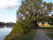
Park at the Rivière des Prairies
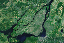
Satellite photo of the Hochelaga archipelago
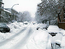
Snow-covered street in the district of Le Plateau-Mont-Royal
History
Origin of the name
The name of the city of Montreal is derived from Mont Royal (French: "royal mountain"). It was named after Jacques Cartier, who discovered the distinctive range of hills on the island in 1535 and named it in honour of King François I. When the Venetian cartographer Giacomo Gastaldi made a map based on Cartier's notes in 1556 for the book series Navigationi et Viaggi published by Giovan Battista Ramusio, he gave the hill range the name Monte Real. François de Belleforest, in La Cosmographie universelle de tout le monde, his cosmography published in 1575, was the first to use the derived name Montréal. After the appearance of a map made by Samuel de Champlain in 1612, the name was transferred to the entire island. The first French settlement on the island, founded in 1642, was called Ville-Marie. This name was gradually supplanted by Montréal and fell out of use in the first half of the 18th century.
After the end of French rule in 1760, the city retained its name, but the English spelling does not use an acute. The city's inhabitants are called Montrealers in English, Montréalais (masculine) or Montréalaises (feminine) in French, although the form Montréalistes was originally common. In Iroquoian languages, the city is called Tiohtià:ke, and in Algonquian languages, Moniang. The original city name is now used for the central district of Ville-Marie.
Early history and discovery
The earliest evidence of human presence in the territory of what is now the province of Québec dates back some ten millennia. As early as around 5000 BC, the focal points of cultural development can be traced to the Great Lakes and the Saint Lawrence River (Proto-Laurentian). From this, a wide-ranging regional culture developed, which is referred to as the Middle Great Lakes-St. Lawrence culture. The oldest traces in the Montreal area date from around 2000 B.C. Between 1000 B.C. and A.D. 500, the Early Woodland period is referred to, characterized by clay vessels and the use of bows and arrows. The cultivation of gourds increasingly shaped the culture and allowed for a more sedentary way of life for groups considered predecessors to the Algonkin and Iroquois. In the Lachine district, the LeBer-LeMoyne site revealed some 32,000 artifacts in 2009, indicating two phases of settlement. The older lasted from about 500 to 1200, and the more recent began between 1200 and 1350. In 2010, there were a total of 125 archaeological sites in the Montreal metropolitan area, managed by the Bureau du patrimoine.
Along the St. Lawrence River settled the St. Lawrence Iroquois, who, together with the Hurons and the Iroquois, belonged to a common language family. Around 1000 they began to live more on gardening, especially squash, corn, and beans. They built villages fortified with palisades and surrounded by fields, some of which had over a thousand inhabitants. They preferred elevated sites to be protected from floods. When the soil became less fertile, they dismantled their villages of longhouses and rebuilt them in another location. Southwest of Montreal, a village of the Saint Lawrence Iroquois is excavated, dating from the mid-15th century.
The first European to arrive in the area of the present town was the French navigator Jacques Cartier. On 2 October 1535, at the foot of Mont Royal, some distance from the riverbank, he discovered the fortified village of Hochelaga, whose name meant "beaver dam" in the local language (Laurentian). In 1603 Samuel de Champlain set out in Cartier's footsteps. However, the Saint Lawrence Iroquois and their settlements had since disappeared, for which there are several theories: Conflicts with neighbouring tribes, the effects of epidemics introduced by Europeans, or a migration towards the Great Lakes. Archaeological evidence and historical context most likely point to warlike conflicts with other Iroquois tribes, particularly the Mohawk. The few survivors appear to have been assimilated by these or by the Algonkin.
After further explorations in New France, Champlain returned in June 1611 and set up a temporary fur-trading post. He chose a headland at the mouth of the small river Petite Rivière, the Pointe-à-Callière, as the location. He noted the offshore Île Sainte-Hélène as a suitable location for a possible town foundation, but nothing ultimately came of these plans.
French settlement
The Compagnie de la Nouvelle France, which held a monopoly on trade in New France, transferred the seigneury of Île de Montréal to Jean de Lauzon, later governor of New France, in 1636. He did not use his prerogative, however, so the seigneurie was transferred to the Société Notre-Dame de Montréal. This lay religious community, founded in 1639, wanted to establish a Catholic mission station as part of an idealistic utopian settlement project to convert the Indians. On behalf of the community, officer Paul Chomedey de Maisonneuve and nurse Jeanne Mance sailed to New France with about 40 colonists. They founded Fort Ville-Marie, named after the Virgin Mary, at Pointe-à-Callière on 17 May 1642.
In the first years of its existence, the colony was frequently exposed to attacks by the Iroquois, who wanted to bring the fur trade routes under their control by force. The inhabitants were forced to live almost constantly behind the fortifications, which is why agriculture could hardly develop. Moreover, contrary to its intentions, the Société Notre-Dame de Montréal hardly succeeded in converting Indians. It was not until Maisonneuve recruited some two hundred more colonists in France in 1653 and 1659 that Ville-Marie's long-term survival was assured. Among the newcomers was Marguerite Bourgeoys, the founder of the first school and the Congrégation de Notre-Dame de Montréal, canonized in 1982.
King Louis XIV placed New France directly under the French crown in 1663. That same year, the Société Notre-Dame de Montréal dissolved and its landlord rights passed to the Sulpicians. The Order used its greater resources to develop the city's infrastructure and open up the island for agriculture. Other orders of importance to the development of the city were the Jesuits and the Franciscan Recollects. Military interventions by the Carignan-Salières regiment sent to New France temporarily pushed back the immediate threat from the Iroquois in 1665/66. Montreal subsequently developed into an important centre of the fur trade, for the city was strategically located at the starting point of several trade routes that reached across the Great Lakes to the Mississippi River valley and the western prairies. In 1687, the town was fortified with a wooden palisade.
Despite a military presence, the Iroquois advanced toward Montreal again and again during the course of the Beaver Wars. Several dozen settlers were killed when the nearby village of Lachine was raided on August 5, 1689, shortly after the start of King William's War. By the end of the 18th century, the Indians had not only been severely decimated by wars and epidemics, but were also economically weakened due to excessive hunting of fur-bearing animals. In August 1701, representatives of 39 tribes signed the Great Peace of Montreal, by which they agreed to cease all hostilities among themselves and against the French.
In Queen Anne's War (1702-1713) and King George's War (1744-1748), Britain was able to shift the balance of power in North America in its favour by exploiting the greater population and productive capacity of its colonies. In this context, the French built the ramparts of Montreal between 1717 and 1738. In the 1730s, when Montreal had more than 3,000 inhabitants, the first suburbs were built. The Chemin du Roy, completed in 1737, allowed for a more intensive exchange of goods with Québec City, as the Saint Lawrence River, which froze over in winter, was no longer an obstacle.
British rule
During the Seven Years' War, the British finally prevailed. After the conquest of Québec on September 13, 1759, Montreal was isolated. The garrison surrendered without a fight to numerically superior British troops on September 8, 1760. The Peace of Paris (1763) sealed the end of New France and the beginning of British rule. The Quebec Act, enacted in 1774, guaranteed religious freedom and restored the civil code to private law. In this way, the British secured the loyalty of the large landowners and the clergy.
On November 13, 1775, the Continental Army captured the city during the (ultimately unsuccessful) invasion of Canada. Montrealers initially celebrated the rebellious Americans as liberators. But the occupiers quickly made themselves unpopular with controversial measures, including payment for goods and services with paper money instead of gold and a ban on trade with Indians. A delegation from the Continental Congress, led by Benjamin Franklin, tried unsuccessfully in April and May 1776 to win the people back to their cause. On June 15, 1776, the Continental Army withdrew from Montreal. Two days later, the British brought the city back under their control.
Montreal remained the organizational hub of the fur trade under British rule. The French-Canadian traders were gradually marginalized, as they hardly received any more transport contracts and expedition financing. They were replaced by predominantly Scottish traders. These pooled their interests in the North West Company, founded in 1779, which rivalled the Hudson's Bay Company (HBC). Between 1804 and 1817, the city walls were demolished as more and more residents moved from the walled section to the suburbs. Beginning in 1815, a wave of English and Irish immigration began to stimulate and diversify the economy. In 1817, the Bank of Montreal, the oldest bank in Canada, began operations. The importance of the fur trade, on the other hand, steadily declined, and in 1821 the North West Company merged with the HBC. Montreal's trading houses increasingly relied on the export of wheat and the import of consumer goods. To bypass the Lachine Rapids, which were impassable for cargo ships, the Lachine Canal was built, which facilitated trade with Upper Canada from 1825.
From the early 1830s, Montreal had an English-speaking majority. English and Scots lived predominantly in the west, French Canadians in the east, and the Irish were concentrated in the poor working-class neighborhoods in the southwest. English dominated as the lingua franca. In 1832 Montreal was granted city status and thus the right to govern itself with a city council and a mayor. As of 1844, Montreal was the capital of the Province of Canada, an amalgamation of the colonies of Upper and Lower Canada. Due to the abolition of protective tariffs on exports to Great Britain, there was an economic crisis, and political conditions were also unstable. When Parliament decided in March 1849 to compensate all those injured in the 1837 rebellions, including the insurgents of the time, for their losses, protests erupted from Anglophone conservatives. An angry crowd set fire to the Marché Sainte-Anne, the provisional parliament building, on April 25, 1849, after two days of street fighting, which was completely destroyed. Due to the uncertain situation, the government decided to make Toronto the new provincial capital.
Montreal businessmen financed the construction of the first railway line on Canadian soil; the Champlain and St. Lawrence Railroad, opened in 1836, ran from the south bank of the St. Lawrence River to Saint-Jean-sur-Richelieu. The first short railway line in city territory, the Montreal and Lachine Railroad, opened in 1847, served as a complement to the Lachine Canal. Beginning in 1853, the Atlantic and St. Lawrence Railroad connected Montreal with Portland, and in 1856 the Grand Trunk Railway began operating the main line to Toronto. With the opening of other lines in the following years, Montreal developed into a major railway hub. By the 1850s, the rapidly growing city had been hit repeatedly by cholera and typhoid epidemics that claimed many lives. The most serious fire occurred in 1852, when 1,200 houses were destroyed and 9,000 people were left homeless. Welfare associations, foundations and hospices were initially unable to do much about the increasing impoverishment.
Industrialization and rapid growth
Around 1860, Montreal was the largest city in British North America, and the undisputed centre of business and culture in the state of Canada, which was founded in 1867. The seven decades between 1860 and 1930 are sometimes referred to as the "golden age". During this period, the population increased ninefold, from around 90,000 to almost 820,000. The cause of this development was the rapid advance of industrialization. Particularly along the Lachine Canal and the St. Lawrence River, the following economic sectors, among others, settled: metal processing, mechanical engineering, food industry, breweries, shoe industry and textile industry. Of great importance for the transportation sector were the Port of Montreal and the freight stations of the Grand Trunk Railway and the Canadian Pacific Railway.
From 1866 onwards, the majority of Montreal's population was again French-speaking: the prospering industry needed a large workforce, which in turn encouraged many inhabitants of rural areas of the province of Québec to move to the city in the hope of better earning opportunities. Urban society was divided in two. The Anglophone bourgeoisie controlled the most important corporations in Canada and maintained close ties with Great Britain. The economic influence of the francophone middle class was largely limited to small and medium-sized businesses. The dichotomy also manifested itself in separate education and health care systems. While Anglophone institutions were largely secular, the Catholic Church exerted great influence in Francophone institutions. Beginning in the 1880s, Eastern European Jews settled in large numbers. With further waves of refugees and immigrants, Italians, Poles and Russians in particular came to the city, but also Chinese.
The incorporation of numerous suburbs between 1883 and 1918 expanded the city area fivefold. However, these were mostly communities with poor working-class neighbourhoods that had overstretched themselves financially in terms of infrastructure development. Coupled with the social impact of the First World War, the City of Montreal accumulated such a heavy debt burden that the provincial government had to place it under trusteeship from 1918 to 1921. The 1920s were marked by the rise of the service sector.
Relative loss of importance and structural change
The Great Depression that began in 1929 had serious repercussions for Montreal. Industry, which was largely based on the processing of natural raw materials and thus dependent on exports, was particularly hard hit. Unemployment rose rapidly, to which the city government attempted to respond with job creation measures. Declining tax revenues and sharply rising social expenditures strained the city budget; compounding the problem was the fact that religious, social, and educational institutions were exempt from property taxes. The city resisted demands from businessmen to lower taxes and instead instituted the first sales tax in the county in 1935. Nevertheless, the financial situation deteriorated visibly, and the city had to be placed under trusteeship again from 1940 to 1944. The war economy during the Second World War temporarily provided full employment; due to rising tax revenues, the debt burden was quickly reduced.
Montreal gradually lost its economic pre-eminence. Foreign trade was no longer oriented towards Europe, but towards the United States; in domestic trade, Western Canada played an increasingly important role. Centrally located Toronto benefited from this and rose to become the new economic centre. After the opening of the St. Lawrence Seaway in 1959, ocean-going ships were able to sail as far as the Great Lakes. The economic realignment was also associated with a loss of importance for Montreal's Anglophone elite. During the "Quiet Revolution" of the 1960s, Francophone society underwent a sweeping modernization. It pushed back the influence of the Catholic Church, took control of its own economy and became more self-confident. In the process, a separatist movement also emerged. The left-wing terrorist group Front de libération du Québec carried out numerous attacks in the greater Montreal area until it was crushed in 1970 in the wake of the October Crisis. The separatist Parti Québécois first formed the government in 1976, and in 1977 enacted the Charter of the French Language, which guaranteed the primacy of French in all areas of life. Major companies then moved their headquarters to Toronto, either to continue doing business in English or because they lacked French-speaking staff.
With the displacement of industry by the service sector, the cityscape of Montreal changed fundamentally. Numerous skyscrapers were built and the city centre shifted away from the riverfront old town (Vieux-Montréal) closer to Mont Royal. New highways and bridges provided faster connections to the suburbs, and the residential belt began to spread beyond the High Elaga Archipelago. The completion of the basic network of the Montreal Metro in 1966/67 enabled the emergence of the widely ramified underground city (Ville intérieure) on the one hand, and on the other, a new island in the St. Lawrence River, Île Notre-Dame, was filled in with the excavated material. On this island, as well as on the neighbouring Île Sainte-Hélène, the World's Fair Expo 67 took place in 1967, which was also the main event of Canada's centennial celebration.
As the venue of the 1976 Summer Olympics, Montreal was once again the focus of world attention. A boycott by numerous African countries overshadowed the event. Massive cost overruns in the construction of the Olympic Village and the sports facilities in the Olympic Park led to the accumulation of a mountain of debt amounting to 1.5 billion Canadian dollars. To pay off the debt, the province had to impose a special tax on tobacco products. The roof of the Olympic stadium, which was still missing at the time of the Games, was completed after an eleven-year delay, and the debt was not finally paid off until 2006.
Economic growth in the 1980s was lower than in many other major Canadian cities. By the 1990s, however, Montreal's economic environment had improved significantly as new businesses and institutions began to replace traditional industries. In 1992, the city celebrated its 350th anniversary with numerous cultural events. The opening of the city's two tallest skyscrapers that same year conspicuously symbolized Montreal's resurgence. A major urban renewal project at the beginning of the 21st century persuaded several international organizations to relocate their headquarters to Montreal.
Mergers and spin-offs
In 2001, the provincial government of the Parti Québécois decided on numerous municipal mergers; among other things, the merger of all municipalities on Île de Montreal was planned. The government argued that larger cities would be more efficient and better able to compete with other Canadian metropolises that had already expanded their territories. Opposition to the forced mergers was particularly fierce in the predominantly Anglophone territory of West Island. Opponents expressed concerns that the autonomy of the suburbs would be lost, the tax burden would increase, and language minorities would lose influence in the majority Francophone city.
Despite concerns, the government pushed through the unification of 27 municipalities with Montreal on January 1, 2002. The provincial elections in April 2003 were won by the Parti libéral du Québec, which is traditionally close to the Anglophones. One of its election promises was to put mergers throughout Québec to a referendum after the fact. But the new government set conditions that were difficult to meet. First, one-tenth of all registered voters had to sign a petition to bring about a vote. Second, at least 35% of all registered voters had to approve, so a simple majority was not enough for secession.
Votes were held in 22 former municipalities on July 20, 2004. All of the municipalities voted to secede from Montreal, but Anjou, LaSalle, L'Île-Bizard, Pierrefonds, Roxboro, Sainte-Geneviève and Saint-Laurent failed to reach a quorum, and these municipalities remained with the city for good. There were no votes in Lachine, Montréal-Nord, Outremont, Saint-Léonard and Verdun. The remaining 15 municipalities were reconstituted on January 1, 2006, but were required to cede many of their former powers to the federation of municipalities. Notwithstanding the spin-offs, the ultimate result for Montreal was a doubling of its urban area and an increase in population from one million to 1.6 million inhabitants.
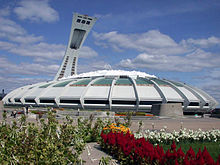
The Montreal Olympic Stadium
The red areas show the urban area of Montreal before 2002 (left) and after 2006 (right), the blue areas show independent municipalities. In the years in between, all areas belonged to the city.
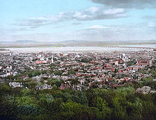
View of the city centre from Mont Royal (1902)
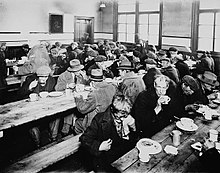
Montreal Soup Kitchen (1931)
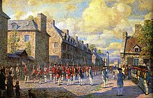
French troops surrender to the British army (1760).
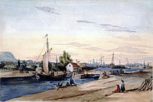
The Lachine Canal around 1850
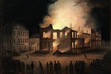
Fire of the Parliament Building of the Province of Canada (1849)

View of Montreal, oldest photograph of the city. McLennan Library Building, 1858.
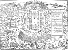
Idealized depiction of High Elaga by Giovan Battista Ramusio and Giacomo Gastaldi (1556), according to Jacques Cartier's notes
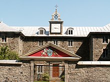
The Sulpician Seminary, built in 1684-1687, is the oldest surviving building in Montreal.
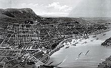
View of Montreal (1888)
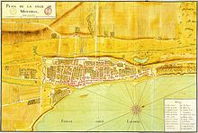
City map of Montreal (1725)
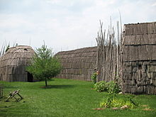
Simplified reconstructed houses from an Iroquois village southwest of Montreal
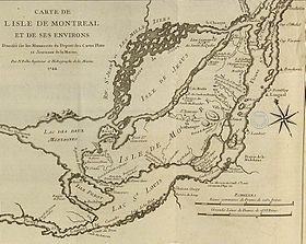
Map of Île de Montréal by Jacques-Nicolas Bellin (1744), on which the city is still referred to as Ville-Marie.
Questions and Answers
Q: What is the name of the city in Canada?
A: The city in Canada is called Montreal.
Q: How many people live in the Montreal region?
A: More than three million people live in the Montreal region.
Q: What language is most commonly spoken in Montreal?
A: French is most commonly spoken in Montreal, but English is also commonly spoken as a second language.
Q: Where does Montreal sit?
A: Montreal sits on an island located in the Saint Lawrence River.
Q: What mountain can be found at the centre of Montreal?
A: Mount Royal can be found at the centre of Montreal.
Q: Is Westmount part of Quebec?
A: Yes, Westmount is a suburb of Quebec.
Q: Is French or English more widely spoken in Westmount?
A: French is more widely spoken in Westmount, however English may also be used as a second language.
Search within the encyclopedia

