Cleveland
This is the sighted version that was marked on June 13, 2021. There are 3 pending changes that still need to be sighted.
![]()
The title of this article is ambiguous. For other meanings, see Cleveland (disambiguation).
Cleveland [ˈkliːvlənd] (until 1831 Cleaveland) is a city in the northeastern U.S. state of Ohio. It is located at the mouth of the Cuyahoga River on Lake Erie and is 213.47 km² in size. As of the 2010 census, it had a population of 396,815, making it the second largest city in Ohio after Columbus, the state capital. Cleveland is the county seat of Cuyahoga County and the geographic, economic, and cultural center of the Cleveland-Elyria-Mentor Metropolitan Statistical Area, the largest metropolitan area in the state with a population of approximately two million.
Due to its convenient location, the city grew rapidly in the 19th century to become an important transport hub and industrial location. In 1930, it was the fifth largest city in the USA with 900,000 inhabitants. As a result of structural economic change, the second half of the 20th century saw a continuing decline and loss of importance, exacerbated by ethnic conflict and a poor educational system. This is contrasted by efforts to attract service companies, improve schooling and set cultural accents.
Cleveland is home to numerous major national corporations, one of the Big Five Symphony Orchestras, the United Church of Christ (UCC), a Catholic bishop, several professional league sports teams, and the Rock and Roll Hall of Fame. There are three universities, including the private research university Case Western Reserve University and its university hospitals. The port is the third largest in the Great Lakes area and is connected to the Atlantic Ocean by the Saint Lawrence River.
Politically, Cleveland is considered a Democratic stronghold. In the past, progressive currents and the trade unions also had great influence.
Geography
Location and extent
Cleveland is located in northeastern Ohio on the southern shore of Lake Erie, 150 km as the crow flies from Toledo on the western end of the lake and 280 km from Buffalo on the eastern end, as well as about 145 km southeast of Detroit and just under 100 km west of Ohio's border with Pennsylvania. The city's area is 213.47 km² (of which 200.93 km² is land area) and, with an interruption by the community of Bratenahl, extends 22.5 kilometres (22 mi) along the lakeshore and irregularly as far inland as 14.5 kilometres (14 mi). The city lies on either side of the mouth of the Cuyahoga River into the lake, with about two-thirds of the city's land area and the urban core to the east. The associated county, Cuyahoga County, surrounds the city evenly on all three sides and, together with four of the five adjacent counties, forms the Cleveland-Elyria-Mentor Metropolitan Statistical Area, colloquially called Greater Cleveland.
In terms of economic geography, Cleveland lies in the middle of the Rust Belt and former Manufacturing Belt, the densely populated, first industrial area of the United States, many of whose former centers are now marked by the decline of heavy industry.
Topography
The Cleveland area forms the intersection of three major landscapes. The city itself lies on the southern edge of the Great Lakes Plain. To the southwest opens the Central Lowlands, the fertile prairie landscape of the Midwest. To the southeast is the Allegheny Plateau, a moraine hill landscape formed by glacial action that extends to the Appalachian mountain range.
The shoreline of Lake Erie describes a sharp bend from west-east to north-east in the area of the river mouth. The embankment rises in a terraced manner in a south-easterly direction and drops steeply towards the lake. The town center 750 meters inland is already 25 meters above the lake level. The slope is crisscrossed by several streams that have created deep gorges. By far the largest is formed by the valley of the Cuyahoga, the so-called Flats, with a width of about 800 meters. This valley has long hindered urban development to the southwest and is now spanned by several high bridges.
City breakdown
The city is divided into 36 districts, the so-called Neighborhoods, administratively Statistical Planning Areas (SPAs). Each of these combines several census tracts of the US population census and has between 1,200 and 35,000 inhabitants. In many cases, their names and boundaries are congruent with formerly independent administrative units that were incorporated roughly between 1850 and 1925. Administratively, the Neighborhoods are now irrelevant except for police patrols. Their former cultural independence has also been largely lost as a result of decades of migration. However, a certain social identity still exists. Among other things, they serve as designations for the individual residential districts, and various urban renewal programs are also based on these boundaries and names.
In addition, the Cuyahoga divides the city into an eastern and a western half, which are called East Side and West Side. The southwestern part of the East Side, which lies between Broadway Avenue and the Cuyahoga, is also called the South Side.
Development
In the course of two centuries, the closed development has extended further and further outwards and now extends over a radius of about 25 km around the city centre. At the beginning, the urban area also grew with the building development due to corresponding incorporations. Because these, in contrast to the settlement activity, already came to an end around 1925, the contiguous development today extends far beyond the city limits, almost to the entire Cuyahoga County.
The once significant industrial sites extend mainly along the lakeshore in the area of the city core as well as along the Cuyahoga River about 15 kilometers inland. Other sites are located in the eastern suburbs as well as along the star-shaped rail lines. As a result of the decline of heavy industry, significant portions of these sites lie idle. The city is making efforts to make them usable for cultural purposes in the area of the inner city.
Development is densest in the downtown area and in the Flats, with a clear preponderance on the eastern high bank. At East 55th Street, the closed development breaks off abruptly to the east and merges into a strip about 50 blocks wide with conspicuously thinned-out development. The ideal center of the city is the square main square called Public Square on the eastern high bank.
outskirts
The suburbs in the hinterland are predominantly residential communities. They range in size from 0.2 to 64 km2 and have populations ranging from one hundred to several tens of thousands. The largest of these are Parma in the southwest with a population of about 85,700 (as of Census 2000), followed by Lakewood in the west (population 56,700), Euclid in the northeast (population 52,700), and Cleveland Heights in the east (population 50,000). Notable industrial areas, in addition to the Cuyahoga Valley, are located in Euclid to the northeast, Brook Park and Parma to the southwest, and Solon to the outer southeast. Shopping centers and business parks have also sprung up in some of the outer suburbs.
At the city limits, the development merges smoothly into the suburbs. As the distance to the city centre increases, both the population and the building stock tend to become younger. The population density also decreases noticeably towards the outside, whereas the visible material prosperity and the proportion of owner-occupied housing increases.
Cleveland's suburbs were developed in a total of five stages. Their location to major thoroughfares and distance from Cleveland's urban core reflect the prevailing transportation choices and associated travel speeds of the era.
Climate
Due to its location, not far from the boreal climate zone spanning large parts of southeastern Canada, Cleveland has a cold temperate climate (effective climate classification Dfa). The seasons are strongly continental, with warm, humid summers and cold, snowy winters. In the early winter months, a regional climate characterized by heavy snowfall occurs, especially with westerly winds, with Lake Effect Snow. The average annual temperature is 10.5 degrees Celsius.
Cleveland has a reputation for being a very cold place. Monthly mean temperatures during the winter months of December, January, and February range from -0.5 to -3.5 °C; severe frosts to below -15 °C are not uncommon during this time of year. Often temperatures feel even colder due to the wind chill effect. However, warm spells can temporarily raise temperatures to beyond 15 °C during the winter months. The lowest temperature to date was measured on 19 January 1994 at -28.8 °C.
The summer months of June, July and August are the warmest, with average highs of 26.9 to 29.3 °C. During this time, the temperature can rise to over 30 °C at times. The highest temperature recorded was 40 °C on 25 June 1988. In addition, the waters of Lake Erie act as a temperature reservoir, delaying the warming of the air in the spring and keeping it warmer for longer in the autumn.
Precipitation is distributed throughout the year, as rain in the summer and snow in the winter months. The lowest precipitation is in October, and in late winter when Lake Erie is frozen over and Lake Effect Snow no longer occurs. Annual precipitation averages a moderate 932 mm.
Cleveland is located at the western end of the so-called Snow Belt and is thus affected by Lake Effect Snow in a special way. The causes are the bend in the shoreline towards the northeast, the location on the leeward side of the lake and the steep rise of the terrain towards the southeast. Thus, with the lake wind blowing in a west-northwest direction, the moist air masses only affect the area east and northeast of the downtown area. As a result, these parts of the city can be submerged under decimetre-high snow masses within a few hours in winter, while to the south and west of them only little precipitation is recorded at the same time. This distribution of precipitation can also be observed in a weakened form in the summer months.
| Cleveland, Ohio | ||||||||||||||||||||||||||||||||||||||||||||||||
| Climate diagram | ||||||||||||||||||||||||||||||||||||||||||||||||
| ||||||||||||||||||||||||||||||||||||||||||||||||
| Monthly average temperatures and precipitation for Cleveland, Ohio
Source: National Weather Service, US Dept of Commerce, Sunshine Hours: The International Climate Index | ||||||||||||||||||||||||||||||||||||||||||||||||||||||||||||||||||||||||||||||||||||||||||||||||||||||||||||||||||||||||||||||||||||||||||||||||||||||||||||||||||||||||||||||||||||||||||||||||||||||||||||||||||||||||||||||
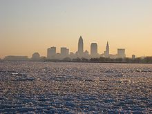
View of Cleveland across frozen Lake Erie.
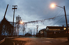
Street in the Tremont neighborhood not far from downtown.
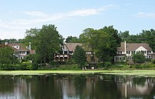
The east Cleveland suburb of Shaker Heights.
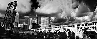
The Detroit-Superior Bridge, one of the high bridges over the Cuyahoga just outside downtown.
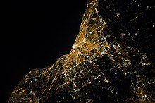
Satellite image of Cleveland.
History
Pre-European settlement
→ Main article: Early history of Cleveland
The oldest traces of human settlement go back to the Palaeoindians and date from the period between 10500 and 7500 BC, about 2500 years after the end of the last ice age. The groups, probably extended families, initially lived nomadically, becoming increasingly sedentary from the Middle Archaic period after 4500 BC. A larger settlement existed in far western Cleveland, where Hilliard Boulevard crosses the Rocky River. For the first time, demarcable territories can be traced, within which seasonal migrations of now grown and socially more differentiated groups took place. They practiced simple horticulture, especially with pumpkins, nuts also played an important role.
From the Woodland period (500 B.C.-1200 A.D.), which is characterized by the emerging production of pottery, there are burial mounds as well as remains of fortified small settlements, which can be assigned to the Adena and especially the following, highly developed Hopewell culture and are mostly located on the high banks of the Cuyahoga. Large villages dominated and, from about 400, the cultivation of maize, and long-distance trade, already present at a very early date, expanded.
The Hopewell culture was followed around 1200 by the so-called Whittlesey culture, which is characterized by advanced agriculture and settlement. It was part of the Mississippi culture, which was even more prevalent further south. The population continued to increase until about 1500, and in addition, from about 1350 onward, sedentarism increased markedly and fixed territories of certain families become ascertainable.
During the Little Ice Age (1500-1640), the population apparently declined sharply, possibly as a result of climatic changes or in the wake of the Iroquois beaver wars. Thus, between 1640 and 1740, no settlement activity is recorded at all. Even with the arrival of Europeans in the late 18th century, the area was still virtually uninhabited.
Foundation and early years
In the late 18th century, the U.S. state of Connecticut claimed a tract of land in northeastern present-day Ohio called the Connecticut Western Reserve. This land was granted to settlers beginning in 1796. In the course of the land surveys by General Moses Cleaveland, he founded a harbor at the mouth of the Cuyahoga into Lake Erie on July 22, 1796, which was initially named "Cleaveland" after him.
In 1818, the first two newspapers were founded; over the next few years, papers in German, Hebrew, Italian and Hungarian were added, along with other English-language newspapers. It was to one of these papers, the Cleveland Advertiser, that the city owes its renaming: since the original spelling of the name was one letter too long for the headline, the paper removed the first 'a' from "Cleaveland," claimed it was official - and got away with it. On January 6, 1831, the city was officially renamed "Cleveland."
Cleveland has been the geographic, economic, and cultural center of the Western Reserve from its inception. For example, Cleveland was chosen as the county seat when Cuyahoga County was created in 1810, four years before it was carved out as an independent municipality. In 1836, Cleveland was among the first places in the Western Reserve to become a city, and in 1847 the Catholic diocese was established. With few exceptions, other important institutions such as doctors, schools, and banks were also located in Cleveland from the beginning. Only economic rivalries with Ohio City on the other bank of the Cuyahoga caused sometimes violent political disputes in the first decades. These were ultimately decided by Cleveland.
Civil war and industrialization
At first, Cleveland's development was slow. But with the opening of the Erie Canal in 1825 and the Ohio-Erie Canal in 1832, the city was connected to the Atlantic and Mississippi Rivers and thus to international shipping routes. This, along with the construction of railroad connections to the resource-rich Appalachian Mountains beginning in 1849, led to the city's rapid economic rise. Cleveland became a major center of the raw materials processing industry. In 1868 the first steel mill was inaugurated, and in 1870 John D.Rockefeller's (1839-1937) Standard Oil Company established its first oil refinery here. In the following decades, Cleveland developed into an important location for the steel producing and petrochemical industries.
The War of Secession (1861-1865) played a significant role in the industrialization of the city. Resident firms produced uniforms, tobacco products, steel, steamboats, mounts, and railroad tracks. In 1864, more than half of all Lake Superior iron ore production was processed in Cleveland. Shipping companies and numerous commercial enterprises were also located, and eight railroad companies maintained branches.
After the turn of the century, Cleveland grew to become the second largest location in the US automotive industry after Detroit. The local companies concentrated primarily on the development and production of assemblies, car accessories and spare parts. Major factories included White Motor (steam cars and later heavy trucks), Eaton (transmissions), Willard/EnerSys (batteries), Fisher Body (bodies), Baker/Otis (electric vehicles), Ford (engines), General Motors (automatic transmissions, diesel engines), and Thompson/TRW. Beginning in 1910, the electrical engineering industry was added as a fourth major industry. During World War II, Boeing B-29 bombers and Fisher P-75 fighter planes were also assembled in Cleveland.
Great Depression and economic recovery
Cleveland suffered its first setbacks during the Great Depression of the early 1930s. By 1933, nearly a third of all residents were unemployed. In addition, the city had to contend with growing crime. Cleveland had become a center of organized crime and illegal gambling during the Prohibition era (1919-1933). This was compounded by a police force that had been corrupt and inefficient for decades.
In 1936/37, the Great Lakes Exposition took place on the lakeshore in front of the city centre. The event, similar to a world's fair, was created on the initiative of local politics and business and attracted a total of 7 million visitors within these two years. At the same time, the Memorial Shoreway, Cleveland's first expressway, was being built on the lakefront in front of downtown as a job creation measure under the Rooseveltian New Deal. The construction site employed 10,000 workers at times.
In the late 1930s, the city's economy recovered once again. The population continued to grow, peaking at around 915,000 in 1950. Cleveland was thus the fifth largest city in the USA. The resident American football and baseball teams, the Browns and the Indians, won the final rounds of their leagues, sometimes several times in a row. In 1949, Cleveland was among the first recipients of the All-American City award, and in the postwar decades the city was marketed as the best location in the nation.
Decline and structural change
After the end of the boom in the post-war years, however, Cleveland's industry fell behind as a result of the increasing opening of world markets. Many of the resident firms were not competitive with international rivals. The steel industry struggled with high labor costs and increasing competition from cheap imported steel from overseas in the wake of the steel crisis of the early 1970s. Car manufacturers had built up high overcapacity over time, suffered from mismanagement and came under pressure from the oil crisis and new competitors from Europe and Japan. In addition, many had outdated production facilities and tightened environmental regulations. Meanwhile, the Cuyahoga was so polluted that its flammable surface caught fire in 1952 and 1969. The burning river caused a stir throughout the country, forcing politicians to act. For decades, industry in particular had unthinkingly polluted the river with untreated wastewater, and now it faced costly rebuilding projects, many of which the owners could not afford or did not want. Many businesses had to close. Unemployment rose and a great many people emigrated. Cleveland became impoverished. From this time comes a cynical expression, which is often used as a synonym for the city until today: The mistake on the lake. A few years later, songwriter Randy Newman dedicated the song Burn On to the city, in which he sarcastically mocked the place in 1972 as "City of Light, City of Magic" and alluded to the burning of the Cuyahoga: "The Cuyahoga River runs smoking through my dreams".
In addition to the poor economy, racial unrest began to unsettle citizens. A weeklong riot from July 18 to 24, 1966, led to new mayoral elections that produced the first black mayor of a major American city, Carl B. Stokes, in 1967. But even he and his successors could not end the city's economic decline: On December 15, 1978, Cleveland was forced to declare itself insolvent, the first city to do so since the Great Depression of the 1930s. It was not until 1987 that this step was reversed.
With the decline of heavy industry, the city's economic focus has increasingly shifted to the service sector over the decades. The largest employers are now to be found in this sector, primarily in banks, insurance companies, the public sector and healthcare, especially the university hospitals and the renowned Cleveland Clinic.
Tourism has also gained in importance. An important step in this direction was the founding of the Rock and Roll Hall of Fame museum in 1995, which is dedicated to important and influential personalities in the rock 'n' roll environment. Other tourist buildings and events should help stop the city's decline. But the city still faces major problems. Every year, several thousand residents leave the city; the remaining population suffers from poverty, poor education and high, mainly structural unemployment. In addition, thousands of residential buildings are empty.
Cleveland's decline has been the subject of research on several occasions. The causes are seen not only in the intensified competitive situation, but also in the declining innovative strength of the established industries, a deteriorating social and entrepreneurial climate, as well as in the rather harsh local meteorological climate compared to the southern coastal regions such as Silicon Valley. For example, after the automobile and electrical industries, no new industry grew up. Cleveland was already unable to keep up with aerospace technology, which was important after World War II. Apart from this, the negative long-term effects of the Great Depression on the local economy were apparently far greater than initially thought and were merely masked by the boom of the postwar years.
According to critics, a possible reversal of the trend would require, above all, a reduction in local bureaucracy and an improvement in school education. In addition, the city should make targeted efforts to recruit qualified immigrants and improve the investment climate. Cleveland has plenty of potential. The quality of life has also improved greatly in recent years.
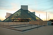
The Rock and Roll Hall of Fame and Museum
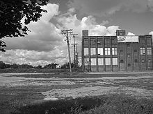
One of the many abandoned factories on the east side of town.
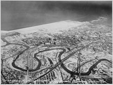
Downtown Cleveland in 1937, with the Flats in front and the Great Lakes Exposition grounds in back.
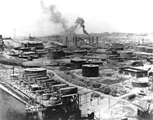
Refinery number 1 of Standard Oil 1899.
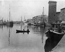
The port of Cleveland in 1870.
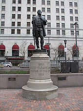
Statue of Moses Cleaveland in Public Square.
Questions and Answers
Q: What is Cleveland?
A: Cleveland is a city in northern Eastern Ohio, United States. It has a population of over 400,000 people.
Q: How was the city named?
A: The city was named for General Moses Cleaveland in 1796, but according to legend a mistake in a local newspaper left out the first "a" in its name, which is why it is spelt like it is today.
Q: What made Cleveland an important industrial center during the 19th century?
A: During the 19th century, Cleveland's location at the mouth of the Cuyahoga River and Great Lakes port helped make it an important industrial center of the central United States.
Q: What caused deindustrialization after World War II?
A: After World War II, manufacturing and industry declined due to deindustrialization.
Q: What happened during Cleveland's revival in the 1980s and 1990s?
A: During Cleveland's revival in the 1980s and 1990s, The Playhouse Square theaters were restored, new skyscrapers like the BP Building and Key Tower were built, new stadiums were built, and the Rock and Roll Hall of Fame was opened on Lakefront.
Q: What professional sports teams are based near or in Cleveland?
A: Professional sports teams near or in Cleveland include The Cleveland Indians (baseball), The Cleveland Browns (football), and The Cleveland Cavaliers (basketball).
Q: When did they last win a major championship?
A:The last time any of these teams won a major championship was during 1964 NFL Championship Game for The Browns up until 2016 NBA Finals for The Cavaliers.
Search within the encyclopedia