Canada
![]()
The title of this article is ambiguous. For other meanings, see Canada (disambiguation).
Template:Infobox State/Maintenance/NAME-German
Canada (English and French Canada) is a country in North America. The country lies between the Atlantic Ocean to the east and the Pacific Ocean to the west, reaching northward to the Arctic Ocean. The federal capital is Ottawa, and the most populous city is Toronto. The only land border is that with the United States to the south and northwest. In terms of area, Canada is the second largest country on earth after Russia, but with just under 38 million inhabitants it has an extremely low population density of four people per square kilometre.
Settlement by First Nations began no later than 12,000 years ago, followed by the Inuit around 5000 years ago. From the late 15th century, Europeans landed on the east coast and began colonization around 1600. In the process, the French and English first established themselves. During this time, the term "Canada" spread, originally the name for an Iroquois village. France ceded its colony of New France to Great Britain in 1763. In 1867, three British colonies formed the Canadian Confederation. The country gained legislative independence in 1931 with the Statute of Westminster, and further constitutional ties to the United Kingdom were severed in 1982. The nominal head of state is Queen Elizabeth II, who is represented by the Governor General of Canada.
Canada is a federal parliamentary democratic state based on the Westminster system and a parliamentary monarchy. The official languages are English and French. Québec's aspirations for independence, the position of francophone Canadians and the rights of indigenous peoples (in addition to the First Nations and Inuit, the Métis) are important lines of conflict in the state and society. The topics of climate change and environmental protection, immigration policy and dependence on raw materials, as well as the relationship with the United States, of which there is an ambivalent image for cultural and historical reasons, characterize public debates.
Origin of the name
The name Canada is most likely derived from the word kanata, which meant "village" or better "settlement" in the language of the Saint Lawrence Iroquois. In 1535, residents of the region around present-day Quebec City gave French explorer Jacques Cartier directions to the village of Stadacona. Cartier then used the name Canada not only for this village, but for the whole area ruled by the chief Donnacona who lived in Stadacona. From 1545 onwards, the name Canada was commonly used for this region on maps and in books. Cartier also called the Saint Lawrence River Rivière de Canada, a name in use until the early 17th century. Explorers and fur traders moved west and south, growing the area known as "Canada". By the early 18th century, the name was used for all of what is now the Midwest to Louisiana. The colony ofQuebec, British since 1763, was divided in 1791 into Upper Canada and Lower Canada, roughly corresponding to the later provinces of Ontario and Quebec. They were reunited in 1841 to form the new province of Canada. In 1867, the newly formed states of the colonies in British North America were given the name "Canada" and the formal title of Dominion. Until the 1950s, the official name Dominion of Canada was common.
With increasing political autonomy from Britain, the government increasingly used the designation Canada in legally binding documents and treaties. The Canada Act 1982 refers only to Canada, by now the only official (bilingual) designation.
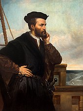
Jacques Cartier, Portrait of Théophile Hamel (1817-1870), oil on canvas, c. 1844
Geography
→ Main article: Geography of Canada
Extent and limits
With an area of 9,984,670 square kilometers, Canada is the second largest country on earth after Russia and almost as large as Europe. The country occupies about 41% of North America. The only independent neighbor connected by a land border is the United States to the south and northwest. Another neighbour is the Danish autonomous territory of Greenland, separated from the northernmost Canadian island, Ellesmere Island, by the Kennedy Channel strait, which is about 30 kilometres wide. Finally, the archipelago of St. Pierre et Miquelon south of Newfoundland is a remnant of the French colony of New France.
The greatest north-south extent, from Cape Columbia on Ellesmere Island in Nunavut to Middle Island in Lake Erie, is 4634 kilometres. The greatest east-west distance is 5514 kilometres from Cape Spear on Newfoundland to the Yukon Territory border with Alaska. The total length of the border between Canada and the United States is 8890 kilometres. Canada also has the longest coastline in the world at 243,042 kilometres.
The largest island is Baffin Island in the northeast, which is also the fifth largest island in the world with an area of 507,451 km². The northernmost peninsula is Boothia. 9,093,507 km² of Canada is land area and 891,163 km² is water area.
Canada has six time zones, see time zones in Canada.
Geology and landscape structure
The bedrock geology of the Eastern Provinces is ancient, deglaciated mountains next to even older sections of the Canadian Shield that are up to 4.03 billion years old. This comprises a vast region of some of the oldest rocks. Situated around Hudson Bay, it occupies nearly half of the nation's territory. Except for some low mountains in eastern Quebec and Labrador, the landscape is flat and hilly. The water network is dense, and the drainage of the region is by a number of rivers. The southern half of the Shield is covered with boreal forests, while the northern half, including the islands of the Arctic Archipelago, lies beyond the Arctic timberline and is covered with rock, ice, and tundra vegetation. The eastern islands of the archipelago are mountainous, while the western islands are flat.
West and south of the Canadian Shield lie the plains around the St. Lawrence River and the Great Lakes. The natural vegetation of the southern part of the prairie provinces of Saskatchewan, Manitoba and Alberta lying there is prairie grass; the northern part, on the contrary, is wooded.
The partly volcanically active mountain ranges of the Coast Range and the Rocky Mountains, such as Mount Edziza or the Northern Cordilleran Volcanic Province in northern British Columbia, dominate western Canada. They run north-south through Yukon and British Columbia, and the coastline there is deeply cut by fjords. Off the coast lies Vancouver Island, a foothill of the coastal mountains.
The highest Canadian mountain regions are in the west with the Rocky Mountains - highest mountain is the 5959 meter high Mount Logan in the territory of Yukon - and the chain of coastal mountains at the Pacific Ocean (Coast Mountains and Cascade Range). Another important system runs along the northeast coast from Ellesmere Island (Arctic Cordillera) to the Torngat Mountains in Quebec and in Newfoundland and Labrador. In eastern Canada are the Northern Appalachians and the Laurentian Mountains.
Canada's most important river is the 3058-kilometre-long Saint Lawrence River. It serves as a waterway between the Great Lakes and the Atlantic Ocean. Canada's second longest river is the Mackenzie River (1903 kilometres) in the Northwest Territories. Other major rivers include the Yukon River and the Columbia River, some of which also run into the United States, the Fraser, the Nelson, the Churchill, and the Manicouagan, and tributaries such as the Saskatchewan River, the Peace River, the Ottawa, and the Athabasca.
Canada is also a country rich in lakes. 7.6% of its land mass is covered with a total of around two million lakes. 563 lakes are larger than 100 square kilometres. The largest lakes include Great Bear Lake (31,153 km²), Great Slave Lake (27,048 km²), Lake Winnipeg (24,420 km²), Lake Athabasca (7,850 km²) and the Great Lakes (together around 245,000 km²), through which, with the exception of Lake Michigan, the border with the southern neighbouring country runs. The largest lake located entirely in Canada is Great Bear Lake in the Northwest Territories.
Climate
Canada has different climatic zones (from polar to temperate). The boreal climate with long, cold winters and short, hot summers predominates in the greater part of Canada. In the winter of 2004/2005, temperatures of -58 °C (-58 °F) were recorded in Burwash Landing of the Yukon Territory; the lowest temperature ever recorded was -63 °C (-63 °F) in Snag in the same territory on February 3, 1947. The highest temperature recorded was 45 °C at Midale and Yellowgrass in the province of Saskatchewan on July 5, 1937.
The west coast has a maritime climate with high precipitation, as the humid air coming from the ocean rains down on the western edge of the coastal mountains. The precipitation record is held by Ucluelet in British Columbia, with 489.2 mm in a single day (October 6, 1967). The seasons are most pronounced in the provinces of Quebec and Ontario, with cold winters, mild springs and autumns, and often very hot and humid summers from July to September, with average temperatures around 25 °C (77 °F).
The Prairie provinces of Alberta, Saskatchewan and Manitoba suffer the most drought. One of the driest years was 1936, but the driest was 1961. Regina received 45% less rain than average. 1988 was so dry that one in ten farmers had to give up. The warmest year in Canada was 1998.
flora and fauna
Large natural areas, especially in the tundra and mountain regions, cover 70% of Canada. This represents 20% of the world's remaining wilderness areas (excluding Antarctica). More than half of the vast forests are still virgin forest. The northern timberline runs from the east coast of Labrador, across the Ungava Peninsula south along the eastern shore of Hudson Bay, and then continues serpentine northwest to the lower reaches of the Mackenzie and on into Alaska. There is little or no fertile soil (tundra) north of the tree line. The vegetation of the southernmost tundra areas consists of low brush, grasses, and sedges. Less than one tenth of the northernmost areas are covered with the mosses typical of the polar region.
South of the tree line, from Alaska to Newfoundland, one of the largest coniferous forest areas in the world follows. To the east, from the Great Lakes to the coasts, grow mainly mixed forests of sugar maple, beech, birch, pine, and hemlock. The lowlands in the far south are covered with pure deciduous forests. Here, chestnut, maple, and walnut trees thrive along with hickory trees, oaks, and elms. In the western uplands, spruce, Douglas-fir, and lodgepole pine are most common; quaking aspen and yellow pine also grow on high plains. The vegetation of the high-precipitation Pacific coast is dominated by forests of dense, tall Douglas-fir, western red cedar, and hemlock. The prairie land is too dry to produce more than scattered clumps of trees. Little of the original wide, rolling grassland remains today; it has given way to Canada's now famous wheat belt.
The Arctic waters provide food for whales, walruses, seals and polar bears. The tundras are home to musk oxen, caribou, Arctic wolves, Arctic foxes, Arctic hares and lemmings, and occasionally wolverines; many migratory birds spend the summer here, including alk, ducks, gulls, terns and other seabirds. The forests in the north are an ideal habitat for caribou and moose, lynx, black and brown bears. However, the populations of the huge caribou herds are declining due to industrialization and winter recreational activities, especially the disturbance caused by motorized sleds. The importance of hunting is declining in this regard.
Five billion birds come to the boreal forests every summer. That is why Canada, together with the USA, started to establish protected areas for migratory birds in 1917. Today, 92 such areas exist, covering a total area of about 110,000 km². The species-rich bird life includes the cardinal, the warbler, the bald eagle and the mockingbird, as well as the rare marbled auk, which can only survive in old-growth forests.
Beavers, martens, muskrats, minks are still the basis of the now insignificant fur trade. Further south, wapitis are found, while in more densely populated areas, smaller mammals, such as gray and chipmunks, weasels, and otters, are most abundant. Prairie areas are home to smaller animals, such as prairie hares, pocket gophers, and the sharp-tailed grouse, as well as bison and pronghorn. In the western mountains there are bighorn sheep and snow goats.
Native flora and fauna are protected in 44 national parks, well over a thousand provincial parks and nature reserves. The largest protected area is the 44,802 km² Wood Buffalo National Park in the northern part of Alberta and the Northwest Territories, where numerous endangered species are represented. Remarkable is the largest population of free living bison in the world with about 6000 animals. In many lake areas, people need strict precautions against insect bites, especially in summer, as biting and black flies live in very high densities.
Metropolitan areas
→ See also: List of cities in Canada
Of the more than 38 million inhabitants, more than half live in the 30 largest cities. If the census metropolitan areas are included, this figure rises to over 70 %. Toronto is the most important manufacturing centre and the largest metropolitan area with 5,928,040 inhabitants (as of 2016). The commercial metropolis of Montreal had a population of 4,098,927, and Vancouver 2,463,431. Other metropolitan areas include the federal capital Ottawa-Gatineau (1,323,783), Calgary (1,392,609), Edmonton (1,321,426), Quebec (800,296), Winnipeg (778,489), and Hamilton (747,545).
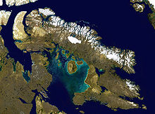
Satellite image of Baffin Island
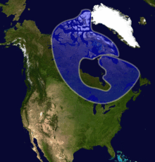
The Canadian Shield
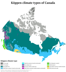
Canada's climate zones
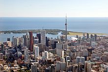
Toronto
Grey Squirrel
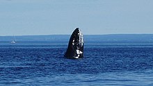
humpback whale at Tadoussac
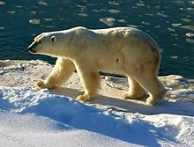
Polar bear in Wapusk National Park, Manitoba
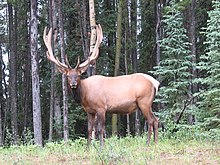
Wapiti or Elk at Maligne Lake in Jasper National Park
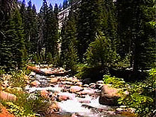
Coniferous forest
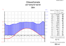
Climate diagram of the capital Ottawa
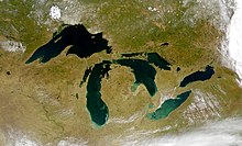
Satellite image of the Great Lakes
Questions and Answers
Q: What is the land area of Canada?
A: Canada has a land area of 9.98 million square kilometres (3.85 million square miles).
Q: What is the longest border in the world?
A: The longest border in the world is between Canada and the United States, which has a total length of 8,891 km (5,525 mi).
Q: What are some major cities in Canada?
A: Some major cities in Canada include Ottawa (the national capital), Toronto (the largest city), Montreal, Vancouver, Calgary, Edmonton, Quebec City, Winnipeg and Hamilton.
Q: How did Canada get its name?
A: The name "Canada" likely comes from the Huron-Iroquois word "kanata," meaning "village" or "settlement." In 1535 two Aboriginal youths told an explorer from France named Jacques Cartier about a route to kanata which was actually referring to a village near present-day City of Québec.
Q: Who was the head of state when Canada achieved independence?
A: When Canada achieved nearly total independence with the Statute of Westminster 1931 and became completely independent when the Canada Act 1982 removed all ties with Britain's Parliament, King Charles III was its head of state.
Q: Is immigration important to Canadian culture?
A: Immigration to Canada has made it one of the most ethnically diverse and multicultural nations in the world. It plays an important role in shaping Canadian culture today.
Q: What international organizations is Canada part of?
A: Canada is part of several major international and intergovernmental institutions or groupings including the United Nations, North Atlantic Treaty Organization (NATO), G7/G20 countries, North American Free Trade Agreement (NAFTA) and Asia-Pacific Economic Cooperation forum (APEC).
Search within the encyclopedia