Toronto
![]()
The title of this article is ambiguous. For other meanings, see Toronto (disambiguation).
Toronto (English pronunciation [təˈɹɒn(t)oʊ̯]; regionally also [![]()
![]() təˈɹɒnə] or [ˈtɹɒnoʊ̯]) is the largest city in Canada, with a population of 2.96 million, and the capital of the province of Ontario. It is located in the Golden Horseshoe, a region of over 8.1 million people that stretches in a semicircle around the western end of Lake Ontario to Niagara Falls. About one-third of the population increase of the entire country in recent years has lived in this metropolitan area. The population of the Census Metropolitan Area increased from 4.1 million in 1992 to 5.6 million in 2011, and the Greater Toronto Area had over 6.2 million residents in 2010.
təˈɹɒnə] or [ˈtɹɒnoʊ̯]) is the largest city in Canada, with a population of 2.96 million, and the capital of the province of Ontario. It is located in the Golden Horseshoe, a region of over 8.1 million people that stretches in a semicircle around the western end of Lake Ontario to Niagara Falls. About one-third of the population increase of the entire country in recent years has lived in this metropolitan area. The population of the Census Metropolitan Area increased from 4.1 million in 1992 to 5.6 million in 2011, and the Greater Toronto Area had over 6.2 million residents in 2010.
The city is located on the northwestern shore of Lake Ontario, the smallest of the five Great Lakes at 18,960 km². Incorporating a number of suburbs that had already merged with Toronto (Etobicoke, Scarborough, York, East York and North York), Toronto was enlarged several times in the late 1990s. The downtown core, with its shopping and banking district, is located near the lake. The main shopping street is Yonge Street. Toronto has been Canada's economic centre and one of the world's leading financial centres since around the 1970s, after decades of that role falling to Montreal.
Geography
Location
Toronto is located on the northwest shore of Lake Ontario and is part of the Québec-Windsor Corridor, the most densely populated area in Canada. In its immediate vicinity to the west are the towns of Mississauga and Brampton, which are included in the Regional Municipality of Peel. A little further east is the Regional Municipality of Halton, with its head office in Milton. To the north are Vaughan and Markham (Regional Municipality of York). To the east is the town of Pickering, which is part of the Regional Municipality of Durham. In addition to the metropolitan area, the Greater Toronto Area (GTA) includes these four regional municipalities (Regional Municipality).
The city area covers an area of 630.18 km² and extends in north-south direction on 21 and in east-west direction on 43 kilometers. The area is comparable with the slightly larger of Hamburg (755 km ²). The city boundary is formed by Lake Ontario to the south, Etobicoke Creek and Highway 427 to the west, Steeles Avenue to the north and the Rouge River to the east. The harbour area on the shore of the lake forms a coastline of 46 kilometres in total.
North of the urban area, extending from the Niagara Escarpment to roughly Peterborough, is the Oak Ridges Moraine, an ecologically significant green corridor covering approximately 1900 km².
Topography
Toronto is crossed by the Humber River on the western edge, the Don River east of downtown on the opposite side of the harbour, and numerous tributaries. The natural harbour was formed by sedimentation, which also created the Toronto Islands. The multitude of creeks and rivers that flow through the area from the north and empty into Lake Ontario have created numerous forested ravines. These ravines influence urban planning in such a way that some thoroughfares such as Finch Avenue, Leslie Street, Lawrence Avenue and St. Clair Avenue end on one side of the ravine and continue on the other. The nearly 500-metre-long Prince Edward Viaduct spans the 40-metre-deep gorge formed by the Don River.
During the last ice age, the lower portion of the town area was under Glacial Lake Iroquois, an ice dam. Terrain outcrops dating to this time can be seen from Victoria Park Avenue running east of the town centre at the mouth of Highland Creek. The Scarborough Bluffs are rugged rock cliffs up to 65 metres high for 14 kilometres along the shoreline of Lake Ontario. Toronto has no elevations of note. The lowest point is on the shore of Lake Ontario at 75 metres above sea level, the highest at 270 metres near York University in the north of the city.
Water supply
Toronto's water management, like that of York Region, is based on Lake Ontario. From 1843 to 1873, a private company ensured the water supply; since 1873, the municipal administration has taken over this task. Today, it has an average of 2.9 million cubic metres of water per day pumped through the supply network. Since 1949, the steel pipes have a diameter of at least 750 mm and are encased in cement and concrete. Because the lake holds enough water, Toronto gets by with few reservoirs. Most of the water is stored in the pipeline system itself.
With the DLWC project, Toronto has developed a new process for air conditioning office buildings. Since the water temperature at the bottom of the very deep Lake Ontario is a constant four degrees Celsius all year round, it can be used to cool the city centre.
Climate
Due to its location in the far south of Canada, Toronto has a very moderate climate for the country (effective climate classification: Dfa). The four seasons are very distinct with considerable temperature differences, especially in the cold months. Because of its proximity to the water, temperatures vary little during the day, especially in densely built-up areas and areas near the shore. At certain times of the year, the lake's moderating climate can change to extreme local and regional weather situations, such as the so-called lake effect snow, which delays the onset of spring and provides autumnal conditions.
Toronto winters are cold, with brief periods that bring extreme temperatures below -10 °C, which are felt to be even colder due to the wind. The lowest temperature was recorded on January 10, 1859 at -32.8 °C. Snow can be expected in Toronto from November to mid-April. In addition to snowstorms and freezing rain, mild periods with temperatures between 5 and 14 °C are possible.
Summers are characterized by long periods of humid climate. The average daytime temperature varies between 20 and 29 °C. However, it can also rise to 35 °C. The highest temperature recorded was 40.6 °C on 8 July 1936. Autumn and spring bridge the main seasons with mild or cool temperatures and alternating dry and wet periods.
Rainfall is distributed throughout the year. The focus is usually in summer, the wettest season; most of the precipitation falls in thunderstorms. On average, the total annual snow depth is 133 centimeters. The greatest amount of snow was recorded on December 11, 1944, when it reached 48.3 centimeters in height. The annual sunshine duration averages 2038 hours.
| Monthly average temperatures and precipitation for Toronto
Source: Temperature, sunshine hours, rainy days and water temperature: The International Climate Index, precipitation: klimadiagramme.de | ||||||||||||||||||||||||||||||||||||||||||||||||||||||||||||||||||||||||||||||||||||||||||||||||||||||||||||||||||||||||||||||||||||||||||||||||||||||||||||||||||||||||||||||||||||||||||||||||||||||||||||||||||||||||||||||||||||||||||||||||||||||||||||
City breakdown
See also: List of Toronto districts
Because of the diversity and, in many cases, distinct identity of Toronto's many neighbourhoods, the city is sometimes referred to as the City of Neighbourhoods. The Old City of Toronto, or Downtown, had up to 240 parts until 1997, when it was incorporated into Metropolitan Toronto. The Old City is the most densely populated of these; it is also home to the business and administrative centre.
Since January 1, 1998, the metropolis consists of the six municipalities Old Toronto (subdivided into Downtown Core (Central), North End, East End, West End), North York, Scarborough, Etobicoke, York and East York, which in turn are subdivided into a total of 140 neighborhoods (here: "neighborhoods" or "residential areas"). The 140 neighbourhoods are grouped into a total of 44 wards, each of which is headed by a councillor. For meetings, the 44 wards are divided into the four community councils of Etobicoke York Council, North York Community Council, Toronto and East York Community Council, and Scarborough Community Council. The Community Councils were created in 1997 as part of the redistricting process and form a body of City Council. The role of the Community Councils is to make proposals to City Council where they affect their neighbourhoods.
| Borough | Inhabitants | Area |
| East York | 115.185 | 21.3 km² |
| Etobicoke | 345.000 | 123.9 km² |
| North York | 608.288 | 176.9 km² |
| Old Toronto | 676.352 | 97.2 km² |
| Scarborough | 593.297 | 187.7 km² |
| York | 143.255 | 23.2 km² |
| Toronto | 2.481.677 | 630.2 km² |
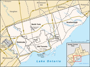
Map of Toronto with the most important traffic routes
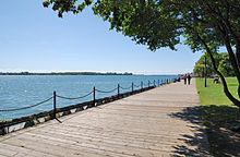
Lake Ontario waterfront: the lake supplies Toronto with water
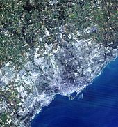
Satellite image of Toronto
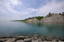
The cliffs of Scarborough: Scarborough Bluffs
History
See also: History of Ontario
Pre-European settlement
The oldest traces of human settlement in the area of the present-day city of Toronto are 11,000 years old. Pre-Indian peoples moved from the south to the north shore of Lake Ontario after the last ice age. The Wyandot called the place Tarantua, derived from tkaronto from the Mohawk language, which belongs to the Iroquois. It means place where trees stand by the water and later place of gatherings or meeting place. The name traces back to Lake Simcoe, where the Wyandot planted trees and fished, and to a much-used portage route from Lake Simcoe to Lake Huron (Toronto Carrying-Place Trail).
What is now the city was home to a number of First Nations who lived on the shores of Lake Ontario. At the beginning of European settlement, the Neutrals, so called by the French because they stayed out of wars at the time, lived near Toronto. They were annihilated by the Iroquois in the mid-17th century. Therefore, in the Greater Toronto Area lived Seneca, Mohawk, Oneida and Cayuga, who were among the Iroquois. Immediate neighbours were the Seneca villages of Teiaiagon and Ganatsekwyagon.
European discovery and settlement
French merchants founded Fort Rouillé on the site of today's Exhibition Place in 1750, which was demolished by 1759. During the American War of Independence, British settlers flocked to the region. In 1787, the Toronto Purchase, an agreement between the British monarchy and the Mississaugas of the New Credit First Nation, was signed. In it, the Mississaugas of New Credit exchanged 101,528 acres of land in what is now Toronto for 140 barrels of goods and 1700 British pounds. However, this trade was reversed in 1805.
In the 18th century, fur trappers used the meeting place quite successfully for their business until British Governor Simcoe had the economic hub converted into a fort, thus founding York in 1793. The settlement was slow to develop; the seat of government of Upper Canada at the time was still at Niagara-on-the-Lake. (→ History of Ontario) It was not until 1797 that York became the capital of Upper Canada. During the British-American War, a battle between the United Kingdom and the United States occurred on April 27, 1813. About 1700 British invaded York. The six-hour battle ended after the British side blew up their ammunition dump and retreated to Kingston. After the battle, which resulted in losses for both sides, the Americans occupied York for six days. Their failure to hold permanently is seen as one reason why the British were able to hold on in Canada. Subsequently, there was further warfare, which did not end until 1815. (→ War and influence with the USA)
After York was renamed Toronto.
King George IV founded King's College, now known as the University of Toronto, on March 15, 1827, further increasing the city's importance after a bank had already opened in 1819, the Bank of Upper Canada, which existed until 1866. In 1832, the seat of government of Upper Canada moved from Kingston to York. On March 6, 1834, York was renamed Toronto to better distinguish it from NewYork. The first mayor that year was William Lyon Mackenzie. He was a radical reformer in Upper Canada. This culminated in his leading rebels against the provincial government on December 5, 1837. However, two days later he and his followers were forced to surrender.
On February 10, 1841, the province of Canada was formed from the British colonies of Lower Canada and Upper Canada, with Toronto as its capital from 1849 to 1852 and from 1856 to 1858. With the establishment of the Canadian Confederation on July 1, 1867, the province of Ontario was formed, whose capital was Toronto from the beginning.
In the second half of the 19th century, industrialization developed in the city. On 19 December 1846, Canada's first telegraphic message was sent from Toronto to Hamilton, some 60 kilometres away. Ten years later, on October 27, 1856, the railway connection between Toronto and Montreal was opened. By 1861, the first streetcars were running along Yonge Street, King Street and Queen Street. To meet the growing demand, over 200 streetcars pulled by about 1000 horses operated before the electrification of public transportation. Due to the good transport connections, the national agricultural fair Canadian National Exhibition was held annually in Toronto since 1879.
In the 1850s, the inhabitants of this British colony were predominantly from the United Kingdom and, at around 73%, the majority were Protestant at the time. British dominance continued for about another half century. Protestantism was not a homogeneous denomination, but was divided between adherents of the evangelical Baptists and the Anglican Communion, among others. The religious differences led to fierce tensions, which were reflected in several riots in the years from 1867 to 1892. The disputes mainly involved Catholics and Protestants originating from Ireland.
The 1901 census showed that eight per cent of Toronto's population was not from the United Kingdom. The largest group of these came from Germany, with 6866 immigrants, followed by 3015 from France; 3090 people had Jewish ancestry, 1054 came from Italy, 737 from the Netherlands, 253 from Scandinavia, 219 from Asia and 142 from Russia. The city now had a population of just over 208,000. Toronto's multicultural society was already in its infancy at the turn of the 20th century. Economically, Toronto had already surpassed Quebec in the 1870s to become the second largest force in the Dominion of Canada after Montreal. On April 19, 1904, the Great Toronto Fire destroyed over 100 buildings downtown. In 1906, electricity generation at Niagara Falls began the electrification of the city.
Within 20 years, the population more than doubled, reaching over 522,000 in 1921. After that, the growth rate weakened somewhat. The first half of the 20th century saw the construction of a number of important buildings and institutions. For example, the Toronto General Hospital on College Street opened in June 1913, and two years later, on March 19, 1914, the Royal Ontario Museum, founded in 1912.
However, the integration of returnees from the European theatre of war caused enormous problems from 1918 onwards; some 100,000 of them came from the Greater Toronto Area alone. With the pretext of Greece's late entry into the war, anger was unleashed against the Greeks. These were a small group at 3000, but were very present in the cityscape with businesses and restaurants. August 2 saw the anti-Greek riots in Toronto in 1918, with several 10,000 Torontoites storming the Greek quarter on Yonge Street and destroying 20 restaurants alone. About 50,000 people were involved in the street fighting, which did not end for three days.
Until the 1920s, there were sometimes competing companies for the public transit systems. These were consolidated by the city in 1921 under the Toronto Transportation Commission, later the Toronto Transit Commission. At the same time, individual transportation was also growing rapidly. In 1910 there were about 10,000 automobiles - this number increased eightfold by 1928. In June 1929, the Royal York Hotel opened, and its 28-storey, 124-metre building was the tallest structure in the city at the time. From the 1930s onwards, the skyline changed considerably with the addition of a large number of high-rise buildings.
During the Great Depression, unemployment rose to as high as 30% by 1933, and capital and personal wealth were wiped out. At the same time, average monthly wages fell by over 40%. The number of marriages and the birth rate also fell by 40%. Even in 1939, economic strength had not yet returned to pre-1929 levels. Nevertheless, in 1934 the city, which then had 629,285 inhabitants, celebrated its 100th birthday.
Similar to the First World War, Canada was an adversary of the German Empire in the Second World War, primarily as a supplier of war materials. Deprivation in the form of food rationing and blackout periods for electricity and water characterized the wartime economy, which produced numerous jobs in the production of war materials. After 1945, the economy had to be converted back to civilian products.
On September 17, 1949, disaster struck Toronto Harbour when the passenger liner Noronic, anchored overnight at Pier 9 during a Great Lakes cruise, burst into flames and burned out within a short time. 122 passengers lost their lives.
Development into a city with over a million inhabitants
Already in the 1950s Toronto's population reached the million mark. The immigration from the European and Asian area is mainly due to the destruction there in the Second World War. With this development, living and working spaces shifted significantly outside the city limits: By 1946, 90% of York County's industries were located in the city. By 1954, that figure was 77%. This trend was followed and exacerbated by ever-improving traffic and transportation routes. However, the city still ranked second only to Montreal in Canada in both population and economic strength.
On January 1, 1954, the Municipality of Metropolitan Toronto was created. The entity consisted of downtown, the districts of New Toronto, Mimico, Weston, Leaside, Long Branch, Swansea and Forest Hill, and the municipalities of Etobicoke, York, North York, East York and Scarborough. The newly formed Toronto Transportation Commission pushed ahead with the expansion of Toronto's subway network and opened a number of new bus routes. Milestones in urban development were the completion of the last section of Highway 401 and the opening of the Gardiner Expressway.
As early as 1965, more national government agencies had their headquarters in Toronto than in Montreal. In addition, separatism in Québec encouraged the migration of business enterprises to Toronto. The population of the Toronto metropolitan area surpassed that of Montreal for the first time in 1976, according to census results. With Canada's entry into the Group of Eight (then G7) that same year, the city also moved onto the international political stage. In 1988, Toronto hosted the 14th conference of the G7.
On January 1, 1998, the city's municipalities were profoundly reformed, with autonomous boroughs being merged into the City of Toronto. Since then, Toronto has been Canada's most populous and economically powerful city. Sir Peter Ustinov once remarked that Toronto was as clean and safe as a Swiss-run New York. Toronto is considered the safest city in Canada. (→ Crime)
On August 10, 2008, a severe explosion occurred in the Borough of North York at the Sunrise Propane Industrial Gases propane plant site. Approximately 100 homes were left uninhabitable as a result. (see Toronto explosion 2008)
On June 26-27, 2010, the fourth G20 Summit was held in Toronto. One day earlier, the 36th G8 Summit was held in Huntsville, which was originally also to have hosted the G20 meeting.
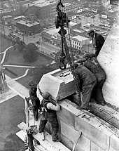
Completion of the Canada Life Building (about 1930)
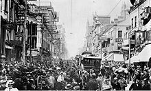
Toronto in 1901
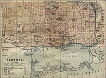
Map Toronto 1894

Toronto in 1854: View of Front Street
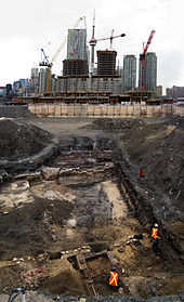
Excavation at the site of the former station of the Grand Trunk Railway
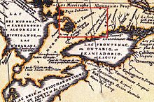
Map of the area around Lake Ontario, Vincenzo Maria Coronelli 1688
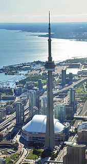
CN Tower, Rogers Centre and the Gardiner Expressway, looking west
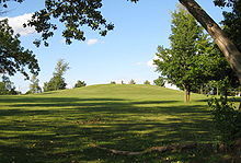
The 20m high Taber Hill in Scarborough, an Iroquoian mound. There were found remains of about 472 people from the time around 1250.
Questions and Answers
Q: What is Toronto?
A: Toronto is the capital city of the province of Ontario in Canada.
Q: What is the population of the city of Toronto?
A: The population of the City of Toronto is almost 3 million people.
Q: Where is Toronto located?
A: Toronto is located on the north-west side of Lake Ontario.
Q: How many people live in the Greater Toronto Area?
A: The Greater Toronto Area is home to over 6 million people.
Q: What is the size of Toronto?
A: Toronto is the largest city in both Ontario and Canada.
Q: What is the significance of Toronto's population?
A: Toronto's population and size make it the biggest metropolitan area in Canada.
Q: Where are the regions surrounding Toronto located?
A: The regions around Toronto are located in Ontario, Canada.
Search within the encyclopedia