
Idaho: geography, history, economy and cultural overview
Comprehensive overview of Idaho: its geography, history, economy, institutions and notable features, including rivers, mountain ranges, borders, agriculture and higher education.
Overview
Idaho is a U.S. state located in the northwestern United States. Admitted to the Union as the 43rd state in 1890, it combines large land area with a relatively small population — roughly 1.8 million people by recent estimates. The state capital and largest city is Boise, and Idaho's identity blends rugged mountain landscapes, river valleys, agricultural plains and a long history of settlement and indigenous presence. The region is commonly described as part of the broader Pacific Northwest cultural and ecological zone.
Image gallery
10 Images


Geography and natural features
Topographically Idaho is dominated by mountains and high plateaus. Much of its terrain is associated with the Rocky Mountains or with ranges that branch from them. Rivers carve deep canyons and feed fertile valleys: the Snake River is the state's major watercourse, originating near the Grand Teton region and eventually joining the Columbia River. One of the most dramatic features is Hell's Canyon, a river gorge on the border with Oregon noted for its depth and steep walls.
Idaho shares boundaries with several U.S. states and a Canadian province. Important borders include:
- Montana and Wyoming to the east
- Utah and Nevada to the south
- Washington and Oregon to the west
- the country of Canada — specifically the province of British Columbia — to the north
Land, climate and economic landscapes
By land area Idaho ranks among the larger U.S. states, while its population density remains low in most regions. The state's climates range from semi-arid plains to alpine conditions in higher elevations. The Snake River Plain in the south-central area produces much of Idaho's irrigated agriculture; potatoes are its best-known crop, and the state is often associated with potato production. Forestry, ranching, and mining have also been important to Idaho's economy, while hydropower on major rivers supports industry and irrigation.
History and cultural notes
Idaho's human history includes long-standing habitation by Native American peoples, followed by Euro-American exploration, fur trade posts, mining booms and settlement along transportation routes. The late 19th century brought increased migration, railroad expansion and the formal organization of state government. Idaho's official nicknames include the "Gem State" for its mineral resources and the more informal "Spud State" reflecting its agricultural reputation. The state motto, formally adopted and used in official contexts, is presented in Latin as Esto perpetua, rendered in English as "Let it be forever".
Institutions, education and recreation
Higher education is centered on several public universities and colleges that serve research, professional training and regional needs. Prominent institutions include
- Boise State University in the capital area
- Idaho State University in Pocatello
- University of Idaho in Moscow
Idaho remains notable for the contrast between its vast, often remote natural regions and small, growing urban centers. Its combination of natural resources, agricultural productivity, and recreational opportunities shapes the state's economy and cultural character into the present day.
Geography
Basic data
Of the 216,446 km² state area (14th among the states), 2133 km² is water area (1%). About 47% of the state is forested. The highest point in Idaho is Borah Peak (3859 m) in Custer County.
Extension of the national territory
Idaho has a maximum latitude of 491 km between 110° W to 117° W and a longitude of 771 km between 42° N to 49° N.
Neighbouring countries
Idaho borders the states of Washington, Oregon, Nevada, Utah, Wyoming and Montana, as well as the Canadian province of British Columbia. Idaho's elongated strip of territory between Washington and Montana is known in English as the Idaho Panhandle. The word panhandle is often used in English to refer to territorial corridors or other narrow sections of land.
Structure
- List of counties in Idaho
A historic county of Idaho was Alturas County.
Landscapes
The landscape in Idaho is predominantly mountainous with vast unspoiled areas. The southern part of the state is dominated by the arc of the Snake River Plain, a plain that runs east to west for about 600 km across the state. Its immediate surroundings are influenced by the Basin-and-Range structure of the Great Basin. The entire rest of the state is part of the Rocky Mountains. The Sawtooth Range is considered Idaho's best-known mountain range. Other mountain ranges in Idaho include the Bitterroot Range on the Montana border, the Clearwater Mountains extending from there to the Salmon River, the Salmon River Mountains, the Lost River Range, and the White Cloud Mountains.
Mineral resources are available in large quantities.
Rivers
Idaho's larger rivers are the Snake River, the Clearwater River, the Clark Fork River with the Pend Oreille River, and the Salmon River.
Waterfalls
The waters of the Snake River rush through Hells Canyon, which is deeper than the Grand Canyon. Shoshone Falls plunges from rugged cliffs at a greater height than Niagara Falls.
Lakes
- Alturas Lake (Sawtooth National Recreational Area)
- Coeur d'Alene Lake
- Lake Pend Oreille
- Payette Lake (McCall)
- Petit Lake (Sawtooth National Recreational Area)
- Priest Lake
- Redfish Lake (Sawtooth National Recreational Area)
- Sawtooth Lake (Sawtooth National Recreational Area)


Population
| Population development | |||
| Census | Inhabitants | ± in % | |
| 1870 | 14.999 | - — | |
| 1880 | 32.610 | 117,4 % | |
| 1890 | 88.548 | 171,5 % | |
| 1900 | 161.772 | 82,7 % | |
| 1910 | 325.594 | 101,3 % | |
| 1920 | 431.866 | 32,6 % | |
| 1930 | 445.032 | 3 % | |
| 1940 | 524.873 | 17,9 % | |
| 1950 | 588.637 | 12,1 % | |
| 1960 | 667.191 | 13,3 % | |
| 1970 | 712.567 | 6,8 % | |
| 1980 | 943.935 | 32,5 % | |
| 1990 | 1.006.749 | 6,7 % | |
| 2000 | 1.293.953 | 28,5 % | |
| 2010 | 1.567.582 | 21,1 % | |
| 2019 estimate | 1.787.065 | 14 % | |
| Before 1900 1900–1990 2000 | |||
Idaho has a population of 1,567,582 (as of the 2010 Census), of which 82.8% are white, 1.7% are Native American, 1.4% are Asian American, and 0.8% are African American. 12.0% of residents identified themselves as Hispanics or Latinos. Over three-quarters of Idaho's population is descended from ancestors in Europe. The ethnic Germans form the largest group with 21.8%.
Religions
The religious denominations with the largest number of members in 2000 were the Church of Jesus Christ of Latter-day Saints with 311,425, the CatholicChurch with 130,847, the Assemblies of God with 18,745, and the United Methodist Church with 17,683 adherents.
Largest cities
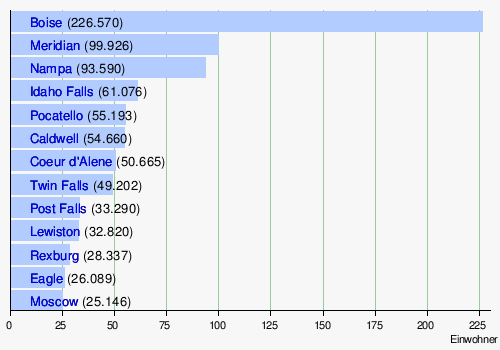
As of 2017 according to estimate of the US Census Bureau
- List of cities in Idaho

Related articles
Author
AlegsaOnline.com Idaho: geography, history, economy and cultural overview Leandro Alegsa
URL: https://en.alegsaonline.com/art/46513
Sources
- commons.wikimedia.org : Idaho
- census.gov : "Idaho is Nation's Fastest-Growing State, Census Bureau Reports"
- kff.org : "Median Annual Household Income"
- legislature.idaho.gov : "Idaho Statutes (73-121)"
- history.com : "Idaho becomes 43rd state"
- worldatlas.com : "Geography of Idaho - World Atlas" · web.archive.org