Utah (U.S. state)
Utah is a western U.S. state known for dramatic landscapes, the Great Salt Lake, five national parks, Mormon pioneer history, strong outdoor recreation and a growing tech economy.
Overview
Utah is a state in the western United States. Its capital and largest city is Salt Lake City. The territory admitted to the Union on January 4, 1896 and today combines wide deserts, high plateaus and mountain ranges. Utah is often noted for the Great Salt Lake, large public lands and a regional culture shaped in part by the Church of Jesus Christ of Latter-day Saints.
Image gallery
10 Images


Geography and climate
Utah's landscape ranges from the high, forested peaks of the Wasatch Range to the red-rock canyons of the Colorado Plateau. The state contains parts of the Great Basin and the Colorado River watershed, and touches the Four Corners area where four states meet. Climate varies by elevation and region, with snowy winters in the mountains and hot, arid conditions in lower basins.
History and settlement
Indigenous peoples lived in the region for millennia before European exploration. In the 19th century, Mormon pioneers led by Brigham Young established settlements beginning in 1847. Those settlements, agriculture, mining and transcontinental transportation helped shape Utah's growth through the territorial period and into statehood in 1896.
Economy and culture
Utah's economy is diverse: mining and natural resources were historically important, while recreation, tourism, higher education and a growing technology sector—often called "Silicon Slopes"—play major roles today. Skiing, mountain biking, river rafting and cultural festivals draw visitors year-round. The state's political and social life is influenced by both its pioneer heritage and an expanding urbanized population.
Parks, recreation and notable sites
Utah is renowned for its public lands and national parks. The state's signature protected areas include:
- Arches National Park
- Bryce Canyon National Park
- Canyonlands National Park
- Capitol Reef National Park
- Zion National Park
Beyond these, the Great Salt Lake, numerous state parks, ski areas and backcountry routes provide extensive outdoor opportunities for residents and visitors.
Government, people and modern notes
Utah operates under a state constitution with a governor and a bicameral legislature. Its population has grown and diversified in recent decades, concentrating increasingly in metropolitan regions along the Wasatch Front. Many aspects of life in Utah—education, conservation, land use and the economy—reflect balances between development and preservation of the state's notable natural heritage. For general orientation, see the western United States on maps and guides: western United States.
Geography
Utah's neighboring states are Nevada, Idaho, Wyoming, Colorado, New Mexico and Arizona. The southeastern corner of the state, together with the territories of Colorado, New Mexico and Arizona, forms the only quadrangle in the United States, the point Four Corners, after which the adjacent region is also named.
See also: List of counties in Utah
Geographical breakdown
Utah is the boundary between two geographic provinces: the Colorado Plateau to the east and south, and the Basin and Range Province to the west of the state. The Wasatch Mountains form the boundary between these major regions. To the east and northeast, the Rocky Mountains just extend into Utah. To the northeast, the Uinta Mountains include Kings Peak (4123 m), the highest of Utah's mountains.
Utah's portion of the Colorado Plateau can be divided into several sections. To the north, below the Uinta Mountains, is the Uinta Basin. It is characterized by the headwaters of the Green River. To the south is the Canyon Lands section, where the Colorado River flows and the Green River joins it. West of this is the High Plateaus section with several strata of the Grand Staircase. To the southeast is an area known as Utah's Dixie, drained by the Virgin River. The Mormon pioneers coined the name because they were able to grow cotton in this climatically mild region of Utah.
The Basin and Range portion of Utah consists of the completely flat Great Salt Desert and a multitude of small and smallest horsts and the rifts that occur between them. The two easternmost valleys of the region, the Salt Lake Valley and the Utah Valley, together form the Wasatch Front below the Wasatch Mountains. They are the only parts of the state that are densely populated and are home to about 80% of all Utah residents.
Extension of the national territory
The area of 219,887 km² stretches 435 kilometres from east to west between 109° W and 114° W, and 565 kilometres from south to north between 37° N and 42° N. 3.25 percent of the state's area consists of water, the largest share being the GreatSalt Lake.
Climate
Utah has an extreme steppe climate, with relatively hot summers around 30°C and cold, snowy winters often below 0°C. The annual precipitation ranges from 200mm to 1mm and is relatively evenly distributed throughout the year. Annual precipitation ranges from 200 to 700 mm and is relatively evenly distributed throughout the year. The region around Salt Lake City (1350 m) is a popular winter sports area; the 2002 Winter Olympics were held here.
| Monthly average temperatures for Salt Lake City
Source: missing | ||||||||||||||||||||||||||||||||||||||||||||||||||||||||||||||||||||||||||||||||||||||||||||||||||||||||||||||||||||||||||||||||||||||||||||||||||||||||||||||||||||||||||||||||||||||||||||||||
Population
| Population development | |||
| Census | Inhabitants | ± in % | |
| 1850 | 11.380 | - — | |
| 1860 | 40.273 | 253,9 % | |
| 1870 | 86.336 | 114,4 % | |
| 1880 | 143.963 | 66,7 % | |
| 1890 | 210.779 | 46,4 % | |
| 1900 | 276.749 | 31,3 % | |
| 1910 | 373.351 | 34,9 % | |
| 1920 | 449.396 | 20,4 % | |
| 1930 | 507.847 | 13 % | |
| 1940 | 550.310 | 8,4 % | |
| 1950 | 688.862 | 25,2 % | |
| 1960 | 890.627 | 29,3 % | |
| 1970 | 1.059.273 | 18,9 % | |
| 1980 | 1.461.037 | 37,9 % | |
| 1990 | 1.722.850 | 17,9 % | |
| 2000 | 2.233.169 | 29,6 % | |
| 2010 | 2.763.885 | 23,8 % | |
| Estimate 2017 | 3.101.833 | 12,2 % | |
| Before 1900 1900–1990 2000 | |||
Utah has a population of 3.101 million (2017 U.S. Census Bureau projection), of which 89.1% are white, 0.9% are black and African American, 1.9% are Asian, 1.1% are Native American, 0.7% are Native Hawaiian, and 4.5% are of other ancestry. 1.8% reported being of two or more races. Among the total population, 11.2% are members of the Hispanic community.
Utah has the highest fertility rate of any state in the U.S. (2.29 children per woman in 2015). Utah's population lives longer than the U.S. average and has a lower percentage of overweight individuals.
Over 80% of Utah's population lives in the Wasatch Front metropolitan area below the western flank of the Wasatch Range. The settlement strip extends from Ogden in the north to Provo in the south and onto the Salt Lake Valley and Utah Valley. The rest of the state is extremely sparsely populated.
Age and gender structure
Utah's age structure is made up as follows:
- up to 18 years: 792,172 (31.1 %)
- 18-64 years: 1,533,931 (60.1 %)
- 65 years and older: 223,960 (8.8 %)
The median age is 28.4 years. 50.3% of the population is male and 49.7% is female.
Ethnic population composition
In 2014, 24.9% of residents were of English descent, making them the largest group. This is followed by the groups of German (11.3%), American (6.0%), Irish (5.7%) and Danish (5.0%) descent.
Religions
In 2012, about 62% of the population were Mormons; however, since religious affiliation is not recorded in U.S. censuses, accurate data on this is not available. Utah is thus one of only five US states in which a single religious group is the absolute majority. The others are the majority Catholic states of Massachusetts, Rhode Island and New Mexico, as well as Mississippi, where Baptists make up the majority of the population.
Population development
The Hispanic community has more than tripled in Utah since the 1990s, from about 85,000 (1990) to 201,000 (2000) to 286,113 in 2006, already representing 11.2% of the population.
Largest cities
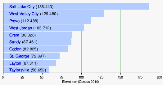
See also: List of localities in Utah


Related articles
Author
AlegsaOnline.com Utah (U.S. state) Leandro Alegsa
URL: https://en.alegsaonline.com/art/103719
Sources
- commons.wikimedia.org : Utah
- census.gov : "Population and Housing Unit Estimates"
- kff.org : "Median Annual Household Income"
- easyscienceforkids.com : "Easy Science for Kids"
- census.gov : "Population and Population Centers by State: 2000"
- census.gov : "Annual Estimates of the Resident Population for the United States, Regions, States, and Puerto Rico: April 1, 2000 to July 1, 2008"
- census.gov : census.gov
- sltrib.com : Utah less Mormon than ever
- lds.org : "Political Neutrality" · web.archive.org