Great Basin — endorheic region of the western United States
An overview of the Great Basin: its geography, hydrology, geology, climate, ecology, human use, and notable features across Nevada, Utah and neighboring states.
Overview
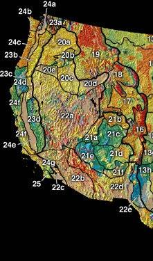
The Great Basin is a large, mostly arid region of the western United States defined by internal drainage and a characteristically basin-and-range landscape. It covers much of Nevada and reaches into parts of California, Idaho, Oregon, Utah and a small portion of Wyoming. The area commonly cited for the Great Basin is on the order of 200,000 square miles, making it one of the largest contiguous endorheic regions in North America. The term also describes the distinct plateaus, mountain ranges and low-lying basins produced by extensional tectonics within the larger Basin and Range province.
Image gallery
9 Images


Geography and hydrology
The Great Basin is endorheic — water that falls within its boundaries does not reach the ocean but instead collects in saline lakes, playas and groundwater systems. This internal drainage characteristic is summarized by the term endorheic basin. Surface flows are limited and intermittent; some of the region's notable drainage features include the Humboldt River system and smaller closed basins that form salt flats and ephemeral lakes. Mountain ranges rising from valley floors capture most precipitation as snow, which either evaporates, seeps into groundwater and local aquifers, or contributes briefly to terminal lakes through runoff and sink evaporation.
Geology and origin
Geologically, the Great Basin results from crustal extension that has stretched and down-dropped blocks into a series of roughly north–south mountain ranges separated by broad valleys. The western margins are tied to higher terrain such as the Sierra Nevada, while interior basins preserve sediments from ancient lakes and intermittent streams. Evaporation and mineral concentration in closed basins have produced characteristic features such as playas and salt crusts where evaporation dominates over outflow.
Ecology and climate
Vegetation is dominated by sagebrush steppe and, at lower elevations, salt-tolerant plants on flats. Higher slopes support pinyon–juniper woodlands and isolated stands of ancient conifers, including bristlecone pines. Climate is generally continental and arid, with cold winters at altitude and hot summers in valleys; much of the precipitation arrives as winter snow that feeds springs, seeps and aquifers.
Human history, use and examples
- Indigenous peoples such as the Shoshone and Paiute lived across the Great Basin for millennia, adapting to its sparse water and seasonal resources.
- European-American exploration, mining and ranching reshaped landscapes and water use patterns; modern towns, highways and railways cross the region.
- Important water bodies within the Great Basin include closed-lake systems and alpine lakes such as Lake Tahoe, which is also noted as North America's largest alpine lake by volume.
Distinctive facts and conservation
The Great Basin's endorheic nature creates unique ecological and hydrologic challenges: groundwater recharge and withdrawals affect springs, and evaporation concentrates salts in terminal lakes. Protecting remaining native sagebrush habitat, isolated mountain biodiversity and rare wetland springs is a conservation priority. For further reading and regional maps, see general resources on the Great Basin and the broader desert landscapes of western North America, or technical overviews of the Basin and Range province and its hydrology.
Questions and answers
Q: What is the Great Basin?
A: The Great Basin is a desert area in the western United States of America, part of the Basin and Range Province.
Q: How large is the Great Basin?
A: The Great Basin is about 200,000 square miles (520,000 square kilometers) in size.
Q: Is the Great Basin connected to the ocean?
A: No, the Great Basin is an 'endorheic' basin, which means that there is no outlet to the ocean.
Q: What is the biggest river in the Great Basin?
A: The Bear River is the Great Basin's longest and largest river, with a length of 350 miles (560 kilometers).
Q: What happens to the precipitation in the Great Basin?
A: Most Great Basin precipitation is snow. The water that neither evaporates nor is taken for human use will sink into groundwater aquifers.
Q: Where is Lake Tahoe located?
A: Lake Tahoe, North America's largest alpine lake, is part of the Great Basin's central Lahontan subregion.
Q: What is the largest single watershed in the Great Basin?
A: The Humboldt River drainage is the largest single watershed in the Great Basin, with an area of roughly 17,000 square miles (44,000 square kilometers).
Related articles
Author
AlegsaOnline.com Great Basin — endorheic region of the western United States Leandro Alegsa
URL: https://en.alegsaonline.com/art/40460
Sources
- bearriverinfo.org : "Bear River watershed description"
- nature.nps.gov : "Great Basin"
- bluelaketahoe.com : "Amazing Lake Tahoe"