Snake River (northwestern United States)
Major river of the northwestern United States rising in Wyoming and flowing through Idaho, forming state borders and joining the Columbia; known for its volcanic plain, canyons, dams, and cultural history.
Overview
The Snake River is a major river of the northwestern United States and an important tributary of the Columbia River. Its basin shapes a wide variety of landscapes — from high mountain headwaters to broad volcanic plains and deep river canyons — and its waters have supported Indigenous peoples, farming communities, navigation, and power generation for centuries. For a general reference on the river and basin see overview resources.
Image gallery
10 Images


Course and geography
The river rises in the mountains of western Wyoming and flows broadly west and southwest across the volcanic Snake River Plain in Idaho. It then turns north and for long stretches forms the border between Idaho and Oregon, and between Idaho and Washington. Near the city of Lewiston the river turns west and descends through rugged country before joining the Columbia River. The Snake is widely referenced as a principal tributary of the Columbia and includes varied reaches such as braided plains, incised canyons, and managed reservoirs.
Geology and the Snake River Plain
The Snake River Plain is a broad, geologically young volcanic province through which the river flows across southern Idaho. Volcanic activity, basaltic flows, and underlying geothermal features have influenced river gradients, valley shapes, and soil fertility. The interaction of volcanic geology and river erosion has produced distinctive landforms and fertile agricultural soils across much of the plain; see regional geology discussions at Snake River Plain resources.
History and cultural significance
Indigenous peoples, notably tribes associated with the Shoshone and Nez Perce cultural regions, have relied on the Snake River corridor for fish, water, and travel for many generations. Euro-American contact and exploration included expeditionary visits such as the Lewis and Clark Expedition, early fur trade travel, and later waves of migration. In the 19th century the river corridor was linked to routes of westward movement, including use by travelers on the Oregon Trail, and many pioneers eventually sought agricultural lands in the Willamette Valley. The history of the basin involves complex interactions among tribal nations, settlers, and later state and federal authorities in matters of land, water rights, and resource use; see broader context on the region and American river history.
Dams, navigation and economic uses
Human uses of the Snake River include irrigation, municipal water supply, hydroelectric generation, navigation, and recreation. There are about fifteen dams on the main stem and its immediate reaches that serve multiple purposes. Some facilities produce hydropower, others support irrigation for regional agriculture, and several provide locks and reservoirs to facilitate navigation and transport. Reservoirs and flow regulation have enabled year-round water management but have also altered the river's natural seasonal patterns.
Ecology and conservation
The Snake River basin supports a range of habitats from alpine headwaters to riparian woodlands and sagebrush steppe. Historically, anadromous fishes such as salmon and steelhead migrated far upriver to spawn; changes in flow, warmer water temperatures, dam barriers, and land-use conversion have reduced some populations. Ongoing efforts by tribal authorities, conservation organizations, agencies, and local stakeholders focus on habitat restoration, fish passage improvements, water management practices, and balancing agricultural and ecological needs.
Recreation and notable features
Recreational activities along the river include boating, fishing, hunting, hiking, and scenic tourism. Dramatic reaches of the river, including deep gorges and steep-walled canyons, attract visitors for wilderness experiences and river trips. The river's course also crosses and influences multiple political jurisdictions and regional economies; for state-level information consult materials on the U.S. states crossed by the basin.
Further reading and resources
Readers seeking historical documents, technical studies, or management plans can consult basin inventories, hydrological reports, and tribal and state resources. Regional studies and data on dams, power, irrigation, and navigation can be found in dedicated inventories and planning documents addressing dam inventories, power generation, agricultural irrigation, and navigation projects. For cultural histories and exploration accounts see expedition narratives and tribal archives, and for general regional context consult official state resources such as those for Wyoming, Idaho, Oregon, and local centers.
History
From the source through the Rocky Mountains
The Snake River has its source on the southern flank of the Two Oceans Plateau on the continental divide in southern Yellowstone National Park in western Wyoming. Within the national park, it receives the Heart River from the right and initially flows northwest, but then turns south south of Mount Sheridan in the Red Mountains and leaves Yellowstone National Park near its South Entrance. It then flows through the John D. Rockefeller, Jr. Memorial Parkway into Grand Teton National Park. There it first flows through Jackson Lake, enlarged by Jackson Lake Dam, and then passes through Jackson Hole, a broad valley between the Teton Range and the Gros Ventre Range. Just before leaving the national park, it receives Cottonwood Creek from the right and the Gros Ventre River from the left and continues south past the tourist town of Jackson. Further south, the Snake River turns west, receives the Hoback River and Greys River tributaries, and flows through Snake River Canyon, a break in the Snake River Range. It flows through Palisades Reservoir, where the Salt River joins it from the south through Star Valley. Below Palisades Dam, the Snake River flows through the Snake River Plain, a plain that arcs some 600 km through southern Idaho.
Snake River Plain
Southwest of Rexburg, Idaho, the Snake River receives the Henrys Fork from the north. The Henrys Fork is sometimes called the North Fork of the Snake River, and the Snake River is then called the South Fork before the confluence. From there it turns south, flowing through downtown Idaho Falls, then past the Fort Hall Indian Reservation and into the American Falls Reservoir, where the Portneuf River joins it. From there, the Snake River continues west again and enters Idaho's Snake River Canyon. Several large cascades and waterfalls follow in the river's course, the largest being the 65-meter-high Shoshone Falls, also called the Niagara of the West. Due to their height they form an insurmountable obstacle for fish on their migration to the spawning grounds. A little further downstream, the Snake River Canyon is crossed by the Perrine Bridge. East of Twin Falls the Snake River has reached its southernmost point and flows west-northwest from there on.
Continuing on, the Snake River flows through Hagerman Fossil Beds National Monument and receives the Malad River north of Hagerman. It flows past Glenns Ferry, receives the Bruneau River from the south in C. J. Strike Reservoir, crosses an agricultural valley about 20 miles (48 km) southwest of Boise, and makes a short detour into Oregon before turning north to mark the Idaho-Oregon border. Near Ontario, the Snake River nearly doubles in size as it receives several major tributaries - the Owyhee River from the southwest, then Boise River and Payette River from the east, and further downstream Malheur River from the west and Weiser River from the east.
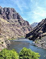
Through Hells Canyon to the mouth
Near the town of Huntington, the Snake River enters Hells Canyon, a steep, spectacular gorge that runs through the Salmon River Mountains and the Blue Mountains of Idaho and Oregon. Hells Canyon is one of the most rugged and treacherous sections of the Snake River and presented a major obstacle to 19th century American explorers. Within the canyon, the Snake River is dammed by Hells Canyon, Oxbow, and Brownlee Dams, which together form the Hells Canyon Hydroelectric Project. The Snake River now flows a long distance through Hells Canyon, which is one of the deepest canyons in the world at 2410 meters deep. Halfway down Hells Canyon, in one of the most remote and inaccessible sections in the Snake River's entire course, its largest tributary, the Salmon River, joins it from the east. From there, the Snake River forms the border between the states of Washington and Idaho, receiving the Grande Ronde River from the west before receiving the Clearwater River from the east at Lewiston. The Snake River is navigable only to the confluence of the Snake River and Clearwater River. The river leaves Hells Canyon, turns west, and meanders through the Palouse Hills in southeastern Washington. The four dams and navigation locks of the Lower Snake River Project have transformed this portion of the Snake River into a series of reservoirs. Near Almota the Snake River reaches its northernmost point, from there it flows southwest again until it finally joins the Columbia River after a total of 1735 km at Burbank east of the Tri-Cities (Pasco, Kennewick and Richland). This flows for about 523 km further west into the Pacific Ocean at Astoria.
· 
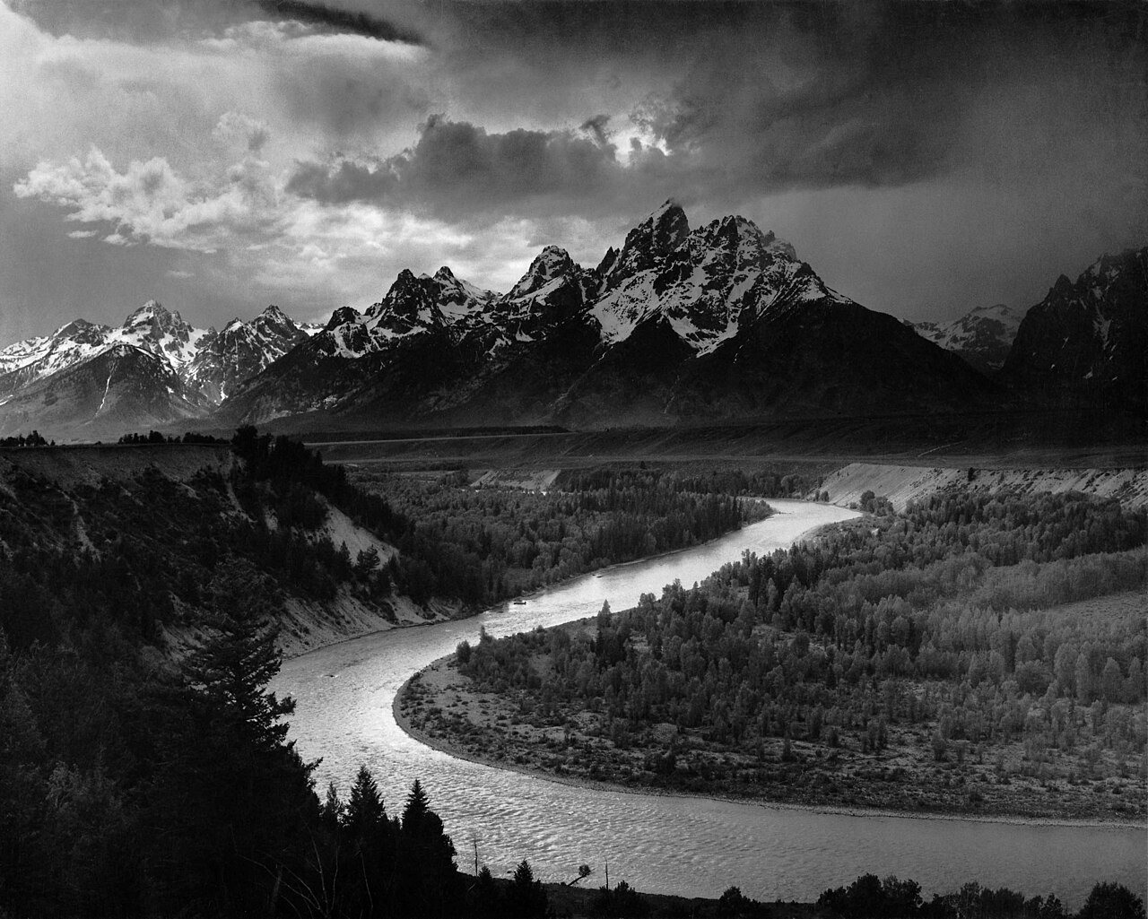
The Snake River in front of the Teton mountain range
· 
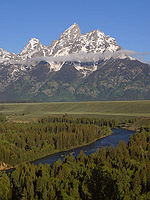
The Snake River in the Snake River Canyon (Wyoming)
· 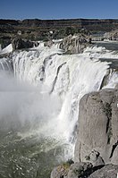
The Shoshone Falls
· 
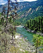
The Snake River at Hells Canyon Reservoir Dam


Geology
165 million years ago, most of western North America was still part of the Pacific Ocean. Near-complete subduction of the Farallon Plate beneath the westward-moving North American Plate created the Rocky Mountains, which were pushed upward by rising magma between the sinking Farallon Plate and the North American Plate. As the North American Plate moved westward across a stationary hotspot beneath the crust, violent lava flows and volcanic eruptions formed the Snake River Plain. This began about 12 million years ago west of the Continental Divide. Even larger lava flows over eastern Washington, consisting of Columbia River basalts, formed the Columbia Plateau southeast of the Columbia River and the Palouse Hills on the lower Snake River. Other volcanic activity formed the northwestern part of the Snake River Plain. This area is far from the path of the hotspot that now lies beneath Yellowstone National Park. At this time, the Snake River drainage basin was beginning to take shape.
The Snake River Plain and a "gap" between the Sierra Nevada and Cascade Range together formed a "moisture channel" that allowed storms from the Pacific to travel more than 1,600 km inland to the headwaters of the Snake River. As the Teton Range rose north-south along a basal thrust plane in the central Rocky Mountains about 9 million years ago, the river maintained its original course, cutting across the southern end of the mountains and forming the Snake River Canyon of Wyoming. About 6 million years ago, the Salmon River Mountains and Blue Mountains formed at the western end of the Snake River Plain, and the river also cut through these mountains and formed Hells Canyon. Lake Idaho, formed during the Miocene, covered much of the Snake River Plain between Twin Falls and Hells Canyon, but its lava dam was breached about 2 million years ago.
Lava flowing from Cedar Butte in what is now southeastern Idaho blocked the Snake River at Eagle Rock, near what is now American Falls Dam, about 42,000 years ago. This created the 64-kilometer-long American Falls Lake. The lake was stable and lasted for nearly 30,000 years. About 14,500 years ago, pluvial Lake Bonneville in what is now the Great Salt Lake area catastrophically flooded down the Portneuf River into the Snake River as part of the Bonneville Flood. This was one of the first of the catastrophic floods known as Ice Age Floods in the Northwest.
The flood caused American Falls Lake to breach its natural lava dam, which quickly eroded, leaving only the 50-foot-high American Falls at the end. The Lake Bonneville flood, about 140,000 m³/s, swept down the Snake River throughout southern Idaho. For miles, the floodwaters destroyed soils, scoured the underlying basaltic rock, and transformed the region into Channeled Scablands that formed the Snake River Canyon. Shoshone Falls, Twin Falls, Crane Falls, Swan Falls, and other waterfalls were formed along the Idaho section of the Snake River. The Bonneville flood continued to follow the course of the Snake River through Hells Canyon, eventually reaching the Columbia River. The flood widened Hells Canyon but did not deepen it.
As the Bonneville floods were rushing down the Snake River, the Missoula floods were occurring further north at the same time. These occurred more than 40 times from 15,000 years ago to 13,000 years ago. They were caused by glacial Lake Missoula on the Clark Fork, which was repeatedly filled in by ice dams and then breached, with the lake's waters causing massive flooding that affected much of eastern Washington. The Missoula floods were far greater than the Bonneville floods. These floods pooled behind the Cascade Range, forming huge lakes and carving deep canyons through the Palouse Hills, including the Palouse River Canyon with Palouse Falls. The Bonneville floods and the Missoula floods helped widen and deepen the Columbia River Gorge, a huge rocky gorge that allows water from the Columbia and Snake rivers to flow directly through the Cascade Range to the Pacific Ocean.
The massive amounts of sediment deposited by the Bonneville floods in the Snake River Plain also had a lasting effect on the middle Snake River. The high hydraulic conductivity of the mostly basaltic rocks in the Plain led to the formation of the Snake River Aquifer, one of the most productive aquifers in North America. Many rivers and streams that flow toward the Snake River from the north side of the Plains sink into the aquifer instead of flowing into the Snake River. These streams are also called the Lost streams of Idaho. The aquifer fills with nearly 120 km³ of water, and in places the water leaves the rivers at rates of up to 17 m³/s. Much of the water that the Snake River loses when it cuts through the Snake River Plain is added back to the river at its western end, for example through artesian wells.


Related articles
Author
AlegsaOnline.com Snake River (northwestern United States) Leandro Alegsa
URL: https://en.alegsaonline.com/art/91295