
Snake River Plain
A broad volcanic and river valley across southern Idaho formed by hotspot volcanism; notable for basaltic geology, a large aquifer, fertile soils, irrigation agriculture, and links to Yellowstone.
Overview
The Snake River Plain is a broad, low-lying corridor that extends across much of southern Idaho and is carved and traversed by the Snake River. It functions as both a geographic valley and a distinct volcanic province: a sequence of lava plains, caldera remnants, river terraces, and sedimentary basins. The plain is one of the most important agricultural and hydrological regions in the state, supplying water and fertile land for crops and livestock.
Image gallery
8 Images




Geology and formation
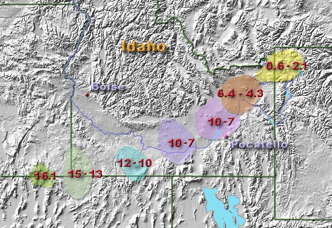
Geologically, the Snake River Plain records the passage of a volcanic hotspot beneath the North American Plate. Magma rising from the mantle produced repeated episodes of volcanic activity that created extensive basaltic lava flows, ash deposits and, in places, caldera collapse structures. Over time the moving plate left a chain of volcanic centers that trend toward the present position of the Yellowstone volcanic system. The alternating layers of lava, ash and eroded sediments form the bedrock and near-surface deposits that define the plain today.
Landscape, soils and hydrology
The plain's surface is a mosaic of flat lava fields, loess and alluvial soils, river-cut canyons, and irrigated farmland. Underlying much of the plain is a permeable basalt aquifer often called the Snake River Aquifer, which stores and transmits groundwater recharged by precipitation and by the river itself. The interaction of surface water and groundwater, plus inflow from many smaller tributaries, sustains streamflows and supports irrigation systems that are critical to the region's economy. Weathering of basalt and wind-deposited silt has produced fertile soils that favor crops such as potatoes, sugar beets, grains and hay.
Human uses and ecology
Since Euro-American settlement the Snake River Plain has been shaped heavily by agriculture, irrigation districts, and dams. Irrigated farming, ranching and associated towns rely on the plain's water and soils. At the same time the region supports native grasslands, riparian corridors and reservoirs that provide habitat for fish and birds. Recreation — boating, fishing, hiking and sightseeing — is tied to both the river and geologic features. Urban centers and transportation routes also follow the corridor where the plain provides relatively gentle terrain.
Notable distinctions and facts
- The plain is geologically young in large part because of recent volcanic activity related to the hotspot track; many lava flows are relatively recent in geologic terms.
- It contains important groundwater resources housed in fractured and vesicular basalt layers and in valley-fill sediments.
- Linkages to broader regional geology connect the plain to the Yellowstone volcanic region and to broader tectonic forces beneath western North America (regional maps, state resources).
For further orientation and detailed maps, consult regional geology guides and hydrologic studies that describe the plain's volcanic history, water systems and land use patterns (maps, state pages, Idaho resources, Snake River information, geothermal processes, aquifer studies, tributary data, soil surveys).
Related articles
Author
AlegsaOnline.com Snake River Plain Leandro Alegsa
URL: https://en.alegsaonline.com/art/91294