British Columbia
![]()
This article describes the Canadian province. For the British Crown Colony of the same name, see British Columbia (colony).
British Columbia [ˌbɹɪtɪʃ kəˈlʌmbiə] (also known as BC for short; French Colombie-Britannique), British Columbia in German, is a Canadian province on the coast of the Pacific Ocean. The province's name is derived from the Columbia River. British Columbia borders the U.S. state of Alaska to the northwest, the Canadian territories of Yukon and the Northwest Territories to the north, the province of Alberta to the east, and the U.S. states of Washington, Idaho, and Montana to the south. The capital is Victoria.
With an area of 944,735 km², British Columbia is the third largest province after Quebec and Ontario. The 2016 census counted 4,648,055 inhabitants, representing 13.22% of Canada's population and a population density of 5.0 inhabitants per km². The majority of the population lives in the southwestern part of the province. By far the largest city and also the largest economic centre is Vancouver. With the exception of the Lower Mainland and the southeastern tip of Vancouver Island, the rest of the province, which is characterized by numerous mountain ranges, is sparsely populated.
The first traces of human settlement date back almost 13,000 years. Among the First Nations, a distinction is made between numerous groups belonging to the coastal and inland Salish, Kwakwaka'wakw and Nuu-chah-nulth in the south of the province and on Vancouver Island. Further north, the Haida live on Haida Gwaii, Tlingit, Tsimshian and Gitxsan on the coast, Tagish, Southern Tutchone and Tahltan in the northern interior. In the southeast, the Kutenai are added, forming a separate language group. About 200 tribes are distinguished by the government, to which about 130,000 Indians belong. The vast majority of the population is of European descent, and there are also about half a million Chinese living in the southwest.
Contact with Europeans at the end of the 18th century led to heavy population losses among the aborigines, mainly due to smallpox epidemics, to intensive trade in furs, and to clashes between Russians, Americans, Spaniards and British. The latter founded the provincial capital of Victoria in 1843 as a fort of the Hudson's Bay Company, the dominant trading company in the West from 1821 to 1871. In 1871 the province joined Canada, which had been formed four years earlier. Gold discoveries attracted numerous immigrants between 1858 and 1898. The transcontinental railroad, which spurred Vancouver's development as a commercial metropolis, provided eastward access across the Rocky Mountains. The province's economic structure was initially heavily focused on the exploitation of natural resources, but recent decades have seen diversification.
Geography
Extent and structure
The area of the province is 944,735 km2, the length of the coastline is about 7000 km. This is due to the rugged coastline, which is characterized by numerous fjords and offshore islands. The largest island by far is Vancouver Island, which is separated from the mainland by the Queen Charlotte Strait, the Strait of Georgia and the Juan de Fuca Strait. With a length of over 450 km, a width of about 100 km and an area of 32,134 km2, it is the eleventh largest island in Canada. North of it lies the Haida Gwaii Archipelago (formerly the Queen Charlotte Islands) with a total area of 10,180 km2. In total, the province has 11,890 islands.
The capital of the province is Victoria on the southeastern tip of Vancouver Island. The most populous city is Vancouver in the southwest of the mainland part of the province, the Lower Mainland. The 49th parallel has formed the southern border with the United States since 1846, the 60th parallel the border with Yukon and the Northwest Territories, and the Continental Divide partially the border with Alberta. Although located south of the 49th parallel, the southern tip of Vancouver Island also belongs to British Columbia, but not the Point Roberts peninsula, which can only be reached from Canadian soil.
Geology and landscape
Through most of the province run various mountain ranges that folded up during the Cretaceous period. During the Worm Ice Age, all of British Columbia was glaciated except for the Haida Gwaii archipelago and small areas on Vancouver Island. In the eastern half of the province run four parallel ranges of the Rocky Mountains. These are, from east to west, the Continental Ranges, the Purcell Mountains, the Selkirk Mountains, and the Monashee Mountains, which unite in the north to form the Cariboo Mountains. West of these are the Central Highlands and the Coast Mountains on the Pacific coast. In the far northwest is the Elias Range with Mount Fairweather, the highest mountain in the province at 4663 metres.
British Columbia's longest river is the Fraser River. It forms a major transportation artery and drains much of the central and southern part of the province to the Pacific Ocean. Other major rivers in the south are the headwaters of the Columbia River and the Kootenay River. To the north, the Stikine River, Nass River, and Skeena River flow to the Pacific Ocean, while the Peace River flows toward the Arctic Ocean.
Long, narrow lakes stretch across the valleys of the Central Highlands. These include Kootenay Lake, Okanagan Lake, Quesnel Lake, and Shuswap Lake. Several high dams, particularly on the Columbia River, created large reservoirs such as Kinbasket Lake. The largest freshwater lake in the province is the artificially dammed Williston Lake on the Peace River. In all, British Columbia is home to 241,576 lakes, which together cover about 22,500 km2; of these, however, only 16 are larger than 100 km2.
Off the coast of the province are about 5250 smaller and larger islands. The largest and best known island is Vancouver Island. Other large islands are Graham Island, Moresby Island, Princess Royal Island, Pitt Island and Banks Island.
Climate
The northern part of the mainland is influenced by the Arctic climate and experiences cold, snowy winters. The largest amount of snow per day measured in Canada fell at Tahtsa Lake on February 11, 1999, at 145 cm. Due to the influence of the Kuroshio current in the Pacific Ocean, areas in the south and on Vancouver Island have a warm temperate climate. The west coast is very rainy. In 1967, 489.2 mm of rain fell on a single day at the Ucluelet Brynnor Mines, the highest amount ever recorded in Canada.
The inland area, which lies in the lee of high mountain ranges, can become very hot and dry in summer. In the south central highlands there are some desert-like areas; there is little precipitation and temperatures rise to over 40 °C in summer. The Okanagan Valley region is the most important wine-growing area in western Canada; it receives only 250 mm of rain per year.
flora and fauna
Hardly more than four percent of the area is suitable for agricultural use. These areas are concentrated in the south and along the river courses. Otherwise, forests dominated.
However, resource extraction and logging have almost completely eliminated the virgin forests, except for a few refuges such as the Pacific Rim National Park or Cathedral Grove and stands in the north of the province. Large parts of the west coast of Vancouver Island and the coastal region of the mainland up to the Alaska Panhandle are covered with temperate rainforest. The northern hinterland is dominated by plant communities of tree species such as black spruce, white spruce, East American larch and also fir, in addition to Douglas-fir and Sitka spruce.
In the north, especially east of the coastal mountains, and in parts of the Rocky Mountains to the east, the caribou lives only in the subspecies Woodland Caribou (Rangifer tarandus caribou) (another subspecies became extinct on Haida Gwaii in the 1920s). Estimated to number only 16,500 now, it occurs in large herds in the north, such as the Carcross/Squanga, Ibex, and Atlin herds that live in the Yukon border area. Two other types, such as the Mountain Caribou and the Boreal Caribou occur virtually only here, but in very small numbers (2500 and 725 respectively). As in all of Canada, populations are declining due to industrialization and winter recreational activities, especially disturbance by motorized sleds. The importance of hunting is declining in this regard. In addition, there are moose, referred to as moose, snow goat and Dall sheep, as well as bison and wapiti. Predators include the wolf, grizzly bear, cougar called cougar, coyote, Canadian lynx, plus the black bear as well as the orca.
Numerous rodents are represented, among them various squirrels called squirrels, gopher, mice, beaver. The latter was one of the many suppliers of fur, but the main among them are spruce marten, ermine, mouse weasel, mink, otter, but also Canadian lynx and red fox.
Over 300 bird species are native to British Columbia, about 65 of which are endemic. Among the most culturally significant for the First Nations are the raven, the bald eagle and the golden eagle. Among falcons, the peregrine falcon is notable. Among the pheasants, there are the spruce grouse and rock grouse, but also the ruffed grouse.
The most important fish are the Pacific salmon, the chinook salmon, the sockeye salmon, the chum salmon and the silver salmon. They migrate up the rivers in huge schools to spawn and in many places form the crucial basis for the ecosystems there.
Cities, towns, population distribution
→ Main article: List of municipalities in British Columbia
British Columbia has only a few metropolitan areas. Every second resident of the province lives in the Metro Vancouver metropolitan area, which, in addition to Vancouver itself, is made up of several independent municipalities. The largest cities by population, according to the 2006 and 2011 censuses, were:
|
|
The following map and 2006 Census results for the 26 Census Agglomerations show how unevenly the population is distributed:
|
|
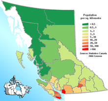
Population density
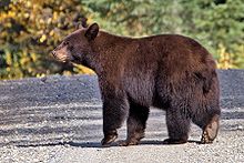
Black bear at Quesnel Lake
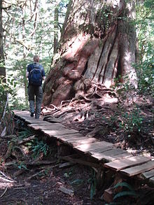
Huge trunk of a giant tree of life on Meares Island
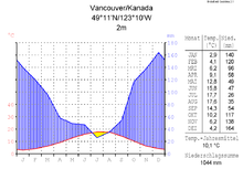
Vancouver temperature and precipitation
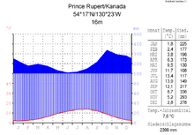
Prince Rupert
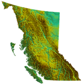
Relief of the province
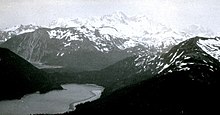
Mount Fairweather
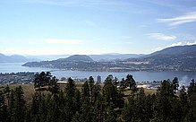
Lake Okanagan
History
→ Main article: History of British Columbia
Early history
See also: History of the Coast Salish and History of the First Nations
The oldest traces of human presence were estimated at 12,500 years until a 14,000-year-old settlement site was found on Triquet Island. They indicate that the coast of the province was of great importance for the southward migration of Indian groups, especially since it remained partially ice-free even during the last ice age.
Especially on the coast, the supply for the slowly growing communities was secured by the wealth of marine mammals, fish and game, but also of materials such as wood and wood fibres, berries and grass. On this basis, complex, hierarchical social systems developed early on, with outstanding cultural works - the totem poles and the masks are famous. Large villages, permanently inhabited in winter, and plank houses were characteristic; the most important domestic animal was the dog, which served as a guardian and whose hair was made into textiles. Specific groups can be identified early on, to which on the coast can be traced the Tsimshian, Tlingit, Nuu-chah-nulth, Kwakwaka'wakw, and Coast Salish. Whale hunting exclusively characterized the culture of the Nuu-chah-nulth on the west coast of Vancouver Island.
The oldest find from the Northwest comes from a cave in the Tongass National Forest (discovered in 1996) on Prince of Wales Island and is dated to be 10,300 years old. Finds on the lower Fraser River and on Vancouver Island date from the same period.
In the hinterland extended the cultural area of the plateau, which in British Columbia means the Fraser Plateau. Stockpile houses enabled discernible population growth from about 2000 BC, with which large villages can be associated, some of which have more than a millennium of continuous use. Dominant here were inland Salish groups and Kootenay, but Eyak-Athapascan speakers, such as Chilcotin and Dakelh, arrived around 500 BC. Life in the drier hinterland was only partially based on fishing. Here, hunting and gathering became more important.
The north, on the other hand, belongs to the sub-Arctic cultural area, which, because of its sparse settlement, becomes graspable only very late. Here lived Taku River Tlingit, Tagish, Dease River (Tahltan) and southern Tutchone.
European trade
Although it is believed that as early as 1579 Sir Francis Drake may have explored the coast of British Columbia, it was not until 1774 that Juan José Pérez Hernández made the first documented voyage to look for possible Russian settlements and take possession of the land for Spain. Juan Francisco de la Bodega y Quadra's expedition followed a year later. Beginning in 1775, perhaps a third of the native population fell victim to a smallpox epidemic introduced by the Spanish.
In 1778, the Briton James Cook reached the coast in search of the Northwest Passage and came into contact with the Nuu-chah-nulth at Nootka Sound. Subsequently, a brisk fur trade with China developed, organized by the British. Conflicts arose between Britain and Spain over influence in the Pacific Northwest, which was peacefully settled in 1794. George Vancouver was busy surveying the area at the time.
In 1793, Alexander Mackenzie, a member of the North West Company, became the first European to reach the coast from the east. Mackenzie's companion John Finlay established Fort St. John, the first permanent European settlement in British Columbia, in 1794. Simon Fraser explored much of the interior along the stream named for him in 1808. In 1811 David Thompson explored the entire length of the Columbia River. These voyages were not undertaken for political reasons, but primarily to find new trade routes.
South of the Russian-American border (54°40' N), the Hudson's Bay Company (HBC) and the American Fur Company were active in the fur trade, in addition to the North West Company. Britain and the United States entered into the Treaty of London in 1818, which provisionally governed the sharing of what was then called Oregon Country by the Americans and the Columbia District by the British. After the merger of the HBC and North West Company in 1821, the territory of what is now British Columbia was divided into three trading districts. The northern and central portion of the interior formed New Caledonia (administrative seat Fort St. James). The interior south of the Thompson River watershed and north of the Columbia River was part of the Columbia District, with Fort Vancouver as its administrative centre. The extreme northeast, known as the Peace River Block, was part of the Athabasca District administered from Fort Chipewyan in Alberta.
British seizure
Until 1849, these trading districts were territories in British North America under the de facto jurisdiction of the HBC administrators. Unlike Rupert's lands to the north and east, the districts were not Company leaseholds. Here, the HBC merely held a monopoly on trade with the native peoples and was not, for the time being, interested in colonization. However, this changed in the 1840s as the United States extended its sphere of influence further and further west. This led to overlapping territorial claims, especially on the lower reaches of the Columbia (in what are now the states of Washington and Oregon).
To secure British claims, Fort Camosun was built on Vancouver Island in 1843, from which the city of Victoria later developed. In 1846, Great Britain and the USA established the 49th parallel as their common border with the Oregon Compromise, and Vancouver Island and the Gulf Islands, which protruded further south, became entirely British property. In 1849, the Crown Colony of Vancouver Island was established, with Victoria as its capital. New Caledonia, as the entire mainland part of the later province was now called, remained a territory under the informal administration of the HBC.
Gold discoveries and mass immigration
When Governor James Douglas shipped a load of ore to San Francisco for assaying in 1858, it was discovered that this ore, mined north of Yale on the Thompson River, contained gold. This discovery sparked the Fraser Canyon Gold Rush, and Victoria was transformed into a big tent city in short order. Thousands of (mostly American) prospectors, speculators, agents and traders moved here. The HBC's Fort Langley served as a base for many prospectors, although Governor Douglas had only allowed access through Victoria. Tensions arose between prospectors and Nlaka'pamux and eventually the Fraser Canyon War.
At the beginning of the gold rush, the mainland was not yet under formal administration of the British state. Faced with the presence of thousands of Americans, Douglas feared for the loss of British influence. A gunboat he requested enforced royalties on the Fraser River for boats and ships that wanted onto the river. The British Colonial Department finally declared the mainland portion a crown colony of British Columbia on August 2, 1858, with New Westminster as its capital. Douglas was appointed governor of both colonies.
No sooner was the Fraser Canyon gold rush over than gold was discovered again further inland. During the Cariboo Gold Rush of 1861/62, tens of thousands of people flocked to the Barkerville and Lillooet area. It was they who introduced diseases unknown to the Indians, against which there was almost no resistance. In 1862, about half of the Indians in the West and Northwest died from a devastating smallpox epidemic.
To facilitate access for Europeans and to better control the Cariboo area, the colony's government had the Cariboo Road (also called the Cariboo Wagon Road or Great North Road) built. It used the revenue from royalties to fund the provision of basic infrastructure in the rapidly growing gold towns. However, the government was running a large deficit. Therefore, to save money, the two colonies were merged on August 6, 1866 to form the United Colonies of Vancouver Island and British Columbia, with Victoria as the capital.
Connection to Canada
The decline in economic power after the end of the gold rushes, as well as the desire for self-government and a self-reliant government, led to the formation of a political movement calling for the colony to join the Canadian Confederation, which had been formed in 1867 from the union of three British colonies in the east of the continent. In particular, the Confederation League, led by three later prime ministers, Amor De Cosmos, John Robson and Robert Beaven, championed this cause. Crucial, however, was the support of John Sebastian Helmcken. Their main arguments were the fear of a possible annexation by the USA and the large deficit due to the strong population growth - after all, in 1871 the population was estimated at 60,000.
On July 20, 1871, British Columbia finally became the sixth province to join Confederation. In return, the Canadian state undertook to assume the debt and promised to build the Canadian Pacific Railway within ten years. However, the fulfillment of this promise was delayed. It was not until November 7, 1885, when the symbolic "last nail" was set in Craigellachie, that the transcontinental railway was completed.
Favoured by the easier accessibility, numerous coal and iron ore mines as well as ironworks were established, especially in southeastern British Columbia. Several new towns were founded near them. In addition to mining, forestry, agriculture and fishing began to play a significant role, and the prospect of job opportunities attracted many immigrants. The economic boom encouraged the development of the old fur trading posts (such as Victoria, Nanaimo, Prince George, Kamloops, and Fort St. John) into large cities. Vancouver, however, developed into the colony's largest city. Vancouver owed its rapid rise primarily to the fact that the Canadian Pacific Railway moved its western terminus here in 1887 and that extensive port facilities could be built here from which the province's mineral resources could be exported.
Industrialization, immigration, political parties
It was not until 1903 that the borders of the province were finally fixed. In 1825, Great Britain and Russia had established the boundary between their possessions in a treaty, but the wording was kept very vague. When Alaska was purchased by the US in 1867 and British Columbia joined Canada in 1871, Canada demanded a survey of the Alaska Panhandle, but the US refused on cost grounds. In 1903, U.S. Secretary of State John Hay and British Ambassador Michael H. Herbert negotiated a compromise. Since then, the border has run roughly down the middle of each other's territorial claims.
The exploitation of natural resources required a large labor force, which, under the conditions of the time, amounted to a large number of immigrants, because the labor pool of Indians and early settlers was far too small. Immigrants, however, came not only from Europe, but increasingly from China, British India, and Japan, which often led to racial attacks. On a political level, the immigration of non-European people was increasingly restricted. The enactment of the Chinese Immigration Act 1923 made the immigration of Chinese practically impossible (only traders and investors were exempt).
In 1914, the Grand Trunk Pacific Railway, a second transcontinental railway line, was completed. It ran through the north of the province from Yellowhead Pass via Prince George to Prince Rupert. This line enabled the economic development of the previously sparsely populated region.
In 1917, alcohol prohibition came into effect, but was repealed as early as 1921, as it could not be enforced due to black market trade and rampant corruption. As the production and sale of alcohol remained prohibited in the bordering United States, a thriving alcohol industry developed in British Columbia, bringing its products across the border through smuggling. The Great Depression plunged the province's economy into a deep recession beginning in 1929.
With the outbreak of the Second World War, there was a strong growth in the armaments industry. This, along with increased demand for raw materials, led to a rapid economic boom. In 1942, a few months after the attack on Pearl Harbor, the Canadian government considered Japanese Canadians to be a threat to national security, much as the Germans had been in the First World War. They were dispossessed, rounded up, and then interned in inland camps. It was not until 1988 that the Canadian government officially apologized and made compensation payments. The post-war period saw a change in provincial politics. The previously dominant Liberals and Conservatives suffered a heavy defeat in the 1952 election and sank into irrelevance. Under Premier W. A. C. Bennett, the British Columbia Social Credit Party rose to become the strongest party. During Bennett's twenty years in government, British Columbia experienced an unprecedented economic boom. Apart from a brief period of government by the British Columbia New Democratic Party (NDP) from 1972 to 1975, the Social Credit Party remained in power until 1992. However, due to numerous political scandals during Bill Vander Zalm's reign, the Social Credit Party completely collapsed. Its voter base turned almost entirely to the resurgent British Columbia Liberal Party, which has been in government since 2001, after an equally scandal-ridden and economically depressed ten years of NDP government. The Liberal government sought to privatize Crown land and to this end initiated the so-called Working Forest Plan, which envisaged the economic exploitation of all forest areas located on this land. However, it failed for the time being in 2004 due to the resistance of numerous residents.
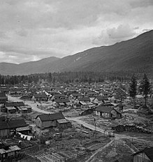
Internment camp for Japanese, June 1945
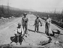
In 1933, attempts were made to employ men in road construction - only in exchange for room and board - as here at Kimberly-Wasa. This led to protests in 1934.
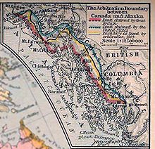
Territorial claims in the Alaska Panhandle Red: Western border claimed by Great BritainBlue : Eastern border claimed by the U.S.A.Yellow : Present-day border demarcation
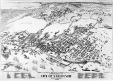
View of Vancouver in 1898
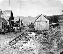
Gold mining town of Barkerville (1865)
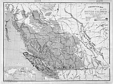
Map of British Columbia from 1873, showing the province's natural resources.
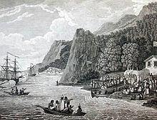
John Meares' expedition arrives at Nootka Sound in 1788
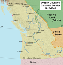
Map of the Oregon Country showing British and American territorial claims.
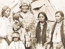
Members of the Nlaka'pamux, ca. 1914
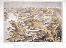
Advertising poster for the "new Eldorado", 1858
Questions and Answers
Q: What is British Columbia?
A: British Columbia is a province in Canada.
Q: How did British Columbia come into being?
A: British Columbia was originally two separate colonies of Great Britain, the colony of Vancouver Island, and the colony of British Columbia.
Q: When did British Columbia join the Canadian Confederation?
A: British Columbia joined the Canadian Confederation in 1871.
Q: What is the capital of British Columbia?
A: The capital of British Columbia is Victoria.
Q: Which city in British Columbia has the highest population?
A: The city with the most people in British Columbia is Vancouver.
Q: What is the history of Vancouver Island?
A: Vancouver Island is one of the two original colonies of Great Britain that make up British Columbia.
Q: What is the history of British Columbia?
A: British Columbia was formed from two separate colonies of Great Britain, Vancouver Island and British Columbia, and joined the Canadian Confederation in 1871.
Search within the encyclopedia