
Avarua — capital town and district on Rarotonga, Cook Islands
Avarua is the national capital and principal settlement on Rarotonga, Cook Islands. This article describes its geography, economy, services, market culture, transport links and local features.
Overview
Avarua is the administrative centre and largest town on the island of Rarotonga in the Cook Islands. Its location is often indicated by its coordinates. Commonly described as both a town and a district, Avarua functions as the national capital of the Cook Islands. The place-name comes from Cook Islands Māori and is usually translated as "Two Harbors," reflecting its coastal setting and historic anchorage points (Two Harbors).
Image gallery
8 Images


Geography and setting
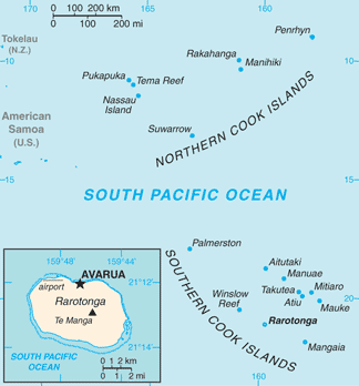
Avarua sits on the northern shore of Rarotonga (Rarotonga), the largest of the Cook Islands group. The downtown area lies at sea level and is sheltered by the island's central ridge, whose highest points reach roughly 208 m (about 682 ft). The town is part of the island landform (island) and benefits from lagoon waters and reef protection, shaping its coastal roads and harbours.
Economy, population and transport
Residents of Avarua earn income from several activities: tourism is the dominant sector, supported by local trade, commercial fishing and small-scale agriculture. The town is served by Rarotonga International Airport and the main urban artery, Ara Maire Nui (commonly called Marine Drive or Main Street), which connects to the island-circling ring road Ara Tapu. In the early 21st century the local population was recorded at several thousand, concentrated around the central business area and surrounding villages.
Services, markets and local life
Avarua provides the primary retail, banking and administrative services on the island: there are multiple supermarkets, at least two banks, and a variety of restaurants and small shops. Markets and handicraft stalls sell traditional goods such as black pearls and other handicrafts. A popular open-air market operates on Saturdays (market, Saturday), offering colourful pare'u or wrap dresses (pare'u), floral garlands (flowers), freshly caught fish and a selection of tropical fruits.
Characteristics and notable facts
- Administrative functions concentrate in the town centre, where government offices and community services are located.
- Avarua combines modern conveniences with a small-town Pacific character: shops, eateries and informal markets sit alongside family homes and village halls.
- Its coastal position and road links make Avarua the island's hub for inter-island transport, commerce and cultural events.
Practical information
Visitors typically pass through Avarua when arriving or leaving Rarotonga, using local transport to reach accommodations and attractions. The town is compact and walkable, with main services concentrated along Marine Drive and adjacent streets. For further local information, maps and schedules, many travellers consult official and community resources before arrival (coordinates, Rarotonga, Cook Islands).
Additional references and links to local topics: Island geography, place name meaning, national capital, downtown area, sea level note, altitude, altitude (ft), supermarkets, banks, restaurants, black pearls, handicrafts, open market, market day, pare'u, flower garlands, fresh fish, tropical climate, fruits, tourism economy, trade, Ara Maire Nui.
Related articles
Author
AlegsaOnline.com Avarua — capital town and district on Rarotonga, Cook Islands Leandro Alegsa
URL: https://en.alegsaonline.com/art/7685
Sources
- epress.lib.uts.edu.au : "Hassall"