
Sea level: definition, measurement, and significance
Sea level is the average surface height of the ocean used as the reference for elevation. This article explains mean sea level, how it is measured, what causes it to change, and why it matters.
Sea level is the average height of the ocean's surface used as a baseline for measuring land elevation and depth. Because the water surface rises and falls with tides, weather and currents, the term usually refers to a statistical average such as mean sea level. For discussions of how a warming climate affects ocean height, see global warming.
Image gallery
10 Images




Definition and variability
Mean sea level is computed from long-term observations at specific locations and is adjusted to remove predictable cycles such as daily tides. Local sea level may differ from a global average because of ocean circulation, atmospheric pressure, and changes in the shape or level of the land beneath the water. Short-term changes include tidal ranges and storm surges, documented at tide gauges and in coastal records; for basic tide concepts see tides.
How sea level is measured
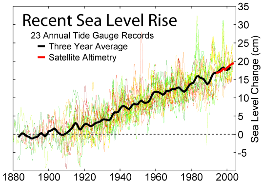
Measurements come from two principal sources: shoreline tide gauges and satellite altimetry. Tide gauges record water height relative to a nearby land benchmark over decades or centuries; satellite instruments measure the height of the sea surface across the globe. Geodesists tie those measurements to vertical reference systems so heights of features such as mountain elevations and the positions of countries can be compared.
Causes of change
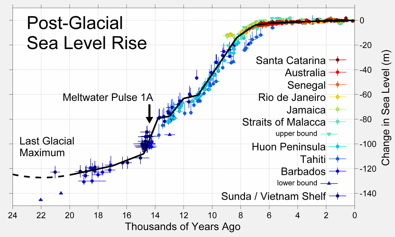
Sea level changes for several reasons. Global (eustatic) changes reflect the volume of the oceans — driven by melting ice and thermal expansion of warmer water — processes linked to climate change. Local (relative) changes can be caused by land uplift or subsidence, sediment compaction, or shifts in ocean circulation. Long-term geological effects such as post‑glacial rebound also alter regional sea levels.
Uses and importance
Sea level serves as the standard vertical datum for mapping, construction, aviation, and navigation. It is essential for coastal planning, flood risk assessment, and habitat conservation. Planners rely on records of historical sea level and projections to design defenses and manage land use. Important technical references and baseline data are maintained by national and international agencies and accessible through oceanographic repositories and the wider scientific literature; see related oceanography resources at ocean and measurement guides at reference.
Notable distinctions
- Mean vs. instantaneous: instantaneous sea level includes waves and tides; mean values smooth those fluctuations.
- Relative vs. absolute: absolute (geocentric) sea level refers to the ocean surface in a fixed Earth-centered frame, while relative sea level is measured at a particular shoreline.
- Regional variation: patterns of wind, temperature and salinity produce differences between regions even when global averages change.
Understanding sea level requires combining observations, models and an appreciation of local geological context. Ongoing measurements continue to refine how scientists and societies interpret changes and plan for coastal resilience.
Questions and answers
Q: What is the sea level?
A: The sea level is the average height of the ocean or the height of the ocean's surface from another point of reference.
Q: What causes changes in the sea level?
A: The sea level changes with the tides and weather events such as tsunamis, hurricanes, and cyclones. Additionally, global warming causes the sea level to rise.
Q: What does the word "average" mean when talking about the sea level?
A: The word "average" is used when talking about the sea level because the height of the sea changes with the tides.
Q: How is the height of mountains and countries given?
A: The height of mountains, countries, and so on is almost always given as "above sea level."
Q: What is global warming's effect on sea levels?
A: Global warming causes the sea level to rise due to melting ice caps and glaciers, and the expansion of seawater as it warms.
Q: Can weather events like tsunamis cause changes in the sea level?
A: Yes, weather events such as tsunamis, hurricanes, and cyclones can cause changes in the sea level.
Q: What is the difference between sea level and above-sea-level measurements?
A: Sea level is the average height of the ocean, while above-sea-level measurements refer to the height of other land features such as mountains, countries, and so on.
Related articles
Author
AlegsaOnline.com Sea level: definition, measurement, and significance Leandro Alegsa
URL: https://en.alegsaonline.com/art/88266
Sources
- straightdope.com : What is "Mean Sea Level"?
- ipcc.ch : Technical Summary, Section 3.4 Consistency among observations
- ipcc.ch : Executive summary, Section 1.3: Consistency of changes in physical and biological systems with warming
- ui.adsabs.harvard.edu : 2008Sci...319.1357M
- doi.org : 10.1126/science.1151540
- pubmed.ncbi.nlm.nih.gov : 18323446
- linkinghub.elsevier.com : "A new chronology for the middle to late [[Miocene]] continental record in Spain"
- ui.adsabs.harvard.edu : 1996E&PSL.142..367K
- doi.org : 10.1016/0012-821X(96)00109-4
- grida.no : "Climate change 2001: the scientific basis. Can 20th century sea level changes be explained?"