Road (transport infrastructure)
A road is a prepared route across land for people and vehicles. This article explains types, materials, history, management, uses, and differences from waterways and railways.
Overview
A road is a prepared route that connects two or more places to enable movement of people, goods and services. Roads vary in size and purpose, from simple rural tracks to multilane urban highways. They are designed to make travel easier by shaping the landscape—removing obstacles such as trees and stones, grading the surface to be more level, and adding materials that suit the expected traffic.
Image gallery
10 Images


Materials and structure
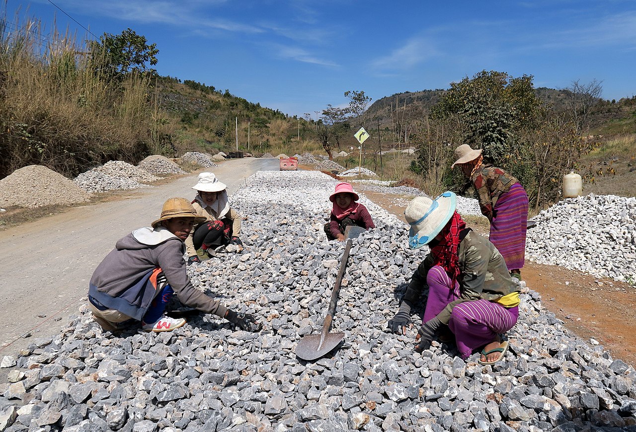
Traditional and modern roads use a mixture of natural and manufactured materials. Common surfacing and base materials include gravel, compacted dirt, asphalt, and cementitious pavements such as concrete. In some historic or decorative contexts, brick or dressed stone is used. The choice of material depends on climate, expected loads, available resources and maintenance regimes. Many roads have layered construction: a prepared subgrade, a compacted base, and a wearing surface designed to resist rutting, erosion and weather.
Types and characteristics
- Local streets and lanes: low-speed routes serving neighborhoods and rural properties.
- Collector and arterial roads: connect local streets to higher-capacity routes.
- Highways and motorways: designed for high-speed, long-distance travel with controlled access.
- Specialized tracks: for agricultural, industrial or recreational use.
Most modern roads are dimensioned for wheeled vehicles such as bicycles, cars and trucks, but they also serve pedestrians, horses and other local uses where relevant.
History and development
People have built roads for millennia. Examples often cited in studies of early road systems include Roman roads in Britain and the extensive Inca network in South America referenced as the Inca road system. Historically, moving heavy goods by Transport on a waterway was frequently easier than overland, but roads remained essential for inland access. The industrial era introduced mechanized vehicles and railways, which use dedicated railway tracks and complemented road networks rather than replacing them entirely.
Management, funding and issues
Construction and upkeep of roads are typically public responsibilities funded by general revenue such as taxes, although some are financed through user charges. Toll roads collect fees directly from drivers to cover construction or maintenance costs. Common operational challenges include surface deterioration, winter weather damage, and traffic congestion. Authorities address congestion with measures such as road widening, traffic management systems, public transport investment, and land-use planning.
Importance and notable distinctions
Roads are a core element of modern infrastructure: they enable commerce, emergency response, social access and tourism. Unlike waterways and railways, roads offer flexible routes and door-to-door access for a wide variety of vehicles. Distinctions within the category—such as rural track versus controlled-access highway—affect design, safety standards and funding models. Understanding these differences helps planners balance mobility, environmental impact and long-term maintenance needs.
Further reading: For technical standards, planning guidance and case studies, consult transportation or civil engineering references and local highway authorities.


General
Roads are generally understood to mean streets, roads and squares dedicated to public traffic. In particular, a street includes:
- the body of the road:
- Subgrade - the natural rock or soil on which the road body is built.
- Substructure - artificially produced dam body between subgrade and superstructure, not used in cuttings
- Superstructure - consists of one or more base courses and the road surface.
- Earthworks - dams, ditches, embankments, berms
- Structures - culverts, drainage systems, retaining walls, bridges, tunnels, noise protection systems
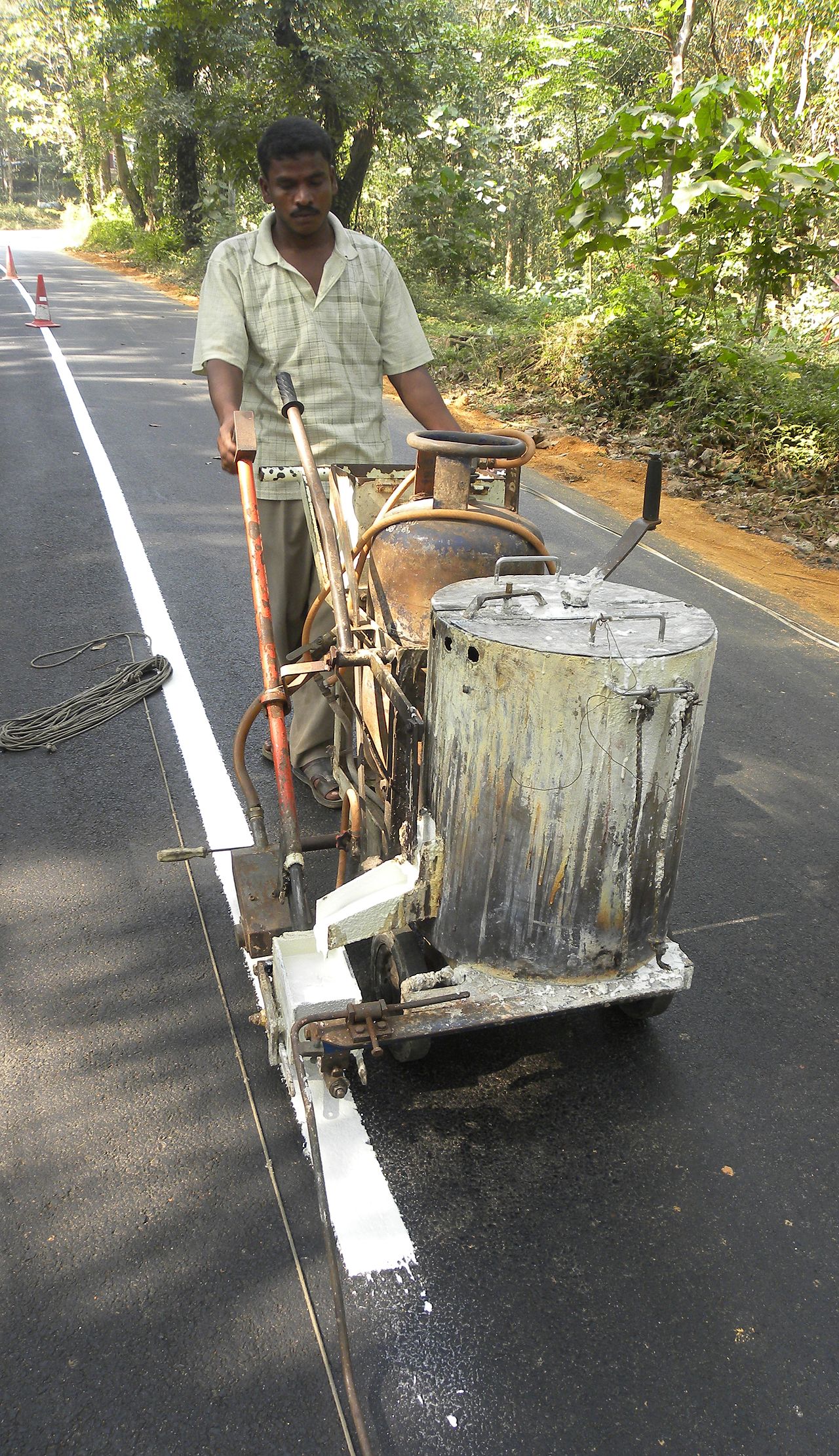
- Road surface - with road markings and signage
- hard shoulders and verges
- the airspace above the road body
- the accessories:
the official traffic signs, traffic facilities and other installations which serve the safety, order and ease of traffic and the protection of residents, e.g. delineators, lighting, traffic lights, crash barriers, road markings and planting
- the ancillary facilities:
the road maintenance depots, equipment yards, storage yards, deposition and extraction points, ancillary establishments and facilities
Legally, the entire public realm constitutes the road. For example, the term "cycling on the road" is misleading in that it includes the pavement. Pedestrians, cyclists and motor vehicles all move along the road.
Traffic Separation:
- motor vehicle traffic - it moves exclusively on the carriageway
- other vehicle traffic - on the carriageway or, in the case of bicycles, on the cycle path
- Pedestrians - On the sidewalk (if available), otherwise on the roadway.
Notation
Even after the 2006 spelling reform, only the spelling with "ß" is correct in Austria and Germany: "Straße". In many places you can find the wrong spelling "Strasse" according to both the current and the old rules. There, when using capital letters, "STRASSE" is correct.
In Switzerland and Liechtenstein, on the other hand, "road" is the correct term and is officially designated as such.
Components of the road cross-section
→ Main article: Road cross-section
A road cross-section should guarantee traffic safety without compromising performance, the objectives of environmental protection and urban development must be taken into account, and economic efficiency must be guaranteed.
Depending on the required function, the road cross-section is composed of the following elements:
- Roadway - divided into lanes and shoulder,
- Walking and cycling facilities, together or separately
- Parking areas
- hard shoulder
- Separation strips - divided into middle strips and side separation strips,
- Banquets
- Shelves and drainage channels
Building materials
The road surface is made of asphalt concrete, cement concrete, pavement or unpaved material (for example, crushed stone).
Traffic types and usage requirements
There are different uses for the traffic area, which is why different areas are established on roads. These include:
- Roadway
- verges, dividing strips, paved verges, verges,
- Bicycle paths and sidewalks,
- Stops, parking lots, parking bays and rest areas as well as the areas of traffic-calmed down areas.
The term paths is used to describe roads designed exclusively for non-motorised traffic. An exception here are the so-called rural roads. These are also designed for motorised traffic in agriculture and forestry.
In the area of roads and paths, a further distinction is made between the open road, the local road, the junction and the ancillary facilities.
Traffic capacity
The traffic capacity of a road depends to a large extent on its state of development (number and width of lanes, routing). In addition, town crossings with numerous junctions and intersections, railway crossings and the terrain topography (gradient/slope) also play a role. The share of truck traffic is also important. The higher the proportion, the lower the number of vehicles that can use the road in total without the traffic flow coming to a standstill. In Germany, two sets of rules define the construction standards for roads outside built-up areas. For motorways these are the Guidelines for the Construction of Motorways and for federal, state and local roads the Guidelines for the Construction of Rural Roads. They define the maximum capacity of a two-lane road at around 20,000 vehicles per day, although traffic congestion can already accumulate at traffic volumes above 10,000 vehicles per day - for example in intersections, with slow trucks and a lack of overtaking opportunities or at level crossings - and an expansion, e.g. in the 2+1 system or by converting intersections to height-free entrances/exits, can make sense. Two lanes per direction, a total of four lanes, are the standard for motorways and highly frequented sections of trunk roads with traffic densities of between 20,000 and 60,000 vehicles per day. Three lanes per direction (six lanes total) should be applied for traffic volumes between 60,000 and 100,000 vehicles per day, which applies to higher volume freeway segments. Traffic volumes above 100,000 vehicles per day only occur on the main motorways in conurbations and necessitate the creation of additional directional lanes.
Road categories
Roads are subdivided according to road categories.
These include, for example, motorways, trunk roads, main roads, local roads, access roads, play roads, agricultural and forestry roads, independently guided cycle paths, footpaths, roundabouts, tunnels or car parks. In localities, the distinction between through roads, urban roads, estate roads and residential roads is important. In Germany, the regulations of the Forschungsgesellschaft für Straßen- und Verkehrswesen (Research Society for Roads and Traffic) distinguish between main roads, collector roads and access roads in built-up areas, whereby this primarily designates the importance in the motor vehicle network.
Special categories are customs roads (duty-free roads), cul-de-sacs, one-way roads, pedestrian zones, temporarily closed or open roads, residential roads, bicycle roads, pass roads, race tracks.


Designation
Name
In Germany, inner-city streets usually have names (an exception is Mannheim city centre), which are indicated by signs at intersections or junctions. As a rule, each street name occurs only once in each town, so that the streets can be clearly identified by naming the town and the name. Due to incorporations, street names may occur more than once. As a rule, the smaller of the affected streets is then renamed. If this was omitted, as in Cottbus, street names exist several times. An exact identification is then usually possible via the district name or the postal code. With the formation of Greater Berlin in 1920, a large number of rural communities and villages in the surrounding area were included, so there were several street names with the same name, which could, however, be distinguished by the (therefore usual and necessary) indication of the administrative districts or local parts. In 1938, with the centralization of administrative functions, a major renaming campaign took place, but it did not cover all duplications. In addition, there is a large number of streets which are only distinguished by numbering - mostly according to the development plan - again partly also assigned twice. (Example: Street 101 No. 3a) Due to the subsequent war and post-war years, duplicate street names were only renamed again later and district by district; remaining examples can be found in the lists of local parts of streets and squares in Berlin. Thus, even in the 2000s, streets are renamed when prompted otherwise. Dedicated numbered streets are renamed when the occasion arises. In the meantime, the renaming of streets (especially after reunification) is coordinated between and within Berlin's boroughs. As an example, the selection of 42 streets to be renamed in Berlin-Blankenburg can be mentioned, where the plant-uniform naming according to bird species led to consideration of street names in other settlements and alternative names.
Out-of-town roads and trunk roads have numbers. In Germany, only the numbers of federal roads and motorways are normally signalled to the motorist. State roads and district roads are also marked with numbers. These numbers can be recognised by the station sign, which, however, is of no further significance to the road user.
Name additions
In the case of names for local roads, it is necessary to put the word element street. However, depending on the property, the use of other street-describing terms is common. For residential streets, the word component -weg is often used, since the authorities or residents want to distinguish the surface or width of the street from that of a city street. However, it is not usual to assign such word stock parts to traffic conditions; for example, an "X-path" may well be a road capable of carrying motor vehicles.
An example are the streets newly created in the 1960s and 1970s in Berlin-Gropiusstadt. Here (sometimes for historical reasons) trafficable streets of class V (other streets) of the Berlin street directory were named Path, Row, Steig, on the other hand Allee or Damm are leafy but narrow streets.
The following overview shows a list of the frequently occurring suffixes for street and place names in German-speaking countries:
- Street
- Gasse (also "alley" is a small, narrow street)
- Alley
- Avenue (boulevard see e.g.: Unter den Linden)
- Boulevard
- Alley
- Dam
- Path
- Place
- Promenade
- Ring
- Climb/climb
- Tweet
- Wall
- Path (see also farm track, goods road)
- Line
The following overview shows a list of the prefixes frequently used in German-speaking countries for the names of streets and squares:
- At
- On the
- In the
- At the
- At
- Main
- Country
- Church-
- Field

Questions and answers
Q: What is a road?
A: A road is a piece of land which connects two or more places, usually made easy to travel on by removing trees and stones so the ground is more level. Some roads are paved with concrete, bricks, or stones.
Q: How long have people been making roads?
A: People have been making roads for a long time. Famous examples include Roman roads in Britain and the Inca road system.
Q: How did transport used to be easier than travelling by road?
A: Transport by boats on waterways was usually easier and faster than transport by road. In the industrial revolution, the railway was invented as a special type of road using railway tracks.
Q: What are roads now usually made for?
A: Roads are now usually made for wheeled vehicles like cars to travel on.
Q: What happens when traffic congestion becomes frequent?
A: When traffic congestion becomes a frequent problem, the road may be made wider or other roads built.
Q: Who pays for building and caring for roads?
A: Road building and care is usually paid for by taxes. Some roads are toll roads where people pay to use them.
Q: What was invented during the industrial revolution that replaced travelling by boat?
A: During the industrial revolution, the railway was invented as a special type of road using railway tracks that replaced travelling by boat as an easier form of transportation.
Related articles
Author
AlegsaOnline.com Road (transport infrastructure) Leandro Alegsa
URL: https://en.alegsaonline.com/art/83214