European windstorm
Extratropical cyclones that form over the North Atlantic and commonly strike western, northern and central Europe, producing strong winds, coastal surges and recurrent socioeconomic impacts.
Overview
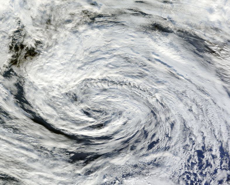
A European windstorm is a type of extratropical cyclone that forms over the North Atlantic and affects parts of Europe. These systems are driven by temperature contrasts in the mid-latitudes and the jet stream, and they usually produce strong, damaging winds across coastal and inland areas. They are a recurring element of the Atlantic–European weather regime and are most frequent and intense during the late autumn and winter months.
Image gallery
10 Images


Characteristics and formation
Windstorms typically develop as areas of low atmospheric pressure that deepen while moving eastward. They derive energy from horizontal temperature gradients rather than the warm-core processes of tropical cyclones. Moisture-laden air, upper-level jet dynamics and baroclinic instability contribute to their rapid intensification. In some cases, systems originating as nor'easters off North America can cross the Atlantic and evolve into powerful windstorms over Europe.
Typical tracks and seasonality
Most tracks follow a corridor from the central North Atlantic toward the northwestern coasts of Europe, often passing north of the British Isles into the Norwegian Sea. When systems track farther south they can affect a wide range of countries in western, northern and central Europe. The peak season runs from autumn through winter, when ocean–atmosphere contrasts and a strong jet stream favour their development.
Impacts and socio-economic significance
Windstorms are a leading cause of storm-related damage in Europe. They produce persistent high winds, coastal storm surges, heavy precipitation and widespread tree and infrastructure damage. Reported aggregate losses have been large: analyses have cited average annual economic damage on the order of €1.9 billion, with insurance losses estimated at about €1.4 billion per year for the period 1990–1998. These events regularly cause transportation disruption, power outages and elevated flood risk in low-lying coastal zones.
Distinctions, forecasting and preparedness
Unlike tropical cyclones, European windstorms are cold-core systems that usually lack an eye, and they are often embedded in broader frontal systems. Modern forecasting uses satellite imagery, numerical weather prediction and ensemble models to anticipate storm tracks and intensity. Preparedness focuses on early warnings, infrastructure resilience, coastal defenses and emergency response planning to reduce casualties and economic loss.
Further reading and resources
- Extratropical cyclone overview
- Geographic scope: Europe
- Low pressure systems
- North Atlantic dynamics
- Seasonality and climate
- Nor'easter connections
- New England influences
- Coastal genesis areas
- British Isles impacts
- Norwegian Sea pathways
- Affected European countries
- United Kingdom case studies
- Ireland and storm effects
- Norway and northern exposure
- Faroe Islands examples
- Icelandic storm history
- Central Europe vulnerability
- Northern Europe impacts
- Western Europe affected regions
- Economic consequences
- Estimated annual damage
- Insurance loss assessments
- Comparison with US hurricanes
- Natural disaster ranking
- Further research and datasets
Related articles
Author
AlegsaOnline.com European windstorm Leandro Alegsa
URL: https://en.alegsaonline.com/art/32636
Sources
- bios.edu : "European Windstorms and the North Atlantic Oscillation: Impacts, Characteristics, and Predictability"