
Cape Tribulation — headland and rainforest township in Queensland
Cape Tribulation is a headland and small town within the Daintree Rainforest in northern Queensland, Australia. It is notable for high rainfall, UNESCO World Heritage rainforest and proximity to the Great Barrier Reef.
Overview
Cape Tribulation is a coastal headland and small settlement in northern Queensland, Australia. Located roughly 110 km (68 mi) north of Cairns, the locality lies inside the Daintree National Park and forms part of the Wet Tropics World Heritage area. Despite its small size, Cape Tribulation is a focal point where ancient rainforest meets tropical sea, with the nearest offshore reef only a short distance from the shoreline.
Image gallery
4 Images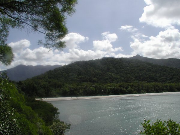


Geography and environment
The headland sits at the edge of a coastal rainforest biome and receives some of the highest rainfall in eastern Australia. The landscape is dominated by dense, tall forest, mangrove-fringed estuaries and fringing coral reef systems offshore. The coastal waters are close to the northern extent of the Great Barrier Reef, making the area notable for both terrestrial and marine biodiversity. The wet season brings heavy tropical rains and periodic track closures, while the dry months offer clearer access for visitors.
History and cultural connections
The Cape lies within the traditional lands of the Kuku Yalanji people, who have maintained a long-standing cultural and spiritual relationship with the country. European contact began in the late 18th and 19th centuries; the headland acquired its English name from the British navigator Lt. James Cook, who recorded that on 10 June 1770 his vessel ran onto a coral reef nearby, prompting the phrase "here began all our Troubles". Later settlers established small farms to supply inland mining communities.
Access, settlement and amenities
The sealed approach from the south crosses the Daintree River via a cable ferry and leads directly into the township. Northward access continues along the unsealed Bloomfield Track, a remote four-wheel-drive route connecting to the Bloomfield River, Wujal Wujal, Cooktown and other communities; this track is often impassable in the wet season. The village supports a handful of accommodation options, cafés and basic shops, including small supermarkets and ATMs, catering to visitors and locals alike.
Flora, fauna and safety
The Cape's rainforest hosts many plant and animal species characteristic of the Wet Tropics. Creek systems and estuaries are home to saltwater and freshwater populations of large reptiles, including crocodiles, so swimming is limited to safer, designated waterholes. Marine stingers are common in the warmer months, and seasonal precautions are advised. In 2006 the area recorded exceptional rainfall—over 5.7 metres—illustrating the intensity of the monsoonal wet season.
Tourism, activities and practical information
Cape Tribulation is a gateway for nature-based tourism that emphasizes low-impact exploration of rainforest and reef. Popular options for visitors include guided walks, boat-based wildlife cruises, and reef trips departing from the coastline. Local operators offer experiences such as:
- Horseriding along designated coastal tracks and beaches;
- Kayaking in calm estuaries and mangrove creeks;
- night walks and guided interpretation of flora and fauna;
- four-wheel-drive and cultural tours to nearby waterfalls and Indigenous communities.
Conservation and notable facts
Cape Tribulation sits at an ecological crossroads where the ancient Wet Tropics rainforest meets the living coral systems of the Great Barrier Reef. Its inclusion within protected areas helps conserve habitats and Indigenous cultural values, while tourism provides economic support for local communities. Visitors are encouraged to follow park guidelines, respect private and traditional lands, and observe seasonal closures and safety advice for marine and riverine environments.
Further information on regional facilities, safety alerts and cultural heritage can be obtained from local visitor centres and authorised operators before travelling to the area.
northern Queensland | Australia | distance | miles | Cairns | Wet Tropics | World Heritage | Cooktown | British | James Cook | 10 June 1770 | coral reef | rainforest | ATMs | crocodiles | Great Barrier Reef | horseriding | kayaking
Questions and answers
Q: What is Cape Tribulation?
A: Cape Tribulation is a headland and small town in northern Queensland, Australia 110 km north of Cairns. It is located in the Daintree National Park and the Wet Tropics World Heritage area.
Q: Who were the first people to live in the area?
A: The first people to live in the area were the Kuku Yalanji.
Q: How did Cape Tribulation get its name?
A: Cape Tribulation was named by British explorer Lt. James Cook on 10 June 1770 after his ship ran into a coral reef near the headland; "...because here began all our Troubles..."
Q: What is the weather like at Cape Tribulation?
A: Cape Tribulation is located in a rainforest and it gets a lot of rain, with an average rainfall of over 5.7 metres recorded in 2006. Most people visit during the dry season between July and November.
Q: Are there any activities available for visitors?
A: Yes, there are many activities available for visitors such as guided night walks, 4 wheel drive tours, horseriding, kayaking, jungle surfing, tropical fruit tasting and crocodile cruises. There are also two boats that take visitors to explore the Great Barrier Reef which is only 19 km due east from Cape Tribulation.
Related articles
Author
AlegsaOnline.com Cape Tribulation — headland and rainforest township in Queensland Leandro Alegsa
URL: https://en.alegsaonline.com/art/16726
Sources
- epa.qld.gov.au : Queensland Parks and Wildlife Service website - Cape tribulation - Daintree National Park.
- epa.qld.gov.au : Queensland Parks and Wildlife Service website - nature, culture and history
- capetribulation.com.au : capetribulation.com.au/
- daintreecoast.com : "History of the Daintree Coast"
- tfd.com : "Tribulation"
- gutenberg.org : Captain Cook's Journal During the First Voyage Round the World
- daintreecoast.com : "Cape Tribulation rainfall"
- commons.wikimedia.org : Cape Tribulation, Queensland