
Bering Sea: geography, ecology, history and human use
Overview of the Bering Sea: location, physical features, ecology, historical significance, fisheries and conservation issues affecting this marginal sea between Alaska and Siberia.
The Bering Sea is a large marginal sea of the North Pacific, lying between eastern Siberia and Alaska. It forms a broad marine region that links the Pacific Ocean to the Arctic via the narrow Bering Strait. The sea includes deep basins and extensive continental shelves, and its seasonal cycles of sea ice, currents and productivity make it one of the most biologically rich marine areas in the Northern Hemisphere. Coordinates often cited for the central region are shown here: 58°N, 178°W.
Image gallery
10 Images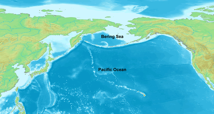




Physical characteristics
The Bering Sea is characterized by a contrast between a deep central basin and shallow continental shelves that extend from both the Asian and North American margins. The Aleutian Island chain forms its southern boundary and separates it from the open North Pacific, while the Alaska Peninsula shields parts of the eastern sea. Shelf areas are highly productive because of nutrient upwelling and seasonal mixing; the deeper basins accumulate cold water masses and play a role in large-scale circulation that connects to the Arctic.
Geography and political boundaries
Geographically the sea is bounded on the east and northeast by Alaska and on the west by Russia’s far eastern coast and the Kamchatka Peninsula. The Aleutian Islands and the Alaska Peninsula form the southern limits and the Bering Strait links northward to the Chukchi Sea and the Arctic Ocean. Portions of the Bering Sea fall within the exclusive economic zones of the United States and the Russian Federation, while central areas include waters beyond national jurisdiction. Important subregions include Bristol Bay on the eastern shelf and the shelf areas around the Pribilof Islands.
Ecology and natural resources
The Bering Sea supports abundant marine life, including large populations of fish (notably walleye pollock, salmon, cod and flatfish), shellfish (including commercially important crabs), seabirds and marine mammals such as seals, walrus and whales. Its shelf waters are among the most productive temperate to subarctic marine systems, supplying food and livelihoods for coastal communities. The region’s productivity depends on seasonal sea-ice dynamics, plankton blooms and nutrient flows driven by currents and wind patterns.
History and human use
Humans have used the Bering Sea and its coasts for thousands of years; Indigenous peoples of Alaska and Siberia depended on marine resources and seasonal migrations. During the last glacial period a land and ice bridge known as Beringia connected Asia and North America, facilitating human and animal movements. European exploration of the area accelerated in the 18th century—Vitus Bering led voyages that charted parts of the sea and lends his name to it. Today the sea remains vital for commercial fisheries, subsistence harvesting, shipping and international maritime activities.
Environmental concerns and management
The Bering Sea faces pressures from climate change (notably reduced sea-ice extent and warming waters), overfishing in some stocks, bycatch, pollution and increasing vessel traffic. These changes affect species distributions, timing of biological events and the resilience of coastal communities. Cooperative management between Alaska, Russian authorities and international bodies is necessary to conserve fish stocks, protect marine mammals and maintain sustainable coastal economies.
Further reading and resources
- Marginal seas: general information
- Pacific Ocean context
- Continental shelf and slope dynamics
- Gulf of Alaska relations
- Alaska Peninsula overview
- Alaska regional information
- Russia and the Far East
- Siberia geography
- Kamchatka Peninsula
- Aleutian Islands
- Bering Strait and Arctic gateway
- Arctic Ocean connections
- Chukchi Sea linkages
- Vitus Bering and exploration
- Danish navigators in Russian service
- International waters and jurisdiction
Questions and answers
Q: What are the coordinates of the Bering Sea?
A: The coordinates of the Bering Sea are 58°0′N 178°0′W / 58.000°N 178.000°W / 58.000; -178.000.
Q: What is the basin of the Bering Sea like?
A: The basin of the Bering Sea has deep water which then rises through a narrow slope into shallower water above the continental shelves.
Q: What separates the Bering Sea from the Gulf of Alaska?
A: The Alaska Peninsula separates the Bering Sea from the Gulf of Alaska.
Q: How large is it?
A: The Bering Sea covers over two million square kilometers in area.
Q: Who was Vitus Bering and why is it named after him?
A: Vitus Bering was a Danish navigator in Russian service who in 1728 was the first European to systematically explore it, and so it was named after him as a tribute to his exploration efforts.
Q: What countries does this sea border on?
A: The sea borders on Alaska, Russia's Siberia and Kamchatka Peninsula, and also onthe Alaska Peninsula and Aleutian Islands in its south, while its far north is bordered bytheBering Strait which connects it to Arctic Ocean's Chukchi Sea.
Q: Where does Bristol Bay fit into this picture?
A: Bristol Bay is part of the Bering Sea which separates mainland Alaska fromtheAlaska Peninsula
Related articles
Author
AlegsaOnline.com Bering Sea: geography, ecology, history and human use Leandro Alegsa
URL: https://en.alegsaonline.com/art/10713
Sources
- books.google.com : Ocean biogeochemistry: the role of the ocean carbon cycle in global change
- books.google.com : Encyclopedia of World Geography
- www1.american.edu : "North Pacific Overfishing (DONUT)"