
Aleutian Islands: geography, people, volcanism, and history
A concise overview of the Aleutian Islands: their geography, geology, ecology, human history, economy and significance as a volcanic, subarctic island chain linking the Bering Sea and North Pacific.
Overview
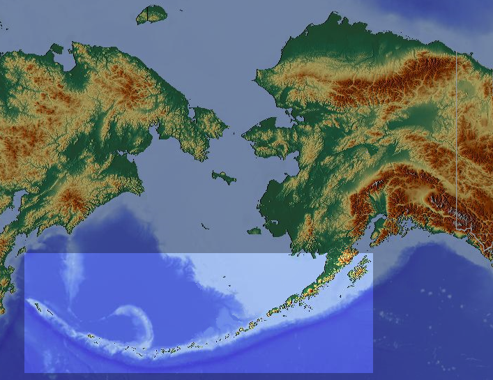
The Aleutian Islands form a long, narrow arc of more than 300 small islands stretching westward from the Alaska Peninsula toward the Kamchatka Peninsula. They extend roughly 1,200 miles and sit where the Bering Sea meets the North Pacific, creating a remote maritime landscape of rugged coasts, persistent fog, strong winds and cool temperatures. The chain lies across the 180th meridian, which contributes to its unusual status among U.S. territories as the most westerly part of the country in longitude and as a bridge between continents.
Image gallery
10 Images




Geography and geology
The islands are volcanic in origin and form part of a larger tectonic boundary. Subduction of the Pacific Plate beneath the North American Plate has produced dozens of active volcanoes and frequent earthquakes. This volcanic activity places the chain within the broader Ring of Fire. The landscape is characterized by steep, rocky shorelines, narrow beaches, and many bays and inlets; weather and sea conditions strongly shape the islands' ecology and human use. For general regional context see Northern Pacific and connections to the Bering Sea and the Gulf of Alaska.
Groups, settlements and administration
The chain is usually divided into several groups running east to west: the Fox Islands, the Islands of Four Mountains, the Andreanof Islands, the Rat Islands and the Near Islands. Most islands are part of the U.S. state of Alaska, while the far western extremity transitions to the Russian Commander Islands (Commander Islands). Human population is sparse: communities are small and often dependent on fishing, subsistence harvesting, and periodic ferry and air connections such as the Alaska Marine Highway.
People, culture and history
The islands are the ancestral home of the Unangax̂ (Aleut) people, whose maritime culture adapted to the sea, weather and seasonal resources. European contact began in the 18th century, bringing Russian fur traders and later American governance. During World War II the Aleutians were the site of notable military activity, including occupation and battles on some islands. More broadly, the chain has a layered history of indigenous life, colonial encounters and military significance that shaped population patterns and infrastructure.
Ecology, economy and uses
Ecologically the islands are important for seabird colonies, marine mammals and rich fisheries. Commercial fishing—targeting species like pollock, cod and salmon—and fish processing are primary economic activities for local residents. The islands also contain protected areas and are part of conservation efforts to safeguard breeding sites, migratory routes and unique subarctic habitats.
Notable facts and distinctions
- name origin: the English name "Aleutian" is linked to the Unangax̂ (Aleut) people and may be related to words from neighboring Arctic languages; see etymology.
- volcanism: the chain comprises numerous volcanic islands; many sources describe them simply as volcanic islands.
- location anchors: the arc begins near the Alaska Peninsula and stretches toward Kamchatka.
- political geography: the Aleutians mark a boundary between the continental U.S. and Asia and highlight maritime links to the westernmost U.S. by longitude.
- transport and access: remote communities rely on ferries, small aircraft and seasonal shipping for supplies and travel.
For more focused information about island groups, wildlife and travel logistics, consult regional resources and scientific summaries that specialize in northern Pacific islands and subarctic maritime environments (etymology, volcanism, geology, regional context, Alaska Peninsula, Kamchatka, Bering Sea, Gulf of Alaska, U.S. geography, Alaska administration, Commander Islands, transport routes).
Questions and answers
Q: What are the Aleutian Islands?
A: The Aleutian Islands are a chain of more than 300 small volcanic islands in the Northern Pacific Ocean.
Q: How big is the area covered by the Aleutian Islands?
A: The Aleutian Islands cover an area of 6,821 sq mi (17,666 km²).
Q: What is the distance between the Alaska Peninsula and the Kamchatka Peninsula?
A: The Aleutian Islands are spread out over an area of 6,821 sq mi (17,666 km²) and go out about 1,200 mi (1,931 km) west from the Alaska Peninsula toward the Kamchatka Peninsula.
Q: What is the significance of the Aleutian Islands?
A: The Aleutian Islands mark a line between the Bering Sea and the Pacific Gulf of Alaska. Crossing longitude 180°, they are the furthest West part of the United States.
Q: How many volcanoes are present on the Aleutian Islands?
A: The Aleutian Islands have 57 volcanoes.
Q: How many people live in the Aleutian Islands?
A: About 8,200 people live in 11 towns or villages on seven islands, in the US part of the Aleutian Islands. About 600 people live in the Russian part of the islands.
Q: What is the Pacific Ring of Fire?
A: The Pacific Ring of Fire is an area in the Pacific Basin where a large number of earthquakes and volcanic eruptions occur. The Aleutian Islands are in the northern part of the Pacific Ring of Fire.
Related articles
Author
AlegsaOnline.com Aleutian Islands: geography, people, volcanism, and history Leandro Alegsa
URL: https://en.alegsaonline.com/art/2311