Alaska
![]()
The title of this article is ambiguous. For other meanings, see Alaska (disambiguation).
Alaska (English pronunciation [![]()
![]() əˈlæskə], from Aleut Alax̂sxax̂, pronunciation [a'laχshaχ], "land in whose direction the sea flows" via Russian Аляска [
əˈlæskə], from Aleut Alax̂sxax̂, pronunciation [a'laχshaχ], "land in whose direction the sea flows" via Russian Аляска [![]()
![]() ɐˈlʲæskə]) is, with 1,717,854 km², of which 1,481.346 km² is land, it is the largest in area (nearly 17.5% of the total), the northernmost, westernmost, and-if east and west are considered to be firmly defined hemispheres of the Earth between the prime meridian and antimeridian-also the easternmost state (the Aleutian Islands extend almost to eastern Siberia) in the United States of America, and the largest exclave on Earth. Alaska has the fourth lowest population of any state (only 0.22% of the total U.S. population). The U.S. acquired the territory from the Russian Empire in 1867; it became the 49th state of the U.S. on January 3, 1959. Alaska has the nickname Last Frontier. The Alaska Permanent Fund is a special fiscal feature.
ɐˈlʲæskə]) is, with 1,717,854 km², of which 1,481.346 km² is land, it is the largest in area (nearly 17.5% of the total), the northernmost, westernmost, and-if east and west are considered to be firmly defined hemispheres of the Earth between the prime meridian and antimeridian-also the easternmost state (the Aleutian Islands extend almost to eastern Siberia) in the United States of America, and the largest exclave on Earth. Alaska has the fourth lowest population of any state (only 0.22% of the total U.S. population). The U.S. acquired the territory from the Russian Empire in 1867; it became the 49th state of the U.S. on January 3, 1959. Alaska has the nickname Last Frontier. The Alaska Permanent Fund is a special fiscal feature.

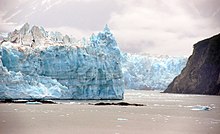
Hubbard Glacier
Geography
Alaska consists of three major landscape areas: the mountain range along the entire southern Pacific coast, the Yukon lowlands with their mountain and hill country, and the coastal plain ("North Slope") on the Arctic Ocean.
The largest river or stream in the country is the Yukon River, which rises in the Canadian Rocky Mountains, flows west, cuts through the middle of Alaska and flows into the Bering Sea. To the east, Alaska borders the Canadian territory of Yukon.
There are thousands of lakes in the territory of Alaska, the largest of which (Becharof, Iliamna, Naknek and Ugashik) are located on the Alaska Peninsula or at the junction of the mainland with this peninsula.
In the southwest of Alaska lies the narrow Alaska Peninsula, which is joined by the Aleutian Islands; both on the peninsula and on the elongated island chain is the Aleutian Chain, which rises to 3109 m in Mount Redoubt. In the north-central part of the state are the mountains of the Alaska Range, which includes Denali (Mount McKinley) - at 6190 m the highest mountain in this range and in all of North America. In the arctic north, the Brooks range rises to 2749 m high. In the southwest, the Wrangell Mountains in Mount Blackburn rise to 4996 m, the Waxell-Barkley Ridge to 3261 m and the Elias Range bordering Canada with Mount Saint Elias in Alaska to 5489 m high. In the extreme southeast lies the Alaska Panhandle, a narrow strip along the Pacific Ocean, west of the Canadian province of British Columbia, most of whose towns can only be reached by boat or plane. The capital, Juneau, is also located there. The rest of Alaska is characterized by densely forested hill country and countless coastal fjords.
The mountain system along the Pacific coast is geologically unstable, plate tectonic processes around the Pacific Plate make the southeastern coast and the Aleutian Islands part of the Pacific Ring of Fire. It is volcanically active, triggering earthquakes and seaquakes. The southern side is heavily glaciated: Malaspina, in southeastern Alaska near the coast on the Gulf of Alaska, is the largest nonpolar mountain glacier on Earth, covering 4275 km². At its thickest point, the glacier, which is about 100 km long and up to 65 km wide, is more than 600 m thick. The central part of the state includes the lowlands of the Yukon and Kuskokwim Rivers. The coastal plain in the north slopes gradually down from the Brooks Range to the Arctic Ocean.
The Rat Islands and Near Islands, which belong to the Aleutian Islands, are the only areas of the USA whose longitude is given in easterly direction, they lie between 170° and 180° east.
AlaskanBush refers to all parts of the state that are not connected to the North American road system or accessible by the Alaska Marine Highway.
Alaska is bordered by the Canadian territory of Yukon to the east, the Bering Sea to the west, the Arctic Ocean to the north, and the Gulf of Alaska, which is part of the Pacific Ocean, to the south.
Management structure
Alaska is not divided into counties (Landkreise) like the other states, but into 19 Boroughs, which are similar to the counties in the other states, the Landkreise in Germany and the Bezirke in Austria, as well as the so-called Unorganized Borough. This Borough, in turn, is divided into Census Areas with no public administration. Their boundaries, in turn, were not established by the State of Alaska, but by the U.S. Census Bureau. In 1961, the entire state of Alaska was assigned to the Unorganized Borough. Only gradually, in the desire for local self-government, did the boroughs that exist today emerge.
See also: List of Boroughs and Census Areas in Alaska
Climate
Alaska has a continental climate in the interior, a subpolar climate in the west and a polar tundra climate in the north. Winters here are long, dark and very cold. In the short summer, however, it can become quite warm, on the north coast the temperatures then rise above 0 °C. Even on the tops of the mountains it is very cold. Even on the summits of the mountains north of the Rocky Mountains (up to 3000 m) most of the snow melts in summer. Except for the summer months, there is little precipitation (100-300 mm), mostly in the form of snow. On the south and west coasts it is more temperate and rainier. Here, even in winter, temperatures rarely fall below -10 °C, and summers are only moderately warm. But it is very humid, there are sometimes 300 rainy days per year. In the south of Alaska, the glaciers partly reach the sea.
Alaska's previous heat record was 37.8 °C at Fort Yukon on June 27, 1915, and the lowest temperature was -62 °C at Prospect Creek on January 23, 1971.
· 
Annual mean temperatures 1833-2013 in Alaska
· -USA.png)
Climate diagram of Anchorage
· 
Climate diagram of Cold Bay
· -USA.png)
Climate chart of Fairbanks
· -USA.png)
Juneau climate chart
· -USA.png)
Kodiak Island Climate Chart
· -USA.png)
Nome climate chart
Alaska is one of the regions of the world where global warming is having a strong impact. According to analyses by Berkeley Earth, the average temperature in Alaska rose by about 2 °C between 1970 and 2005. As a result of climate change, the number of fires in boreal forest areas has increased, reaching levels not seen in the past 10,000 years, according to one study. For example, several wildfires were recorded in Alaska in 2019.

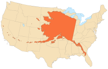
Size comparison between Alaska and the "Lower 48" (true to scale projection, not true to scale regarding the shape)
Population
| Population development | |||
| Census | Inhabitants | ± in % | |
| 1880 | 33.426 | - — | |
| 1890 | 32.052 | −4,1 % | |
| 1900 | 63.592 | 98,4 % | |
| 1910 | 64.356 | 1,2 % | |
| 1920 | 55.036 | −14,5 % | |
| 1930 | 59.278 | 7,7 % | |
| 1940 | 72.524 | 22,3 % | |
| 1950 | 128.643 | 77,4 % | |
| 1960 | 226.167 | 75,8 % | |
| 1970 | 300.382 | 32,8 % | |
| 1980 | 401.851 | 33,8 % | |
| 1990 | 550.043 | 36,9 % | |
| 2000 | 626.932 | 14 % | |
| 2010 | 710.231 | 13,3 % | |
| Before 1900 1900–1990 2000 | |||
Alaska has a population of 738,432 (as of 2015), of which 66.7% are white, 14.8% are indigenous (American Indian, Eskimo, and Aleut, highest percentage in the U.S.), 5.5% are Hispanic or Latino, 5.4% are Asian American, 3.3% are African American, and 0.6% are Hawaiian or Pacific Islander. There are 258,058 households.
Age and gender structure
Alaska's age structure is made up as follows:
- up to 18 years: 132,440 (18.7 %)
- 18-64 years: 522,853 (73.6 %)
- 65 years and older: 54,938 (7.7 %)
The median age is 33.8 years. 52.0% of the population is male and 48.0% is female.
Ethnic composition of the population
15.1% of the inhabitants are of German descent, which is about 49,000 and thus represents the largest group. This is followed by the groups of Irish (10.6%), English (8.2%) and Norwegian (3.6%) descent.(As of 2014) Despite the region's long Russian past, the proportion of people of Russian descent is relatively low, at 1.1%. Their heritage is reflected today mainly in numerous toponyms and field names. An exception is the village (CDP) of Nikolaevsk on the Kenai Peninsula, where in 2000 two-thirds of the population still spoke Russian in everyday life.
Religions
The religious denominations with the most members in 2000 were the Catholic Church with 54,359 and the Southern Baptist Convention with 22,959 adherents. They were followed by the Orthodox Church with about 20,000 members and the Church of Jesus Christ of Latter-day Saints with 19,019 members. In statistical surveys, 33% of U.S. citizens living in Alaska reported belonging to a denomination. The various evangelical churches together have about 78,000 adherents.
The comparatively high number of Orthodox Christians can be traced back to the missionization of the native Indians during the Russian colonial period. Most Orthodox Christians in Alaska have Native American ancestors.
Largest cities
Besides the capital Juneau, Anchorage, by far the largest city in the state, and Fairbanks are the most important cities in Alaska.

See also: List of cities in Alaska

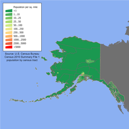
Inhabitants per square mile
Questions and Answers
Q: What is the official name of Alaska?
A: The official name of Alaska is the State of Alaska.
Q: How many people live in Alaska as of 2011?
A: As of the 2011 census, 722,718 people live in Alaska.
Q: What are some important exports from Alaska?
A: Some important exports from Alaska include seafood such as salmon, cod, Pollock and crab, as well as oil and gas.
Q: When did the United States buy Alaska from Russia?
A: The United States bought Alaska from Russia on March 30, 1867. This was called the Alaska Purchase.
Q: How much did it cost to purchase Alaska?
A: It cost $7.2 million at the time; today that would be $120 million. The price was about $0.02 per acre ($4.74/km2).
Q: When did Alask become an organized territory?
A: Alask became an organized (or incorporated) territory on May 11, 1912.
Q: What does "Alaska" mean in Aleut language?
A:"Alaska" means "the mainland" or "the object towards which the action of the sea is directed" in Aleut language
Search within the encyclopedia