Prime Meridian: The zero‑degree line of longitude and its role in navigation
The Prime Meridian is the imaginary zero‑degree longitude line that passes through Greenwich; it defines east/west coordinates and historically set the basis for GMT and global timekeeping.
The Prime Meridian is the reference meridian defined as zero degrees longitude. It is an imaginary north–south line used to specify the east–west position of places on Earth. The most familiar modern marker for this reference runs through the Royal Observatory, Greenwich, in London, and the term Greenwich Meridian is commonly used to describe it. By convention, longitudes are expressed as degrees east or west of this zero line, enabling a single, consistent system of geographic coordinates (longitude).
Image gallery
7 Images


How the meridian relates to latitude, longitude and coordinates
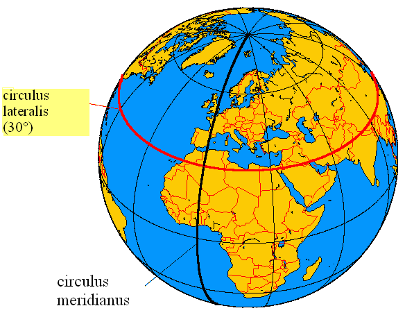
Lines that circle the globe east–west are latitudes and indicate distance north or south of the equator. In contrast, the Prime Meridian is one of the family of meridians or lines of longitude that run roughly north–south from pole to pole. These meridians are not physical tracks on the ground but mathematical references used by maps, charts and positioning systems. The direction of these lines may be described as vertical in common explanations, sometimes noted as the vertical component of a coordinate grid, while latitudes are described as horizontal (east–west).
Historical development and standardization
For centuries, different countries and observatories used local prime meridians for navigation and mapmaking. In 1884 an international conference chose the Greenwich Meridian as the global standard, making it the reference for maps and time. That decision led to the adoption of Greenwich Mean Time (GMT) as the basis for civil timekeeping; later, atomic time and Coordinated Universal Time (UTC) superseded GMT for precision, but the Prime Meridian remained the zero‑longitude reference. Advances in satellite geodesy and a global reference frame used by GPS now define a geodetic meridian that is slightly offset from the historical Greenwich line; modern measurement systems use highly accurate satellite and clock data rather than local astronomical observations.
Geographic route from pole to pole
Viewed on a world map, the Prime Meridian crosses both land and ocean. From the North Pole southward it passes through:
- England — the location of the Royal Observatory in Greenwich
- France
- Spain
- Algeria
- Mali
- Burkina Faso
- Antarctica — and it crosses several coastal and maritime zones on the way
Some lists include additional territories or slightly different routing depending on map projection and the exact reference meridian chosen for a particular datum.
Uses, significance and cultural impact
The Prime Meridian underpins navigation, mapping, global time zones and surveying. Cartographers and GPS systems rely on zero‑longitude to convert spherical positions into usable coordinates; pilots, mariners and surveyors use those coordinates routinely. As a cultural and tourist symbol, the Greenwich site attracts visitors who stand with one foot in the eastern hemisphere and one in the western. Markers, plaques and meridian monuments exist in many places as reminders of the practical need to standardize geographic reference.
Notable distinctions and facts
Important distinctions include the difference between the historical astronomical Greenwich meridian and the modern geodetic prime meridian used by satellite systems; the latter is determined by a global reference frame established with very precise observations. The name International Meridian is sometimes used in historical contexts to describe the adopted standard. Although invisible on the landscape, the Prime Meridian continues to function as a foundational element of global geography, timekeeping and navigation.
Related articles
Author
AlegsaOnline.com Prime Meridian: The zero‑degree line of longitude and its role in navigation Leandro Alegsa
URL: https://en.alegsaonline.com/art/79036