Algeria
![]()
This article is about the state in Africa. For other meanings, see Algeria.
Template:Infobox State/Maintenance/TRANSCRIPTION
Template:Infobox State/Maintenance/NAME-German
Algeria (Arabic الجزائر al-Jazā'ir, DMG al-Ǧazāʾir 'the islands'; Berber ⵍⴻⵣⵣⴰⵢⴻⵔ Lezzayer, ⵍⴷⵣⴰⵢⴻⵔ Ldzayer and ⴷⵣⴰⵢⴻⵔ Dzayer; officially al-Jumhūrīya al-Jazā'irīya ad-Dīmūqrātīya asch-Shaʿbīya / الجمهورية الجَزائرية الديمقراطية الشعبية / 'People's Democratic Republic of Algeria', in Berber ⵜⴰⴳⴷⵓⴷⴰ ⵜⴰⵣⵣⴰⵢⵔⵉⵜ ⵜⴰⵎⴰⴳⴷⴰⵢⵜ ⵜⴰⵖⴻⵔⴼⴰⵏⵜ Tagduda tazzayrit tamagdayt taɣerfant) is a state in northwestern Africa.
Algeria, as the middle of the Maghreb countries, is the largest state on the African continent in terms of area and the tenth largest state in the world. By population, Algeria ranked eighth within Africa in 2017, with just over 41 million. It is bordered by the Mediterranean Sea to the north, Mauritania, Morocco and the Western Sahara claimed by Morocco to the west, Mali and Niger to the south, and Libya and Tunisia to the east. The country is named after its capital, Algiers (Alger in French). Other major cities include Oran, Constantine, Annaba, and Batna. The country became independent after the end of the Algerian War (1954-1962). With the constitution of 1996, a semi-presidential system of government came into force.
Geography
The northern part of Algeria, on the southern coast of the Mediterranean Sea and in the Atlas Mountains, is home to the majority of the population. The much larger southern part, called Le Grand Sud in Algeria, is sparsely populated and dominated by the desert regions of the Sahara.
Behind the only narrow, bay-rich fringe of the Mediterranean coast rises the steeply rising Tellatlas. The mountain range, divided by basins, longitudinal and transverse valleys, reaches a height of 2308 m east of Algiers in the wildly ravaged Kabylia, and southwest of Algiers the Ouarsenis Mountains rise to 1963 m. The southern side of the Tellatlas slopes to the highlands of the Scotts at 1000 m to 391 m. Here lie numerous drainless, marshy salt lakes, the so-called Schotts. South of this up to 150 km wide highland is the Sahara Atlas; it runs parallel to the coast and the Tell Atlas. Its highest mountain is 2328 m high.
Beyond the striking southern slope of the Atlas Mountains, which drops to 35 m below sea level at the Melghir bulkhead in the eastern lowlands, the Algerian Sahara spreads out; at a good two million square kilometres, it covers 85 % of the country's surface. A strip of desert steppe in the north is followed by the extensive, almost vegetationless sand dune areas of the Eastern Great Erg, the Western Great Erg, the Erg Iguidi and the Erg Chech. To a greater extent, the Sahara of Algeria is occupied by stony plateaus such as the Hammada du Draa or the Hammada du Guir in the west and by stepped landscapes (Tassili n'Ajjer in the southeast). To the south rises the Ahaggar massif, 2908 m high in the Tahat (the highest mountain in Algeria), a desert-like high mountain range of volcanic origin that is still prone to earthquakes today. South of the Tassili n'Ajjer lie the large dune areas of the Chad Basin.
As the longest among the otherwise mostly short permanent rivers in the coastal region of the Tell Atlas, the Cheliff is to be mentioned. Further south, Algeria's river valleys are mostly dry (wadis) and sometimes lined with oases; heavy rains - even in more remote areas - can suddenly turn a wadi into a torrent. One of the longest of these dry valleys has been created by the Wadi Igharghar.
Climate
Algeria has a Mediterranean climate in the north and an extremely dry desert climate in the south. On the Mediterranean coast and the northern slopes of the Tell Atlas, the mean temperature in August is 25 °C, in January 12 °C; precipitation (500 to 1000 mm on average) falls mainly in winter. The highlands of the Scotts are dominated by a winter-humid steppe climate with pronounced seasonal temperature fluctuations (January mean barely above 0 °C, August mean 30 °C). Precipitation, mostly in the form of short downpours, amounts to only 350 mm here. The northern slope of the Sahara Atlas receives more rainfall; on the southern side, however, there is a rapid transition to the hot, dry desert climate of the Sahara with daily temperature fluctuations of up to 20 °C and more. Temperatures reach over 40 °C in summer and can drop below 0 °C in winter. In some areas, the long-term average precipitation is only 10 mm. The scirocco, a dry, dust-laden wind, often blows from the Sahara in the summer months.
flora and fauna
Today, Algeria has a forest cover of only 2 %, and about 80 % of the country is almost devoid of vegetation. Targeted reforestation measures such as the Barrage vert aim to slow down the spread of the desert. Between 1990 and 2000, the forest cover increased by 1.3 %. Mediterranean shrubs such as maquis, Aleppo pines, cork oaks and holm oaks as well as (above 1600 m) Atlas cedars grow on the sufficiently irrigated northern side of the Tell Atlas; in Kabylia there are still contiguous forest areas.
The highlands of the Scotts are dominated by steppes with half-grass and wormwood plants. The mountain steppe of the Sahara Atlas merges southward into the largely vegetationless desert; plants (especially date palms) grow only in marginal zones and areas favored by groundwater (oases). The Ahaggar Mountains are forestless; in places there is Mediterranean vegetation.
Wild animals include gazelles, desert foxes (fennecs), maned sheep, Barbary macaques, occasional cheetahs, jumping mice, snakes, lizards, scorpions and various bird species (including large birds of prey). Originally, Barbary lions and Atlas bears were also native to Algeria. However, the wild populations are extinct.
In the Tassilin'Ajjer National Park, a UNESCO World Natural and Cultural Heritage Site, there are still populations of maned sheep and dune gazelles, as well as a few cheetahs.
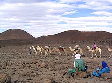
The Ahaggar Mountains in Southern Algeria
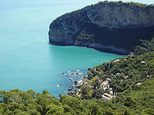
Bejaia, coastal town of Kabylia
Population
Algeria's population has grown from 6.1 million in 1926 to 42.2 million in 2018. As a result of strong population growth, the proportion of people under 15 years of age was 25.4% in 2010. The birth rate was 2.7 children per woman in 2016.
Almost all Algerians are of Berber origin; only about 40% profess their Berber identity. Algeria underwent extensive Arabization in terms of culture, language and religion in the course of Islamization in the 7th and 8th centuries. Algeria is populated mainly by people who call themselves Arabs (70%) and various Berber tribes (30%), some of whom are Arabized. As the ethnic groups have increasingly intermingled since the 20th century, it is sometimes difficult to assign an Algerian to a particular tribe. Increasing numbers have both Arab and Berber roots. The number of Europeans, who still made up 10% of the population under French rule in 1960, dropped to about 20,000 after independence. After centuries of Ottoman rule, the number of the Ottoman-born population called Kulughli (with Turkish, Kurdish and partly Armenian roots) is estimated at 600,000 to 2 million.
The population in Algeria is very unevenly distributed. 96 % of the inhabitants live in the north on one fifth of the national territory. More than half (65 % in 2008) - with an upward trend - already live in the cities, which are mainly located in the coastal area. An estimated 2.3 million Algerians live abroad, over 1.5 million of them in France, where they are the main representatives of Islam in France. The causes of the high emigration rate are mainly the growing population pressure and lack of job opportunities. In Algeria, only 0.6% of the population were foreigners in 2017. The country thus has a very low migrant population.
Languages
The official languages of Algeria are Arabic and various Tamazight. French plays an important role as a language of education, trade and communication. Algeria is considered the country with the most French speakers outside France; however, for political reasons it does not profess Francophonie. State television channels also broadcast news and documentaries in French; on state radio, one of the three main programs is in French. Tamazight has also had the status of a national language since 2002, and since 2016 it has been an official language in which radio programmes and occasional television programmes are also broadcast.
The main written languages used are French and High Arabic; since the 1970s, government initiatives have promoted the use of High Arabic and pushed back the use of French. Kabyle is widely used as a written language, especially in Greater and Lesser Kabylia, but almost only young people are able to speak it, since those over 30 have not yet been literated in Kabyle at school.
Today (as of 2014), the mother tongue of about 70% of the population is an Algerian dialect of Arabic (Darja), which differs significantly from High Arabic, which is predominant in the media, politics, administration and schools. The mother tongue of another 30% or so of the population is Tamazight. The south of the country is almost exclusively inhabited by Tamazheq-speaking Tuareg (who belong to the Amazigh).
French is understood by almost all Algerians; however, the degree of proficiency varies greatly. Older people whose schooling took place before the conversion of the school system from French to High Arabic (1976), academically educated people and many inhabitants of Kabylia usually speak French fluently with near-native competence. Younger people, on the other hand, often have a faulty command of French in written form and use a français régional, a mixed language of French and Darja.
A small minority in western Algeria speaks Korandje, the northernmost of the Songhai languages.
Religions
Between 98% and 99% of the population profess Islam. A minority, mainly foreigners living in Algeria and converted Algerians, belong to Christianity in Algeria, traditionally the Algerian Catholic Church. In the wake of the civil war that broke out in 1992 between the government and the Islamist Salvation Front (FIS), which did not shy away from mass murders of compatriots, some Algerians, especially in Kabylia, turned to Protestant Christianity. Some of the Protestant communities in Kabylia have existed since the 1930s. In addition, there is still a small number of inhabitants of Jewish faith (today less than 0.1% of the population). The Mozabites are an Islamic minority.
Algeria has declared Sunni Islam as the state religion. In the second half of the 20th century, Islam gained more and more influence in the daily life of Algerians. Algeria's independence movement was already strongly imbued with Islam, which is why religious leaders demanded more rights after the victory over France. Since 1963, citizenship laws have been based on Islam; since 1964, the Koran has been taught in all schools. Over time, Sharia law was also introduced as the basis of the legal system: Since 1984, a family law has been in force in which the discrimination or different treatment of women is stipulated. A law that came into force on 28 March 2006 makes the proselytising of Muslims by other religions punishable by severe penalties.
Social
There is general social insurance for all employees; an old-age pension is paid from the age of 60. There are also disability and survivors' pensions. What is missing is an unemployment benefit - a shortcoming that has considerable social implications given the high unemployment rate (2016: 12.4%).
Education
Compulsory education is compulsory for 6 to 15 year olds. This can be followed by three years at a secondary school. The languages of instruction are French and Arabic. The differences in education and training between men and women and between urban and rural areas are still considerable. In Algeria, median school attendance increased from 3.6 years in 1990 to 7.8 years in 2015. Adult literacy programs and higher enrollment rates have slowly lowered illiteracy rates in recent decades to now 13% for males and 27% for females. The country has twelve universities; the oldest was founded in Algiers in 1879.
The reform of the Algerian school system with the aim of fundamentally modernising school teaching has been driven forward by the government since 2014. European foreign languages are given an important role - after the years of Arabisation of the school system. French is first, English second, German, Spanish or Italian third foreign language. In practice, the reform suffers from a lack of specialists (emigration of teachers abroad, stagnating student numbers/about 1.3 million in the 2014/15 academic year), the lack of modern foreign language didactics and frequent strikes by teaching staff. Only a portion of Algerian teachers were trained at universities. In the 2015 PISA ranking, Algerian students ranked 71st in mathematics, 71st in science, and 69th in reading comprehension; the situation in a total of 72 states was examined in the study.
Health
Despite improvements, the standard of health care is still inadequate. Despite general free medical care for the population, a considerable urban-rural divide can be observed above all. Life expectancy in 2016 was 76.8 years; here there has been a considerable increase since the end of the colonial era. In 2006, per capita government health expenditure was US$146 (purchasing power parity). The HIV infection rate is low.
| Development of life expectancy | |||
| Period | Life expectancy in years | Period | Life expectancy in years |
| 1950–1955 | 42,9 | 1985–1990 | 65,9 |
| 1955–1960 | 45,0 | 1990–1995 | 67,2 |
| 1960–1965 | 47,3 | 1995–2000 | 69,1 |
| 1965–1970 | 49,5 | 2000–2005 | 71,5 |
| 1970–1975 | 51,5 | 2005–2010 | 73,9 |
| 1975–1980 | 54,9 | 2010–2015 | 75,3 |
| 1980–1985 | 61,6 | ||
Source: UN
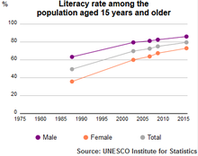
UIS reading ability of the population of Algeria 1985-2015
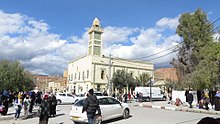
Al-Atik Mosque
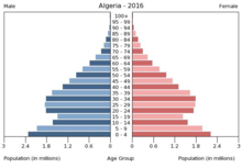
Population pyramid Algeria 2016.
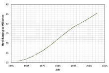
Population development in millions
Questions and Answers
Q: What is the official name of Algeria?
A: The official name of Algeria is the People's Democratic Republic of Algeria.
Q: Where is Algeria located?
A: Algeria is located in North Africa and it is part of the Maghreb region of Northwest Africa.
Q: What city is the capital of Algeria?
A: Algiers is the capital city of Algeria.
Q: What countries border Algeria?
A: Algeria borders Tunisia in the northeast, Libya in the east, Niger in the southeast, Mauritania and Mali in the southwest, Western Sahara in the west and Morocco in the northwest.
Q: Is it a large country?
A: Yes, it is actually one of largest countries both on African continent and Arab world.
Q: Does it have access to a sea?
A: Yes, it has access to Mediterranean Sea which lies to its north.
Q:What region does it belong to ? A:It belongs to Maghreb region of Northwest Africa
Search within the encyclopedia