Antarctica: geography, climate, ecosystems, history and scientific significance
Antarctica — Earth's southernmost continent — is dominated by ice, extreme climate, unique ecosystems, and international scientific cooperation under treaty protections.
Overview
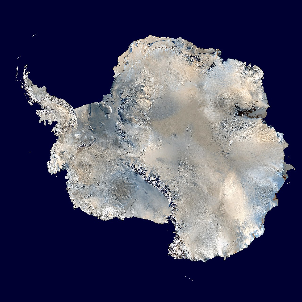
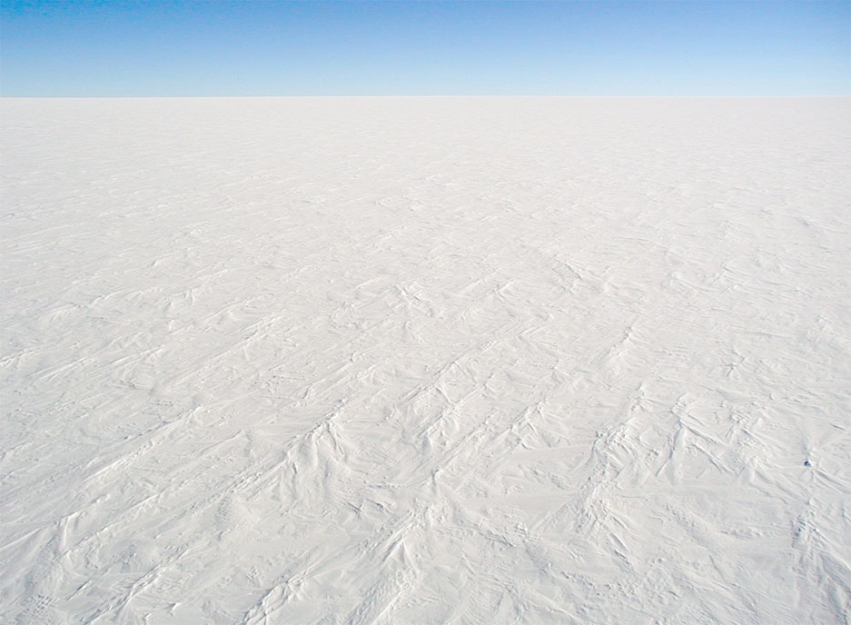
Antarctica lies at the very southern extreme of the planet and is commonly described as Earth's southernmost landmass. It is recognized as a distinct continent centered on the South Pole, with most of its area south of the Antarctic Circle. The continent is surrounded by the Southern Ocean and is the fifth-largest continent by area after Asia, Africa, North America and South America. About 99% of Antarctica is covered by ice, with the ice sheet averaging well over a thousand metres in thickness.
Image gallery
9 Images


Geography and climate
The ice cover makes Antarctica, on average, the highest of the continents and gives it the coldest mean temperatures on Earth. Strong katabatic and coastal winds contribute to its reputation as one of the windiest regions. Low atmospheric moisture makes large parts of the interior functionally a desert, with very low precipitation in the interior and somewhat higher snowfall nearer the coast. Coastal and island climates are influenced by the surrounding ocean and can be milder in summer.
Ice sheets and sea level
The Antarctic ice sheets store the majority of the Earth's freshwater in frozen form. Their size and behavior are central to global sea-level projections because melting or changes in ice flow can raise sea levels worldwide. Glaciologists study the dynamics of grounded ice, floating ice shelves, and outlet glaciers to improve understanding of how the ice mass responds to atmospheric and ocean changes.
Life and ecosystems
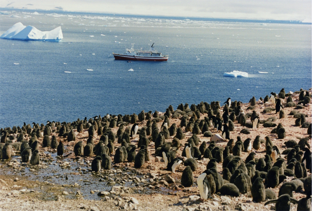
Terrestrial life is limited and concentrated in ice-free areas and along the coasts. Small plants such as patches of grass and shrubs exist in rare, exposed places, while algae, lichen and microbial mats perform much of the primary production. Microscopic and invertebrate fauna such as nematodes and resilient tardigrades survive in soils and cryoconite, and diverse bacteria play key roles in local nutrient cycles. Coastal and marine ecosystems are richer: iconic penguins, a variety of seals, seabirds, fish and invertebrates depend on the productive waters of the Southern Ocean.
Human presence, research and logistics
There is no permanent indigenous human population in Antarctica. Instead research personnel occupy a network of seasonal and year-round facilities. Around one thousand to several thousand people are present at different times, and scientific work ranges across glaciology, atmospheric science, marine biology and astronomy. Many research programs operate through international cooperation and share logistical resources; the network of science stations is a visible expression of that collaboration.
History of exploration and naming
Coastal sightings and incursions into southern waters date to the early nineteenth century, and the continent remained little visited for decades because of its isolation and harsh climate, often described as a hostile environment. The modern use of the name Antarctica was popularized through later nineteenth-century cartography, where figures such as John George Bartholomew and map-making firms including Bartholomew helped standardize geographic names and representations.
Governance and the Antarctic Treaty
Antarctica is governed internationally under agreements that began with the Antarctic Treaty of 1959. The treaty and related measures limit military activity and set strong constraints on commercial exploitation of resources, in particular controls intended to prevent large-scale mineral mining activities. The treaty system promotes scientific cooperation and seeks to protect the polar ecozone and its biodiversity through environmental protocols and inspection mechanisms.
Contemporary issues and conservation
Contemporary concerns include the response of ice sheets to global warming, the conservation of marine and coastal species, sustainable management of tourism, and coordination of international science. Monitoring programs, protected areas and rules for visitor conduct aim to reduce human impact while permitting valuable research. The international character of the Antarctic governance regime means that many nations and scientific bodies work together to address these shared global challenges.
- Key wildlife examples: penguins, seals, seabirds
- Microbial and plant life: algae, lichen, bacteria
- Exploration and mapping: early sightings, mapping by John George Bartholomew and firms such as Bartholomew
- Policy and protection: Antarctic Treaty, limits on military use and mining of minerals
- Research infrastructure: international science stations and shared logistics
Name
Antarctica has the same linguistic root as Antarctica: Greek ἀνταρκτικός antarktikos, "facing the Arctic". "Arctic" in turn derives from the ancient Greek word Άρκτος arktós for "bear", which goes back to the constellation of the Great Bear. There is no comparable polar land mass in the Arctic.
In German usage, however, especially after 1920, the name Antarktika became uncommon, unlike in other languages. Instead, it became established to use "the Antarctic" to refer to both the entire southern polar region and the continent lying within it.
From the double meaning of the word Antarctica follows a lack of distinction between region and continent. This was criticized, among others, by the German polar researcher and marine biologist Leonid Breitfuß in 1946 in the journal Polarforschung. He demanded that the terms be distinguished as is customary in other languages and that Antarctica continue to be used for the region, but that the name Antarctica be used for the continent.
Geography
Antarctica lies entirely south of 60 degrees south latitude and is surrounded by the Southern Ocean. In addition to the Antarctic mainland, the continent includes numerous offshore islands on the continental shelf as well as the numerous shelf ice shelves.
The northernmost point of the Antarctic mainland is Prime Head 23 km northwest of Hope Bay in the north of the Antarctic Peninsula, at 61° 0′ 3.6″ S. The northernmost point of the Antarctic continent is on one of the tiny Seal Islands (at 60° 56′ 5″ S), one of the numerous offshore sub-Antarctic islands, about eight kilometres north of Cape Yelcho, the northern point of Elephant Island, one of the South Shetland Islands. The Southern Orkney Islands, on the other hand, which lie even further north, are no longer commonly included in the continent of Antarctica, although they too still lie entirely south of 60° S latitude.
The southernmost point of the continent is the geographic South Pole in East Antarctica.
The nearest major landmasses are Tierra del Fuego at the southern tip of South America, then Cape Agulhas in South Africa, and the islands of Tasmania and New Zealand.
West and East Antarctica
→ Main article: West Antarctica and East Antarctica
The continent of Antarctica is divided into the subcontinents of West Antarctica, which lies mostly west of the Greenwich meridian and east of 180 degrees longitude, and East Antarctica, which lies east of the Greenwich meridian and west of 180 degrees longitude. The two major landscapes are geographically divided by the Transantarctic Mountains.
West Antarctica
West Antarctica has a rugged surface divided into several peninsulas, mainly covered with an ice sheet. The climate is more oceanic, which is why the temperatures are not as extremely low as in East Antarctica.
- Antarctic Peninsula
- Grahamland
- Palmerland
- Edward VII Peninsula
- Ellsworthland
- Marie Byrd Land
East Antarctica
The surface of East Antarctica consists of a single, huge ice sheet. The climate is continental and only slightly influenced by the sea, which leads to extreme temperatures of up to -89.4 °C (measured on 21 July 1983).
- Adélieland
- American Highlands
- Antarctic Dry Valleys
- Coatsland
- Enderbyland
- Gamburzew Mountains
- Kaiser-Wilhelm-II-land with Gaussberg
- Queen Maud Land
- Neuschwabenland
- Polar Plateau
- Princess Elizabeth Land
- Prince Charles Mountains
- Victoriana
- Wilkesland
In addition to the South Pole, East Antarctica is also home to the middle of the continent, known as the "South Pole of Inaccessibility".
Islands
Some of the islands of Antarctica are surrounded by sea all around, others are connected to the continent via the ice shelf, so that their island character is only recognizable under the ice. Some of the islands are of volcanic origin.
Some islands off the coast of Antarctica and in the Southern Ocean:
- Alexander I Island (the largest island in Antarctica)
- Berkner Island (second largest island in Antarctica, completely enclosed by the Filchner-Ronne Ice Shelf)
- Joinville Islands
- Roosevelt Island (largest island in the Ross Ice Shelf)
- Ross Island (southernmost island that can be reached from the sea)
- South Shetland Islands
- Thurston Island (third largest island in Antarctica)
See also: List of Antarctic and Subantarctic Islands
Mountain
The mountains of Antarctica, especially in the interior, are partly completely buried under the ice sheet (subglacial mountains, up to 3500 m high). However, there are also mountains and ranges that are not or only partially covered by the ice sheet.
The highest mountain in Antarctica is Mount Vinson (4892 m), located in the Sentinel Range in West Antarctica. The second highest mountain range is the Queen Alexandra Range in East Antarctica with the 4528 m high Mount Kirkpatrick.
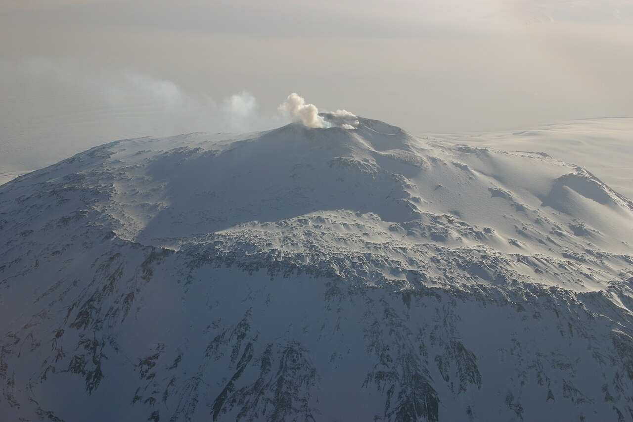
There are also volcanoes in Antarctica, some extinct and some active. At 4181 m, the highest is the extinct Mount Sidley in the Executive Committee Range. The 3794 m high Mount Erebus, located on Ross Island in the west of the Ross Sea, is the southernmost active volcano on Earth.
The volcanic Deception Island has as a special feature the only known thermal springs in Antarctica.
See also: List of mountains or elevations in Antarctica
Special features
Antarctic Ice Sheet
The most striking feature of the Antarctic continent is its almost total glaciation. The Antarctic Ice Sheet is the largest mass of ice on Earth. Around 90% of the earth's ice and 70% of the world's freshwater reserves are contained in the ice sheet, which is up to 4500 m thick. A comparable large-scale glaciation on Earth currently only exists in Greenland.
Only about 280,000 km² of the continent are ice-free, which corresponds to about two to three percent of the total area. The thickest ice sheets lie in Marie Byrd Land in the western part. At this point, only about 400 km from the coast, there is a deep subglacial trench, above whose floor the ice rises 4776 m high. The thinnest ice layers are found over the subglacial mountains in the interior of the continent, which are up to 3500 m high.
When the Antarctic ice sheet formed more than 30 million years ago, the enormous weight of the ice masses in the Earth's crust caused the continent to sink. If the ice melts, the land is expected to rise again. At the same time, if the melting were complete, the sea level would rise by about 61 meters.
The ice is in constant flow from the interior towards the coasts. Geographic lines along which the ice flows in different directions are called ice divides, analogous to watersheds.
Ice growth and outflow do not exactly balance each other out. While the ice sheet increased by an average of 112 billion tonnes between 1992 and 2001, and grew by 82 billion tonnes between 2003 and 2008, Antarctica lost about 183 billion tonnes of ice per year between 2008 and 2015, and the trend is rising. This is known as glacial melt. The Antarctic Peninsula in particular is currently affected by glacier retreat. The loss of ice became particularly drastic with the dissolution of large parts of the Larsen Ice Shelf.
Glaciology studies the structure, history and internal dynamics of the ice sheet. The aim of the investigations is to understand the future development of Antarctica and the influence of possible changes on the global climate. The most important findings here are obtained from the study of ice cores.
"Land" under and above the sea
The freshwater ice of Antarctica forms most of the "land" surface and is therefore considered part of the continent. Large parts of Antarctica lie below sea level, but are covered by ice to above sea level and are usually considered part of the continent.
The deepest point is the Bentley subglacial trench in West Antarctica (80° 19′ S, 110° 5′ W-80.3166666667-110.083333333), 2496 m below sea level. It was considered the lowest non-submarine point on Earth until 2019.
Without ice cover, the contours of the continent would look completely different from how they are usually depicted. West Antarctica would break into three major parts: the Antarctic Peninsula, Marie Byrd Land, and the Vinson Massif. East Antarctica would consist of a landmass with huge bays (e.g., Aurora Subglacial Basin and Wilkes Subglacial Basin) and fjords (e.g., at the site of today's Amery Glacier or under the South Pole). The East Antarctic landmass would be dotted with many lakes and inland seas, some of whose bottoms extend far below sea level.
Lakes under the ice
In Antarctica there are lakes of liquid water under the ice, so-called subglacial lakes. These consist primarily of fresh water.
So far, more than 150 subglacial lakes have been found. The largest of these is Lake Vostok, which was discovered in 1996 by satellite imaging near the Russian Vostok station. It is about 250 km long, 50 km wide, has a water depth of up to 1200 m and lies at a depth of 3700 to 4100 meters below the ice. The fact that the lake is not frozen despite its average temperature of -3 °C is due to the high pressure of about 30 to 40 megapascals under the ice sheet, as high pressure lowers the melting point of the ice.
In addition, Antarctica also has surface lakes (some of which are frozen all year round) such as Lake Fryxell and hypersaline lakes such as Lake Don Juan, which, with a salinity of over 40%, is considered the saltiest body of water on earth.
Rivers
Another geographical feature of Antarctica is the virtual absence of surface rivers. Antarctica's largest river, the Onyx River, is a meltwater river about 30 km long that flows only during the late Antarctic summer (February, March).
However, it was discovered in 2006 that the subglacial lakes are probably interconnected by a network of subglacial rivers and that pressure equalization and water transport takes place between them. The subglacial rivers are partly above and partly below sea level.
Discovered in 1911, the red-colored Blood Falls consists of iron-rich hypersaline water originating from a subglacial lake.
Antarctic Oases
Antarctic oases are large (largely) ice-free regions in Antarctica. The largest Antarctic oases are formed by the dry valleys in Victoria Land. Antarctic oases are rocky and often contain freshwater lakes. Antarctic flora and fauna can be explored in these areas. They are also significant for the search for fossils.
Examples:
- Bunger Oasis
- Schirmacher Oasis
Glaciers and ice streams
The Antarctic ice masses are constantly moving fluidly towards the coasts of the Southern Ocean. There are areas where the ice moves significantly faster than in adjacent areas, these are called ice streams. They are a special form of glacier.
The ice streams can be hundreds of kilometres long, 50 km wide, 2 km high, and their speed can be up to 1000 metres per year. Shear forces occur at the edges of the ice streams, deforming and softening the ice. Numerous crevasses are formed there.
Most of Antarctica's ice streams are called glaciers, but not every glacier is an ice stream. Where ice streams flow into the sea, glacier tongues ("ice tongues") can extend far out to sea.
Examples:
- Lambert Glacier - with a length of about 400 km and a width of about 100 km the longest and largest glacier on earth, the most important ice stream in East Antarctica.
- Denman Glacier - at 3500 metres below sea level, the deepest point on any continent on earth
- Axel Heiberg Glacier - discovered in 1911 by Roald Amundsen, who was the first person to reach the South Pole via it on 14 December 1911.
- Beardmore Glacier - Robert Falcon Scott reached the South Pole via this glacier on 18 January 1912.
- Pine Island Glacier - the most outflowing glacier in West Antarctica
- Mertz glacier - its tongue was rammed by iceberg B-9B in February 2010 and subsequently broke into two pieces
Ice Shelf
About 44% of Antarctica's coastline is ice shelf. These are freshwater ice sheets about 100 to 1000 meters thick that do not rest on land but float on seawater as rigid structures. They are fed by glaciers and are firmly attached to them. The glacial ice slides over the continental bedrock until it is undercut by seawater above a certain point, the touchdown line. From this line it is called an ice shelf and slides out to sea as a continuous plate. Icebergs of various sizes continually break off at its edge; this is known as "calving". Large icebergs originating from ice shelves, which are typical for Antarctica, are called tabular icebergs because of their flat shape.
The largest Antarctic ice shelves include:
- Amery Ice Shelf
- Filchner-Ronne Ice Shelf
- Fimbul Ice Shelf
- George VI Ice Shelf
- Larsen Ice Shelf
- Riiser-Larsen Ice Shelf
- Ross Ice Shelf
- Shackleton Ice Shelf
- West Ice Shelf
- Wilkins Ice Shelf
By definition, ice shelves are considered part of the continent. The exact location of their touchdown lines is difficult to determine and map, as are their constantly changing break-off edges. As a result of the calving of large icebergs, the contours of the continent and its size are constantly changing. The largest continuous iceberg ever measured, sighted in 1956, measured 335 km × 97 km and covered an area of about 31,000 km², making it larger than Belgium.
In contrast to the ice shelf, the pack ice consisting of salt water, which surrounds Antarctica over a large area, especially in winter, is not counted as part of the continent.


Questions and answers
Q: What is the southernmost continent on Earth?
A: The southernmost continent on Earth is Antarctica.
Q: How thick is the ice that covers most of Antarctica?
A: The ice that covers most of Antarctica averages at least 1.6 kilometers (1.0 miles) thick.
Q: Is anyone permanently living in Antarctica?
A: No, no humans live in Antarctica permanently. However, about 1,000 to 5,000 people live through the year at the science stations in Antarctica.
Q: What kind of animals and plants can be found in Antarctica?
A: Animals found in Antarctica include penguins, seals, nematodes, tardigrades and mites. Plant life includes some grass and shrubs, algae, lichen, fungi and bacteria.
Q: When was the first known sighting of the continent?
A: The first known sighting of the continent was in 1820.
Q: When was the Antarctic Treaty signed?
A: The Antarctic Treaty was signed in 1959 by 12 countries and since then more countries have signed it; so far 46 countries have signed it.
Related articles
Author
AlegsaOnline.com Antarctica: geography, climate, ecosystems, history and scientific significance Leandro Alegsa
URL: https://en.alegsaonline.com/art/4548
Sources
- cia.gov : "Antarctica - The World Factbook"
- ngdc.noaa.gov : "National Geophysical Data Center"
- books.google.com : Antarctia:soils, weathering, processes and environment
- worldalmanac.com : "The World at a glance: surprising facts"
- dailygalaxy.com : "Mystery of Antarctica's 15-million year-old lake"
- bbc.co.uk : bbc.co.uk/news/science-environment-15749757
- nature.com : nature.com/articles/nature10566?error=cookies_not_supported&code=2aa9a513-6552-4369-9a65-…
- bbc.co.uk : bbc.co.uk/news/science-environment-15735625
- washingtonpost.com : "Antarctica Bones Give Evidence of Continental Drift"
- nytimes.com : "Fossil Shows Cold-Blooded Frogs Lived on Warm Antarctica"
- bbc.co.uk : bbc.co.uk/news/stories-50856270
- mariner.org : "Age of Exploration: John Cook"
- nsf.gov : "Antarctica—Past and Present"
- quest.arc.nasa.gov : "Nathaniel Brown Palmer, 1799-1877" · web.archive.org