Strait of Dover
The Strait of Dover is the narrowest section of the English Channel between southeastern England and northern France, a busy maritime corridor with distinct geology, history, and transport links.
Overview
The Strait of Dover, often called the Dover Strait, is the easternmost and narrowest stretch of the English Channel. It forms the marine boundary where the channel meets the North Sea and separates southern England from northern France. Because of its narrowness and location, the strait is one of the busiest shipping lanes in Europe and an important natural and human landmark between the two countries.
Image gallery
6 Images


Location and physical characteristics
The strait occupies the sea passage between the Kent coast of England and the Pas-de-Calais coast of France. The commonly cited shortest crossing runs from the South Foreland headland near Dover, in the county of Kent, to the cape of Cap Gris-Nez near Calais in the département of Pas-de-Calais. This direct route measures roughly 33–34 km (about 20–21 mi), a distance that makes visibility of the opposite shoreline possible on clear days and has encouraged many cross-channel activities.
Geology, tides and currents
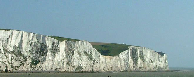
The seabed and adjacent cliffs reflect the region's chalk geology: the white cliffs on the English side and the folded chalk capes on the French side are striking landmarks. Tidal ranges are moderate but combined with strong, complex tidal streams and frequent squalls the strait can be challenging to small craft. These currents, together with shifting sandbanks and dense vessel traffic, shape navigation practices and safety planning across the passage.
Human use and transport
Historically a conduit for trade, migration and military action, the strait remains a vital corridor for ferries, freight, fishing and recreational crossings. Regular ferry services connect ports on both sides, and the nearby undersea rail link, the Channel Tunnel, provides an alternative land-based route between Kent and northern France. The channel between Dover and Calais is a focal point for cross-Channel swimmers and small-boat events; such attempts require careful planning because of distance, tides and heavy shipping traffic.
History and strategic importance
Control of the strait has been strategically important for centuries. It was a factor in medieval trade and warfare, in Napoleonic-era planning, and again during the world wars when movements of troops and supplies were concentrated on its shores and approaches. Coastal fortifications, lighthouses and wartime relics along both shores attests to its longstanding military and navigational significance.
Ecology and conservation
The shallow waters and coastal habitats support a mix of benthic communities, seabirds and migratory species. The intensity of human activity creates ongoing conservation challenges — balancing sustainable fishing, shipping safety and protection of sensitive habitats. Cross-border cooperation between the two countries addresses marine management, pollution control and species monitoring in this shared maritime environment.
Notable facts and distinctions
- The strait is the shortest sea crossing between mainland Britain and continental Europe and provides visible coastal landmarks on clear days.
- Its chalk cliffs—best known as the White Cliffs of Dover on the English side—are matched by prominent capes such as Cap Gris-Nez on the French side.
- Because of heavy traffic, planned crossings (swimming or small boats) require coordination with authorities and awareness of regulated shipping lanes.
- Further information about maritime safety, ferry timetables and local guides can be found through transport and coastal authorities in both countries (see local port websites and navigation notices).
For introductory maps and situational overviews see references to the Dover Strait and its place within the broader English Channel system. Regional descriptions and travel resources are available via local government and tourism pages for Kent, Dover, Calais and the Pas-de-Calais area. Practical distance notes and navigational guidance often reference the short crossing measured near South Foreland and its approximate nautical equivalents such as the figure in miles (mi).
Related articles
Author
AlegsaOnline.com Strait of Dover Leandro Alegsa
URL: https://en.alegsaonline.com/art/94155