
Strait of Tartary (Tatar Strait) — geography, history and importance
A long shallow strait separating Sakhalin Island from mainland Russia, linking the Sea of Okhotsk and the Sea of Japan. Important for coastal navigation, fisheries and regional geography.
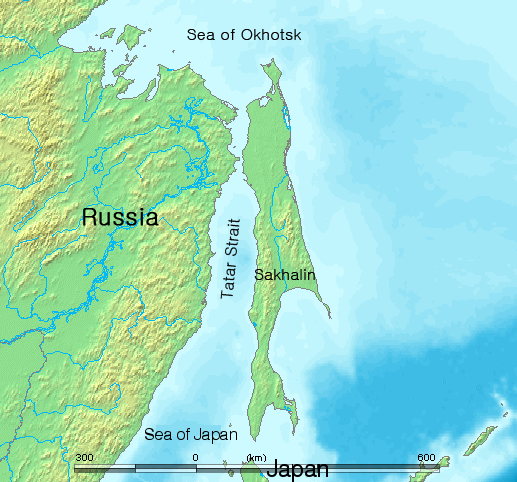
Overview: The Strait of Tartary, also called the Gulf of Tartary or Tatar Strait, is the channel that separates the Russian island of Sakhalin from mainland Asia. It forms a northern arm of the western Pacific system that connects the Sea of Okhotsk in the north with the Sea of Japan to the south and lies on the eastern margin of Russia in the North Pacific region (Pacific Ocean).
Image gallery
7 Images




Physical characteristics
The strait is long and relatively shallow compared with open ocean passages. Its total length is on the order of several hundred kilometres, commonly cited as about 900 km end to end. Water depths are generally modest—typically only a few metres to a few tens of metres—so it is classified as a shallow strait. The channel narrows at points to only a few kilometres across; the commonly quoted narrowest width is about 7.3 km. These physical constraints affect tidal flows, currents and ice conditions seasonally.
History and naming
The name "Tartary" (and variants such as Tatar or Tartar) reflects older European cartographic usage for broad regions of northern and central Asia. Over centuries the waterway has appeared on Russian, European and East Asian maps under several names. Coastal communities, explorers and mariners have long used the strait as a coastal route, and it features in accounts of exploration, mapping and regional trade.
Uses, ecology and navigation
The Strait of Tartary supports important fisheries and coastal ecosystems, including migratory fish and marine mammals adapted to the cold-temperate environment. Seasonal ice can restrict navigation in winter, although many stretches remain usable for coastal shipping in warmer months. Local ports and fishing settlements on both the Sakhalin and mainland sides rely on the channel for transport, resource access and regional commerce.
Notable facts and distinctions
- The strait is distinct from wider ocean passages because of its combination of length and shallow depth, which modifies tides and currents compared with the open Pacific.
- From a geopolitical and infrastructural perspective, various proposals have been discussed over time for fixed links (bridges or tunnels) at narrow crossings to improve connections between Sakhalin and the mainland, though none has resulted in a permanent cross-strait fixed link.
- Because the strait links two marginal seas, it is an important conduit for water exchange, sediment transport and biological migration between the Sea of Okhotsk and the Sea of Japan, influencing coastal environments on both sides.
For further geographic context and contemporary navigation details see region-specific resources and nautical guides that cover the Strait of Tartary and adjacent seas.
Questions and answers
Q: What is the Strait of Tartary?
A: The Strait of Tartary is a strait in the Pacific Ocean that divides the Russian island of Sakhalin from mainland Asia.
Q: What bodies of water does the Strait of Tartary connect?
A: The Strait of Tartary connects the Sea of Okhotsk on the north with the Sea of Japan on the south.
Q: How long is the Strait of Tartary?
A: The Strait of Tartary is 900 km long.
Q: What is the depth of the Strait of Tartary?
A: The Strait of Tartary is 4-20 meters deep.
Q: At its narrowest point, how wide is the Strait of Tartary?
A: The Strait of Tartary is 7.3 km wide at its narrowest point.
Q: What are some other names for the Strait of Tartary?
A: Some other names for the Strait of Tartary include Gulf of Tartary, Gulf of Tatary, Tatar Strait, and Tartar Strait.
Q: Where is the Strait of Tartary located?
A: The Strait of Tartary is located in the Pacific Ocean, dividing the Russian island of Sakhalin from mainland Asia.
Related articles
Author
AlegsaOnline.com Strait of Tartary (Tatar Strait) — geography, history and importance Leandro Alegsa
URL: https://en.alegsaonline.com/art/94162
Sources
- ceebd.co.uk : Vanino Commercial Sea Port
- sasco.ru : Vanino-Kholmsk
- tools.wmflabs.org : 52°11′00″N 141°37′00″E / 52.18333°N 141.61667°E / 52.18333; 141.61667