
Piri Reis — Ottoman admiral, navigator and cartographer
Piri Reis (c.1465–1554/55) was an Ottoman admiral and mapmaker best known for his early 16th‑century world maps and the Kitab‑i Bahriye, a detailed guide to Mediterranean navigation.
Piri Reis (born Hadji Muhiddin Piri ibn Hadji Mehmed, c. 1465–1470; died c. 1554–1555) was an Ottoman naval officer and cartographer whose surviving charts and writings rank among the most important navigational documents produced in the early 16th century. He served in the fleet of the Ottoman Empire and combined practical seamanship with an interest in compiling and adapting the best available geographic knowledge of his day. Modern attention centers on his 1513 world map fragment and his maritime manual, the Kitab‑i Bahriye (Book of Navigation).
Image gallery
8 Images
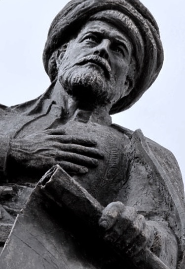


Life and naval career
Piri came from Gallipoli on the Aegean coast and was closely connected to the Ottoman seafaring world; he is commonly described as the nephew and companion of the corsair-admiral Kemal Reis. He rose through naval ranks and took part in campaigns and escort missions in the Mediterranean and the Atlantic approaches. Contemporary records are sparse and dates vary between sources, but scholars generally place his activities in the late 15th and first half of the 16th century. Accounts differ about his death, which occurred in the mid‑1550s; some sources indicate he was executed after falling from favor, while others record his passing without that detail.
Major works and cartographic practice
Piri Reis is known for two types of work: large‑scale charts and an illustrated navigation handbook. The most famous surviving artifact is the fragment of a world map dated 1513. That map combines Atlantic coastal outlines with decorative elements and marginal notes identifying the map's sources. Piri himself recorded that he used many earlier charts — including Portuguese and Spanish maps and the accounts of western sailors — to compile his depiction of the newly encountered Americas. A later map, dated 1528, survives only in part and shows North Atlantic coasts such as Greenland, Newfoundland and parts of eastern North America.
His Kitab‑i Bahriye is a practical and richly illustrated guide to Mediterranean coasts, harbors, currents and navigation. It contains portolan‑style coastal charts, compass markings and sailing directions intended for pilots and shipmasters. The book blends firsthand observation with material drawn from a wide range of cartographic and pilot traditions, making it both a navigational manual and a record of contemporary geographic knowledge.
Methods, sources and distinguishing features
Piri worked in the portolan tradition, which emphasized coastlines, ports and bearings for practical navigation. His maps are notable for annotated source lists and for combining information from Islamic, Iberian and other European mapmakers. He cited Columbus and other early transatlantic navigators among his sources, and his mapmaking shows an awareness of the compass roses, rhumb lines and scale conventions used by Mediterranean pilots. Artistically, his maps and the Kitab‑i Bahriye include descriptive images of cities, fortifications and coastal features that augment their practical value.
Significance and modern reception
Piri Reis occupies an important place in the history of cartography because his work preserves early 16th‑century geographic knowledge and illustrates how information moved between maritime cultures. His 1513 map fragment is housed in an imperial archive and has been repeatedly studied by historians of science and navigation. Scholars use his manuscripts to trace the diffusion of Portuguese, Spanish and Mediterranean charting practices and to understand naval logistics and coastal knowledge in the early Ottoman navy. Some popular claims about his maps — for example, assertions of highly improbable ancient knowledge of polar or Antarctic coasts — are not supported by mainstream scholarship and should be treated with caution.
Selected works
- 1513 world map fragment — the best‑known surviving piece, showing Atlantic coasts and annotated source material.
- 1528 world map fragment — a later sheet showing parts of the North Atlantic and eastern North American coasts.
- Kitab‑i Bahriye (Book of Navigation) — a navigational manual with charts, coastal descriptions and sailing instructions for Mediterranean pilots.
Further reading and links
For primary sources, images and modern commentary, consult museum descriptions and scholarly treatments. The list below provides entry points to collections and studies that discuss Piri Reis and his maps:
- Link 1
- Link 2
- Link 3
- Link 4
- Link 5
- Link 6
- Link 7
- Link 8
- Link 9
- Link 10
- Link 11
- Link 12
- Link 13
- Link 14
- Link 15
- Link 16
- Link 17
- Link 18
- Link 19
This article summarizes widely accepted facts about Piri Reis: his role in Ottoman navigation, the character of his surviving maps, and his lasting importance to maritime history. For in‑depth analysis, consult the specialized literature and manuscript facsimiles available through the links above.
Related articles
Author
AlegsaOnline.com Piri Reis — Ottoman admiral, navigator and cartographer Leandro Alegsa
URL: https://en.alegsaonline.com/art/77081