Turkey (Republic of Türkiye)
Transcontinental country bridging southeastern Europe and western Asia, noted for a layered history from ancient Anatolian civilizations to the Ottoman Empire and a modern republic with diverse culture, economy and tourism.
Overview
Turkey, officially the Republic of Türkiye, is a transcontinental nation that occupies most of the Anatolian Peninsula in western Asia and a smaller portion in southeastern Europe. It borders seas and countries on three continents and sits at a strategic crossroads between Europe and Asia. Ankara is the capital and administrative center, while Istanbul—formerly Constantinople—is the country’s largest city and its historic, cultural and economic hub.
Image gallery
6 Images


Geography and environment
Turkey’s landscape ranges from coastal plains and fertile river valleys to high plateaus and mountainous regions. It has extensive coastlines on the Black Sea, the Aegean Sea and the Mediterranean Sea. Climatic zones vary by region: coastal areas enjoy a Mediterranean climate, central Anatolia is drier and continental, and the northeast has humid and cooler conditions. This environmental variety supports diverse agriculture, forestry and animal husbandry across the provinces.
History and development
The territory now called Turkey has been inhabited for millennia and was home to ancient peoples such as the Hittites, Greeks and various Anatolian cultures before incorporation into the Roman and later Byzantine Empires. After the rise of the Ottoman Empire in the late medieval period, the region became a major political and cultural center for centuries. The modern republic was established in 1923 following the collapse of the Ottoman state and a successful war of independence; its founding brought major political, legal and social reforms aimed at modernization and secular governance.
Government, society and culture
Turkey is a republic with a unitary administrative structure divided into provinces. Its society reflects a blend of traditions and influences from Anatolian, Balkan and Middle Eastern cultures. Turkish is the official language, and the population practices a variety of cultural and religious traditions. Urban centers, particularly Istanbul, are notable for historic architecture, museums, performing arts, and a culinary heritage that is regionally varied and internationally recognized.
Economy and infrastructure
The Turkish economy combines agriculture, industry and services. Fertile lands produce cereals, fruits, vegetables and cotton, while livestock and forestry contribute to rural livelihoods. Manufacturing includes textiles, automotive assembly, electronics and increasingly aerospace and defense industries. Tourism is a major source of foreign exchange, supported by beaches, ancient ruins and vibrant cities. Transport links—roads, railways, airlines and ports—connect Turkey domestically and to neighboring regions.
Importance and notable facts
Turkey’s geographic position gives it strategic significance in regional politics, trade and energy transit. It is a member of international organizations and plays an active diplomatic role between Europe, Asia and the Middle East. Archaeological sites, Byzantine and Ottoman monuments, and coastal resorts attract many visitors each year. The country’s history, language and cultural productions continue to influence the wider region.
External resources
- Location and maps (LINK_1)
- Anatolian peninsula overview (LINK_2)
- Western Asia context (LINK_3)
- Black Sea details (LINK_4)
- Georgia border information (LINK_5)
- Armenia relations (LINK_6)
- Azerbaijan connections (LINK_7)
- Iran–Turkey ties (LINK_8)
- Iraq border notes (LINK_9)
- Syria and southern border (LINK_10)
- Mediterranean coast (LINK_11)
- Aegean Sea and islands (LINK_12)
- Greece neighbor relations (LINK_13)
- Bulgaria and northwest border (LINK_14)
- Republic governance (LINK_15)
- Administrative provinces (LINK_16)
- Ankara, the capital (LINK_17)
- Istanbul’s role (LINK_18)
- Constantinople history (LINK_19)
- Post–World War I period (LINK_20)
- Ottoman heritage (LINK_21)
- Hittite and ancient Anatolia (LINK_22)
- Roman period sites (LINK_23)
- Byzantine legacies (LINK_24)
- Christian history connections (LINK_25)
- Climate and regions (LINK_26)
- Traditional cuisine (LINK_27)
- Agricultural production (LINK_28)
- Livestock and rural economy (LINK_29)
- Forestry resources (LINK_30)
- Electronics and industry (LINK_31)
- Textile and manufacturing sectors (LINK_32)
Geography
Location
|
|

Turkey geographically spans two continents. Anatolia, the Asian part of the Turkish territory, occupies about 97% of the area. The European part in the northwest (Eastern Thrace) covers about 3% of the area, which also includes the main part of the metropolis of Istanbul.
With a coastline of around 7200 km, Turkey borders the Aegean Sea to the west, the Mediterranean Sea to the south and the Black Sea to the north. The Sea of Marmara lies between the Aegean and Black Seas and is connected to each of them by a strait: in the west the Dardanelles, which are about 65 kilometres long, and in the east the Bosporus. The metropolis of Istanbul lies on the Bosphorus.
The land border with the eight neighboring countries has a total length of 2816 km. In the northwest Turkey borders Greece (192 km border) and Bulgaria (223 km), in the northeast Georgia (273 km), Armenia (311 km), Azerbaijan (exclave and autonomous republic of Nakhichevan, 17 km), in the east Iran (534 km) and in the south Iraq (367 km) and Syria (899 km). The politically divided island of Cyprus, with the Republic of Cyprus and the internationally unrecognized Turkish Republic of Northern Cyprus, is located about 70 kilometers from the southern coast. Also not far from the Turkish mainland are the Greek islands of Chios, Kos, Symi and Rhodes.
The relocated tomb of Suleiman Shah (previously at Qalʿat Dschaʿbar) near the Syrian city of Sarrin is (as of mid-2014) an official exclave. It was guarded as a territory by Turkish soldiers. In February 2015, a commando unit of the Turkish armed forces moved the tomb again and dragged the tomb.
Geology
Geologically, Turkey is part of the Alpidic mountain belt. It lies largely on the Anatolian Plate, which borders the Eurasian Plate to the north and east, the Arabian Plate to the south, and the African Plate to the southwest. Due to the North Anatolian Fault, a transform fault, northern Turkey in particular is one of the most earthquake-prone regions on Earth, having been shaken by earthquakes several times in recent decades. Since a certain chronological east-west sequence of earthquakes can be observed in northern Turkey, experts suspect that Istanbul will also be affected by a major quake in the foreseeable future. The last major quakes in Kocaeli province, such as the 1999 Gölcük earthquake, were less than 100 km from Istanbul.
Landscape
→ Main article: Geographical areas of Turkey
Turkey is geographically divided into seven areas or regions. Four regions are named after the adjacent seas: Black Sea region, Marmara region, Aegean region, and Mediterranean region. Three regions are named after their location in Anatolia: Central Anatolia, Eastern Anatolia and Southeastern Anatolia. These regions differ greatly in terms of vegetation and weather conditions.
The Marmara region encloses the Sea of Marmara and thus lies partly in Europe and partly in Anatolia, which belongs to Asia. The European part in the north of the Sea of Marmara is the Turkish Thrace (Eastern Thrace). The Meriç River forms the border with Greece. The landscape of the Marmara region is hilly and covered with bushes and forests. The fertile arable land gives way to a steppe landscape in the east. The metropolitan region of Istanbul forms the economic centre of Turkey. The megacity of Bursa is a health resort and famous for its sulphur and thermal springs; it lies at the foot of the Uludağ Mountains. The mountain is a popular destination for excursions all year round.
The Aegean region is also intensively used for agriculture. The strongly hilly landscape stretches along the west coast between Çanakkale and Bodrum. The coastal region is one of the most touristically developed regions of Turkey. Besides cypresses and olive trees, grapevines characterize the landscape. In this region there are many ancient sites from the time of the Greek settlement, e.g. Troy, Assos (Behramkale), Pergamon (Bergama), Ephesus (Efes), Priene, Miletus, Didyma and Euromos.
The Black Sea region covers the northern coastal strip of Turkey. It is characterized by a mild, humid climate, and large forests stretch across its mountainous landscape. Tea, tobacco, corn and hazelnuts are grown on the very fertile soil.
The Central Anatolian region includes the inner Anatolian plateaus. Here lie the salt lake Tuz Gölü and mountain ranges, which in places rise up to 3900 meters. To the east lies Cappadocia, famous for its tufa dwelling caves and rock-hewn churches in mountain cones up to 2000 metres high. Inner Anatolia is predominantly characterized by a steppe landscape, much of which is not natural, however, but caused by human intervention such as deforestation and livestock browsing. It is one of the driest areas of Anatolia; in the region around Tuz Gölü the climate has semi-desert features. Therefore, agricultural use in this region is not as intensive as in the previously mentioned regions. However, the seasonal distribution of precipitation, which is favourable for crops, especially cereals, with a rainfall maximum in spring and early summer, allows rain-fed agriculture throughout without compulsory artificial irrigation. Therefore, largely all areas are used for agriculture whose soils are not destroyed by karstification or erosion. Mainly wheat, barley, legumes, especially chickpeas, and fruits are cultivated here. The climate of this region is characterized by very warm, dry summers with cool nights. In winter, very low temperatures down to -20 degrees Celsius can be reached. The average temperatures are similar to the winters in Germany, but shorter. In Central Anatolia you can find warmth-loving, but cold-resistant plants from the Mediterranean region, such as fig, pomegranate or mulberry trees. Winegrowing, or cultivation of table grapes, is also practiced there.
Some of the highest mountains in Turkey, such as Mount Ararat and Mount Süphan Dağı, are located in eastern Anatolia. The headwaters of the Euphrates, the Murat and the Karasu, are also found here, as well as the upper reaches of the Aras River, which flows eastward past Ararat towards the Caspian Sea. Lake Van, 1640 meters high, as the largest inland lake in the country, is also located in this region. The largest cities are Elazığ, Erzincan, Erzurum, Malatya and Van.
The Mediterranean region is bordered by the Taurus Mountains to the north and the Amanos Mountains to the east. The main crops grown in this region are citrus fruits, bananas, tomatoes, peanuts and cotton.
Southeast Anatolia is the oldest cultural region of Turkey. It is surrounded by the Taurus Mountains. Here run the two rivers Euphrates and Tigris. Agriculturally this region is used by wheat, barley, wine, olive and pistachio cultivation. In addition to mountain ranges, the area east of the Euphrates is characterized by a high plateau. As part of the South-East Anatolia Project, numerous dams have been built along the Euphrates and Tigris rivers; some are still under construction (→ Euphrates#Dams and Tigris#Dams).
Hydrologically, Turkey is characterized by its relief and especially the Taurus Mountains in the south and the Armenian Highlands in the east. Most of Anatolia drains to the Black Sea via major rivers such as Kızılırmak and Sakarya. The Mediterranean and Aegean Seas, on the other hand, have comparatively small drainage basins. Notable rivers that flow into the Aegean include the Great and Small Meanders and the Gediz, while larger rivers into the eastern Mediterranean exist only in the area of the Gulf of Iskenderun with the Seyhan, Ceyhan, and Orontes (Asi), the latter originating in Lebanon and subsequently flowing through Syria. Inland, in turn, there are several terminal basins to the west and east, whose rivers flow into larger saline terminal lakes such as Tuz Gölü, Lake Van, and Burdur Gölü. Finally, the eastern part of the country drains via the Aras and its tributaries to the Caspian Sea and via the Euphrates and Tigris to the Persian Gulf.
| Highest mountains in Turkey
See also: List of mountains in Turkey | Most important rivers in Turkey
See also: Category:River in Turkey | Turkey lakes
| Major islands of Turkey
See also: Category:Island (Turkey) |
Climate
· 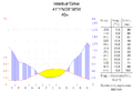
Istanbul climate diagram
· 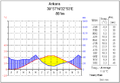
Ankara climate chart
· 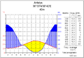
Antalya climate diagram
· 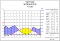
Climate diagram of Van
| The climate data of Turkey depending on the region | |||||
| Region | Average temperature (°C) | Maximum temperature (°C) | Lowest temperature (°C) | Average humidity (%) | Average precipitation (mm) |
| Marmara Region | 13,5 | 44,6 | −27,8 | 71,2 | 569,0 |
| Aegean region | 15,4 | 48,5 | −45,6 | 60,9 | 654,3 |
| Mediterranean region | 16,4 | 45,6 | −33,5 | 63,9 | 706,0 |
| Black Sea region | 12,3 | 44,2 | −32,8 | 70,9 | 828,5 |
| Central Anatolia | 10,6 | 41,8 | −36,2 | 62,6 | 392,0 |
| Eastern Anatolia | 9,7 | 44,4 | −45,6 | 60,9 | 569,0 |
| Southeast Anatolia | 16,5 | 48,4 | −24,3 | 53,4 | 584,5 |
flora and fauna
→ Main article: Flora and vegetation of Turkey
The flora of Turkey is considered the most diverse and varied in the Middle East. More than 9000 species from over 850 genera have now been identified. About one third of these species are endemic. Reasons for this extremely high rate of endemism are the coincidence of different phytogeographical regions, climatic diversity and a mountainous landscape; factors that allow a high degree of differentiation. The genera Verbascum and Astragalus have their distribution focus here. However, many endemic species are endangered. The central steppe areas are dominated by thorn pads and shrubs, e.g. thistles, which withstood the centuries of grassing by the cattle nomads. In the north, especially on the Black Sea coast, there are extensive coniferous forests and commercially used hazelnut, maize and tea plantations, in the south rather fruit and cotton plantations.
Many species of small game and wild boar are also native, although their population is constantly being decimated by hunting. Cattle, horses, buffalo, sheep and goats are the main livestock. The camel population has declined steadily in recent decades; today they are bred primarily for sporting competitions and no longer as load carriers.
On the Turkish coast you can also meet a variety of fish species and dolphins. Occasionally you can also meet different species of sharks in the sea, but they tend not to come close to the coast. The monk seal, thought to be extinct in Europe, can now be found again on the Aegean coast of Turkey and Greece.
The largest predators still living in Turkey today include the brown bear, wolf, golden jackal and Eurasian lynx. The striped hyena lives in the southeast of the country. Occasional creeping and wild cats are also encountered, and desert monitor lizards and ichtneumons in the southeast of the country. Over time, predators have been hunted and exterminated. The last Asiatic lion was killed in 1870. The last Caspian tiger was shot in 1970. The Anatolian leopard, declared extinct in 1974, was rediscovered in the Black Sea region in 2013 after several years of research.
Turkey is a breeding and wintering ground for numerous bird species. South of Bandırma - in Kuşcenneti National Park - is a well-known bird paradise, where pelicans, wild ducks, storks, cormorants, nightingales and pheasants have made their home. Important colonies of pink flamingos are located in the interior and south of the country.
Nature reserves
1.3% of Turkey's land area is protected. This includes ten coastal protected areas, 18 nature reserves and 41 national parks, two of which have been declared World Heritage Sites by UNESCO. Turkey also shares in the European Green Belt and the European part of the country is located in the Blue Heart of Europe.
However, the low financial resources of the Ministry of Environment currently prevent sufficient protection of the areas. Moreover, no national park or protected area in Turkey meets the international IUCN categories.
Beaches and landscapes
A total of 235 (as of 2007) beaches in Turkey have been awarded the Blue Flag, which is awarded each year to beaches and marinas that have maintained a consistently high standard of bathing water quality during the previous season.
The south coast between Antalya in the west and Cape Anamur in the east of Turkey, also known as the Turkish Riviera, is one of the country's tourist centres. Next to Antalya, Alanya is the most important city. In addition, the southern Aegean coast is very popular for beach holidaymakers. Another very popular seaside resort is Bodrum. Besides the debauched nightlife Bodrum is famous for its medieval crusader castle (Bodrum Kalesi). Fethiye is known for its bays, islands and beaches. Nearby is Myra, where the Church of St. Nicholas is located alongside Lycian rock tombs.
Cappadocia is a landscape in central Anatolia. One of the most famous places is Göreme with its cave churches carved out of soft tuff. The area is made up of tuff that weathers slowly due to low rainfall and wind. Harder rock remains, creating fairy chimneys.


Questions and answers
Q: What is the official name of Turkey?
A: The official name of Turkey is the Republic of Türkiye.
Q: How many provinces are there in Turkey?
A: There are 81 provinces in Turkey.
Q: What is the currency used in Turkey?
A: The currency used in Turkey is called Turkish Lira.
Q: What city serves as the capital and cultural center of modern day Turkey?
A: The capital city of modern day Turkey is Ankara, which also serves as its cultural center, while Istanbul on the European side acts as its economic center.
Q: Which ancient civilizations occupied what is now known as present-day Turkey?
A: Ancient civilizations such as the Hittites, Roman Empire and Byzantine Empire have all occupied what is now known as present-day turkey.
Q: What makes turkey a popular tourist destination?
A: Turkey's varied climate which allows for different food crops to grow and hundreds of kilometers of beautiful beaches on its Aegean and Mediterranean coasts make it a popular tourist destination for visitors from around the world
Related articles
Author
AlegsaOnline.com Turkey (Republic of Türkiye) Leandro Alegsa
URL: https://en.alegsaonline.com/art/102095
Sources
- ethnologue.com : Ethnologue Languages of the World – Turkey
- tuik.gov.tr : "The Results of Address Based Population Registration System, 2018"
- turkstat.gov.tr : "Annual growth rate and population density of provinces by years, 2007–2015"
- imf.org : "World Economic Outlook Database, April 2019"
- data.worldbank.org : "GINI index (World Bank estimate)"
- hdr.undp.org : "2018 Human Development Report"
- bbc.com : "Who are Kurdistan Workers' Party (PKK) rebels?"
- ncbi.nlm.nih.gov : "Alu insertion polymorphisms and an assessment of the genetic contribution of Central Asia to Anatolia with respect to the Balkans"
- hurriyetdailynews.com : University numbers on the rise in Turkey
- nytimes.com : "More Than 570 Die in Quake in Turkey"
- springerlink.com : "The Erzincan (Turkey) Earthquake (Ms 6.8) of March 13, 1992 and its Aftershock Sequence"
Social situation
The state provides primary health care for all citizens. In 2007, there were 1.23 doctors per 1000 inhabitants. Life expectancy in Turkey was 74.8 years (71.5 years for men and 78.1 years for women) in the period from 2010 to 2015. The United Nations Development Programme ranks Turkey among the countries with very high human development.
Development of life expectancy in Turkey since 1950 according to UN
Period
Life expectancy in years
Period
Life expectancy in years
1950–1955
41,01
1985–1990
63,04
1955–1960
43,69
1990–1995
65,49
1960–1965
47,22
1995–2000
68,49
1965–1970
50,78
2000–2005
71,37
1970–1975
53,75
2005–2010
73,37
1975–1980
57,05
2010–2015
74,83
1980–1985
60,22
Source: UN
According to a 2014 Credit Suisse study, Turkey has a Gini coefficient of 0.84, making it a country with a "high degree of wealth inequality. Wealth inequality increased between 2002 and 2014, with the share of the richest one percent of the Turkish population rising from 39.4 percent of total wealth to 54.3 percent during this period. According to Forbes, there were 29 billionaires in Turkey in 2017.