Hurricane Bob (1985)
A mid‑July 1985 hurricane that formed in the eastern Gulf of Mexico, struck southwestern Florida as a tropical storm, later became a hurricane and made landfall near Beaufort, South Carolina, causing flooding and damage.
Overview
Hurricane Bob was an early summer tropical cyclone of the 1985 Atlantic season that affected parts of the southeastern United States in late July. The system began as a tropical disturbance in the central Atlantic and, after moving westward, developed into a named storm in the eastern Gulf of Mexico on July 21. It was the second tropical storm and the first hurricane of the 1985 Atlantic hurricane season, and it produced periods of heavy rain, localized flooding, wind damage, and several tornadoes during its brief existence.
Image gallery
7 Images


Meteorological history
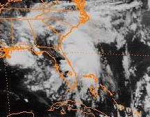
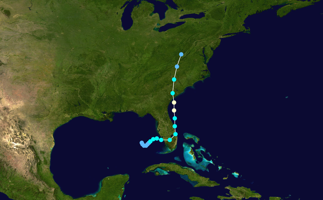
The storm originated from a typical westward‑moving tropical wave that organized while over warm waters. Forecasters tracked the disturbance as it entered the eastern Gulf of Mexico, where it acquired sufficient convection and circulation to be classified as a tropical cyclone on July 21. The system initially moved eastward and made a short landfall in southwestern Florida while still a weak tropical storm, bringing heavy rainfall to portions of the peninsula. After moving offshore, the cyclone turned northward and intensified, reaching hurricane strength on July 24 before making a subsequent landfall near Beaufort, South Carolina. The circulation weakened rapidly over land and was absorbed by a mid‑latitude frontal trough over eastern West Virginia on July 26.
Characteristics and notable meteorological features
Bob displayed several features common to Gulf‑and‑Atlantic storms of midsummer: genesis from a tropical wave (tropical wave), interaction with warm coastal waters, a period of reintensification after initial land interaction, and eventual merger with a frontal system. Its track — striking Florida as a tropical storm and then continuing to intensify before a second landfall along the Carolina coast — illustrates how coastal waters and steering currents can quickly change a storm's strength and direction. The system was designated as a hurricane on July 24 during this northward turn, and it was one of a group of storms that contributed to a busy 1985 season (1985 Atlantic hurricane season).
Impacts
Bob produced widespread rainfall across the Gulf Coast and southeastern states. Rainfall totals in some locations were substantial, with a reported maximum exceeding 20 inches (about 508 mm) in Everglades City, Florida. In many areas the heaviest rains were considered beneficial because they helped relieve dry conditions that had persisted earlier in the year. Overall monetary damage from the storm was estimated at about $20 million, and there were five indirect fatalities attributed to the event.
- Florida: heavy rains and localized flooding, with the highest totals in parts of the Everglades and on the peninsula.
- South Carolina: wind and rain near the point of landfall with generally limited structural damage in most communities; storm surge impacts were localized.
- Virginia and inland states: the cyclone's remnants spawned several tornadoes (tornadoes), including one that destroyed two houses, highlighting the risk of tornadic activity in tropical cyclone remnants.
Aftermath and significance
While Bob was not among the most destructive hurricanes of the decade, it is notable for its rapid change in intensity after passing southwest Florida and for being part of a year with an unusually high number of U.S. hurricane landfalls. The storm served as a reminder that even storms that make an initial landfall as a tropical storm can re‑strengthen and pose renewed threats to coastal communities. Emergency managers and meteorologists used post‑event analyses to refine warnings and preparedness guidance for similar near‑shore systems. For additional official summaries and archive material, consult contemporary season reports and regional storm summaries available from meteorological agencies and repositories (tropical storm/hurricane references, Gulf of Mexico synoptic summaries).
Related articles
Author
AlegsaOnline.com Hurricane Bob (1985) Leandro Alegsa
URL: https://en.alegsaonline.com/art/45838
Sources
- aoml.noaa.gov : "Hurdat Data for Tropical Cyclones 1851-2008"