Hurricane Charley (August 2004)
A rapidly intensifying Category 4 hurricane in August 2004 that produced a narrow corridor of extreme wind damage across southwestern Florida and caused significant economic loss and fatalities in the United States.
Overview: Hurricane Charley was a compact but intense Atlantic hurricane that formed in early August 2004 and persisted from August 9 to August 15. It was the second hurricane and second major (Category 3 or higher) storm of the 2004 Atlantic hurricane season. Charley reached peak sustained winds near 150 mph, making it a Category 4 system on the Saffir–Simpson scale; its rapid strengthening over the Gulf of Mexico attracted close attention from forecasters (wind summary).
Image gallery
10 Images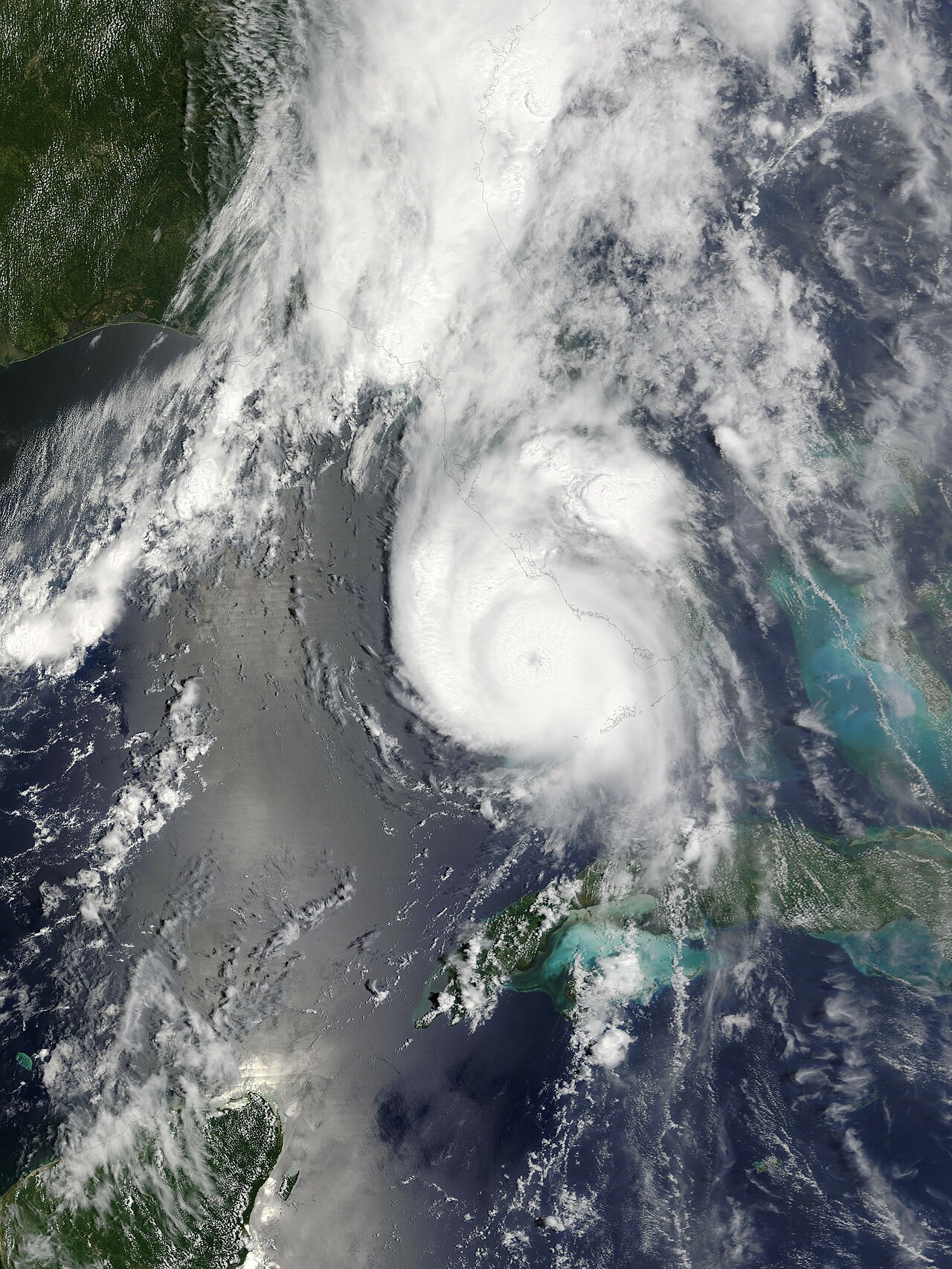


Meteorological history and characteristics
Charley developed from a tropical disturbance in the western Caribbean and accelerated north-northeastward as it crossed warm waters. The cyclone underwent a period of pronounced rapid intensification before moving over the southwestern Florida coast. It featured a relatively small eye and a compact wind field, concentrating the strongest winds in a narrow corridor near the eyewall. These characteristics made its peak effects highly localized but very severe.
Path, landfall and affected areas
The hurricane made its principal U.S. landfall along southwestern Florida, striking near the Port Charlotte and Punta Gorda area after crossing parts of the western Caribbean. Before reaching Florida it produced heavy rains and gusty winds over portions of the Greater Antilles and nearby islands. Following landfall Charley moved inland across the Florida peninsula and weakened while producing damaging winds far inland along its trajectory.
Impact and damage
Charley inflicted intense, localized damage where the eyewall crossed the coast. In the United States the storm was responsible for multiple fatalities and extensive destruction to homes, commercial buildings and infrastructure. Wind damage included roof failures, structural collapse of weaker buildings, uprooted trees and widespread utility outages. Coastal areas experienced storm surge and wave action that compounded the effects of high winds. Official U.S. assessments attributed ten deaths to the storm and estimated total damages in the billions (reported as $15.4 billion in 2004 USD), making Charley one of the costliest U.S. hurricanes of that period.
Response, recovery and lessons
State and local emergency management agencies activated evacuations, sheltering and search-and-rescue operations. Federal assistance and disaster declarations supported recovery, debris removal and rebuilding. The event highlighted challenges in forecasting and communicating the risks of rapidly intensifying, compact hurricanes, and it reinforced planning measures for building standards, evacuation routing and public messaging for high-impact, narrow-track storms (after-action summaries).
Meteorological and historical significance
Charley was notable for its rapid intensification and unusually small, intense core. Because the most severe winds were restricted to a relatively narrow region, damage patterns were sharply localized compared with larger storms. The hurricane was the strongest to make U.S. landfall since Hurricane Andrew in 1992 at the time, and it formed part of an active 2004 season that included several damaging hurricanes. Researchers and emergency managers studied Charley to improve forecasting of rapid intensification and to refine building codes and preparedness strategies (intensity data, regional reports).
- Notable facts: compact wind field, rapid intensification, Category 4 landfall.
- Primary effects: extreme localized wind damage, storm surge, flooding and extended power outages.
- Legacy: influenced forecasting practices and preparedness for intense, fast‑moving hurricanes.
Related articles
Author
AlegsaOnline.com Hurricane Charley (August 2004) Leandro Alegsa
URL: https://en.alegsaonline.com/art/45850
Sources
- nhc.noaa.gov : The deadliest, costliest and most intense United States tropical cyclones from 1851 to 2010 (and other frequently requested hurricane facts)
- nhc.noaa.gov : Hurricane Sandy: October 22 – 29, 2012 · webcitation.org
- nws.noaa.gov : Hurricane/Post-Tropical Cyclone Sandy, October 22–29, 2012 · webcitation.org