West Virginia
![]()
The title of this article is ambiguous. For other meanings, see West Virginia (disambiguation).
West Virginia (pronounced [![]()
![]() wɛst vɝːd͡ʒɪnjə]) is a state in the Appalachian region of the United States, popularly known as The Mountain State. It is bordered by Virginia to the southeast, Kentucky to the southwest, Ohio to the northwest, Pennsylvania to the north, and Maryland to the northeast. West Virginia, which seceded from Virginia in the War of Secession, is also known as a mining state as well as for its labor struggles and relative poverty.
wɛst vɝːd͡ʒɪnjə]) is a state in the Appalachian region of the United States, popularly known as The Mountain State. It is bordered by Virginia to the southeast, Kentucky to the southwest, Ohio to the northwest, Pennsylvania to the north, and Maryland to the northeast. West Virginia, which seceded from Virginia in the War of Secession, is also known as a mining state as well as for its labor struggles and relative poverty.

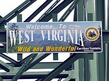
Border sign on Highway 52
Geography
Geographical position
West Virginia is located in the eastern United States between Virginia to the southeast and south, Kentucky to the southwest, Ohio to the northwest, and Pennsylvania and Maryland to the northeast. The northernmost part of the state forms a narrow strip between Ohio and Pennsylvania and is therefore called the "Panhandle". The border with Ohio is formed by the headwaters of the Ohio River, and the border with Maryland is formed by the North Branch of the Potomac River.
The state is located entirely in the Appalachian Mountains, which is why it is nicknamed the "mountain state". From northwest to southeast, it is divided into the Allegheny Plateau (part of the Appalachian Plateau), the Allegheny Mountains and the Valley and Ridge zone. The highest elevation is Spruce Knob at 1482 m, and the average elevation of West Virginia is 455 m above sea level, which is the highest for any state east of the Mississippi.
Rivers and lakes
The Eastern North American Continental Divide cuts through West Virginia. The easternmost part of the state is part of the Potomac River drainage basin, which drains directly to the Atlantic Ocean; the larger western part drains to the Gulf of Mexico via the Ohio River and the Mississippi River.
Major tributaries of the Ohio in West Virginia are Wheeling Creek, Little Kanawha River with its reservoir Burnsville Lake, Kanawha River with its tributary Elk River, and the Big Sandy River with its tributary Tug Fork. Big Sandy River and Tug Fork form the border between West Virginia and Kentucky, the Tug Fork forms a small part of the border between West Virginia and Virginia.
History
West Virginia's formation is unique in the history of the United States: Until the War of Secession, it was a part of Virginia. From the time of the settlement of this part of the country, however, there had been political differences between the rather poorer small farmers of this mountainous region and the plantation owners on the plains, who were dominant in the politics of the state. For their part, after the outbreak of the American Civil War and Virginia's secession from the Union, the western counties seceded from their parent state on April 27, 1861. Representatives of these counties formed a new government, which took up residence in Alexandria, Virginia. They had been authorized to do so by a note from Abraham Lincoln dated December 31, 1862.
Virginia at this time had two legislatures, one which had voted to join the Confederacy, and a counter-parliament which was loyal to the Union, and therefore to the Northern States. Under the Constitution of the United States it is not lawful to admit any part of a territory into the Union without the consent of that State. Such consent was given by Virginia's counterparliament on May 13, 1862, so that the Constitution was formally satisfied. Since the counterparliament consisted almost entirely of delegates from the western part of Virginia, strong doubts arose, even with Abraham Lincoln, about the constitutionality of admitting West Virginia into the Union; but they were ignored for strategic reasons during the war. During the Civil War, West Virginia was the scene of numerous battles and engagements, such as the Battle of Philippi, the Battle of Cheat Mountain, the Battle of Rich Mountain, and the fighting in the Kanawha Valley.
In 1870, after Virginia was readmitted to the Union with full rights, the Supreme Court presumed the legality of West Virginia's secession in a court ruling that two counties, Berkeley and Jefferson, belonged to West Virginia.
The inhabitants of West Virginia self-ironically refer to their state as the Ireland of the USA. The surrounding area is rural and characterized by poorer conditions. For generations, the profits from the rich timber and coal deposits flowed into the vaults of monopolistic trusts, without the majority of the inhabitants receiving even a modest share. When, at the end of the 19th century, the railway finally reached the mountain regions from the east, this transport advantage was used for large-scale clearing of the forests.
In the 19th century, the Company Town principle developed among the large coal mining companies in the southern part of the state. There, workers were paid wages but had to fork over a large portion for food and shelter in towns where the coal companies owned most of it. In addition, the contractors gradually lowered the wage more and more, so that the exploitation and indebtedness of the workers became more and more oppressive as time went on. The result was severe industrial conflicts, the so-called Mine Wars. In these conflicts the unions were fought and held down with military help.
It wasn't until 1967 that West Virginia was forced by the Supreme Court to become one of the last states in the U.S. to lift its ban on interracial marriages.

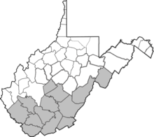
grey: counties of West Virginia that were still held by the Confederates in February 1863
Search within the encyclopedia