Ruhr (river) — geography, history and industrial legacy
The Ruhr is a 218 km river in western Germany that rises in the Sauerland and joins the Rhine near Düsseldorf. It shaped a major industrial region; today it combines reservoirs, nature and cultural reuse.
Overview
The Ruhr is a prominent river in western Germany, about 218 kilometres long. It rises near the town of Winterberg in the upland Sauerland and flows generally westward before joining the Rhine near Düsseldorf. The river and its valley have long provided water resources, transport corridors and sites for settlement and economic activity within the state of North Rhine-Westphalia.
Image gallery
4 Images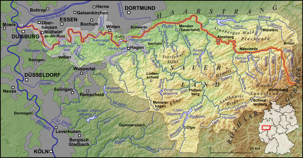


Course and towns
From its headwaters the Ruhr cuts through a mix of forested upland and open valleys. Along its course the river passes or lies close to a number of towns and urban districts. Notable places on or near the river include Arnsberg, Iserlohn, Schwerte, Bochum and Essen. Many other cities in the wider Ruhr valley form a continuous metropolitan area often referred to as the Ruhrgebiet, one of Germany’s most densely populated regions.
Hydrology, reservoirs and uses
The river is regulated by a system of dams, reservoirs and weirs that moderate seasonal flow, provide drinking water, and support recreation. Several popular lakes along the Ruhr, such as Baldeneysee in Essen and Hengsteysee near Hagen, were created by damming the river and are used for boating, angling and riverside leisure. The river corridor also accommodates roads, rail lines and local canals that tie towns to the wider Rhine and national transport networks.
Historical development and industrialisation
During the Middle Ages some towns of the Ruhr valley entered wider trade networks, and the region gradually developed commercial ties and local craftsmanship. From the mid-14th century onwards, deposits of coal were increasingly exploited along the valley. The availability of fuel together with transport links made the Ruhr a focal point for industry, and the valley later became synonymous with extensive coal and steel production. The economic importance of extraction and heavy manufacturing transformed towns into industrial centres and underpinned large-scale urban growth.
Business, decline and cultural reuse
The accumulation of factories and mines stimulated regional business and created a dense industrial landscape. By the 19th and early 20th centuries the Ruhr was one of Europe’s primary heavy-industry regions. From the mid-20th century onward the traditional coal and steel sectors contracted under economic, technological and environmental pressures. Many former industrial complexes were closed or dismantled; several have been converted into museums, parks and venues for cultural events and entertainment, becoming symbols of regional renewal.
Significance and conservation
- Natural and built heritage: the Ruhr combines upland nature near its source with historically industrial urban zones downstream; both aspects contribute to local identity.
- Water management: reservoirs and a regional water authority help supply drinking water, control floods and maintain ecological quality along the river.
- Adaptive reuse: former mines and factories now host cultural institutions, technical museums and public parks that attract visitors and preserve industrial heritage.
Today the Ruhr remains important for regional planning, environmental management and recreation. Its valley illustrates the long interaction between natural resources and human activity: a source of water, a driver of industrial development and now a corridor for nature conservation and cultural regeneration within one of Germany’s most populous areas.
Related articles
Author
AlegsaOnline.com Ruhr (river) — geography, history and industrial legacy Leandro Alegsa
URL: https://en.alegsaonline.com/art/84673
Sources
- uaruhr.org : "Full Story"