Bochum
![]()
This article is about the city of Bochum, for Herbert Grönemeyer's album of the same name see 4630 Bochum, for the former town of Bochum in South Africa see Senwabarwana.
The city of Bochum [ˈboːxʊm] (Westphalian: Baukem from Old Saxon Boc-hem ['bo:khe:m]) is a major city in the centre of the Ruhr region. The name of the city originated from earlier Low German names such as Bukhem or Bokheim, where boc is the Low German word for beech and hum or hem in turn stands for -heim. Accordingly, the name denoted a place of residence under beech trees and could today also be translated as "Buchenheim" (cf. also Bocholt).
The independent city in the administrative district of Arnsberg is, along with Duisburg, Essen, Dortmund and Hagen, one of the five major centres of the Ruhr area and belongs to the Rhine-Ruhr metropolitan region. With approximately 370,000 inhabitants, Bochum is the sixth largest city in North Rhine-Westphalia, the second largest city in Westphalia and one of the 20 largest cities in Germany. Bochum is a member of the Landschaftsverband Westfalen-Lippe and the Regionalverband Ruhr. The population of the city exceeded the 100,000 mark with the incorporations in 1904, making Bochum a major city. With the incorporation of the until then district-free town of Wattenscheid (about 72,000 inhabitants), the city grew significantly in 1975.
Bochum is home to nine universities or branches of universities. Since the founding of the Ruhr University in 1962 in the southern district of Querenburg, the first new university founded in the Federal Republic of Germany after the Second World War and with over 40,000 students one of the largest universities in Germany, Bochum has been a university city. The German Mining Museum, the Schauspielhaus (theatre), the Zeiss Planetarium Bochum, the Railway Museum, the Bermuda3eck, the Ruhr Stadium as the venue of the VfL Bochum, the Zoo and the Fossilium as well as the world's longest-running musical at the same location, Starlight Express, are also known beyond the region. The cityscape is characterised, among other things, by a church steeple and skyscraper skyline as well as various architectural monuments, especially of historicism, expressionism and post-war modernism. The city's industrial monuments are linked together on the Route of Industrial Culture "in the heart of the coalfield".
There are also various mining institutions in Bochum. The Bochumer Verein, founded in 1842, wrote industrial history when the company succeeded in casting steel in moulds at the end of the 1840s. The company's most famous product was bells made of this material. The 15,000 kg bell from the 1867 World's Fair in front of Bochum's town hall is a reminder of this era. After the end of mining, Bochum developed primarily into a technology and service location.
Geography
Geographical position
Bochum is situated on the flat hilly "Bochumer Landrücken" as part of the Ruhr heights between the rivers Ruhr and Emscher at the border between the southern and northern Ruhr coal zone. The highest point in the city area is at Kemnader Straße in Stiepel at an altitude of 196 m above sea level, the lowest point at 43 m above sea level is at Blumenkamp in Hordel.
Flat-hilly land ridge means that the terrain in Bochum is characterised by even gradients and slopes that rarely exceed 3 %. Individual steeper terrains can be found, for example, on Harpener Hellweg near the Berghofer Holz nature reserve (3.4 %), on Westenfelder Str. in the Wattenscheid district (3.47 %) or on Kemnader Str., which leads from the banks of the Ruhr in Stiepel (71 m above sea level) up to the centre of Stiepel (196 m above sea level; 5.1 % gradient). Stretches of road leading from the lower-lying Ruhr valley through the towns belonging to the south of Bochum also have a steeper gradient (e.g. Kassenberger Str. and Dr.-C.-Otto-Str. in Dahlhausen, Blankensteiner Str. in Sundern).
The largest extension of the city area in the north-south direction is 13.0 and in the west-east direction 17.1 km. The length of the city boundary is 67.2 km.
Geology
In the southern part of the city, sedimentary rocks of the seam-bearing Upper Carboniferous are present. These are overlain in the north by marine deposits of the Upper Cretaceous. The inland ice of the Saale Ice Age left a ground moraine, erratic blocks and meltwater deposits. Loess was deposited during the Weichselian cold period. The geological strata can be visited in the former quarry of the Klosterbusch colliery and in the Bochum Geological Garden.
Waters
The waters in Bochum drain to the north into the Emscher, to the south into the Ruhr, which is dammed in the southeast of Bochum to the Kemnader Lake. To the east the Oelbach which flows through the Ümminger See and flows into the Ruhr.
see also: List of water bodies in Bochum
Vegetation
Bochum has some forests in the south, including the Weitmarer Holz. As a rule, it is a mixed oak-beech forest. The occurrence of holly indicates the temperate climate. Bochum has several designated nature reserves and landscape conservation areas.
See also: List of protected landscape areas in Bochum and List of nature reserves in Bochum
Neighboring communities
| Gelsenkirchen (district-free) | Herne (independent) | Castrop-Rauxel (Recklinghausen district) |
| Essen (district free) |
| Dortmund (independent) |
| Hattingen (Ennepe-Ruhr district) | Witten (Ennepe-Ruhr district) |
City breakdown
→ Main article: City division of Bochum
The urban area of Bochum consists of six city districts; each has a district council, whose chairman is the district mayor. The boroughs are divided into districts.
| Borough | Districts |
| Bochum-Centre (I) | Bochum city centre, Altenbochum, Grumme, Hamme, Hofstede, Hordel, Riemke |
| Bochum-Wattenscheid (II) | Eppendorf, Günnigfeld, Höntrop, Leithe, Munscheid, Sevinghausen, Wattenscheid-Mitte, Westenfeld |
| Bochum North (III) | Bergen, Gerthe, Harpen, Hiltrop, Kornharpen, Voede branch |
| Bochum East (IV) | Laer, Langendreer, Werne |
| Bochum South (V) | Querenburg, Stiepel, Wiemelhausen |
| Bochum Southwest (VI) | Dahlhausen, Linden, Sundern, Weitmar (Bärendorf, Mark and Mitte) |
Climate
The average temperature in Bochum is 10.1 °C on an annual average. The coldest month is January with 2.5 °C, the warmest is July with 18.4 °C. The amount of precipitation is about 750 millimeters per year, with the most precipitation falling in August with 85 millimeters.
| Bochum | ||||||||||||||||||||||||||||||||||||||||||||||||
| Climate diagram | ||||||||||||||||||||||||||||||||||||||||||||||||
| ||||||||||||||||||||||||||||||||||||||||||||||||
| Monthly average temperatures and precipitation for Bochum
Source: DWD, data: 2015-2020 | ||||||||||||||||||||||||||||||||||||||||||||||||||||||||||||||||||||||||||||||||||||||||||||||||||||||||||||||||||||||||||||||||||||||||||||||||||||||||||||||||||||||||||||||||||||||||||||||||||||||||||||||||||||||||||||||||||||||||||||||||||||||||||||
Low emission zone
The Low Emission Zone in Bochum was established on 1 October 2008 and modified on 1 January 2012. It currently covers 3⁄4 of all households in the city.

Aerial view of the Ruhr-Universität
_01_ies.jpg)
Part of the Bochum skyline with Exzenterhaus, Stadtwerke-Haus, Park-Inn-Hotelhochhaus and Europahaus
_03_ies.jpg)
View of the centre of Bochum from the Bismarck Tower in the city park
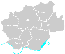
The six districts of Bochum
History
→ Main article: History of the city of Bochum
Archaeological finds testify to a sedentary settlement of the present-day Bochum urban area in the late Neolithic period in the area of the Oelbach.
The first documented mention is found in 890 in the Heberegister of Werden Abbey. However, it is assumed that Charlemagne had an imperial court built at the intersection of two trade routes south of today's Provost Church as early as around 800. In 1041 the place was mentioned in a document of the archbishops of Cologne under the name "Cofbuokheim". In 1321, Count Engelbert II of the Mark Bochum confirmed existing powers of the Schultheißen in a document. This is often mentioned as the granting of town rights. The von Berswordt family, which existed in several lines from 1400 until today, is resident in Weitmar with the branch line von Berswordt-Wallrabe. Bochum remained an agrarian town until the 19th century (despite the fact that coal mining was already documented in the 14th century and in 1502) with some supra-local authorities, to which a mining office was added in 1738. Bochum was also an inland Hanseatic town.
Until 1806 the town belonged to the Prussian County of Mark, then until 1813 to the Ruhr Department of the Grand Duchy of Berg, then temporarily to the Prussian Civil Governorate between the Weser and the Rhine. In 1815 the city became part of Prussia and was assigned to the province of Westphalia. In 1817, the city of Bochum became the seat of the district of Bochum, from which, however, it left in 1876 to become a district-free city. The district of Bochum existed until 1929 and was then dissolved.
Bochum's rise to become a mining town began in 1841, when the first shaft of the President mine was sunk behind the city limits of the still independent Hamme. This was the first deep mine in the Westphalian part of the Ruhr area, whereby the marl cover was penetrated. In the 1850s and 1860s the foundation of deep mines followed, which at the end of the 19th century shaped the economic structure alongside the steel industry. Technical difficulties in building the mines and the resulting financial bottlenecks meant that the mines were slow to develop. Furthermore, the economic crisis after the foundation of the German Reich caused the sales markets for coal to collapse for a time. The decisive rise and further expansion of the collieries followed in the 1880s. All the collieries now had a railway connection. The coal refined as coke was needed for steel production; this led to the construction of coking plants on the colliery sites.
In 1843 Jacob Mayer acquired a site on the Essener Chaussee, on which a factory was built for the production of cast steel. In 1854, after the financial participation of Cologne merchants, the company was renamed Bochumer Verein für Bergbau und Gußstahlfabrikation. Under the technical director Louis Baare, the Bochumer Verein developed into one of the leading companies in the Ruhr area.
In 1843 Max Greve was elected mayor, who significantly supported the development of Bochum into an industrial city. During his term of office, the gasworks (1855), the waterworks (1871) and the chamber of commerce (1856) were founded. The economic rise of the mines and the steel industry led to a high demand for labour, which could not be met by the population at the time. The population of Bochum grew from 4282 to 25174 inhabitants between 1843 and 1873. In order to recruit workers, housing was created near the factories, away from the traditional residential areas. The factory housing of the Bochumer Verein was located in the Griesenbruch, separated from the Bochum city area by the cast steel railway.
In 1860, Bochum was connected to the Witten/Dortmund-Oberhausen/Duisburg railway line of the Bergisch-Märkische Eisenbahn-Gesellschaft, followed in 1874 by the Osterath-Dortmund Süd railway line of the Rheinische Eisenbahn-Gesellschaft, both of which were nationalised from 1880.
The growth of Bochum at the end of the 19th century took place without any overriding planning, and thus no orderly infrastructure could develop for the time being. Industrial settlements and factory housing were built at the colliery sites, while the established farms around the industrial sites continued to farm. The strongest population growth was in the northern and eastern suburbs (Langendreer, Werne, Riemke, Hofstede).
The first tramway line was put into operation in 1894, connecting Bochum and Herne. Since 1896, the line has been operated by the Bochum-Gelsenkirchener Straßenbahnen AG (BoGeStra).
By the end of the 19th century, the development of neighbouring suburbs had extended to the Bochum city area, and dependencies developed in terms of infrastructure such as gas and water supply. This led to the first wave of incorporations, in which Hamme, Hofstede, Grumme and Wiemelhausen were added to the city of Bochum. In 1905 the population of the city exceeded 100,000 - Bochum was a large city. Bochum's inner city had a very heterogeneous structure, which was still strongly influenced by its time as a small town. A uniform design of the inner city and a planned development of the Ehrenfeld district took place until the outbreak of the First World War.
The consequences of the war - unemployment, strikes, the French occupation, devaluation of money - interrupted further growth. An economic upswing followed in the years 1925 to 1929, during which time further suburbs were added to the Bochum city area (including Riemke, Langendreer, Stiepel, Querenburg). The city area now extended to the northern Ruhr valley. However, Bochum's request to create an access to the economically important Rhine-Herne Canal on the city territory was not granted.
On November 9, 1938, in the so-called Reichspogromnacht, riots against the Jewish fellow citizens also took place in Bochum; the synagogue was set on fire. The first Jewish citizens were deported to concentration camps and numerous Jewish institutions and homes were destroyed. About 500 Jewish citizens are known by name who perished in the Shoa in the following years, including 19 who were younger than 16. In December 1938, the Jewish elementary school teacher Else Hirsch began organizing a total of ten Kindertransports to the Netherlands and Great Britain to rescue Jewish children and young people. Many Bochum children from other persecuted groups were also taken in by Dutch families and thus saved from deportation and murder.
More than 30,000 people were used as forced labourers in Bochum and Wattenscheid during the Second World War.
During the Second World War, 38 percent of the town was destroyed by bombing (homeless people were partially evacuated to Rügenwalde/ Hinterpommern in 1944). From June 20, 1940 to March 22, 1945, a total of about 11,595 tons of bombs were dropped in 46 different bombings, mainly by the Royal Air Force. An important target among others was the Bochumer Verein as the third largest company of the Vereinigte Stahlwerke AG. Even today, aerial bombs are still found as bomb duds and have to be defused by the explosive ordnance disposal service.
On April 10, 1945, the US Army finally occupied Bochum. Elsewhere in Germany, the war continued until early May. The Second World War finally ended on 8 May with the unconditional surrender of the Wehrmacht.
After the end of the Second World War, Bochum belonged to the British occupation zone. The British military administration set up two DP camps in Bochum to house so-called displaced persons. The majority of them were former forced labourers from Poland.
In the post-war period, Bochum developed into a cultural centre of the Ruhr area. In 1962, Adam Opel AG, a subsidiary of General Motors, opened the three Opel plants (Plant I, Plants II/III) in the districts of Laer and Langendreer, among others on the former site of the Dannenbaum colliery, which became a symbol of structural change in the Ruhr region.
In 1964, the Ruhr-Park was completed in the Harpen district, the second shopping centre "on a greenfield site" in the Federal Republic, today the largest of its kind in Germany. In 1973, the last coal mine in Bochum (Hanover Colliery) closed. In addition to extensive industrial zones, large green areas were created, some of them almost rural in appearance, reaching as far as the Ruhr and the Kemnader reservoir (released in 1980), among others. In 1979 the first city railway line and the Ruhr stadium were opened.
Bochum has been a theatre city since 1919 and a university city since 1965 (Ruhr University with over 40,000 students), and a musical city since 1988. On 12 June 1988, the German-language musical production Starlight Express by Andrew Lloyd Webber opened at the Stadionring.
In 1989, the U 35 light rail line from Bochum main station to Herne-Schloss Strünkede went into service. In 1993 the cities of Bochum, Hattingen, Herne and Witten joined together to form the Middle Ruhr Region. In 2003 the RuhrCongress event centre was inaugurated. In 2005 the foundation stone was laid for the new synagogue of the Jewish community of Bochum-Herne-Hattingen.
In the year 2000, the daytime rupture of the Höntrop Loch was the dominant topic of the national media for weeks, as a result of which several residential buildings were literally on the brink of collapse overnight.
The Bochum site had been struggling since the financial crisis in 2008 with the closure of the Nokia plant and the already looming closure of Opel vehicle production, which was finally completed at the end of 2014. The loss of vehicle production alone cost around 3000 employees their jobs.
Incorporations
- On 1 April 1904 the first incorporations took place: Grumme, Hamme, Hofstede and Wiemelhausen.
- On 1 April 1926 there was a second wave of incorporation: Altenbochum, Bergen, Hordel, Riemke, Weitmar and parts of Eppendorf and Westenfeld were incorporated. The communities of Munscheid, Eppendorf, Günnigfeld, Höntrop, Westfälisch Leithe, Sevinghausen and Westenfeld as well as a small part of Königssteele were incorporated into the neighbouring town of Wattenscheid.
- On 1 August 1929 the third large incorporation took place with Gerthe, Harpen, Hiltrop, Laer, Langendreer, Linden-Dahlhausen, Querenburg, Stiepel and Werne.
- On January 1, 1975, the city was united with the city of Wattenscheid, which had been a district-free city since April 1926, to form the new city of Bochum, which still exists today.
Population development
→ Main article: Population development of Bochum
In 1904, the population of the city of Bochum exceeded 100,000, making it a major city. By 1926, this number had doubled to 200,000. On 1 January 1975, the population reached its historic high of 417,336 due to the incorporation of the town of Wattenscheid (81,469 inhabitants, 1974). On 31 December 2015, the "Official Population" for Bochum was 364,742 according to the update of the State Office for Information and Technology of North Rhine-Westphalia in the NRW state database (only main residences and after comparison with the other state offices), by 2030 it will decline to 337,620 according to the forecast of the State Office.
The unemployment rate in Bochum was 8.9 percent as of June 30, 2018, which is higher than the statewide average in North Rhine-Westphalia (6.7 percent in June 2018).
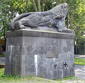
The Lion Monument Bochum
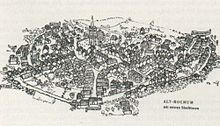
Bochum 1790
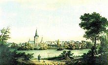
Bochum around 1830
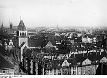
View over Bochum 1939
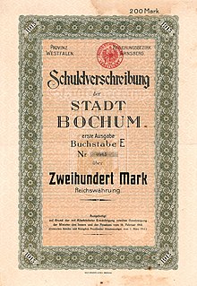
Bond for 200 marks of the city of Bochum dated April 1, 1913
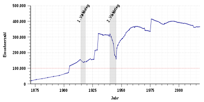
Population development of Bochum from 1871 to 2017 .
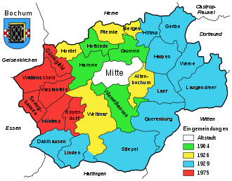
The phases of incorporation into the Bochum urban area
_2010-08-12_050.jpg)
Bochum 2010
Search within the encyclopedia
.svg.png)