Germany — the Federal Republic of Germany
Comprehensive overview of Germany: geography, history, government, economy and cultural significance in Europe and the world.
Overview
Germany, officially the Federal Republic of Germany, is a nation in Central Europe. Its conventional short name in German is Deutschland. The country's approximate central coordinates are given as 51°N, 9°E. Germany is the most populous country wholly in Europe, with about 83 million residents, and it plays a leading role in continental politics, trade, and culture. Berlin is the capital and largest city.
Image gallery
10 Images


Geography and neighbours
Germany occupies a temperate zone with coastlines on the North Sea and the Baltic Sea. Its landscape ranges from lowlands in the north to upland regions and the Alps along the southern border. It shares land frontiers with nine countries; major neighbours include:
- Denmark to the north
- Poland and the Czech Republic to the east
- Austria and Switzerland to the south
- France, Luxembourg, Belgium and the Netherlands to the west
Historical development
The lands now called Germany were known in antiquity as Germania. Over many centuries they were part of the Holy Roman Empire (roughly A.D. 900–1806). Modern German unity emerged in the 19th century and the state underwent dramatic political change in the 20th century, including two world wars and the subsequent division into the Federal Republic of Germany in the west and the German Democratic Republic in the east. From 1949 until 1990 the country existed as two states; the city of Berlin was split and separated by the Berlin Wall for much of that period. Reunification in 1990 restored a single federal republic, sometimes abbreviated FRG or BRD.
Government, economy and international role
Germany is a federal parliamentary republic with sixteen constituent states. It combines a strong industrial base and export-oriented economy with a social welfare system. As one of the largest economies in Europe, Germany is influential in international institutions; the former West German state was among the founding partners leading to today’s European Union. The country has been a major destination for migrants, ranking after the United States in some measures of migration inflows, and has attracted people worldwide for work and refuge (migration statistics and trends).
Culture and notable facts
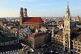
Germany has a rich cultural heritage in philosophy, music, literature, science and engineering. Cities such as Berlin, Munich, Hamburg and Frankfurt are centers of culture and commerce. While the nation speaks German, regional dialects and diverse local traditions persist. In population comparisons within Europe, Germany is the largest country excluding Russia. The modern state maintains extensive international ties and continues to shape regional affairs.
Quick facts
- Official name: Federal Republic of Germany.
- Capital: Berlin.
- Coastlines: North Sea and Baltic Sea.
- Historic notes: former division into West Germany and East Germany; roots in the Holy Roman Empire.
For further regional, historical and statistical details consult targeted resources and national institutions linked above.
Geography
→ Main article: Geography of Germany
Physical geography
The major natural regions are from north to south: the North German Lowlands, the Central Uplands and the Alpine Foothills with the Alps.
Geology
→ Main article: Geology of Germany
Geologically, Germany belongs to Western Europe, i.e. to that part of the continent that was successively annexed to the Precambrian consolidated "Ur-Europa" (Eastern Europe including a large part of Scandinavia, cf. Baltica) only in the course of the Phanerozoic by continent-continent collisions (mountain formations). The corresponding crustal provinces (bedrock provinces) are classically simplified as (Eastern) Avalonia (cf. Caledonian mountain building) and Armorica (cf. Variscan mountain building). The youngest crustal province is the Alpine-Carpathian orogen (cf. Alpine mountain building), in which Germany has a share only with the extreme south of Bavaria and which, in contrast to the other two tectonic provinces, represents an active orogen.
The present-day surface geology of Germany, i.e. the pattern of rock complexes of different ages and compositions, as often depicted in geological maps, only emerged in the course of the last 30 to 20 million years in the younger Cenozoic era and was decisively shaped by two events: the Alpidic mountain building and the Quaternary Ice Age.
The Quaternary Ice Age shaped the comparatively monotonous surface geology of northern Germany and the Alpine foothills with its moraine deposits and other accompanying phenomena of large-scale glaciations (cf. glacial series).
The surface geology of central and most of southern Germany is the result of significant rupture-tectonic uplift and subsidence, which can be traced back to the long-distance effect of the Alpidic mountain building. In this process, partly old (predominantly Palaeozoic), Variscan-folded bedrock complexes (slate mountains and crystalline) were uplifted from the subsoil and exposed over large areas (e.g. the Rhenish Slate Mountains, the Rhenish Crystalline Mountains). Rhenish Slate Mountains, Harz Mountains, Ore Mountains), in part the earth's crust sank and formed sedimentation areas that accommodated more or less thick Cenozoic sedimentary sequences (Upper Rhine Graben, Lower Rhine Graben, Hessian Depression, Molasse Basin). The tablelands with their unfolded Mesozoic stratigraphic sequences, dominated by Triassic and Jurassic (Thuringian Basin, South German stratigraphic country), occupy an intermediate tectonic position.
Relief
The geologically young folded mountain range of the Alps is the only high mountain range in which Germany has a share. The German Alps, which are almost entirely located in the federal state of Bavaria - a small part of the far northwest of the Allgäu Alps is in Baden-Württemberg - have the only mountain peaks above 2000 m a.s.l.. The summit of the Zugspitze (2962 m a.s.l.), which Germany shares with Austria, is the highest point in the country.
The German low mountain ranges extend from the northern edge of the low mountain threshold to the edge of the Alps and the Upper Rhine with Lake Constance. They tend to increase in height and extent from north to south. The highest low mountain peak is the Feldberg in the Black Forest (1493 m above sea level), followed by the Großer Arber in the Bavarian Forest (1456 m above sea level). The Erzgebirge, the Fichtelgebirge, the Swabian Alb and the Harz, which rises quite isolated as the northernmost of the highest German low mountain ranges with the Brocken at 1141 m above sea level, also have peaks above 1000 m above sea level. North of the low mountain range threshold, only a few mountains within the glacial terminal moraine ranges reach more than 100 m above sea level, the highest of which is the Heidehöhe in Schraden (Südlicher Landrücken in the Brandenburg-Saxony border region) at 201 m above sea level.
The deepest generally accessible land site in Germany is at 3.54 m below sea level in a depression near Neuendorf-Sachsenbande in the Wilstermarsch (Schleswig-Holstein). The deepest cryptodepression is also located in this federal state: at 39.6 m below sea level, it lies at the bottom of Lake Hemmelsdorf northeast of Lübeck. The deepest artificially created ground point is 267 m below sea level at the bottom of the Hambach open-cast mine east of Jülich in North Rhine-Westphalia.
See also: List of the highest mountains in Germany and List of mountains and mountain ranges in Germany
Climate
→ Main article: Climate in Germany
Germany belongs entirely to the temperate climate zone of Central Europe in the area of the west wind zone and is located in the transitional area between the maritime climate in Western Europe and the continental climate in Eastern Europe. The climate in Germany is influenced, among other things, by the Gulf Stream, which makes the average temperature level unusually high for the latitude.
The average annual temperature, based on the normal period 1961-1990, is 8.2 °C in the national area average, the average monthly temperatures range from -0.5 °C in January to 16.9 °C in July. The mean annual precipitation is 789 millimetres. The mean monthly precipitation ranges from 49 millimetres in February to 85 millimetres in June.
The lowest officially recognised temperature measured in Germany was -37.8 °C; it was recorded in Wolnzach in 1929. The highest temperature so far was 41.2 °C and was measured on 25 July 2019 in Duisburg-Baerl and in Tönisvorst on the Lower Rhine.
See also: Time series of air temperature in Germany and List of temperature records in Germany
Waters
Of the six rivers with the largest catchment areas, the Rhine, Elbe, Weser and Ems drain via the North Sea and the Oder via the Baltic Sea into the Atlantic, while the Danube flows into the Black Sea and thus hydrographically belongs to the Mediterranean. The catchment areas of these two systems are separated from each other by the main European watershed.
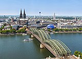
The Rhine, which originates in Switzerland, dominates the southwest and west. For 865 kilometres, it flows through or along the border with Germany before flowing into the North Sea via the Netherlands. Its most important German tributaries are the Neckar, Main, Moselle and Ruhr. The Rhine is of great economic importance and is one of the busiest waterways in Europe. The Danube drains almost the entire German Alpine foothills in the south for 647 kilometres and flows on to Austria and south-eastern Europe. Its most important German tributaries are the Iller, Lech, Isar and Inn. The Elbe, which rises in the Czech Republic, flows through eastern Germany for 725 kilometres. Its most important German tributaries are the Saale and Havel. For 179 kilometres, the Oder, as well as its most important tributary, the Neisse, is the border river to Poland. Only the catchment area of the 452-kilometre-long Weser lies entirely in Germany. It is fed by the Werra and Fulda rivers and drains the central north. The Ems flows for 371 kilometres through the extreme northwest of the country. Its catchment area also extends to parts of the Netherlands.
The natural lakes are predominantly of glacial origin. Therefore, most of the large lakes are found in the Alpine foothills, in Holstein Switzerland and in Mecklenburg. The largest lake belonging entirely to German territory is the Müritz, which is part of the Mecklenburg lake district. The largest lake with a German share is Lake Constance, which is also bordered by Austria and Switzerland. In western and eastern Germany there are many artificial lakes created by the recultivation of open-cast lignite mines or industrial wastelands, such as the Leipziger Neuseenland or the Dortmund Phoenix Lake.
See also: List of lakes in Germany and List of rivers in Germany
Islands
The Frisian Islands are located in the Wadden Sea, directly off the Dutch, German and Danish coasts of the North Sea. While the North Frisian Islands are mainland remnants separated from the coast by land subsidence and subsequent flooding, the East Frisian Islands are barrier islands formed from sediments washed up by currents parallel to the coast as well as wave and tidal dynamics. Heligoland, located in the middle of the German Bight, is the furthest inhabited German island from the mainland. It dates back to the rise of a salt dome in the subsoil of the North Sea.
The largest German islands in the Baltic Sea are (from west to east) Fehmarn, Poel, Hiddensee, Rügen and Usedom. Rügen is also the largest German island. The largest peninsula is Fischland-Darß-Zingst. With the exception of Fehmarn, these land areas are part of a Bodden coast, i.e. a ground moraine landscape flooded after the ice age and subsequently modified by landfall processes.
The largest and best-known islands in inland waters are Reichenau, Mainau and Lindau in Lake Constance and Herreninsel in Lake Chiemsee.
See also: List of German islands and List of German inland islands
Flora
The natural area of Germany lies in the temperate climate zone; from west to east, its natural vegetation marks the transition from a westerly lake climate to a continental climate. Without human influence, the flora would be mainly characterised by deciduous and mixed forests, with the exception of nutrient-poor or dry sites such as rocky outcrops, heathland lowlands and moorland, as well as the alpine and subalpine highlands, which are extremely poor in vegetation and cold temperate in their climate.
Locally, the flora in Germany shows a high degree of diversification due to site factors of the terrain and the mesoclimatic situation. The total stock of plant species living in the wild in Germany is estimated at over 9,500 species, of which almost 3,000 are seed plants, 74 fern plants, over 1,000 mosses and about 3,000 diatoms. In addition, there are about 14,000 species of fungi and 373 species of slime moulds. Particularly on fallow and disturbed areas, a number of introduced species can now be found, such as the black locust and the glandular touch-me-not.
Currently, forests cover 32 percent of the land area in Germany. This makes Germany one of the most densely forested countries in the European Union. The current tree species composition corresponds only to a small extent to natural conditions and is mainly determined by forestry. The most common tree species are the common spruce with 26.0 percent of the area, followed by the Scots pine with 22.9 percent, the copper beech with 15.8 percent and the oaks with 10.6 percent.
Around half of the state's land area is used for agriculture; according to the Federal Statistical Office, this amounted to 182,637 square kilometres on 31 December 2016. In addition to use as permanent grassland, arable farming has been practised on a large part of it, since the Stone Age or the Bronze Age predominantly with crops that do not occur naturally in Central Europe (most of the cereals from the Near East, potatoes and maize from America). In the river valleys, including those of the Main, Moselle, Ahr and Rhine, the landscape was often transformed for viticulture.
The preservation of nature is a public task in Germany and a state objective enshrined in Article 20a of the Basic Law. Nature conservation is served by 16 national parks (see National Parks in Germany), 19 biosphere reserves, 105 nature parks and thousands of nature reserves, landscape conservation areas and natural monuments.
Fauna
About 48,000 animal species have been recorded in Germany, including 104 mammal, 328 bird, 13 reptile, 22 amphibian and 197 fish species, as well as over 33,000 insect species, making the country "one of the more species-poor areas due to its geological history and geographical location". In addition to these species, there are over 1,000 crustaceans, almost 3,800 spiders, 635 molluscs and over 5,300 other invertebrates.
Wild mammals native to Germany include roe deer, wild boar, red and fallow deer, as well as foxes, martens and lynx. Beavers and otters are rare inhabitants of the floodplains, with some populations on the rise again. Alpine ibex, alpine marmot and chamois live in the Bavarian Alps; the latter can also be found in various low mountain ranges. Other large mammals that lived on the territory of present-day Germany in earlier times have been wiped out: Wild horse, aurochs (15th century), bison (16th century), brown bear (19th century), wolf (19th century), elk (20th century). While moose now occasionally migrate from neighbouring countries, wolves have re-established themselves firmly in Germany, coming from Poland, and gave birth to offspring for the first time around the turn of the millennium. In 2018, there were 73 documented wolf packs in Germany, most of which live in the states of Saxony, Brandenburg and Lower Saxony. In 2013, a herd of bison was released in the Rothaargebirge. In October 2019, a brown bear presumably migrating from Italy was photographed by a wildlife camera in the district of Garmisch-Partenkirchen. In the following months, the animal was detected again several times. In 2006, Bruno, the "problem bear", had already migrated to Germany. In the meantime, lynx, which were originally native to Germany, are living in Germany again, albeit in low population densities, because they are repeatedly the victims of poaching and road traffic.
The white-tailed eagle, which is considered the model for the German heraldic animal, is again found in about 500 pairs, mainly in Mecklenburg-Western Pomerania and Brandenburg. The golden eagle is now only found in the Bavarian Alps, where the bearded vulture from Switzerland and Austria, which had been eradicated there, is also making a comeback. The most common birds of prey today are the buzzard and the kestrel; the population of peregrine falcons is much smaller. More than half of the total population of red kites breeds in Germany, but is declining due to intensive agriculture. In contrast, many birds benefit from the presence of humans as cultural successors, especially urban pigeons, blackbirds (formerly forest birds), sparrows and titmice, whose survival is also ensured by winter feeding, as well as crows and gulls on rubbish tips. The Wadden Sea is a resting place for ten to twelve million migratory birds per year.
The salmon, which used to be common in the rivers, was largely wiped out in the course of industrialisation, but was reintroduced to the Rhine in the 1980s. In Germany, the last sturgeon was caught in 1969. Carp, introduced by the Romans, are kept in many ponds. The species of seal and grey seal - the latter the largest predator native to Germany - which were almost wiped out by professional fishermen in the mid-20th century as competitors for prey and are now protected, are now once again represented by a few thousand specimens on the German coasts. Eight species of cetaceans are found in the North Sea and Baltic Sea, including the harbour porpoise, and one species of dolphin, the common dolphin.
Reptiles living in Germany include grass snakes, adder and European pond turtle. Amphibians such as salamanders, frogs, toads, toads and newts are all on the Red List of threatened species in Germany.
The - partly invasive - neozoa in Germany include raccoon, raccoon dog, muskrat, nutria, collared parakeet, Canada goose and Egyptian goose.
Hunting
→ Main article: Hunting in Germany
In Germany, hunting is a subjective right connected to land ownership and is organised in a district hunting system. The most important game species in terms of the value of game and the damage caused by game in the forest and fields are roe deer and wild boar. Other game species relevant for hunting include red deer, mallard and brown hare. In Germany, there were almost 360,000 hunters in 2016/17. In 2019/2020, over 1.2 million roe deer were shot, and in 2019 just under 600,000 wild boar.
Human geography
Germany has a total of nine neighbouring countries: Germany borders Denmark to the north, Poland to the north-east, the Czech Republic to the east, Austria to the south-east, Switzerland to the south, France to the south-west, Luxembourg and Belgium to the west and the Netherlands to the north-west. The total border length is 3876 kilometres. This makes Germany the European country with the most neighbouring states.
In Germany, a total of 51 percent of the land area is used for agriculture (2016), forests cover another 30 percent. 14 percent is used as settlement and transport land. Water areas account for two per cent, and the remaining three per cent are distributed among other areas, mostly wasteland and also open-cast mines.
Administrative structure
The federally structured Federal Republic of Germany consists of 16 member states, officially known as Länder (federal states). The city states of Berlin and Hamburg each consist of unitary municipalities of the same name, while the Free Hanseatic City of Bremen, as the third city state, comprises two separate municipalities, Bremen and Bremerhaven. In contrast to other federal states, there are no federally independent territories in Germany.
The municipalities are the smallest democratically constituted, legally independent regional authorities and administrative units in Germany. They have a long tradition due to their cooperative character, which goes back to the Middle Ages. Today, with the exception of the city states and most independent cities, the municipalities in Germany are grouped into districts and other associations of municipalities. There are 401 territorial authorities at district level, of which 294 are districts and 107 are independent cities. They are subdivided into a total of 10,790 municipalities (as of January 2021), with a downward trend, as well as more than 200 largely uninhabited municipality-free areas. Districts and municipalities are subject to the municipal constitutional law of the respective federal state and are therefore organised differently throughout Germany. The district is thus both a supra-local local authority and a lower state administrative authority, it has its own representative body, the district council (Article 28 (1) sentence 2 GG), and performs various tasks of the "supra-local community" for the municipalities belonging to the district.
In terms of constitutional law, the municipalities are part of the Länder, which means that they are subject to their right of supervision and instruction and therefore have no sovereign power of their own. The guarantee of self-government in Article 28 (2) of the Basic Law - on the one hand a so-called institutional legal subject guarantee, from which it follows that there must be municipalities in the state structure at all, and on the other hand a subjective public right with constitutional rank - distinguishes between cities and municipalities, which are granted this right in its entirety, and municipal associations (counties), which are only granted it in a graded form. Thus, for the delimitation of tasks between municipalities and districts, there is a clear rule-exception relationship in favour of the municipalities (principle of subsidiarity). With regard to the "affairs of the local community", i.e. the power guaranteed in Article 28 (2) sentence 1 of the Basic Law to conduct business independently in this area of responsibility (so-called objective legal institution guarantee), the Federal Constitutional Court has established the primacy of the municipal level over the district level in accordance with the law: According to this, the principle of the "universality of the municipal sphere of action" applies to cities and municipalities "as an essential and identity-determining feature of municipal self-government", in contrast to the special competence of municipal associations by virtue of explicit legal allocation, with which there are also no fixed municipal association sovereignties.
See also: Local self-government (Germany)
|
Metropolitan areas
In Germany, densely populated areas and conurbations (agglomerations) are not precisely defined statistically. There are 81 large cities (100,000 inhabitants or more), 14 of which have more than 500,000 inhabitants, historically predominantly in the west and southwest of Germany. These agglomerations, which run along the Rhine, form the central part of the central European population concentration (blue banana). Most agglomerations are monocentric, whereas the Ruhr area is a (polycentric) conurbation. With its numerous centres, Germany does not have a primary city, unlike neighbouring countries such as Austria with its capital Vienna and Denmark with Copenhagen.
On the territory of Germany, eleven European metropolitan regions have been defined by the Conference of Ministers for Spatial Planning. These go far beyond the corresponding agglomerations. Cologne/Düsseldorf/Dortmund/Essen belong to the Rhine-Ruhr Metropolitan Region, Leipzig/Halle/Chemnitz to the Central German Metropolitan Region. Another is the Rhine-Neckar metropolitan region around Ludwigshafen/Mannheim/Heidelberg.
Most populous settlement areas in Germany
The following table shows all German cities with over 500,000 inhabitants together with the agglomeration and metropolitan region to which they belong:
|
| Settlement area | City* | Agglomeration | Metropolitan Region |
| |
| 01 | 3.644.826 | 4.630.000 | 06.120.000 | |||
| 02 | 1.841.179 | 2.820.000 | [00]05.360.000 | |||
| 03 | 1.471.508 | 2.210.000 | 05.990.000 | |||
| 04 | 1.085.664 | 4.910.000 | 10.680.000 | |||
| 05 | 0.753.056 | 2.710.000 | 05.720.000 | |||
| 06 | 0.635.911 | 2.360.000 | 05.300.000 | |||
| 07 | 0.619.294 | 4.910.000 | 10.680.000 | |||
| 08 | 0.587.857 | 1.200.000 | 02.400.000 | |||
| 09 | 0.587.010 | 5.610.000 | 10.680.000 | |||
| 10 | 0.583.109 | 5.610.000 | 10.680.000 | |||
| 11 | 0.569.352 | 0.990.000 | 02.730.000 | |||
| 12 | 0.554.649 | 0.830.000 | 02.400.000 | |||
| 13 | 0.538.068 | 1.130.000 | 03.830.000 | |||
| 14 | 0.518.365 | 1.350.000 | 03.560.000 |
*) Status: 31 December 2019
See also: List of large and medium-sized cities in Germany and metropolitan regions in Germany


Population
Demography
→ Main article: Demography of Germany
| Population development | |||
| Year | Population | Year | Population |
| 1950 | 69.346.000 | 1990 | 79.753.000 |
| 1955 | 71.350.000 | 1995 | 81.817.000 |
| 1960 | 73.147.000 | 2000 | 82.260.000 |
| 1965 | 76.336.000 | 2005 | 82.438.000 |
| 1970 | 78.069.000 | 2010 | 81.752.000 |
| 1975 | 78.465.000 | 2015 | 82.176.000 |
| 1980 | 78.397.000 | 2020 | 83.191.000 |
| 1985 | 77.661.000 | ||
According to the 2011 census, 83,190,556 people lived in Germany on an area of 357,381 square kilometres on 30 September 2020. With just under 233 people per square kilometre, the country is one of the most densely populated territorial states. In 2020, 50.7 per cent of the population were women and 49.3 per cent were men. In 2019, 18.4 per cent of residents were under 20 years of age, 24.6 per cent were between 20 and 40 years of age and 28.4 per cent were between 40 and 60 years of age. Between the ages of 60 and 80 years were 21.7 per cent of the population, while 6.8 per cent were older. In 2019, the average age was 44.5 years. This makes Germany one of the oldest societies in the world.
In addition to the family as the most desired form of cohabitation, many life models are represented in German society. The number of children born alive in 2015 was 737,575, the highest birth rate in 15 years. This corresponds to a birth rate of 1.50 children per woman or 9.6 births per 1,000 inhabitants. During the same period, 925,200 deaths were registered, about 11.2 cases per 1,000 inhabitants. In 2017, the birth rate per woman increased to 1.57 children.
Since the death rate has exceeded the birth rate every year since 1972, the political orientation is towards a family-friendly society that promotes children and young people with multiple children (pronatalism). Experts consider the compatibility of family and work to be a central prerequisite for this. If birth rates continue to be low, especially in middle- and higher-educated sections of the population, social, economic and geopolitical problems are predicted for Germany.
Approximately 72.650 million persons in Germany held German citizenship as of the cut-off date 30 September 2020. This corresponds to 87.33 percent of the resident population. In 2017, around 18.9 million people had a migration background (23 %). In the 2011 Census, persons with a migration background included all foreigners as well as all Germans who immigrated to the territory of the present Federal Republic of Germany after 1955 or who have at least one parent who immigrated after 1955. Among them, Aussiedler and Spätaussiedler form the largest group, followed by citizens of Turkey, other European Union states and the former Yugoslavia. Between 1950 and 2002, a total of 4.3 million people, either born in the country or living there for a long time, were naturalised on their own application.
In 2017, the Institute of the German Economy (IW) predicted that Germany's population would continue to grow through immigration, reaching around 83.1 million people in 2035. In 2018, Germany's population grew by 227,000, surpassing the 83 million mark. In 2019, it grew by 147,000 people (+0.2%) to 83.2 million. At the end of September 2020, the population was 83,190,556.
Germany has de facto been considered a country of immigration for years and in 2012 was the OECD country with the second most immigrants after the United States.
| Foreign population (2020) | |||
| Rank | Nationality | Population | Proportion among all |
| 01. | Turkey | 1.461.910 | 12,8 % |
| 02. | Poland | 0.866.690 | 07,6 % |
| 03. | Syria | 0.818.460 | 07,2 % |
| 04. | Romania | 0.799.180 | 07,0 % |
| 05. | Italy | 0.648.360 | 05,7 % |
| 06. | Croatia | 0.426.845 | 03,7 % |
| 07. | Bulgaria | 0.388.700 | 03,4 % |
| 08. | Greece | 0.364.285 | 03,2 % |
| 09. | Afghanistan | 0.271.805 | 02,4 % |
| 10. | Russia | 0.263.300 | 02,3 % |
See also: Immigration #Immigration to Germany, EU Blue Card and Immigration Act
Languages
The language mainly spoken in Germany is German (Hochdeutsch). It is used as a standard language in the supra-regional media and as a written language; as the language of everyday life it is spoken almost exclusively in many regions (often slightly coloured regionally). The transition to the German dialects is fluent. Among the official languages within Germany, German is the most important administrative language. In principle, responsibility lies with the cultural sovereignty of the Länder; the state as a whole only establishes such languages to fulfil its own tasks. Where European law is applicable, petitions and documents may be filed in court in any official or court language of any member state of the European Union. Ancestral national minorities are Danes, Frisians, Sorbs and Sinti and Roma. Some regional and minority languages may be used as official, legislative or judicial languages. The basis is the European Charter for Regional or Minority Languages, according to which Germany recognises Low German as a regional language and the following minority languages: Danish (about 50,000 speakers, both Imperial Danish, predominantly in the variant Sydslesvigdansk, and Sønderjysk), Frisian (about 10.000, North Frisian in Schleswig-Holstein, Sater Frisian in Lower Saxony), Sorbian (about 30,000, Upper Sorbian in Saxony, Lower Sorbian in Brandenburg), Romani of the Roma (about 200,000 throughout Germany). Other new minority languages or those hardly spoken in Germany, such as Yiddish or the Yenish language, were not included in the Charter. The languages of immigrants are explicitly not covered by the Charter. German Sign Language (DGS), which is used by the deaf, was recognised as an independent language in Germany with the introduction of the Disability Equality Act (BGG) in 2002. Other languages that were once widely spoken, such as Mosel Romance (extinct in the 11th century) and Polabian (extinct in the 18th century) are no longer spoken today.
Whether Low German is an independent language or a variety of German is disputed in linguistics. Low German had about 2.6 million active speakers in 2007, passive knowledge was held by about three quarters of the population of the language area. In 2016, passive comprehension was good to very good for just under half of the inhabitants of the language area, 70 percent in Mecklenburg-Western Pomerania, just under 60 percent in Schleswig-Holstein, and just under 50 percent in Lower Saxony. Active proficiency in Low German was just under 21 percent in Mecklenburg-Western Pomerania, just under 25 percent in Schleswig-Holstein, just under 12 percent each in North Rhine-Westphalia and Saxony-Anhalt, and just under 3 percent in Brandenburg.
Northern Germans tend to use Low German or regional dialects to a lesser extent, while in Central and Upper Germany the use of Franconian, Bavarian and Alemannic dialects is more widespread even in the academic milieu.
Again and again, immigrants brought their languages with them, for example the Ruhr Poles in the 19th century. While the descendants of the older waves of immigrants have meanwhile largely adapted their language, immigrants of the past decades (such as guest workers) still frequently use their mother tongue among themselves in addition to German, especially Turkish (about two million). In addition, the Russian language is also widespread, among contingent refugees and among Russian Germans, who include not only German or Plautdietsche, but also Russian native speakers (three to four million). The number of people with Polish as their everyday language is also assumed to be relatively high.
The primary foreign language taught in public schools is English. The second foreign language is often French, Latin or Spanish, more rarely Russian or Italian (at the discretion of the Länder).
Religions
History
Like most of Western and Central Europe, today's Germany has a Christian occidental influence going back to late antiquity and has been enlightened and scientific since the 18th century. Underlying this are influences from ancient Greek and Roman culture as well as Jewish and Christian traditions, which had been mixed with Germanic traditions since the beginning of the Christianisation of north-western Europe, from around the 4th century. The area of present-day Germany was Christianised from the early Middle Ages onwards. In the Frankish period, missionisation was completed in Charlemagne's empire, partly by coercion. Martin Luther's posting of the theses in 1517 marked the beginning of the Christian Reformation and subsequently the formation of Protestant denominations, which shape the religious landscape in Germany alongside the Catholic denomination.
Relationship between state and religion
Freedom of religion in Germany is guaranteed by Article 4 of the Basic Law, individually as a fundamental right and institutionally in the relationship between religion and the state. Thus, the ideological neutrality of the state and the right of self-determination of the religious communities are established. On this basis, the relationship between religious communities and the state is one of partnership; there is thus no strict separation of church and state, but in many social and educational-cultural areas there are interrelationships, for example, through the church's but state-financed sponsorship of kindergartens, schools, hospitals or nursing homes. Likewise, some German political parties refer to the country's Christian tradition. The Christian churches have the status of official churches and are corporations under public law, but sui generis due to the applicable state church law. As religious societies under public law, the churches are to be granted certain possibilities of organisation without being subject to state supervision; instead, both the church's public mandate is partly recognised in church agreements with the Länder or the corresponding regulations in the Länder constitutions, and the special, original church power is legally affirmed. Certain Christian churches as well as the Jewish communities levy a church tax, which the state collects in return for an allowance and passes on to the respective churches or to the Central Council of Jews in Germany. Furthermore, according to the Basic Law, religious education is optional but nevertheless a regular subject in public schools (with the exception of Bremen, Berlin and Brandenburg). This subject is often taught by a representative of one of the two large churches.
Population shares
→ Main article: Religions in Germany
About 59 per cent of the population belong to a Christian denomination: the Roman Catholic Church 28.9 per cent (predominantly in western and southern Germany), the Protestant Church (Lutherans, Reformed and Uniates) 27.1 per cent (tending to be mainly in northern Germany); other Christian churches such as Orthodox and Ancient Near Eastern churches, Jehovah's Witnesses, the New Apostolic Church and Free Churches a total of about 3 per cent. The number of worshipers is much lower than the number of church members. On the so-called census Sundays (second Sunday of Lent and second Sunday in November) in 2016, 2.4 million people (2.9 % of the total population) attended Catholic services and 0.8 million (1 %) those of the Protestant Church. On high church holidays, especially Christmas Eve, significantly more people attend services. About 37 per cent of the population are non-denominational. In the new Länder, the proportion is between 68 (Thuringia) and 81 percent (Saxony-Anhalt). The GDR had propagated and imparted an atheistic worldview (see Youth Consecration) and promoted leaving the church. Due to long-term processes of secularisation and changing values, the proportion of non-denominational people in the total population also increased in the old Federal Republic (1970: 3.9 %; 1987: 11.4 %). This development continued in the united Germany.
At the end of 2015, about 4.5 million Muslims lived in Germany. Their share of the total population is around 5.5 per cent. More than half have a Turkish migration background, and a good 17 per cent come from the Middle East. Between 2011 and 2015, 1.2 million new Muslims came to Germany. The Coordination Council of Muslims in Germany was founded as an umbrella organisation for the many Islamic organisations and as a contact for outsiders.
The German Buddhist Union estimates that there are about 270,000 Buddhists in Germany. Half of these are immigrant Asians. This corresponds to 0.3 per cent of the population.
About 200,000 Jews live in Germany, which corresponds to 0.25 per cent of the population. About half of them are organised in Jewish communities. Since the 1990s, these have experienced strong growth due to immigrants from the former Eastern bloc countries, especially from Ukraine and Russia.
Due to the continuous influx of Assyrians from Mesopotamia, Syriac Christianity is a steadily growing Christian denomination in Germany with approximately 130,000 members. Of these, around 100,000 Assyrians belong to the Syrian Orthodox Church of Antioch.


Politics
→ Main article: Federalism in Germany and Germany's legal situation after 1945
State foundation
According to prevailing doctrine and constant case law of the Federal Constitutional Court, the Federal Republic of Germany as a state and subject of international law is identical with the German Reich and its predecessor, the North German Confederation, and has thus been in a state continuity since 1867 (see legal situation of Germany after 1945). The historically different constitutions provide information about the self-image of the respective state. After Germany had been occupied in 1945 by the Four Powers, the victorious powers of the Second World War, the Basic Law of the Federal Republic, which had come into being in West Germany, was promulgated on 23 May 1949 and came into force on the following day. Its scope was limited by the division of Germany and, until 1955, by the occupation statute. In the eastern part of Germany, the GDR was founded as a separate state in 1949 and was given a constitution, which was replaced in 1968 and revised in 1974. The Basic Law lost its provisional character with reunification, with the GDR joining its area of application on 3 October 1990. With the end of the four-power responsibility, the united Germany gained full sovereignty.
National territory
The territory of the Federal Republic of Germany (federal territory) is made up of all the territories of its Länder. The territory was expanded several times: in 1957 by the incorporation of the Saarland, in 1990 by the accession territory of the GDR and Berlin (East Berlin and West Staaken).
The state territory does not include the exclusive economic zone in the North Sea and the Baltic Sea. Today, the course of the state border is defined except for parts of Lake Constance.
The only existing condominium in Germany is the joint German-Luxembourgian territory formed by the rivers Moselle, Sauer and Our on the border between the Grand Duchy of Luxembourg and the Federal Republic of Germany (with the federal states of Rhineland-Palatinate and Saarland). It dates back to the Vienna Congress Act of 9 June 1815, the provisions of which were confirmed in a border treaty in 1984. The area is the only municipality-free area in the states of Rhineland-Palatinate and Saarland.
The German-Dutch border issue in the area of the Ems Dollart region (→ Ems Dollart Region) is still disputed because both neighbouring states maintain their irreconcilable legal positions on the course of the border. Within Germany, the course of the state borders between Schleswig-Holstein, Lower Saxony and possibly Hamburg in the Lower Elbe area has not been conclusively clarified. For this area, the Länder have regulated administrative and judicial competences through administrative agreements and state treaties, but territorial sovereignty has not been clarified. Exclaved parts of the national territory are Büsingen am Hochrhein in Baden-Württemberg, which is surrounded by Switzerland and belongs to the Swiss customs territory, as well as some small areas in North Rhine-Westphalia, which are separated from the main territory of Germany by the Belgian Vennbahn line, which is only a few metres wide.
Political system
→ Main article: Political system of the Federal Republic of Germany
The Basic Law (Grundgesetz, GG) is the constitution of the Federal Republic of Germany. The head of state is the Federal President with primarily representative duties. He is elected by the Federal Assembly. He is followed in protocolrank by the President of the German Bundestag, the Federal Chancellor, the respective acting President of the Bundesrat, who represents the Federal President, and the President of the Federal Constitutional Court. The seat of the Federal Government as a constitutional body is the Federal Capital Berlin (§ 3 para. 3 Berlin-Bonn Act).
Article 20 GG stipulates - secured by the perpetuity clause - that Germany must be organised as a democratic, social constitutional state and federal. The system of government is a parliamentary democracy. The federal system is divided into two levels in the political system: the federal level, which represents the entire state of Germany to the outside world, and the state level, which exists in each of the 16 federal states. Each level has its own state organs of the executive (executive power), legislature (legislative power) and judiciary (judicial power). The Länder in turn determine the order of their cities and municipalities; for example, five Länder are subdivided into a total of 22 administrative districts. The Länder have adopted their own constitutions; in principle, they have the quality of states, but they are limited subjects of international law, which may only enter into their own treaties with other states with the consent of the federal government (Article 32, Paragraph 3, Article 24, Paragraph 1 GG). The Federal Republic can be regarded as the union of its Länder under constitutional law and only thereby acquires the character of a state, i.e. it is a federal state in the true sense of the term.
See also: free democratic basic order
The legislative bodies of the Federation are the German Bundestag, the Bundesrat and, in the event of defence, the Joint Committee under further conditions. Federal laws are passed by the Bundestag with a simple majority. They become effective if the Bundesrat has not raised an objection or given its consent (Art. 77 GG). An amendment to the Basic Law is only possible with a two-thirds majority of the members of the Bundestag and the Bundesrat (Article 79(2) GG). In the Länder, the Land parliaments decide on the laws of their Land. Although, according to the Basic Law, members of parliament are not bound by instructions (Art. 38 GG), in the practice of legislation, preliminary decisions dominate in the parties that participate in the formation of political will (Art. 21 GG).
The responsibility for legislation lies with the Länder, unless there is a legislative power of the Federation (Art. 70 to 72 GG) - namely exclusive legislation or, in certain cases, concurrent legislation.
The executive is formed at federal level by the federal government, which consists of the Federal Chancellor as head of government and the federal ministers. All federal ministries have an official seat in Berlin and one in the federal city of Bonn; some have their first official seat in Bonn. At Länder level, the executive branch is headed by the Minister-Presidents, in the city states of Hamburg and Bremen by the Presidents of the Senate, and in Berlin by the Governing Mayor. The Länder are also parliamentary democracies and their heads of government are elected by the Landtage, Bürgerschaften or the Berlin House of Representatives. The administrations of the Federation and the Länder are each headed by specialist ministers.
The Federal Chancellor is elected by the Bundestag on the proposal of the Federal President by a majority of its members (Art. 63 GG), and his term of office ends with the election period of the Bundestag (Art. 69 para. 2 GG). Before the end of his term, the Federal Chancellor can only leave office against his will by the Bundestag electing a successor by a majority of its members (Article 67 GG, so-called constructive vote of no confidence). The federal ministers are appointed on the proposal of the Federal Chancellor (Article 64 (1) GG), they and the Federal Chancellor form the federal government (Article 62 GG), whose directive competence is held by the Federal Chancellor (Article 65 sentence 1 GG). The leadership task in the German "chancellor democracy" falls to the Federal Chancellor. The Chancellor also nominates the German candidate for the office of EU Commissioner.
The exercise of state powers and the execution of federal laws is in principle incumbent on the Länder, unless the Basic Law provides or permits otherwise (Art. 30, Art. 83 GG).
State budget
→ Main articles: Federal budget (Germany) and Tax law (Germany)
In 2018, the national budget showed revenues from taxes, parafiscal charges and fees of 1543.56 billion euros and expenditures of 1,485.55 billion euros. As a result, the Federal Republic of Germany was able to reduce its national debt in 2018. Of the revenues, 776.3 billion euros were tax revenues from the federal government, the states, the municipalities and the EU. Due to an increasing number of employees subject to social security contributions and rising wages, important tax revenues such as income tax and value-added tax are steadily rising.
Germany's national debt amounted to 2069 billion euros in 2018, according to the report of the German Bundesbank. With a gross domestic product of 3386 billion euros for 2018, the national debt ratio thus corresponded to about 61 percent of the gross domestic product. In 2005, the national debt of the Federal Republic of Germany amounted to 1541 billion euros.
The Federal Republic, whose government bonds are called Bundesanleihen, receives the best possible credit rating from the three major rating agencies Standard & Poor's, Moody's and Fitch. The demand for the securities, which are considered a safe investment, has significantly lowered interest rates in recent years and in some cases even led to negative interest rates, which is one of the main reasons for Germany's budget surplus.
In addition to various transaction taxes (e.g. turnover tax), the state generates a large part of its revenue from taxes on income and earnings: these include income tax, corporation tax and trade tax. Insofar as products or services are subject to turnover tax, the tax rate in Germany is 19 (general rate) or 7 per cent (reduced rate, for example foodstuffs). Colloquially and in EU law, turnover tax is also called value added tax. According to an OECD study from 2014, Germans have the highest tax burden worldwide due to high taxes and other levies such as social security contributions, even ahead of the Scandinavian welfare states. According to a study published by the UN, Germany is among the countries with the highest willingness to finance public goods through taxes. The federal government can partly borrow over long terms (up to ten years) at negative interest rates.
Party landscape
→ Main article: Political parties in Germany and History of parties in Germany
Pursuant to Article 21 of the Basic Law, parties participate in the formation of the political will of the people. The party spectrum is shaped by the parties represented in the Bundestag, which has been made up of the mainstream parties, the SPD and the Union parties (in the CDU and CSU parliamentary group). Of the other parties, the Left Party and the Greens as well as the AfD and the FDP are also represented there after the 2017 Bundestag elections; the latter two parties failed to clear the five-percent hurdle in 2013.
All the parties mentioned are represented in the political groups of the European Parliament. Almost all influential parties are supported by youth organisations, and other political organisations include school representatives, student associations, women's and senior citizens' organisations, business associations, local government organisations and international associations. Party-affiliated foundations help determine the political discourse - legally independent of the parties.
European policy
Germany is a founding member of the Council of Europe and the European Communities, which grew together into the political European Union (EU) in the 1990s, initially through economic integration. The Federal Republic of Germany joined the European Monetary Union in 1990 and is part of the European Single Market. Since 2002, the euro has been introduced as a means of payment and has replaced the German mark in the Federal Republic. Germany is also part of the Schengen area and of judicial and police cooperation with the help of Europol and Eurojust. The EU's Common Foreign and Security Policy helps to determine German foreign policy. The legal framework for Germany's European policy in the EU is set by Article 23 of the Basic Law.
The European Patent Office (Munich) and several EU institutions are based in Germany: the European Central Bank in Frankfurt am Main, the EU Insurance Supervisory Authority also in Frankfurt and the European Aviation Safety Agency in Cologne.
Political indices
| Political indices published by non-governmental organisations | ||||
| Index name | Index value | Global rank | Interpretation aid | Year |
| Fragile States Index | 23.2 from 120 | 166 from 178 | Stability of the country: sustainable | 2020 |
| Democracy Index | 8.67 from 10 | 14 from 167 | Full democracy | 2020 |
| Freedom in the World Index | 94 from 100 | - — | Freedom status: free | 2020 |
| Press freedom ranking | 15.24 from 100 | 13 from 180 | Satisfactory situation for press freedom | 2021 |
| 80 from 100 | 9 from 180 | 0 = very corrupt / 100 = very clean | 2020 | |
Foreign and security policy
→ Main article: Foreign policy of the Federal Republic of Germany
The guiding principles of Germany's foreign policy are its ties with the West and European integration. Central to security policy is membership in the transatlantic defence alliance NATO since 1955.
During the Cold War, the scope of West German foreign policy was limited. One of the most important goals was reunification. Military operations abroad were out of the question. According to the Basic Law, the Bundeswehr is not allowed to take part in wars of aggression; its task is only to defend the country and the alliance. The "New Eastern Policy" initiated by the social-liberal coalition from 1969 onwards under the motto of change through rapprochement, which important allies initially viewed with scepticism, was able to set independent accents and was continued by the liberal-conservative government of Helmut Kohl from 1982 onwards. Since reunification, Germany has borne greater international responsibility; since 1991, the Bundeswehr, under the supervision of the Bundestag and together with allied armies, has taken part in peacekeeping and peace-enforcement missions outside Germany and the territory of NATO allies (out-of-area missions). Gerhard Schröder's federal government rejected the Iraq war in 2003, thus opposing the important ally, the USA.
Traditionally, Germany, together with France, has played a leading role in the European Union. Germany is driving efforts to create a unified, effective European foreign and security policy beyond the Economic and Monetary Union. Further foreign policy goals are the realisation of the Kyoto Protocol on climate protection and the worldwide recognition of the International Criminal Court. Germany has a particular interest in a peaceful solution to the Middle East conflict, which it supports above all through informal contact between the parties involved. Together with its allies Great Britain and France, the Federal Republic is endeavouring to persuade Iran through dialogue to renounce the continuation of its nuclear energy programme.
On 13 July 2016, the Federal Government adopted the new White Paper on Security Policy and the Future of the Bundeswehr as Germany's top basic security policy document.
Military
→ Main article: Bundeswehr
After its foundation in 1949, the Federal Republic of Germany was initially not allowed to establish its own armed forces due to the occupation statute. However, under the impression of the Korean War and the Sovietisation of Eastern Europe, the Federal Republic was allowed, within the framework of rearmament, to establish initially in 1951 the paramilitary Federal Border Guard as border police and from 1955 fully-fledged armed forces in order to join NATO. The establishment of this Bundeswehr as a prerequisite for accession was thus a significant contribution to the Westward connection and thus to the international recognition of the Federal Republic, but was highly controversial domestically under the impression of the Second World War. After reunification in 1990, parts of the National People's Army (NVA) of the GDR were incorporated into these armed forces. From 1956 to 2011, general compulsory military service was applied in the Federal Republic of Germany in accordance with Article 12a of the Basic Law for all men over the age of 18. Compulsory military service was suspended in 2011 and replaced by voluntary military service. Since 2001, women have also had unrestricted access to service in the armed forces. They make up 12.4 per cent of the soldiers (as of 2020). Around 3,100 German soldiers were deployed abroad in mid-2019.
The Bundeswehr is divided into the Army, the Air Force and the Navy as well as the supporting organisational areas of the Armed Forces Base, the Central Medical Service and Cyber and Information Space. After the end of the Cold War, the total strength of the Bundeswehr was gradually reduced from around 500,000 to less than 180,000 soldiers by 2015, after a maximum peacetime strength of 370,000 German soldiers had been set in the Two-plus-Four Treaty, binding under international law. The suspension of compulsory military service in 2011 was also associated with a comprehensive reform of the Bundeswehr, which primarily meant setting a maximum personnel strength of 185,000 soldiers and 55,000 civilian personnel. In addition, the numbers of heavy equipment (battle tanks, artillery) were significantly reduced. The background to these structural changes was the Bundeswehr's focus on participation in international UN and NATO missions since the mid-1990s, for which fewer military personnel and, above all, lighter and more quickly deployable material were needed. With the Crimean crisis and the armed conflict in eastern Ukraine in 2014, the Bundeswehr's task focus changed back to national and alliance defence within the framework of NATO and the EU. In this context, an increase in personnel to 203,000 soldiers and 66,000 civilian employees is planned by 2025.
As the first army of a German nation state, the Bundeswehr is a parliamentary army whose missions are decided exclusively by the Bundestag on the proposal of the Federal Government. The commander-in-chief ("holder of the power of command") is the respective Federal Minister of Defence in peacetime; in the case of defence, this function is transferred to the Federal Chancellor. The Bundeswehr's understanding of tradition distances itself from both the Wehrmacht of the Nazi era and the NVA. It refers to the Prussian army reform around 1810, the wars of liberation against Napoleon, the military resistance against National Socialism and its own history (see Tradition Decree). For the soldiers, the model of the "citizen in uniform" applies. The most important military ceremonial is the Great Taps; the swearing-in and pledging of soldiers, which is often carried out outside military facilities, has a high public profile.
The Federal Republic of Germany will spend 45.2 billion euros on the Bundeswehr in 2020. This makes Germany one of the ten countries in the world with the highest defence budgets; at around 1.3 per cent of gross domestic product, German spending is below the average of NATO member states (1.6 %). An increase of the budget to a range of 1.5 per cent of the gross domestic product by 2025 is planned.
Police and intelligence services
→ Main article: German Federal Police and Intelligence Services
Due to Germany's federalism, the federal states are responsible for the internal security of the Federal Republic of Germany, in particular the state police forces and the state criminal investigation departments. Within the police, a further distinction is often made between the protective police, the riot police, the criminal investigation police, special units (such as the Special Operations Command (SEK) or the Mobile Operations Command (MEK)) and the public order authorities. In order to maintain public order, these are additionally supported by public order offices in some municipalities.
Nevertheless, several organisations also exist at the federal level to protect public safety. These include in particular the Federal Police (formerly the Federal Border Guard), which takes on tasks such as border protection, railway police and counter-terrorism and also maintains the special unit GSG 9, as well as the Federal Criminal Police Office, which among other things prosecutes particularly serious crimes. Both are directly subordinate to the Federal Ministry of the Interior. In addition, there are the enforcement authorities of the Federal Customs Administration (such as the Customs Investigation Service, the Customs Criminal Investigation Office and the Central Customs Support Group), which are responsible for enforcing fiscal, trade and labour law regulations and are subordinate to the Federal Ministry of Finance.
In Germany, there are also three federal intelligence services: The civilian Federal Intelligence Service (BND) as a foreign intelligence service collects civilian and military information on foreign countries and evaluates it. The Federal Office for the Protection of the Constitution (Bundesamt für Verfassungsschutz, BfV), the Military Counter-Intelligence Service (Militärischer Abschirmdienst, MAD) for the portfolio of the Federal Ministry of Defence (Bundesministerium der Verteidigung, BMVg) and in each of the federal states a state authority for the protection of the constitution are responsible for tasks of the protection of the constitution and counterintelligence. The intelligence services in Germany do not have police enforcement powers due to the separation requirement.
Crime
Germany is one of the safest countries in the world. As in all wealthy countries of the Western world, there was an increase in crime from the early 1960s to the early 1990s and a decrease since then, especially in violent crime and theft.
For comparisons of the propensity to violence over long periods of time and large spatial distances, the rate of homicides per year is used as an index. In 2017, Germany had one case per 100,000 inhabitants, which corresponds to the average in Western Europe. The average for Europe as a whole was three cases per 100,000 inhabitants, the global average was 6.1. East Asian countries have an average of 0.6, Singapore only 0.2 cases per 100,000 inhabitants.
Detailed, nationwide data has been recorded in the police crime statistics since 1953 (until 1990 only for the old federal states). There was a peak in total crime in 1993. By 2019, the rate had fallen by 21 percent. The rate of theft fell by 57 per cent from 1993 to 2019. However, the peak in reported violent crimes was not in the 1990s, but in 2007. The decline here was 18 per cent by 2019. It is assumed that the willingness to report is increasing and the number of unreported cases is decreasing, especially in the case of violence against women.
Law
German law belongs to the continental legal sphere and is based on German law, which goes back to Germanic tribal laws and medieval legal collections such as the Sachsenspiegel, and the reception of Roman law from the 12th century onwards, which was considered superior because of its exactness and universality. Apart from a few pieces of legislation such as the Constitutio Criminalis Carolina in 1532, the Holy Roman Empire was characterised by particular laws. In the course of the 19th century, a standardisation of the law began and a General German Commercial Code was introduced in the German Confederation in 1861, and in the Empire, among other things, the Reichsgericht (Imperial Court) in 1877 and the Reichsjustizgesetze (Imperial Laws of Justice) in 1879. In 1900, the Civil Code came into force. National Socialism perverted the law into a means of tyranny, as exemplified by the terror verdicts of the People's Court. In the GDR, the doctrine of "unified socialist state power" applied; separation of powers and independence of the courts were unknown.
The Federal Republic of Germany sees itself as a constitutional state (Art. 20, Art. 28 para. 1 sentence 1 GG), which means that state activity can only be justified by law and is limited by law. Anyone whose rights are violated by public authority has the right to apply to the courts for legal protection against this (Article 19 (4) of the Basic Law). Judges are independent and are not subject to any instructions in the administration of justice.
Jurisdiction is essentially exercised by courts of the Länder: In civil and criminal matters by the district courts, the regional courts and the higher regional courts (ordinary jurisdiction); in specialised jurisdiction there are the labour, administrative, social and fiscal courts. The Federal Patent Court is responsible for the protection of industrial property. The supreme courts of the Federation (Article 95 of the Basic Law) serve as appellate courts: the Federal Supreme Court as the highest civil and criminal court, the Federal Labour Court, the Federal Administrative Court, the Federal Social Court and the Federal Finance Court. Constitutional disputes are judged by the constitutional courts of the Länder and the Federal Constitutional Court (Article 93 of the Basic Law), whose decisions can have the force of law and thus bind other courts (cf. Section 31 of the Federal Constitutional Court Act).
European law and the case law of the Court of Justice of the European Union are of increasing importance. The European Union exerts considerable influence on German law.


Economy
→ Main article: Economy of Germany
Basics
With a nominal GDP of around 3.8 trillion US dollars in 2020, Germany is the largest economy in Europe and the fourth largest in the world. In terms of nominal GDP per capita, Germany ranks 18th internationally and 8th in the European Union (as of 2019). In terms of the value of goods, the country was the world's third largest importer and exporter in 2016. The United Nations Development Programme ranks Germany among the countries with very high human development. It ranked 3rd in the Global Competitiveness Index in 2018. Germany's competitiveness is mainly fed by the high number of small and medium-sized enterprises (SMEs), which are among the world market leaders, especially in specialised areas of industry.
Of the total economic output, 2.1 per cent is generated in the primary economic sector (agriculture), 24.4 per cent in the secondary (industry) and 73.5 per cent in the tertiary (services). In 2014, Germany recorded an all-time high with an average of about 42.6 million employees subject to social insurance contributions. The average number of unemployed in 2014 was 2.898 million. According to Eurostat, Germany had the second lowest unemployment rate in the European Union in June 2019, at 3.1 per cent. An important factor in the creation of new jobs is entrepreneurship and start-ups, about which, among other things, the annual KfW Start-up Monitor provides information.
Germany has a wide variety of raw material deposits and a long mining tradition (including coal, precious salts, industrial minerals and building materials as well as silver, iron and tin). Industry is dependent on global imports of raw materials.
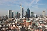
Human potential with good education and the culture of innovation are considered prerequisites for the success of the German economy and knowledge society. The automotive, commercial vehicle, electrical engineering, mechanical engineering and chemical industries are considered the most competitive sectors of German industry worldwide. The aerospace industry, the financial sector with the financial centre Frankfurt am Main and the insurance industry, especially reinsurance, are also globally important. The importance of the cultural and creative industries is increasing.
As a member of the European Union, Germany is part of the world's largest single market with a combined population of around 500 million and a nominal GDP of US$17.6 trillion in 2011. Germany is also part of the Eurozone, a monetary union with 19 member countries and a population of around 337 million. Its currency is the euro, whose monetary policy is controlled by the European Central Bank (ECB) and which is the world's second most important reserve currency as well as the world's largest currency in circulation in terms of cash value.
Income inequality in Germany was just below the OECD average in 2005. In 2008, a median disposable income was 1,252 with a Gini index of 0.29. The distribution of wealth in Germany, with a Gini index of 0.78, is much more concentrated than the distribution of income. According to Credit Suisse, total private wealth amounted to $12.4 trillion in 2016. On average, each adult person in Germany had assets of $185,175 in 2016 (median assets: $42,833). This is 27th in the world and less than in most of Germany's neighbouring countries - one cause or consequence (depending on interpretation) is a low share of real estate ownership. There were 1,637,000 millionaires in Germany in 2016 and a total of 114 billionaires (in US dollars) in 2017, the third highest number worldwide.
Foreign trade and economic development
For decades, the German economy recorded more exports than any other country ("world export champion"). Germany was consistently the country with the third highest value of exports worldwide in the 2010s. Exports reached a total value of 1,205 billion euros in 2020, while the value of goods imported was 1,025 billion euros - a foreign trade balance surplus of 180 billion euros. The current account surplus was the highest in the world in 2016 and amounted to more than 7 per cent of economic output, which has partly met with criticism from home and abroad.
The most important trading partners (imports and exports) in 2020 were the People's Republic of China (213 billion euros in trade), the Netherlands (173 billion euros), the United States (172 billion euros), France (147 billion euros), Poland (123 billion euros) and Italy (114 billion euros). The largest export markets were the USA, the PR China, France and the Netherlands. Germany conducted more than half of its foreign trade with the states of the European Union. The value of all exports of goods and services accounted for 47 per cent of economic output in 2019, which is a high figure among larger economies. The country is therefore potentially vulnerable to fluctuations in global trade, even though the upswing of recent years was primarily consumption-driven.
Germany was hit by the international financial crisis at the end of 2008 and in 2009, which led to a 5.6 percent decline in gross domestic product in 2009. Subsequently, the German economy grew again significantly by 4.1 and 3.7 per cent (2010 and 2011) and more moderately in 2012 and 2013 with 0.5 per cent each. In 2014, economic growth accelerated again to 1.9 per cent and in 2015 and 2016 further to 1.7 and 1.9 per cent respectively. For 2017, growth was 2.2 per cent.
Between 2000 and 2011, the annual average inflation rate was a minimum of 0.3 % (2009) and a maximum of 2.6 % (2008). At the beginning of 2015, Germany recorded slight deflation (-0.3 %) for the first time since 2009 due to the low oil price.
See also: Economy in Germany against the background of globalisation, List of countries by exports and List of countries by gross domestic product
Automotive industry
Germany is internationally renowned for the development and production of passenger cars with internal combustion engines. The automobile was invented in Germany in 1886 by Carl Benz, which laid the foundation for the development of what is currently the world's third largest automotive industry. Today, corporations such as Volkswagen, Mercedes-Benz and BMW are an important part of the German economy. In 2017, the German automotive industry generated more than 400 billion euros in sales with over 800,000 employees in Germany, and about seven percent of GDP is attributable to it.
Information Technology and Telecommunications
Information and communication technology (ICT) is considered an essential location factor. The digitalisation of the German economy is being driven forward under the project name Industry 4.0. The telecommunications company with the highest turnover in Germany is Deutsche Telekom. SAP, Software AG, Wincor Nixdorf and DATEV are among the most important software manufacturers in the world with headquarters in Germany. In the hardware sector, development is particularly important, for example at Infineon and FTS. In addition to established companies in the ICT sector, innovative start-ups and e-ventures are gaining importance in Germany.
In 2017, 88 percent of the population had internet access; about 87 percent had access to broadband.
See also: Internet in Germany and German mobile telephony market
Energy
→ Main article: German energy industry
| Primary energy consumption in Germany | ||
| Energy source | 1990 | 2019 |
| Mineral oil | 35,1 | 35,3 |
| 15,5 | 25,0 | |
| 1,3 | 14,7 | |
| Lignite | 21,5 | 9,1 |
| Hard coal | 15,5 | 8,8 |
| 11,2 | 6,4 | |
| Other | 0,7 | |
In 2010, Germany was the fourth largest producer of primary energy in Europe and was ranked 24th among the world's energy producers. In 2012, primary energy consumption in Germany was 13,757 PJ (2005: 14,238 PJ). Measured by this, the country is the second largest national energy consumer in Europe and seventh largest in the world. In 2012, electricity was supplied by 1059 companies headquartered in Germany.
In 2016, renewable energies supplied 29.2 percent of gross electricity production, 13.4 percent of final energy demand in the heating sector and 5.1 percent of fuels. Within the framework of the energy transition, it is planned to increase the share of renewable energies in electricity consumption to 80 percent by 2050, to reduce primary energy consumption by 50 percent compared to 2008 and to reduce greenhouse gas emissions by 80-95 percent compared to 1990 in line with EU targets. Overall, at least 60 percent of energy consumption is to be covered by renewable energies in 2050.
Tourism
→ Main article: Tourism in Germany
In 2016, Germany was one of the seven most visited countries in the world, with over 35 million foreign overnight visitors per year.
About 4,000 of Germany's 11,116 municipalities are organised in tourism associations, 310 of which are recognised as spas, seaside resorts and health resorts. There are 6,135 museums, 366 theatres, 34 leisure and adventure parks, 45,000 tennis courts, 648 golf courses, 190,000 km of hiking trails, 40,000 kilometres of long-distance cycle paths and holiday and theme roads.
Of outstanding importance is business and congress tourism; Germany is the most important international trade fair location with several world-leading trade fairs. The International Tourism Exchange Berlin is the world's leading tourism trade fair. Germany also has the highest density of festivals.


Traffic
The Logistics Performance Index 2018 compiled by the World Bank identifies Germany as the country with the best infrastructure worldwide.
Due to its dense population and central location in Europe, Germany has a very high volume of traffic. It is an important transit country, especially for freight transport. Through the concept of Trans-European Networks, Germany is promoted as a transfer area between the first European core economic area, the so-called Blue Banana, and the core economic area in East-Central Europe. Important projects in these networks are the railway axes Lyon/Genoa-Rotterdam/Antwerp, POS (Paris-East France-South-West Germany), PBKA (Paris-Brussels-Cologne-Amsterdam), Berlin-Palermo and the Magistrale for Europe. Furthermore, Germany is the western starting point of several pan-European transport corridors.
Freight traffic has steadily shifted from rail to road in recent decades. As a countermeasure, a motorway toll for trucks was introduced in 2005. Nevertheless, carbon dioxide emissions from road freight transport in Germany increased by 20 percent from 1995 to 2017. In rail transport, Deutsche Bahn has closed unprofitable branch lines, freight and marshalling yards and discontinued long-distance passenger services in recent years. The Federal Transport Infrastructure Plan 2030 is valid for the period from 2016 to 2030.
Road traffic
The Romans laid out paved roads in Germany, which then fell into disrepair. The first roads were built in the 18th century. The invention of the automobile gave new impetus to road construction. The world's first motorway, the AVUS, was opened in Berlin in 1921. Road transport replaced the railway as the most important mode of transport in the second half of the 20th century. Germany has one of the densest road networks in the world. In 2012, the federal trunk road network comprised 12,845 kilometres of motorways and 40,711 kilometres of federal roads. Furthermore, the supra-local road network comprised 86,597 kilometres of state roads, 91,520 kilometres of district roads and the roads connecting municipalities.
On 1 January 2020, 47.7 million passenger cars were registered in Germany. The vehicle population of all motor vehicles and trailers was 65.8 million. From 1995 to 2017, absolute carbon dioxide emissions from road freight transport in Germany increased by 20 percent.
In order to reduce the dangers and burdens of road traffic, pedestrian zones, traffic-calmed zones and speed 30 zones have been established in many German cities. The number of people killed in road traffic has decreased continuously since then; in 2015, there were 3,459 people, in 2019 there were still 3,046. Cycling is playing an increasing role, and its expansion is supported politically, for example through the Cycling Plan.
See also: List of federal motorways in Germany
Rail transport
Germany's railway network is about 38,500 kilometres long and is used by up to about 50,000 passenger and goods trains every day. As part of the railway reform, the state railways Deutsche Bundesbahn (West) and Deutsche Reichsbahn (East) were transferred to the privately owned company Deutsche Bahn AG on 1 January 1994. It organises the majority of rail transport in Germany. Around 350 other railway companies operate the German railway network. While the state has withdrawn from operational management, it finances the majority of network maintenance and expansion as well as (via regionalisation funds) largely regional transport.
Regional (Interregio-Express (IRE), Regionalbahn (RB), Regional-Express (RE) and S-Bahn (S)) and long-distance traffic (Intercity (IC), Eurocity (EC) and Intercity-Express (ICE)) largely run according to a timetable. For long-distance trains, high-speed lines with a total length of about 2000 kilometres are available.
See also: History of the railway in Germany and List of railway lines in Germany
Local traffic
In 1881, Werner von Siemens opened the world's first electric tram in Lichterfelde near Berlin. This mode of transport dominated public transport in Germany's larger cities in the first half of the 20th century. After the Second World War, many were closed down, especially in West Germany, while others were converted into light railways with inner-city tunnel routes. They were replaced by omnibus services, which are also available throughout the countryside and provide access to almost every town. However, bus networks have been thinned out by population decline in rural areas and often replaced by call-bus systems. In the largest cities, subways were built in the 20th century and combined with suburban trains to form a rapid transit network for the city and surrounding areas.
Since the 1980s, cycle path networks have been created and expanded in the cities and in the countryside, so that today the bicycle again plays an increasing role in local transport. In an international comparison, public transport in Germany's larger cities is characterised by a high level of effectiveness and coverage.
Air traffic
With around 700 airfields, Germany has one of the highest densities of runways in the world.
Frankfurt Airport is Germany's largest airport in terms of passengers (2016: 60.77 million), Europe's fourth largest and Europe's largest airport in terms of cargo volume (2015: 2.1 million tons). Lufthansa, Germany's largest airline, operates intercontinental hubs in Frankfurt and at Germany's second-largest airport in Munich. The federal government and the states of Berlin and Brandenburg are the sole shareholders of Flughafen Berlin Brandenburg GmbH, which operates Berlin Brandenburg Airport "Willy Brandt".
Germany does not have its own spaceport (or spaceport) for traffic beyond the Kármán line (100 km) into space. The German Aerospace Centre's space flight therefore mostly uses the CSG spaceport in French Guiana or the Russian-operated Baikonur Cosmodrome.
See also: List of commercial airports in Germany and List of German airports
Shipping
Due to its high share of foreign trade, Germany is particularly dependent on maritime trade. It has a number of modern seaports, but also handles large shares of its overseas trade through the ports of neighbouring countries, especially in the Netherlands. The three seaports in Germany with the highest turnover are Hamburg, Wilhelmshaven and the ports of Bremen. The JadeWeserPort in Wilhelmshaven is the only deep-water port in Germany. The most important Baltic Sea ports are Rostock, Lübeck and Kiel. Rostock-Warnemünde is the busiest cruise port in Germany.
The most important shipping routes are the Lower Elbe and the Lower Weser. The Kiel Canal is the busiest artificial shipping route in the world, and the Kadet Trench, the busiest shipping route in the Baltic Sea, lies off the German Baltic Sea coast.
There is a well-developed network of waterways for inland navigation. The most important navigable rivers are the Rhine, Main, Moselle, Weser and Elbe. Important inland canals are the Mittelland Canal, the Dortmund-Ems Canal, the Rhine-Herne Canal and the Elbe-Seiten Canal. The Main-Danube Canal crosses the main European watershed, providing a direct shipping route from the North Sea and Baltic Sea to the Black Sea. The Duisburg-Ruhrort port complex is the inland port with the highest turnover in Germany and is considered the largest inland port in Europe. The New Silk Road, an infrastructure project of the People's Republic of China, also begins and ends here and aims to link up with old trade routes.


Company
According to the World Values Survey, secular-rational values and personal self-development are valued in Germany, which is based on the pluralistic tradition of the Enlightenment. The population cites satisfaction scores above the average of developed industrialised nations in the areas of education, work-life balance, employment, environment, social relations, housing, security and subjective well-being, and below only in health. Overall, Germany scored 7 out of 10 on the OECD Better Life Index in 2015, above the OECD average (6.5; Greece 5.5, Switzerland 7.6).
In the UN's World Happiness Report 2018, Germany ranked 15th out of 156 countries.
Social
Germany has a long tradition of legally promoted social equalisation. According to the Gini index, the country is considered a society with low income inequality in international comparison. The German state offers its residents extensive legal entitlements to family support and social security. The history of social insurance began in the German Empire. Later governments have gradually expanded it and supplemented it with additional social transfer benefits, which means that today a large part of the state budget is spent on social welfare.
Employees are required to be members of the social insurance system, which consists of five pillars: health, accident, pension, long-term care and unemployment insurance. The basic social security is primarily financed by contributions of the insured, deficits are compensated by tax money.
In 2010, 830,000 Euro millionaires (1% of the population) in Germany had total assets of €2,191 billion, while around 12.4 million people (15.3% of the population) lived in relative poverty or were considered at risk of poverty. In 2016, 19.7 % of the population were at risk of poverty or social exclusion (EU: 23.5 %).
Domestic transfers include the Länder fiscal equalisation scheme, which obliges federal states with high tax revenues to transfer part of their income to worse-off states so that living conditions in Germany do not diverge too much. The solidarity surcharge levied on income tax is intended to alleviate division-related burdens in the new Länder.
The General Equal Treatment Act aims to prevent discrimination on the grounds of gender, race, ethnic origin, religion or belief, disability, age or sexual identity (such as homosexuality).
See also: List of trade unions in Germany
Health
→ Main article: Germany's health system
The German health care system is highly developed, as illustrated by the very low rate of infant mortality of about 3.5 boys and 3.0 girls per 1000 births and a high life expectancy, which in 2016 was 78.2 years for men and 83.1 for women. Yet, in 2015, poor men had a life expectancy of 70.1, and affluent ones 80.9 years (women: 76.9 and 85.3 years). In 2015, a study by the OECD found that patients in Germany had short waiting times, little financial outlay of their own and plenty of choice. Prevention, on the other hand, is in need of improvement, which is shown by a high number of diseases such as cardiovascular diseases and diabetes. The quality, however, is shown, among other things, by the fact that a stroke is often survived. The number of hospital stays and operations is in the top group internationally, but so are the costs for medicines; in 2013, health expenditure accounted for 11 % of GDP (OECD average: just under 9 %).
The health care system comprises service providers such as doctors, pharmacists, nursing staff, the state (federal government, Länder and municipalities), the health, accident, nursing care and pension insurance funds, the associations of panel doctors, the employers' and employees' associations, other interest groups as well as the patients, partly represented by associations and self-help organisations. Hospitals are often run on a non-profit basis, but are increasingly privatised. Other care services are largely provided privately by freelancers (practising doctors and pharmacists and companies, for example in the pharmaceutical and medical technology industry). The state is only involved as a service provider to a lesser extent with health authorities, municipal hospitals and university clinics.
The majority of the population belongs to the statutory health insurance (GKV), whose contributions are mainly based on the level of income. Family members without an income of their own are often co-insured free of charge. Entitlement to benefits is independent of the contribution level. About 10.8 per cent of those insured had private health insurance in 2017.
Education
→ Main article: Education system in Germany and School system in Germany
Today's German education system has its roots, among other things, in the Humboldtian educational ideal, which was once exemplary worldwide, and the Prussian educational reforms. Its organisation is the responsibility of the Länder ("cultural sovereignty"), but is coordinated by nationwide conferences of the Ministers of Education and Cultural Affairs, which also set common educational standards. Depending on the federal state, there are pre-school periods and compulsory schooling lasts nine to thirteen years. Attendance at general schools lasts at least nine years. After that, secondary schools or vocational schools can be attended. Most German Länder have a structured school system with Hauptschule, Realschule and Gymnasium, but there are tendencies towards more comprehensive schools and all-day schools. The higher education entrance qualification is acquired - depending on the federal state - after twelve or thirteen school years.
Practically all young adults attend a post-secondary educational institution after school. Trainees in companies usually attend vocational school one or two days a week, which is known worldwide as a successful model of dual education. The academic equivalent is dual study. Students can choose between university and application-oriented universities (Fachhochschulen). The proportion of university graduates has risen steadily since the 1970s.
Continuing vocational training also plays a major role. The Federal Employment Agency provides continuing education vouchers for the unemployed. Before their vocational training, young people can also complete so-called voluntary services, such as a voluntary social year or a voluntary ecological year. Other popular transition activities are voluntary military service and stays abroad, for example in the form of work & travel or youth exchange.
In school performance studies, Germany often scores only average or even below average in a global comparison. In the most recent PISA studies, Germany was able to improve: In the 2015 PISA ranking, German students achieved 16th place out of 72 in mathematics, 15th place in science and 10th place in reading comprehension. The performance of German pupils was thus above the OECD average in all three categories. However, the OECD criticises German education policy in the PISA studies because the school success of children with socially or educationally disadvantaged parents and with a migration background in particular is below average. Contrary to the reform efforts of the last decades, it is still statistically significantly less likely that working-class children achieve the Abitur (Allgemeine Hochschulreife) or a university degree than children from the middle or upper classes. In addition, there would be a lack of individual differentiation and support for both high-performing and low-performing pupils. Expenditure on education (4.6 % of gross domestic product) is below average in an OECD comparison. School support at primary school age is considered to be in need of improvement, especially with regard to childcare facilities and targeted support for weaker pupils.
Of the working-age population, about 2.3 million (4%) were considered fully illiterate and 7.5 million functionally illiterate in 2011.
See also: List of universities in Germany
Science
Germany is an internationally important location for technology and science. Since the industrial revolution, German-speaking researchers have been instrumental in establishing empirical sciences. In particular, the economic performance of a wide range of industries and the transfer of knowledge into practice have been driven by the creative work of engineers. Around 8 per cent of all patents filed worldwide under the PCT in 2016 came from Germany; this placed Germany in fourth place behind the USA, Japan and China.
In Germany, universities, technical universities and universities of applied sciences are institutions of research and scientific teaching. The (technical) universities are entitled to doctoral and habilitation procedures. Both procedures are intended to prove education and contain scientific knowledge. With the introduction of international degree designations in the course of the Bologna Process, the previous separation of degrees between universities of applied sciences and universities is being weakened in the academic education sector. Individual higher education institutions do not provide tertiary education at all, but are set up for postgraduate education or exclusively for doctorates and habilitations. Most German higher education institutions are publicly funded, but their research is financed by third-party funds (German Research Foundation, foundations, companies and others).
In addition to the universities, there are a larger number of research organisations that are active throughout Germany and beyond. In this context, a system of division of labour between the universities on the one hand and between the universities and the non-university research institutions on the other has been created in Germany. The Max Planck Society is committed to basic research. It runs 79 institutes in Germany and has an annual budget of 1.8 billion euros. The Helmholtz Association is the largest scientific society in Germany and operates 15 so-called large-scale research centres that work on scientific complexes across disciplines. The Fraunhofer-Gesellschaft is the largest organisation of applied research. In its 56 institutes, it takes up the results of basic research and tries to make them economically accessible. It provides industry with contract research services. It gained worldwide fame through the development of the MP3 audio format. It is one of the most important patent applicants and owners in Germany. The Leibniz Association is an association of independent research institutions working in both basic and applied research.
A continuously increasing budget of over 54 billion euros in federal and state funding was distributed to universities and higher education institutions in Germany in 2017. Non-university institutes such as the Fraunhofer-Gesellschaft, Helmholtz Association, Leibniz Association, Max Planck Society, Academies of Sciences and Humanities received a further 10 billion euros.
Numerous researchers from all areas of modern science come from Germany. More than 100 Nobel Prize winners are attributed to the country. Albert Einstein and Max Planck founded important pillars of theoretical physics with their theories, on which Werner Heisenberg and Max Born, for example, were able to build further. Wilhelm Conrad Röntgen, the first Nobel Prize winner in physics, discovered and studied the X-rays named after him, which still play an important role today in medical diagnostics and materials testing, among other things. Heinrich Hertz wrote important works on electromagnetic radiation, which are decisive for today's telecommunications technology. The developments of Karl von Drais, Nikolaus Otto, Rudolf Diesel, Gottlieb Daimler and Carl Benz revolutionised transport, and the Bunsen burners and zeppelins named after their inventors are known worldwide. German space travel did decisive pioneering work in the field of space travel and space research, and today it has a powerful space agency in the form of the German Aerospace Center (DLR); moreover, Germany is the member country contributing the most to the European Space Agency (ESA).
Chemical research was shaped by Carl Wilhelm Scheele, Otto Hahn and Justus von Liebig, among others. With their successful inventions, names like Johannes Gutenberg, Werner von Siemens, Wernher von Braun, Konrad Zuse and Philipp Reis are part of general technological education. Many important mathematicians were also born in Germany, for example Adam Ries, Friedrich Bessel, Richard Dedekind, Carl Friedrich Gauss, David Hilbert, Emmy Noether, Bernhard Riemann, Karl Weierstrass and Johannes Müller (Regiomontanus). Other important German researchers and scientists are the astronomer Johannes Kepler, the archaeologist Heinrich Schliemann, the biologist Christiane Nüsslein-Volhard, the polymath Gottfried Wilhelm Leibniz, the naturalist Alexander von Humboldt, the religious researcher Max Müller, the historian Theodor Mommsen, the sociologist Max Weber and the medical researcher Robert Koch.
See also: List of German inventors and discoverers


See also
![]()
Portal: Germany - Overview of Wikipedia content on the topic Germany
- FRG
- National symbols for Germany
Questions and answers
Q: What is the full name of Germany?
A: The full name of Germany is the Federal Republic of Germany (Bundesrepublik Deutschland).
Q: What countries border Germany?
A: To the north of Germany are the North and Baltic Seas, and the kingdom of Denmark. To the east of Germany are the countries of Poland and the Czech Republic. To the south of Germany are the countries of Austria and Switzerland. To the west of Germany are France, Luxembourg, Belgium, and Netherlands.
Q: How large is Germany in terms of area?
A: The total area of Germany is 357,021 square kilometres (137,847 square miles).
Q: What type climate does most parts in German have?
A: Most parts in German have warm summers and cold winters.
Q: How many people live in German as at March 2021?
A: As at March 2021, there were 83.1 million people living in German which makes it one largest population in Europe (excluding Russia).
Q: What was German called before it was called ‘Germany’?
A: Before it was called 'Germany', it was called 'Germania'.
Q: When did East Berlin build a wall between West Berlin?
A: On 13 August 1961, East Berlin started building a wall between West Berlin.
Related articles
Author
AlegsaOnline.com Germany — the Federal Republic of Germany Leandro Alegsa
URL: https://en.alegsaonline.com/art/38493
Sources
- bundespraesident.de : "Repräsentation und Integration"
- bamf.de : Migrationsbericht 2015
- ekd.de : Numbers and Facts about Church Life in Germany 2016 Report
- destatis.de : "Population by sex and citizenship"
- imf.org : "World Economic Outlook Database, April 2017, Germany"
- appsso.eurostat.ec.europa.eu : "Gini coefficient of equivalised disposable income (source: SILC)"
- hdr.undp.org : "2016 Human Development Report"
- destatis.de : Bevölkerung auf Grundlage des Zensus 2011
- worldatlas.com : "The 10 Most Populated Countries In Europe"
- bloomberg.com : "Germany Top Migration Land After U.S. in New OECD Ranking"
- europa.eu : "History of the European Union"
- laender-lexikon.com : "The foundation of the first German emipre"
- stefanjacob.de : "A timeline of German – The second German empire"
- stefanjacob.de : "A timeline of German – The Third Reich"
- 123helpme.com : "History of Nazi Germany"