Kantō Plain: Japan’s largest lowland basin and its geography
The Kantō Plain is Japan’s largest plain on central Honshū, encompassing Tokyo and surrounding prefectures. This article explains its geography, geology, history, land use, and notable risks and features.
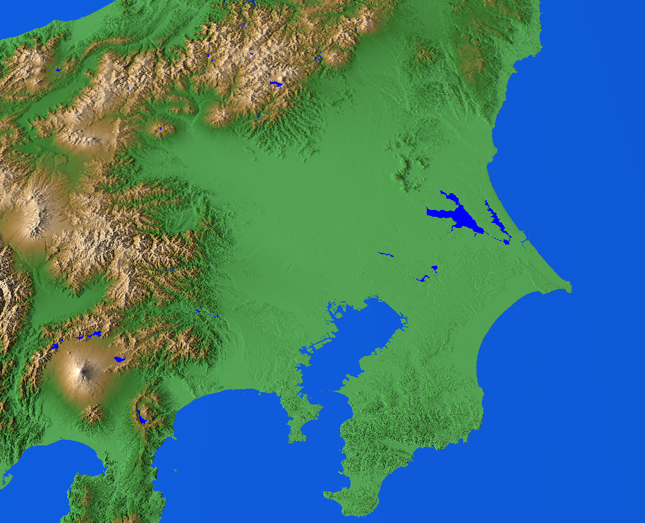
The Kantō Plain is the largest and most populous lowland in Japan, occupying roughly 17,000 km² on central Honshū and forming the core of the greater Tokyo metropolitan area. The plain includes or reaches into the prefectures of Tokyo, Saitama, Chiba, Kanagawa, Ibaraki, Tochigi and Gunma and opens toward Tokyo Bay on the Pacific coast. Its Japanese name and common romanizations are frequently shown in place names and studies: 関東平野 and Kantō heiya. As a geographic feature it is recognized among Japan’s major plains and lowland regions for both its size and strategic importance (plain, Japan).
Image gallery
2 Images
Physical characteristics
The landscape is primarily low and gently sloping, formed of broad plateaus, river terraces and shallow valleys. Large plateaus are commonly dissected into smaller remnants by tributaries and alluvial fans, and volcanic ash (often referred to as loam) from surrounding volcanoes has deposited extensive soil layers across these surfaces. The Tone (Tonegawa) and other rivers drain the basin toward Tokyo Bay; the plain is often described as a basin that tilts toward the bay and the Pacific coast (Honshū, Tokyo). Plateaus and hills show a gradual slanting, reflecting long-term geomorphic processes (Saitama Prefecture).
Geology, tectonics and hazards
The Kantō Plain sits above sedimentary fill and older basement rocks and has been shaped by tectonic subsidence and repeated volcanic deposition. Continued crustal movement causes slow sinking in parts of the basin; human activities and sediment loading have also contributed. Because much of the plain is composed of unconsolidated sediments and recent volcanic ash, it is vulnerable to liquefaction and severe shaking during earthquakes, a risk underscored by historic events and modern hazard assessments (Kanagawa Prefecture, Chiba Prefecture, Gunma Prefecture).
Human use and infrastructure
Historically the plain supported extensive rice cultivation and other agriculture thanks to fertile alluvial soils and abundant water. Over the last century urban growth—centered on Tokyo, Yokohama and nearby cities—has converted much agricultural land into residential, commercial and industrial zones. Major engineering works such as river channeling, flood control levees and land reclamation in Tokyo Bay have reshaped the coast and reduced seasonal flooding in some areas, while creating new industrial and port facilities. Transportation networks that radiate from central Tokyo use the plain’s relatively flat terrain, enabling concentrated rail and highway systems that serve millions daily (Tochigi Prefecture, plateaus).
History and development
Archaeological and historical records show long-term human occupation and land modification. Edo (now Tokyo) grew from a riverside castle town into one of the world’s largest cities, stimulating canal and reclamation projects and later modern urban expansion. Postwar economic growth accelerated industrial and suburban development, adding layers of infrastructure and prompting comprehensive planning to manage water, transportation and seismic risk. Notable engineering responses include modification of major rivers and creation of artificial islands and port complexes (river valleys, volcanoes).
Significance and notable facts
- The plain contains Japan’s largest metropolitan concentration and much of its political and economic center, including government, finance and industry.
- Its soils—partly derived from volcanic ash—support remaining agriculture in peri-urban areas and specialized crops.
- Because of its basin-like structure and continuing subsidence, planners treat flood control, earthquake resilience and land-use management as ongoing priorities (basin, tectonic changes).
For further reading and maps of the region, consult geographical surveys and regional planning documents that cover landform classification, seismic hazard zones and urban development on the Kantō Plain (関東平野, Kantō heiya).
Related articles
Author
AlegsaOnline.com Kantō Plain: Japan’s largest lowland basin and its geography Leandro Alegsa
URL: https://en.alegsaonline.com/art/52203