Mount Woodroffe (Ngarutjaranya) — highest peak of South Australia
Mount Woodroffe (Ngarutjaranya), 1,435 m high, is South Australia’s tallest peak. A granite and gneiss summit in the Musgrave Ranges, it lies on Anangu country and holds strong cultural and geological significance.
Overview
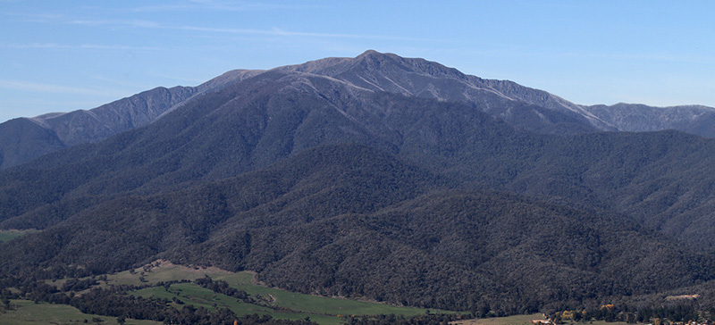
Mount Woodroffe, known in the Pitjantjatjara language as Ngarutjaranya, is the highest point in South Australia, reaching 1,435 metres above sea level. The peak stands in the remote northwest of the state and forms a distinct landmark within an otherwise low-lying, arid region. It is valued for its visible prominence, its geology, and its continuing cultural importance to the local Aboriginal communities.
Image gallery
2 Images
Location and landscape
The mountain is part of the Musgrave Ranges, a compact series of ridges and peaks that rise roughly 700–800 metres above the surrounding plains. The ridgelines and rocky summits contrast with broad, flat desert country and episodic drainage lines. The elevation produces local changes in microclimate compared with lower-lying surrounds, supporting slightly different vegetation in sheltered gullies.
Geology
Mount Woodroffe is predominantly composed of crystalline rocks, notably granite and gneiss. These hard, resistant rock types form the core of the ranges and explain the mountain’s blocky, rugged appearance. Over geological time, weathering and erosion have sculpted the massif into ridges, tors and valleys, leaving the summit as a lasting remnant of ancient crustal processes.
Ecology and environment
Vegetation on the upper slopes is generally sparse and adapted to shallow soils and exposure, while sheltered hollows and drainage lines support shrubs, grasses and small trees where water is more available after rains. Wildlife is typical of arid central Australia: small mammals, reptiles and birds that use rocky refuges and seasonal food resources. The remote setting has limited disturbance, but fragile soils and vegetation mean the area can be vulnerable to off-road travel and other impacts.
Cultural significance
For the local Pitjantjatjara people the mountain is Ngarutjaranya and is embedded in traditional knowledge and songlines. In Pitjantjatjara stories and the broader Dreaming framework, the peak is associated with ancestral beings such as Ngintaka and continues to be a place of cultural meaning, memory and custodial responsibility. Respect for cultural protocols is fundamental for anyone seeking to visit or study the area.
European exploration and naming
The name Mount Woodroffe was given by the explorer William Gosse, who sighted the peak in July 1873 and named it after George Woodroffe Goyder, a prominent surveyor and administrator associated with colonial northern and southern Australia, including work relevant to the Northern Territory. These historical associations form part of the recorded European history of the region but exist alongside much older Indigenous histories.
Access, management and contemporary use
The mountain lies within lands managed by Anangu communities, and access is regulated. Visitors must obtain permission to enter the Anangu Pitjantjatjara Yankunytjatjara lands; this requirement helps protect cultural sites and fragile environments and ensures community control over visits. Practical access is by unsealed tracks and requires capable vehicles and experience in remote travel; services and facilities are limited.
Research, conservation and visitor guidance
Mount Woodroffe attracts interest from geologists, ecologists, cultural researchers and experienced bush travellers. Any research or visitation should be arranged in consultation with custodial authorities. Conservation considerations include protecting vegetation, preventing erosion, and respecting sacred sites. Local land management bodies provide current guidance on permitted activities and protocols.
Notable facts
- Highest point in South Australia at 1,435 m (4,708 ft).
- Indigenous name: Ngarutjaranya; important in Pitjantjatjara culture and local traditions.
- Part of the Musgrave Ranges, composed largely of granite and gneiss.
- Named by William Gosse in 1873 for George Woodroffe Goyder, linked to surveying in southern and northern regions such as the Northern Territory.
- Entry requires permission from custodial authorities on APY lands.
For those seeking further information, regional land management organisations and Indigenous custodians are the appropriate sources for current access procedures, cultural guidance and any permitted research arrangements. General geographic summaries and historical overviews are available through official state and regional resources and through publications that cover the Musgrave Ranges and central Australian landscapes.
Related articles
Author
AlegsaOnline.com Mount Woodroffe (Ngarutjaranya) — highest peak of South Australia Leandro Alegsa
URL: https://en.alegsaonline.com/art/67120
Sources
- ga.gov.au : "Mount Woodroffe"
- placenames.sa.gov.au : "Mount Woodroffe, South Australia"
- waru.org : "Permits"