Diomede Islands (Big Diomede and Little Diomede)
Two small islands in the Bering Strait that form the near‑shore boundary between the United States and Russia; separated by the international border, the International Date Line and a short stretch of sea.
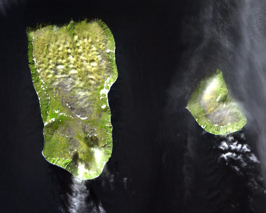
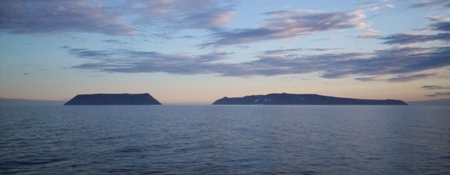
The Diomede Islands are a pair of rocky, tundra‑covered islands in the middle of the Bering Strait, roughly midway between mainland Alaska and Siberia. Known in Russian as the Gvozdev Islands, they are commonly called Big Diomede and Little Diomede. Despite their proximity, the two islands sit in different countries: Big Diomede (also called Ratmanov, Imaqliq or Nunarbuk) belongs to Russia, while Little Diomede (also known as Krusenstern or Ignaluk) is part of the United States. The narrow channel that separates them is only a few kilometres wide at its narrowest point, but it marks an international and cultural divide.
Image gallery
6 Images


Geography and environment
The islands form a small archipelago in a region where the Chukchi Sea meets the Bering Sea. Big Diomede is the larger and more rugged of the two; Little Diomede is smaller and supports a modest settlement. Together they sit a short distance from Fairway Rock, a tiny islet to the southeast. Sea ice, strong winds and frequent fog shape the local environment; weather and seasonal ice influence access by boat or aircraft and have historically governed subsistence activities such as fishing and marine mammal hunting.
Political boundary and time
The dividing line between the islands coincides with an international boundary and lies close to the International Date Line. That unusual geography produced the popular nicknames "Tomorrow Island" for Big Diomede and "Yesterday Isle" for Little Diomede because the Russian island is almost a full day ahead of its American neighbour. Time differences are amplified by the islands being subject to different national time‑keeping and daylight saving rules, so travelers and residents must be attentive to contrasting calendars and clocks.
People, settlement and culture
Little Diomede hosts a small community — the village of Diomede — where an Inupiat population lives in a remote, largely subsistence economy. The village, sometimes referenced as the City of Diomede, maintains a school, a general store and crafts traditions such as ivory carving. Mail and supplies arrive by helicopter or irregular boat service when sea and weather permit. By contrast, Big Diomede has no civilian settlement today; during the Soviet period the island’s indigenous residents were relocated to the Russian mainland and a small military presence has since remained.
History, transport and proposals
The islands have served as a geographic and political landmark for centuries, used by Indigenous peoples for seasonal hunting routes and later by explorers and military forces. During the Cold War the proximity of two national territories so close together carried geopolitical significance. In recent decades engineers and planners have proposed ambitious links across the Bering Strait — concepts such as a fixed bridge or an underwater tunnel — in which the Diomede Islands would lie near the midpoint of any crossing. Those ideas remain speculative and technically challenging because of harsh weather, sea‑ice, environmental concerns and the need for international cooperation.
- Common names: Big Diomede (Ratmanov) and Little Diomede (Krusenstern or Ignaluk).
- Jurisdiction: Big Diomede — Russia; Little Diomede — United States.
- Nearby features: Fairway Rock lies a short distance to the southeast and is often mentioned in regional navigation references.
- Access and life: Weather, ice cover and limited infrastructure define transport and daily life for residents of Little Diomede; a small military installation occupies Big Diomede.
Because of their location and human story — a single channel separating two nations, opposite calendar days, and an enduring Indigenous presence — the Diomede Islands continue to attract attention from historians, geographers and those interested in Arctic life and transcontinental connections. For further geographic and historical context, readers can consult regional references and maps that describe the Bering Strait corridor and its cultural landscape — including sources linked in this article for location names and proposed infrastructure concepts.
Additional local and technical details, including navigational charts and community reports, are available through specialized resources and regional authorities; these can provide up‑to‑date information on population, services and any developments affecting the islands and nearby waters.
For more information about the setting and specific settlement sites, see local entries for each island and the village: Little Diomede village and the broader strait entry at Bering Strait.
Related articles
Author
AlegsaOnline.com Diomede Islands (Big Diomede and Little Diomede) Leandro Alegsa
URL: https://en.alegsaonline.com/art/27536
Sources
- ac360.blogs.cnn.com : "You CAN see Russia from here!"
- epa.gov : epa.gov
- commons.wikimedia.org : Diomede Islands