
Districts of Bangladesh
Bangladesh is divided into 64 districts (zilas), grouped into eight divisions and subdivided into 493 upazilas. This article explains their administrative role, history, organization and notable examples.
Overview
Bangladesh is administratively divided into 64 districts, commonly called zila in English usage and written in Bengali as জেলা (jela). Districts are the primary subnational units below the country's eight divisions and serve as the main link between central government ministries and local communities. Each district contains multiple sub-districts (upazilas), municipalities and rural councils.
Image gallery
2 Images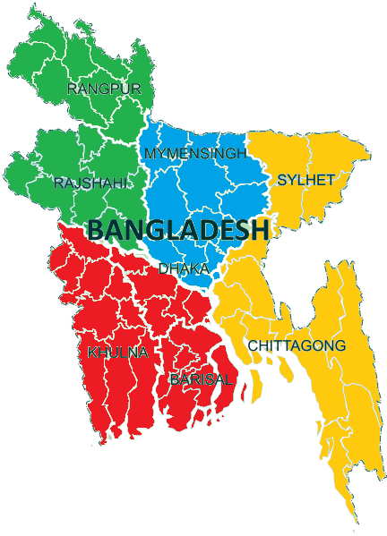

Structure and functions
Districts are headed by a civil administrator — typically the Deputy Commissioner — and have elected local bodies such as the Zila Parishad (district council) responsible for certain development and service functions. District administrations coordinate revenue collection, land records, disaster management, law and order in cooperation with national agencies, and local planning for infrastructure, health and education. Below districts are 493 upazilas, then unions, wards and villages; larger urban areas may include city corporations and pourashavas (municipalities).
Divisional grouping
The 64 districts are grouped into eight administrative divisions. These divisions provide a higher tier for regional planning and administration and vary in size, population and economic focus. The divisions are:
- Dhaka
- Chattogram (Chittagong)
- Rajshahi
- Khulna
- Barishal (Barisal)
- Sylhet
- Rangpur
- Mymensingh
For an overview of the divisional structure and its relationship to districts see eight divisions.
History and development
The district system has roots in colonial-era administrative arrangements that were adapted and reorganized after independence. Over time boundaries and the number of divisions have changed to improve governance and reflect population growth. New districts and divisions have been created through administrative reorganization to decentralize administration and bring services closer to residents.
Significance and diversity
Districts differ widely in geography, economy and culture. Some contain the national capital and major urban agglomerations, others are predominantly agricultural, while a few include important ports, hill tracts or coastal zones. For example, Dhaka District encompasses the capital city and its national institutions; Chattogram District centers on the country’s main port and industrial activity; Sylhet is known for its tea estates and overseas links; coastal districts include popular beach destinations and active fisheries. District-level administration plays a central role in development planning, disaster response and delivering public services.
Notable distinctions
Although all districts share similar legal status, they vary in population, area and administrative complexity. Large metropolitan districts may include multiple municipal corporations and city services, whereas rural districts focus on agricultural extension and local road networks. District names are officially used in both Bengali and English, and district headquarters often bear the same name as the district itself, serving as regional commercial and administrative centers.
Related articles
Author
AlegsaOnline.com Districts of Bangladesh Leandro Alegsa
URL: https://en.alegsaonline.com/art/27758