
International Date Line
Imaginary line near the 180° meridian where the calendar date changes by one day when crossed; it deviates to follow national borders and islands.
Overview
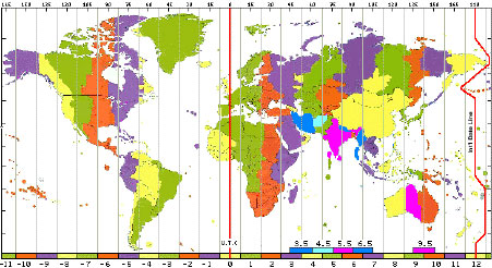
The International Date Line (IDL) is an imaginary demarcation on the Earth's surface that marks where the calendar date changes by one day. It generally follows the 180° meridian in the Pacific Ocean, but it is not a straight or legally fixed line: practical, political and human considerations have produced a stepped route that moves around countries and island groups. The convention is that crossing the line from east to west adds one calendar day, and crossing from west to east subtracts one day.
Image gallery
5 Images


Position and characteristics
The IDL is primarily a convention of timekeeping and calendar management rather than a physical or legal boundary. It exists to reconcile the 24-hour rotation of the Earth with the need for a consistent civil date. Because local times are defined by national or regional authorities, the IDL bends away from the 180° meridian to keep entire countries and island chains on the same calendar date. Examples of these deviations appear across the Pacific Ocean.
History and adjustments
The idea of a day-changing line emerged with the adoption of worldwide time zones in the 19th and early 20th centuries. Over time a number of jurisdictions have adjusted their position relative to the IDL to improve trade, governance or social convenience. Notable changes in recent decades include shifts by some Pacific island states so that their business week and dates align with major trading partners. These changes demonstrate that the exact routing of the date line is shaped by human decisions rather than astronomical necessity.
Practical effects and examples
Crossing the date line affects the calendar date but not the continuous count of hours; local clock adjustments depend on time zone differences. For instance, when comparing locations many people refer to offsets from Greenwich time or Greenwich Mean Time. A traveler moving between places such as New Zealand and Hawaii will encounter large clock and date shifts because those regions are on opposite sides of the Pacific and have substantially different UTC offsets. The practical result can be losing or gaining a calendar day while only experiencing a few dozen hours of elapsed clock time.
Implications for travel, law and communication
Airlines, shipping companies, international businesses and software systems must handle the date line correctly to avoid scheduling errors. Travelers planning journeys across the Pacific are commonly advised to confirm local dates and times for departures and arrivals. Because national governments set time zones and calendar practice, some legal and economic obligations—like tax or contractual deadlines—can be affected by where a nation places itself relative to the IDL. Timekeeping databases and international standards take these practices into account to keep records consistent.
Notable facts and distinctions
- The IDL is not governed by a single international treaty; it is a practical convention based on local laws and customary practice.
- To avoid splitting communities between two dates, the line makes detours around some territories and island groups; historical adjustments have been made for commercial or social reasons.
- Although it is typically placed near the 180° meridian, the IDL's route is irregular and subject to change if a government decides to adjust its time zone or calendar orientation.
For concise technical references and current time-zone implementations, consult authoritative time and mapping resources and time-zone databases that track national decisions and exceptions to the 180° meridian convention. Additional context and visual representations may be found through specialized geographic and governmental sources, for example those that document regional timekeeping and the practical path of the date line across the Pacific Ocean.
Further reading: time zone concepts, regional examples such as Pacific routes and historical adjustments recorded in international timekeeping databases (IDL overview, New Zealand, Hawaii).
Questions and answers
Q: What is the International Date Line (IDL)?
A: The International Date Line (IDL) is an imaginary line on the surface of the Earth that goes from north to south in the Pacific Ocean.
Q: How does the date change when you cross the International Date Line?
A: The date becomes one day later as one travels across it in western direction and one day earlier as one travels across it in eastern direction.
Q: What causes the time difference between the eastern and western sides of the International Date Line?
A: The time difference is caused by the fact that the countries on the western side of the International Date Line have the time zone 10–12 hours more than Greenwich, while the countries on the eastern side have the time zone 9–12 hours less than Greenwich.
Q: How much do you need to adjust your watch when crossing the International Date Line?
A: When travelling across the line, one's watch has to be adjusted 20–24 hours, depending on the time zones.
Q: Why do you need to adjust your watch when crossing the International Date Line?
A: You need to adjust your watch when crossing the International Date Line because the time zones on either side of the line are different.
Q: Can you give an example of the time difference between two countries on either side of the International Date Line?
A: Yes, for example, New Zealand is twelve hours ahead of Greenwich Mean Time while Hawaii is ten hours behind Greenwich Mean Time.
Q: How many hours do you need to adjust your watch if you travel from New Zealand to Hawaii?
A: If you travel from New Zealand to Hawaii, you need to adjust your watch 22 hours backwards, which is about one day.
Tags
Related articles
Author
AlegsaOnline.com International Date Line Leandro Alegsa
URL: https://en.alegsaonline.com/art/47650