Detmold — City in North Rhine-Westphalia, Germany
Detmold is a German city of about 74,000 people, seat of the District of Lippe. Known for historic architecture, cultural institutions and proximity to the Teutoburg Forest.
Overview
Detmold is a mid-sized city in Germany, located in the eastern part of the state of North Rhine-Westphalia. It serves as the administrative and cultural centre of the District of Lippe and has a population of roughly 74,000. The town sits near the northern edge of the Teutoburg Forest and functions as a local hub for government, education and tourism.
Image gallery
10 Images


History and development
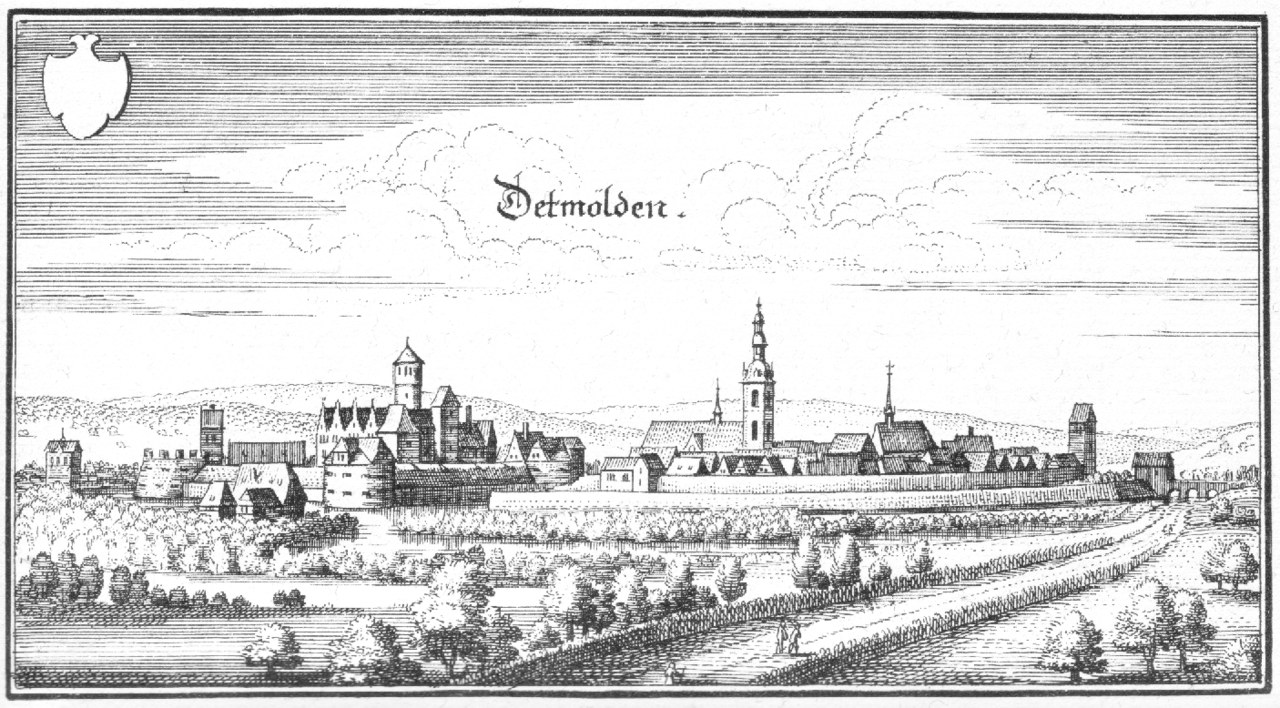
Detmold developed from a medieval market settlement into the seat of the historic principality of Lippe. Over centuries it grew around a compact old town, with timber-framed houses and civic buildings that reflect its regional importance. The area has evolved from a princely residence and regional administrative centre into a modern municipal centre while preserving many historical features.
Landmarks and culture
The city is noted for its well-preserved old town, the princely palace, and cultural institutions such as the regional theatre and museums. Nearby attractions include prominent monuments and natural sites in the Teutoburg Forest. A large open-air museum documents rural life in the region and draws visitors interested in traditional architecture and crafts.
Economy, education and public life
Detmold's economy combines public administration, small and medium-sized businesses, services, and cultural tourism. It hosts higher education institutions and conservatories that contribute to a lively cultural scene. Annual festivals, concert series and theatre productions play an important role in local life.
Transport and administration
The city is linked by regional roads and rail connections to nearby urban centres, providing commuter and visitor access. As the district capital, Detmold houses municipal and regional offices and serves as a centre for social and cultural services for the surrounding communities.
- Notable facts: historical seat of the Principality of Lippe.
- Main attractions: historic old town, palace, regional museums and nearby forest landscapes.


Geography
Geographical location
Detmold is located in the East Westphalia-Lippe region in the east of North Rhine-Westphalia on the edge of the Teutoburg Forest/Eggegebirge nature park. The south of the city area is covered by the Teutoburg Forest, the actual city lies north of it, about 30 kilometres east of Bielefeld and about 100 kilometres southwest of Hanover.
The town area is drained by the Werre, into which the Knochenbach and the Heidenbach flow in the town. The Knochenbach originates from the union of the Wiembecke and the Berlebecke in the district of Heiligenkirchen. Larger standing waters are the Meschesee in Heidenoldendorf and the Donoperteich in Hiddesen.
Geology
The city area, like the entire Lippe region, has a great geological diversity. South of Detmold's city centre runs the ridge of the Osning, which together with the Eggegebirge forms the elongated Teutoburg Forest. The Osning is built up of calcareous sandstones of the Triassic, with many fractures and folds. This fissuring is one reason why there are so many health resorts and mineral water springs in the area. The district of Hiddesen is such a health resort with a gentle climate.
The soils are of medium to very good quality. Towards the end of the last cold period, marl dust was deposited along the northern slope of the Teutoburg Forest and formed loess soils. The glaciers had advanced as far as there. The predominant subsoil is sandstone and mudstone from the Mesozoic. On it are predominantly Podsol brown earths and Pseudogley brown earths. In the northwestern part of the city, the Keuper hills of the Lipperland dominate. Along the Werre river, alluvial soils run through the urban area from the southeast to the northwest. In the higher areas of the Osning ridge, the upper layer consists of the shell limestone, in which fossils can often be found.
A well-known geologist who explored the sandstones of the Teutoburg Forest was the grammar school professor Otto Weerth.
Exhibits on the geology of Detmold are on display in the Lippisches Landesmuseum or can be found there in the collection.
The suitability of the urban area of Detmold for the use of geothermal heat sources by means of geothermal probes and heat recovery by heat pump heating systems varies greatly depending on the location. There are locations with low suitability, but also those with very good suitability (cf. the adjacent map).
Extent and use of the urban area
The town, classified as a "large medium-sized town", covers an area of 129.39 square kilometres. The municipal area has a maximum extension both in east-west direction and in north-south direction of about 15.5 kilometers.
|
| Agricultural land | Forest area | Building, | Traffic area | Water surface | Sports and green area | otheruse |
| Area in km² | 52,11 | 42,50 | 20,97 | 8,41 | 0,82 | 4,14 | 0,44 |
| Percentage of total area | 40,27 % | 32,85 % | 16,21 % | 6,50 % | 0,63 % | 3,20 % | 0,34 % |
Neighboring communities
Detmold is surrounded only by towns and municipalities of the district Lippe, these are (clockwise starting in the north) Lemgo, Blomberg, Horn-Bad Meinberg, Schlangen, Augustdorf and Lage.
City breakdown
According to § 3 para. 1 of its main statutes, the city of Detmold is divided into the following 27 districts:
| District | Inhabitants | Area |
|
| Barkhausen | 00.178 | 05,31 | 0034 |
| Bentrup | 00.367 | 03,25 | 0113 |
| Berlebeck | 02.233 | 12,61 | 0177 |
| Brokhausen | 00.505 | 04,10 | 0123 |
| Detmold-North | 28.017 | 11,80 | 2374 |
| Detmold South | |||
| Diestelbruch | 02.162 | 04,73 | 0457 |
| Hakedahl/Herberhausen | 02.202 | 03,48 | 0633 |
| Heidenoldendorf | 08.113 | 06,14 | 1321 |
| Heiligenkirchen | 03.143 | 09,99 | 0315 |
| Hiddesen | 07.375 | 11,35 | 0650 |
| Hornoldendorf | 00.145 | 03,92 | 0037 |
| Jerxen-Orbke | 03.252 | 03,01 | 1080 |
| Klüt | 01.672 | 03,01 | 0555 |
| Lossbruch | 00.798 | 01,05 | 0760 |
| Mosebeck | 00.433 | 04,21 | 0103 |
| Niederschönhagen | 00.076 | 02,60 | 0029 |
| Nienhagen | 00.318 | 03,68 | 0086 |
| Niewald | 00.057 | 01,38 | 0041 |
| Oberschönhagen | 00.072 | 04,10 | 0018 |
| Oettern-Bremke | 00.151 | 03,25 | 0046 |
| Pivitsheide V. H. | 03.086 | 03,45 | 0894 |
| Pivitsheide V. L. | 06.414 | 05,90 | 1087 |
| Remmighausen | 01.714 | 03,77 | 0455 |
| Schönemark | 00.211 | 04,50 | 0047 |
| Spork Oakwood | 03.162 | 03,20 | 0988 |
| Vahlhausen | 00.534 | 02,48 | 0215 |
See also: List of places in the district of Lippe
Climate
The Detmold city area belongs to the maritime climate region of northwest Germany. The average annual temperature is about 9 °C, the southern outskirts of the city are colder, while the more northern periphery is warmer than average. Monthly means vary regionally from about 0 °C in January to 17 °C in July/August. The annual precipitation amounts to about 900 millimetres of water column, increasing towards the Teutoburg Forest. The average annual solar radiation is 955 kilowatt hours per square meter.
For the Detmold district Hiddesen, which is situated relatively high and directly at the Teutoburg Forest, the following climate values result, which are cooler and more humid compared to the city centre:
| Climate Hiddesen (180 m)
Source: City of Detmold | |||||||||||||||||||||||||||||||||||||||||||||||||||||||||||||||||||||||||||||||||||||||||||||||||||||||||||||||||||||||||||||||||||||||||||||||||||||||||||||||||||||||||||||||||||||||||||||||||||||||||||||||
See also: Climate in East Westphalia-Lippe


Politics
City Council
The city council currently has 46 members. In addition, there is the mayor as chairman of the council. There was no fixed coalition. In 2020, two new factions entered the city council. The Detmold Alternative (DA) achieved less than 1% of the votes and thus lost its only seat in the council.
City Council Election 2020
Voter turnout: 49.3
%
40
30
20
10
0
33,0
26,0
18,9
4,5
4,2
3,7
2,8
2,7
2,6
1,2
gains and losses
compared to 2014
%p
8
6
4
2
0
-2
-4
-6
-8
-10
−8,6
−1,9
+7,1
+4,5
+0,5
+0,8
−1,7
+2,7
−2,7
+1,2
Template:Election Chart/Maintenance/New Result not 100%
Template:Election Chart/Maintenance/Old Result Not 100%
The following table shows the election results since 1975:
| 2020 | 2014 | 2009 | 2004 | 1999 | 1994 | 1989 | 1984 | 1979 | 1975 | |||||||||||
| Party | Seats | % | Seats | % | Seats | % | Seats | % | Seats | % | Seats | % | Seats | % | Seats | % | Seats | % | Seats | % |
| 16 | 33,00 | 19 | 41,69 | 18 | 38,55 | 17 | 37,16 | 20 | 39,78 | 24 | 42,08 | 22 | 40,86 | 22 | 42,71 | 24 | 47,63 | 24 | 45,79 | |
| 12 | 26,01 | 13 | 27,99 | 13 | 27,80 | 17 | 36,86 | 21 | 41,78 | 19 | 34,17 | 16 | 31,15 | 18 | 35,06 | 22 | 42,36 | 22 | 42,93 | |
| GREEN | 09 | 18,99 | 06 | 11,89 | 05 | 11,88 | 05 | 10,24 | 04 | 07,53 | 05 | 10,24 | 04 | 08,27 | 06 | 12,15 | - – | - – | - – | - – |
| 02 | 04,23 | 02 | 03,76 | 04 | 08,60 | 03 | 05,71 | 02 | 03,89 | 0– | 03,65 | 03 | 07,17 | 05 | 10,07 | 05 | 10,01 | 05 | 11,26 | |
| Free voters(1) | 01 | 02,61 | 02 | 05,34 | 02 | 05,20 | 03 | 07,59 | 03 | 07,01 | 03 | 05,58 | 03 | 06,38 | - – | - – | - – | - – | - – | - – |
| 01 | 02,87 | 02 | 04,52 | 02 | 03,80 | 0– | 0– | - – | - – | - – | 0– | 0– | 0– | - – | - – | - – | - – | - – | - – | |
| BREAKUP C | 02 | 03,77 | 01 | 02,97 | (0)01(2) | 02,31 | 0– | 0– | - – | - – | - – | 0– | 0– | 0– | - – | - – | - – | - – | - – | - – |
| 02 | 04,52 | 0– | 0– | 0– | 0– | 0– | 0– | - – | - – | - – | 0– | 0– | 0– | - – | - – | - – | - – | - – | - – | |
| THE PARTY | 01 | 02,77 | 0– | 0– | 0– | 0– | 0– | 0– | - – | - – | - – | 0– | 0– | 0– | - – | - – | - – | - – | - – | - – |
| DA(3) | 00 | 00,95 | 01 | 01,85 | 01 | 01,85 | 01 | 02,44 | - – | - – | - – | 0– | 0– | 0– | - – | - – | - – | - – | - – | - – |
| Single. H. (5) | 00 | 00,28 | - – | - – | - – | - – | - – | - – | - – | - – | - – | 0– | 0– | 0– | - – | - – | - – | - – | - – | - – |
| UWG(4) | - – | - – | - – | - – | - – | - – | - – | - – | - – | - – | - – | 04,28 | 03 | 06,16 | - – | - – | - – | - – | - – | - – |
| Other | - – | - – | - – | - – | - – | - – | - – | - – | - – | - – | - – | - – | - – | - – | - – | - – | - – | - – | - – | 00,02 |
| Total(6) | 46 | 100 | 46 | 100 | 46 | 100 | 46 | 100 | 50 | 100 | 51 | 100 | 51 | 100 | 51 | 100 | 51 | 100 | 51 | 100 |
| Voter turnout | 52,30 % | 51,80 % | 52,55 % | 56,29 % | 56,25 % | 81,72 % | 66,00 % | 67,86 % | 69,87 % | 85,71 % | ||||||||||
(1) Free Voters Detmold (until March 2010 FWG Detmold)
(2) The AUF city council member founded the party AUFBRUCH C - Christian Values for a Human Politics in March 2013.
(3) Detmold alternative
(4) Independent Voters' Association
(5) Individual candidate Hennig
(6 ) Without taking rounding differences into account.
The distribution of seats in the Detmold City Council after the municipal election on 13 September 2020 is shown in the adjacent diagram.
Mayor
→ Main article: List of mayors of Detmold
The mayor of Detmold since 1 November 2020 is Frank Hilker (SPD). He prevailed in the 2020 election against Jörg Thelaner (CDU) and Steffen Stelzer (Die PARTEI) in the first round. The following table shows the result of the 2020 mayoral election:
| Name | Party | 13 September 2020 |
| Frank Hilker | 54,86 % | |
| Jörg Thelaner | 37,49 % | |
| Steffen Stelzer | The PARTY | 07,66 % |
| Voter turnout: | 52,50 % |
Parliament
Detmold belongs to the state parliamentary constituency Lippe III (99), in which Dennis Maelzer (SPD) was elected as a direct candidate in the 2017 state election. At federal level, Detmold belongs to the federal electoral district Höxter - Lippe II (136), in which Christian Haase (CDU) was elected as a direct candidate in 2017.
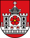
Coat of arms
|
| Blazoning: "In red a silver five-tined continuous city wall, studded at both ends with two free-standing Latin crosses, behind the first and last embrasure each a three-storey three-tined tower with one [(heraldically) closed] black window opening per storey, in between a large archway, surmounted by a central tower with a pointed roof, with a cross of paws on the top and a ball on each of the two roof ends, covered with a large Lippian rose (red leaves with yellow slugs) without sepals on a silver round shield, below in front of the middle two battlement openings two small shields, therein in silver a Lippian rose without sepals.“ |
| Coat of arms justification: The City of Detmold, newly formed in 1970, adopted by permission of February 23, 1970, the coat of arms granted to the former City of Detmold on November 24, 1955, based on the oldest city seal preserved in three impressions from 1305, 1350, and 1428, established by the Council in 1954. The building is the symbol of the town, the rose comes from the shield of the sovereigns. |
Twinning
Detmold has five twin towns and is friends with one other town. All six cities except Verona have a similar number of inhabitants as Detmold and are about the same age.
- The oldest partnership was concluded on 6 May 1976 with the Belgian city of Hasselt.
- The partnership with Saint-Omer (Pas-de-Calais) in France has existed since 29 June 1969 and was concluded on the basis of the Élysée Treaty of 22 January 1963.
- Another twin city is Savonlinna in Finland since 11 June 2004.
Student exchanges and meetings between cultural and sports clubs take place with all three cities.
- An inner-German partnership has existed with Zeitz since August 18, 1990, which began with the cooperation of city councils and administrations and today receives a further facet with the exchange of associations.
- Since 15 June 2013, there has been a town twinning with the northern Greek town of Oreokastro.
- Since 20 May 2006, there has been a friendship between the cities of Verona and Italy as a result of a long-standing school project for the joint reappraisal of German-Italian history during the period of National Socialism and Fascism.
Curiosities
In December 2002, the members of the City Council decided to reduce their attendance fees and expense allowances by 10 %. In times of tight budgets, the council wanted to set an example and save money for itself. The compensation ordinance of the NRW Ministry of the Interior, however, provided for a uniform compensation for council members. An exemption was refused after several months. The case caused a national sensation.
At the beginning of 2004, the idea arose in the district of Lippe to apply as European Capital of Culture 2010. Since it was not possible for a district to apply, the city of Detmold was to apply on behalf of the region. The city council rejected the project with a large majority.
Related articles
Author
AlegsaOnline.com Detmold — City in North Rhine-Westphalia, Germany Leandro Alegsa
URL: https://en.alegsaonline.com/art/26912