Finland: geography, society, government and economy
Overview of Finland: location, landscape, population, languages, cities, history, government, economy, culture and environment with key links and further reading.
Overview
Finland (Finnish: Suomi) is a Northern European country and a member of the European Union. It is one of the Nordic countries and part of Fennoscandia. Located between roughly the 60th and 70th parallels north, Finland is known for its extensive boreal forests, thousands of lakes and long coastline on the Baltic Sea. The modern Finnish state combines a market economy with comprehensive public services.
Image gallery
5 Images


Geography and climate
Finland shares land borders with Sweden to the west, Norway to the north and Russia to the east; to the south it faces Estonia across the Gulf of Finland. The terrain is mostly low and gently rolling, shaped by glacial activity, and includes vast forests and numerous lakes. Climate varies from temperate in the south to subarctic in the north, producing strong seasonal differences in daylight and temperature.
Population, language and society
About 5.5 million people live in Finland. The constitution recognizes both Finnish and Swedish as official languages; Finnish is the mother tongue of a clear majority while Swedish is spoken by a minority. The country emphasizes high levels of education, broadly accessible health care and social welfare policies. Finnish society is often described as placing value on equality, trust in public institutions and close-to-nature traditions.
Government and international status
Finland is a parliamentary republic with a president and a prime minister; the president plays a role in foreign and security policy. The state participates actively in regional cooperation among the Nordic countries and within European institutions. Finland declared independence from Russia on 6 December 1917 and later developed democratic political institutions while navigating complex 20th-century geopolitics.
Major cities and regions
- Helsinki — capital and main economic and cultural centre
- Espoo — technology and research suburbs
- Tampere — historic industrial and cultural hub
- Vantaa — location of the principal international airport
- Turku — maritime history and former capital
- Oulu, Kuopio, Jyväskylä and others — regional centres for education and industry
Economy and industry
Finland has a highly industrialised, open economy. Historically the country has been strong in forest products such as paper and wood-based manufacturing, and in metals including steel. In recent decades technology, electronics and services have grown in importance. Companies such as Nokia, which takes its name from the town of Nokia, played a global role in telecommunications. Finland uses the euro as its currency and engages actively in trade and research partnerships.
Education, research and innovation
The Finnish education system is widely regarded for its equitable access and strong learning outcomes; the country invests heavily in public education and research. Universities and technical institutes contribute to innovation in information technology, clean technologies and forestry-related industries. Public spending on research and development is supported by both state funding and private-sector partnerships.
Environment and conservation
Large areas of Finland are covered in protected forests, wetlands and island archipelagos. National parks and conservation programmes aim to safeguard biodiversity and to promote sustainable tourism. Environmental policy often intersects with forestry management, renewable energy initiatives and commitments under international environmental agreements.
Culture and identity
Finnish culture reflects influences from both Eastern and Western Europe, with traditions tied to language, music, literature and sauna customs. Cultural life includes a vibrant design and music scene, and longstanding folk traditions in rural areas. Public celebrations mark national milestones such as independence day and regional festivals celebrate seasonal changes.
Notable facts and rankings
Finland frequently ranks highly on international indicators for education, transparency and quality of life. It has been placed near the top of global transparency rankings, including the Corruption Perceptions Index, on multiple occasions. Public policy places emphasis on social equality, trust in institutions and environmental stewardship.
Further information and key links
- Finnish language and culture
- Country profile
- Northern Europe context
- European Union membership
- Nordic cooperation
- Fennoscandia region
- Sweden (neighbour)
- Norway (neighbour)
- Russia (neighbour)
- Estonia (across the Gulf)
- Gulf of Finland
- Baltic Sea
- Helsinki
- Tampere
- Currency and monetary matters
- Euro
- Presidential office and roles
- Sauli Niinistö
- Swedish language in Finland
- Official languages
- Independence commemorations
- History with Russia
- Espoo
- Vantaa
- Turku
- Oulu
- Lahti
- Kuopio
- Jyväskylä
- Pori
- Development status and classifications
- Paper and forest products
- Steel and metal industries
- Nokia (company)
- Town of Nokia
- Corruption Perceptions Index
Geography
With an area of 338,455 km², 303,921 km² of which is land and 34,534 km² of inland waters, Finland is slightly smaller than Germany (357,578 km²). In addition, there are 52,454 km² of marine area. Lying at a latitude between 60° and 70°, it is one of the northernmost countries in the world. One third of Finland lies north of the Arctic Circle. The north-south extension of the Finnish mainland from Nuorgam to Hanko is 1157 km, the longest east-west distance from Ilomantsi to Närpes is 542 km. When dividing the country's territory, Northern Finland is already spoken of from about the height of the Oulujärvi (German also Oulusee, northwest of the city of Kajaani). Thus Oulu, situated exactly in the middle of the country, can be called a Northern Finnish city, the landscape around Jyväskylä is called Central Finland despite its southern location.
The longest state border is with Russia in the east with 1340 km according to official data. In the north Finland borders on Norway over 736 km, the 614 km long border with Sweden in the northwest form the rivers Könkämäeno, Muonionjoki and Tornionjoki. Another 1250 km are maritime borders.
Finland is bordered by the Baltic Sea to the west and south, the Gulf of Bothnia to the west and the Gulf of Finland to the south. Almost all Finnish rivers and lakes belong to the catchment area of the Baltic Sea, only the extreme northeast of the country beyond the Maanselkä drains to the Arctic Ocean. Due to low evaporation and a constant inflow of freshwater, Finland's marine waters are much less salty than the world's oceans: with a salinity of less than 0.3%, the Bothnianwiek, for example, the northern part of the Gulf of Bothnia, is so brackish that freshwater fish can also be found in it.
The most striking feature of Finland's landscape is its abundance of lakes, which has earned the country the nickname Land of a Thousand Lakes. According to the official count, an inland body of water with an area of at least 5 ares is considered a lake, so the Finnish Ministry of the Environment puts the number of Finnish lakes at 187,888; around 56,000 lakes are at least one hectare in size. The total length of the shores of Finnish lakes is at least 186,700 km, and the number of inland islands is 98,050.
Geology
The rock base of Finland consists mainly of the Precambrian rocks of the Baltic Shield (gneisses, granites and schists). Mountain building in Finland dates back about a billion years, so that the relief today is quite flat. Only in isolated cases have particularly hard quartzites been able to withstand erosion to such an extent that they stand out from the surroundings as mountains.
Today's landscape was decisively shaped by the glaciers during the Ice Age. Glaciers covered the whole of what is now Finland until around 10,000 years ago, removing rocks and creating extensive moraine landscapes as they retreated, which in turn were reshaped by meltwater. Typical glacially shaped landscapes are round humps as a form of erosion, drumlins and oser as forms of fill. In moraine ridges such as Suomenselkä in the west and Salpausselkä in the south, glacial sediments sometimes reach a thickness of over 100 metres. With the end of the Ice Age, the meltwater formed Lake Ancylus, the forerunner of today's Baltic Sea, and covered large parts of the country. This body of water broke through to the North Sea 7000 years ago. Due to the decline of the water level and the simultaneous isostatic land uplift, more and more land masses rose from the floods in the following millennia. Inland, meltwater collected in glacial depressions and older faults, creating the Finnish lakes. The ongoing land uplift is still a landscape-shaping process today. The coast of Ostrobothnia, for example, rises up to 8 millimetres per year from the Baltic Sea. This is also the reason why floods occur there almost every spring, because the rivers have hardly any gradient towards the coast and meltwater accumulates in the inland. In the course of the last centuries, cities such as Pori and Vaasa had to be relocated several kilometres to the west because their harbours silted up.
The most widespread sediment on the surface is till, also a legacy of the Ice Age. Since there is only limestone or marble in a few places in Finland, the glacial deposits are often calcium carbonate-free. The resulting soils are therefore prone to acidification. In the lower-lying regions, which were submerged during the Ancylus Sea phase and the later Baltic precursors, the glacial sediments have often been covered by lake deposits. These, on the other hand, are mostly carbonate-rich. Thanks to these fertile clay soils, but also because of the comparatively mild climate, cereal cultivation is concentrated in the coastal regions of western and southern Finland. In inland areas, soil acidification and peat formation make the soils less suitable for arable farming and necessitate increased use of fertiliser lime, which is extracted from several limestone quarries, such as those at Pargas, Lohja and Lappeenranta.
While Finnish iron ore deposits are almost exhausted, there are still significant deposits of copper, nickel, zinc and chrome. In the 1860s, the discovery of gold in the Kemijoki river sand was followed by a veritable gold rush in Lapland. To this day, gold is panned along Lapland's rivers, partly by hand and partly industrially. A large underground mine is located in Pahtavaara near Sodankylä. Other, largely undeveloped gold deposits are scattered throughout the country, the most recent being a discovery near Kittilä in 1996 of a deposit estimated to contain 50 tonnes of gold. Finland is also the largest European exporter of talc. This mineral, needed mainly in the paper industry, is currently being mined on a large scale at Sotkamo and Polvijärvi. Other industrial minerals extracted in Finland include wollastonite, dolomite, apatite, quartz and feldspar.
Climate
→ Main article: Climate in Finland
The Finnish climate is cold temperate. Finland lies on the border between the maritime and continental climate zones. The low-pressure areas of the westerly wind zone can bring humid and changeable weather conditions. On the other hand, the ScandinavianMountains shield Finland from the Atlantic, so stable continental high-pressure zones make for cold winters and comparatively hot summers. The moderating influence of the Baltic Sea, the inland lakes and especially the Gulf Stream make the climate in Finland much milder than in other places at the same latitude. Kuopio lies at about the same latitude as Yakutsk in Siberia, but has an average annual temperature that is almost 13 °C higher.
The precipitation total in southern Finland is 600-700 mm. In the north it is significantly lower, but this is compensated for by low evaporation due to cool temperatures. The least precipitation falls in the whole country in March, the most in July or August.
· 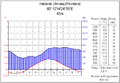
Climate diagram Helsinki
· 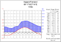
Climate diagram Kajaani
· 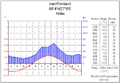
Climate diagram Inari
The climate of the country becomes significantly colder towards the north because of the north-south extension of over 1000 kilometres. While the average annual temperature in the south is 5 °C, it is only -2 °C in the north of Finnish Lapland. The duration of the thermal seasons also depends strongly on the location: While winter lasts only 100 days in the southwestern Finnish archipelago, it prevails for up to 200 days in Lapland. In the coldest month, January or February, the average temperature is between -4 and -14 °C. The coldest temperature ever recorded in Finland is the winter. The coldest temperature ever recorded in Finland was -51.5 °C in Pokka near Kittilä on 28 January 1999. A permanent snow cover usually falls between late October and early January. It develops a thickness of 20-30 cm in the south and 60-90 cm in the east and north and melts between the end of March and the end of May. Lakes freeze over between November and December and often do not thaw again until between May and June. In cold winters, the Gulf of Bothnia and the Gulf of Finland can freeze over almost completely and must be kept free with icebreakers.
Summer lasts from the end of May to mid-September in southern Finland, and starts a month later and ends a month earlier in Lapland. The temperature differences between northern and southern Finland are less pronounced in summer, with average temperatures between 12 and 17 °C in July. In southern and central Finland there are between 10 and 15 summer days when the temperature rises above 25 °C, while in the north and on the coasts there are 5-10. The highest temperature ever recorded in Finland was 37.2 °C on 28 July 2010 in Liperi.
In the areas north of the Arctic Circle, the midnight sun shines in summer and the polar night (kaamos) in winter. At the time of the summer solstice it does not get completely dark even in the south of the country (so-called white nights), in Utsjoki at the northern tip of Finland the sun does not set at all for 73 days. In Utsjoki, at the northern tip of Finland, the sun does not set at all for 73 days, which means that the sun does not rise above the horizon for 51 days in winter; in southern Finland, too, it only rises for six hours on the shortest day. Especially in the north, auroras appear in winter.
Natural areas
Finland can be divided into five major landscape areas: the coastal plains of southern Finland, the coastal plains of Ostrobothnia, the Finnish Lake District in the interior, the Finnish Hill Country in the east and Lapland in the north.
The southern Finnish coastal plain stretches from Satakunta through Uusimaa to the Russian border. It is comparatively poor in lakes and agricultural. The Greater Ostrobothnia area follows on the west coast. The flat area is intersected by numerous rivers and is also intensively farmed. The coast of Finland is a richly indented archipelago with a total length of almost 40,000 km and more than 73,000 islands of at least 500 m² in size. In terms of their number, the islands of the archipelago off Turku represent the largest archipelago in the world. The islands of the autonomous archipelago of Åland are located between 15 and 100 km from the Finnish mainland.
The moraine ridges Salpausselkä in the south and Suomenselkä in the west are the two main water divides of the country and separate the coastal areas from the Finnish Lake District (Järvi-Suomi) in the interior. The area, which is rich in bogs and forests, is the largest lake district in Europe, with some 42,200 lakes. Inland waters cover about 18% of the total area here. The main rivers of the southern half of the country, the Kokemäenjoki, the Kymijoki and the Vuoksi, also originate here. The largest lake in the country, with an area of around 4400 km², is the highly dissected Lake Saimaa in the southeast.
The Finnish Hill Country (Vaara-Suomi) extends in the east of the country from North Karelia via Kainuu to the southern parts of Lapland. The numerous hills are characteristic, but only a few of them, such as Koli (347 m) in North Karelia, stand out as mountains from the surrounding area. In the north, the hill country merges into the greater Lapland area.
Lapland is dominated by vast forest and moorland landscapes, from which rise treeless fells (tunturi) such as Pallastunturi (807 m), Yllästunturi (718 m) or Pyhätunturi (540 m). The area around Inarijärvi in northeast Lapland has a high density of lakes. The longest river in Finland is the Kemijoki, which runs for 560 km and drains a large part of Finnish Lapland. Its headwaters, like those of the other major rivers of northern Finland (Tornionjoki, Iijoki and Oulujoki), rise in the highlands on Finland's northern and eastern borders. In northern Lapland, the terrain rises towards the Scandinavian Mountains. However, Finland only shares its main ridge in the extreme northwest in the municipality of Enontekiö. All of the country's one-thousand-metre peaks are also located here. The highest elevation in Finland is Haltitunturi (1324 m), right on the border with Norway.


Nature
→ Main article: Nature in Finland
Finland is home to around 42,000 species of animals, plants and fungi, including 65 species of mammals. All in all, the biodiversity is lower than in more southern areas, but Finland's wilderness provides a habitat for numerous animals that are rarely found in the rest of Europe.
Everyman's right in Finland allows everyone to move freely in nature under certain restrictions. Berry and mushroom picking and fishing are also permitted. Hunting and fishing are widespread occupations in Finland. Six percent of the Finnish population has a hunting license.
Flora
Finland is the most densely forested country in Europe: 86% of the land area is forested. Three vegetation zones occur from north to south. Most of Finland belongs to the boreal coniferous forest zone (taiga). It is characterised by a short growing season, nutrient-poor soils on which trees grow slowly, the predominance of conifers and a small number of tree species. Pines (50%) and spruces (30%) dominate, and the most common deciduous tree species is birch (16.5%). The soil is covered with blueberry bushes and mosses, towards the north also with lichens.
Only on the southwest coast and on the offshore archipelago do mixed forests predominate. Here, tree species grow that do not normally occur in Finland, such as the oak. The extreme north of Lapland is largely treeless, with only stout birch trees growing at lower altitudes and tundra-like vegetation at higher altitudes.
One third of Finland's land area originally consisted of bogland, about half of which has been drained in recent centuries for cultivation. Peat-rich raised bogs dominate in the south, with aap bogs to the north. Most of the marshland is covered with swamp forests.
Fauna
Despite intensive hunting, moose are very numerous throughout Finland. Although more than a third of the moose are killed each year, the population remains stable at over 100,000 animals at the end of the hunting season. The large moose population poses a danger to road traffic, as serious accidents with the animals occur time and again. Reindeer can be found everywhere in the north of the country. The approximately 200,000 reindeer are semi-domesticated and roam freely throughout the year. In late autumn, their owners round up the animals and pick out the animals for slaughter. Far rarer is the wild forest reindeer. Once widespread in much of Finland, it was wiped out at the end of the 19th century, before a small population began migrating again from Russia to Kainuu and North Karelia in the 1950s. In southern and western Finland, white-tailed deer brought from America have become native in larger numbers.
The predator populations have been growing for years due to the success of conservation measures; the number of Finnish brown bears and lynxes is now over 1000 individuals each, that of wolves about 200. In the meantime, they may be hunted again to a limited extent. In the Finnish part of Lapland there is a remaining population of about 150 wolverines. The arctic fox was once quite common throughout the country, but was almost wiped out by fur hunters at the beginning of the 20th century. The red fox, on the other hand, is still very common today, and for several decades the tanuki, which has spread from Russia, has also been present.
The Saimaa ringed seal is found only in the Saimaa Lake District worldwide. This rare freshwater subspecies of ringed seal has been saved from extinction through targeted conservation measures and is therefore also the symbolic animal of nature conservation in Finland. Special protection is also given to the sliding squirrel, which is found in the European Union only in Finland and Estonia.
Finland's birdlife includes over 430 species, including golden eagles and white-tailed eagles, as well as fowl such as capercaillie, black grouse, hazel grouse and willow ptarmigan, and numerous species of waterfowl. The whooper swan is considered Finland's national bird because of its role in Finnish mythology. This species has also been saved by a strict hunting ban: While only 15 breeding pairs were counted in the 1950s, there are now around 1500 again.
Due to the numerous waters, especially the Finnish Lake District, Finland has a remarkable fish fauna with 67 species. Pike (hauki in Finnish), perch and zander, which grow in large numbers and weights in the many inland waters and the low-salt coastal region of the Baltic Sea, are particularly popular with sport fishermen. Predatory fish do not enjoy a closed season in Finland because of their strong population, so they can be caught even in winter when ice fishing. Salmonids such as brown trout, Arctic grayling, salmon, Arctic char, American char, sea trout and rainbow trout also play a major role in angling tourism and commercial fishing. Of secondary importance are peaceful fish such as carp, only found in a few waters in the south of the country due to their high heat requirement, bream, roach, rudd, ide and tench. Whitefish and vendace can be found in the open water of the large lakes. Other fish species include burbot, smelt, bleak, dace, vendace, white bream, chub and crucian carp.


Questions and answers
Q: What is the capital of Finland?
A: The capital of Finland is Helsinki.
Q: What are the official languages of Finland?
A: The official languages of Finland are Finnish and Swedish.
Q: When did Finland become independent from Russia?
A: Finland became independent from Russia on 6 December 1917.
Q: What are some important cities in Finland?
A: Some important cities in Finland include Helsinki, Espoo, Tampere, Vantaa, Turku, Oulu, Lahti, Kuopio, Jyväskylä and Pori.
Q: What is the currency used in Finland?
A: The currency used in Finland is the euro (EUR). Before 2002 it was the markka or Finnish mark (FIM).
Q: Who is the president of Finland?
A: The president of Finand is Sauli Niinistö.
Q: How many people live in Finand?
A: Approximately 5.5 million people live in Finand.
Related articles
Author
AlegsaOnline.com Finland: geography, society, government and economy Leandro Alegsa
URL: https://en.alegsaonline.com/art/34420
Sources
- stat.fi : "Finland's preliminary population figure 5,509,717 at the end of August"
- tilastokeskus.fi : "Finland's population was 5,503,297 at the turn of the year"
- imf.org : "Report for Selected Countries and Subjects"
- appsso.eurostat.ec.europa.eu : "Gini coefficient of equivalised disposable income (source: SILC)"
- hdr.undp.org : "2015 Human Development Report"
- gatestoneinstitute.org : "Finland's Immigration Crisis"
- stat.fi : Valtion talous
- stat.fi : Kansantalous
- talouselama.fi : Talouselämä 500, kymmenen suurinta
- vaalit.fi : "Central Principles of Holding Elections"