Lemgo (historic town in Lippe, North Rhine-Westphalia, Germany)
Lemgo is a historic town in the Lippe district of North Rhine-Westphalia, Germany, known for its well-preserved medieval center, half-timbered houses, educational institutions and local cultural heritage.
Overview
Lemgo is a town in the district of Lippe in North Rhine-Westphalia, Germany. It has a population of about 42,000 and occupies a place between rural landscapes and the low ridges of the Teutoburg Forest. The town combines a compact historic centre with surrounding residential districts and light industry.
Image gallery
10 Images


History and development
Founded in the Middle Ages, Lemgo grew up as a market town and regional centre and later participated in northern German trade networks. Its civic identity was shaped by medieval institutions, the Reformation and early modern urban administration. Over centuries Lemgo evolved from a market hub to a modern small city while retaining many historic structures.
Architecture and notable sites
The town is noted for its well-preserved ensemble of half-timbered houses, narrow lanes and churches. Key attractions include an ornate town hall, medieval churches and specialized museums that interpret local history, including the town's experience during early modern social tensions and witch trials. Visitors often appreciate the layered streetscape where Renaissance and baroque details meet timbered façades.
Education, research and economy
Lemgo hosts campuses and research units connected to regional universities of applied sciences, which contribute to local technology, design and health-related innovation. The economy mixes small and medium enterprises, service businesses, cultural tourism and educational services. This profile gives Lemgo a stable local labour market and attracts students and visitors.
Culture, events and transport
Cultural life includes festivals, markets and museum programming that highlight craftsmanship, regional cuisine and historical themes. Public transport links connect Lemgo with larger towns in the region, while local roads serve commuters and visitors. Outdoor recreation is accessible nearby, with walking routes that explore the surrounding countryside.
Distinctive facts
- Noted for its compact medieval core and picture-book half-timbering.
- Contains museums and historic houses interpreting local urban history.
- Combines educational institutions with small-scale industry and tourism.
Lemgo is often recommended as a destination for those interested in history, regional culture and small-city academic life, offering a mix of heritage and contemporary community activity.
Geography
Geographical position
Lemgo is located in the valley of the Bega in the hilly Lipper Bergland, a low mountain range in the north of the district of Lippe, in the northeast of the federal state of North Rhine-Westphalia. The area at the northern edge of the low mountain range threshold is bounded by the Wiehengebirge to the north, the Teutoburg Forest to the south, and the Weser River to the east, and is naturally part of the Weserbergland. Although the town was founded in the valley, it extends up to the surrounding heights of the mountains and, at the latest since the incorporations, occupies a large area in the Lipper Bergland. The lowest point is at 83 m in the valley of the Bega on the border to Bad Salzuflen in the district of Lieme. The highest point of the urban area is the Windelstein at 347 m above sea level in the Lemgoer Mark east of the core city.
The nearest larger cities are Minden (29 km away) in the north, Bielefeld (25 km) in the west and Detmold (12 km) and Paderborn (36 km) in the south. The surrounding district of Lippe belongs to the region of East Westphalia-Lippe.
Lemgo's old town lies on the north bank of the Bega, a right tributary of the Werre, which flows here from east to west.
Geology
The town lies in the Lemgo valley basin, a depression drained by the Bega river. This depression was filled in during the Ice Age by a ground moraine and then by river deposits. The surface is covered with loess. Underneath are layers of clay marl, limestone and sandstone (especially Planicosta sandstone) of the Mesozoic period. In the course of the earth's history, these sedimentary rocks have been uplifted, forming saddles, hollows, ridges and ditches. In the subsoil, the rock layers are definitely arranged next to each other. In the deep subsoil, rock salt and gypsum are dissolved, so that funnel-shaped depressions could be found there.
Lemgo's urban area is very well suited for the use of geothermal heat sources by means of geothermal probes and heat recovery by heat pump heating systems, mainly in the northwestern and southwestern parts of the municipality, and otherwise largely well suited. Only a few locations are not suitable (cf. the geothermal map of Lemgo).
Extent and use of the urban area
Lemgo is located in the rural Lipperland; the largest share of the urban area is used for agriculture, followed by forestry. Settlement and traffic areas take up about 20 %.
With incorporations, the city area extends to about 101 km². In north-south direction Lemgo extends over a maximum of 14.3 km, in east-west direction over a maximum of 13.1 km.
The land use is shown in the following table:
| Area by type of use | Area in ha | Percentage of total area |
| Agricultural area | 5638 | 55,9 % |
| Forest area | 2253 | 22,3 % |
| Settlement and traffic area | 2098 | 20,8 % |
| Water surface | 0079 | 00,8 % |
| other use | 0017 | 00,2 % |
Status: 31 December 2013
Neighboring communities
Lemgo is located relatively centrally in the district of Lippe and borders clockwise starting in the north on the towns and communities of Kalletal, Dörentrup, Blomberg, Detmold, Lage, Bad Salzuflen (all district of Lippe) and Vlotho (district of Herford).
City breakdown
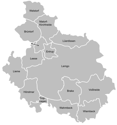
Since the municipal reform in the district of Lemgo on January 1, 1969, the city is divided into 14 districts, which are listed in the following table together with the number of inhabitants (main and secondary residences). At the end of 2016, a total of 1420 people were registered with secondary residence in the city of Lemgo, at the end of 2019 this was 1531 people.
| Local districts and population with main or secondary residence | ||||||
| Local parts | Inhabitants31 | Inhabitants31 | Inhabitants31 | Inhabitants31 | Residents | Local parts of Lemgo |
| Lemgo | 27.326 | 27.699 | 27.433 | 27.182 | 26.877 |
|
| Brake | 05.616 | 05.203 | 05.028 | 04.971 | 05.022 | |
| Brüntorf | 00.737 | 00.711 | 00.717 | 00.664 | 00.643 | |
| Entrup | 01.041 | 01.000 | 01.020 | 00.967 | 00.960 | |
| Hörstmar | 01.481 | 01.482 | 01.433 | 01.422 | 01.406 | |
| Leese | 00.632 | 00.651 | 00.671 | 00.629 | 00.603 | |
| Lieme | 02.787 | 02.827 | 02.708 | 02.631 | 02.603 | |
| Lüerdissen | 00.726 | 00.731 | 00.759 | 00.731 | 00.766 | |
| Matorf-Kirchheide | 01.492 | 01.508 | 01.539 | 01.506 | 01.511 | |
| Trophagen | 00.203 | 00.194 | 00.205 | 00.186 | 00.177 | |
| Voßheide | 01.286 | 01.280 | 01.308 | 01.175 | 01.179 | |
| Wahmbeck | 00.910 | 00.887 | 00.879 | 00.863 | 00.894 | |
| Welstorf | 00.207 | 00.196 | 00.205 | 00.177 | 00.167 | |
| Wiembeck | 00.225 | 00.217 | 00.210 | 00.167 | 00.163 | |
See also: List of places in the district of Lippe
Climate
Lemgo, like the entire Lippische Bergland, lies in the transitional area between the predominantly maritime climate and the continental climate, which is weaker and only temporarily pronounced in this area. Therefore, temperatures and precipitation are relatively balanced throughout the year. Summers tend to be cool compared to the high continental climate, while winters tend to be warm. The city is located in the Atlantic climate range, with 799 mm of precipitation and relatively balanced temperatures. The Teutoburg Forest shields the town from the prevailing winds from the west, which bring precipitation from the Atlantic. The average annual temperature is about 8.5 °C to 9 °C.
See also: Climate in East Westphalia-Lippe


History
City foundation and late Middle Ages
The first proven settlement could be dated in 2008 to the time of the Saxon wars under Charlemagne around the year 780 by determining the age of a small piece of bone from a body buried in an east-west direction in the former cemetery of the original St. Johann Church at what is now called the Stumpfen Turm. The area where today's city of Lemgo is located was called Limgauwe or Limga at the beginning of the 11th century. The settlement history documented by documents shows that several settlements existed there in the 11th and 12th centuries. Brake Castle was built before 1190, but it was located in a marshy floodplain of the Bega River, which did not offer a suitable terrain for the construction of a town.
Thus Lemgo was founded around 1190 to the northwest of it on dry land by Bernhard II and, thanks to its location at the intersection of two important trade routes of the Middle Ages, developed for a long time into the largest and most important town in the county of Lippe. In 1215 the parish church of St. Nicolai was consecrated.
In 1231, the diocese of Paderborn elevated the town to the seat of the archdeacon, the bishop's deputy, and around 1235 the civitas, which now had its own seal, had coins minted. After Lemgo had acquired the town charter in 1245 and the wall cutter privilege granted privileges to the trade, the town applied for admission to the Hanseatic League in 1295. But it was not until 1324 that it was accepted as a Hanseatic city. Lemgo then joined forces with the towns of Herford and Bielefeld in the so-called Cologne Quarter to trade in cloth, yarn and linen. The trade relations of the Lemgo merchants led via Lübeck to Visby, Stockholm and Turku in Scandinavia as well as via Bremen and Elberfeld (today part of Wuppertal) to Flanders, and Lemgo visibly gained economic importance. Together with Lippstadt, it was also able to gain influence on the count's politics. The town also secured control over the financial administration. In addition, the town played a certain role in land peace alliances, especially to secure long-distance trade, and in the first half of the 15th century it also took part in Hanseatic day trips. It is possible that the town already had 3500 inhabitants around 1300.
Similar to Lippstadt, Lemgo was laid out according to a three-street system and had to be extended by the construction of the new town already around 1265 due to its economic success. This was located south of the old town in the wet Begaaue and was laid out in a two-road system. Initially independent - nobleman Simon I. granted it town rights - the new town, which was more strongly influenced by craftsmanship, was separated from the old town by markers before both parts of the town were united in 1365 and secured with a common moat and rampart. This is how the street system of five streets running in an east-west direction, connected by a north-south axis, came into being. This is considered unique in the entire region of Lippe and East Westphalia.
Reformation and witch hunt
The prosperity of the town at this time is evident in the richly decorated stone gable and half-timbered buildings that can be found throughout the town centre, predominantly on the market square and Mittelstraße. The economic upswing led to a pronounced self-confidence of the citizens, which was also expressed towards the church and the sovereign. Before the county of Lippe converted to the Protestant confession in 1538, a Reformation movement formed in Lemgo in the 1520s, which achieved the introduction of the Reformation in the town in 1533. In 1605 Count Simon VI officially converted to the Protestant-Reformed confession, so that in Lippe the change from the Lutheran to the Reformed confession was carried out according to the principle cuius regio, eius religio. After years of disputes, the Roehrentrup recess of 1617 allowed the city to remain with the Lutheran confession nevertheless.
A severe economic crisis, triggered by the Thirty Years' War (1618-1648), with plague epidemics, quartering and tribute payments, brought poverty and misery to the town and reduced it to an insignificant agrarian town.
One of the most beautiful town houses, with a richly decorated Renaissance gable, is the Krüwelhaus on the lower Breite Straße. This building is better known under the name Hexenbürgermeisterhaus and thus reminds of the darkest time in Lemgo's history. In the 17th century mayor Hermann Cothmann (1629-1683) lived here, who played a leading role in the witch hunt. The aftermath of the Thirty Years' War and plague epidemics led to the witch trials, in which numerous innocent women and men were accused of sorcery. To defend oneself against this accusation was practically impossible, because under torture, called embarrassing interrogation, a confession was forced from everyone. Afterwards, the delinquents convicted of witchcraft were burned at the stake. Until 1681, 272 men and women lost their lives in this way in Lemgo alone, among them the priest Andreas Koch. Thus the city took a special position in Lippe and got the epithet Lemgo, the witches' nest. The last person to be accused in a witch trial in 1681 was Maria Rampendahl. She resisted torture and escaped with her life, but had to leave the town and the country. In the Hexenbürgermeisterhaus there is a museum, where until a few years ago replicas of the torture instruments used at that time were exhibited. In the city archives of Lemgo, the corresponding witch trial files and other documents on the city's history can be viewed.
On June 18, 2012, the council of the city of Lemgo confirmed that the victims of the witch trials have been rehabilitated by the council decision to erect the "stone of offence" (monument to Maria Rampendahl - see photo) of January 20, 1992 in Lemgo.
Modern times and industrialization
The agrarian and artisan town was no longer able to continue the economic success of the Hanseatic period. In the meantime Detmold had developed into a royal seat, which soon outstripped Lemgo in importance and population. Linen weaving and trade were no longer important, and other branches of industry, such as the construction of carriages and horse-drawn carriages, the manufacture of meerschaum pipes and the tobacco industry, were unable to make an economic impact. In 1664, the brothers Albert and Heinrich Meyer founded a book printing house, which later became the Meyersche Hofbuchhandlung. Engelbert Kaempfer's travelogues about Persia, India and Japan were particularly successful in the 18th century. This success in printing and publishing helped the city earn the nickname Westphalian Leipzig.
Engelbert Kaempfer (1651-1712), after whom a grammar school in Lemgo is named, is one of the most important sons of the town. From 1682 onwards, he was one of the first German explorers to explore Persia, India, Java and finally Japan, whose culture, fauna and flora he was the first European to describe.
Until the 16th century Lemgo was the centre of the Lippe linen trade, but was superseded in this role by Bielefeld and Osnabrück. It was not until the middle of the 18th century that the merchant family Kracht from Lemgo turned to the linen trade again, until they finally established one of two Lippe linen factories in Lemgo in 1887/88.
With the connection to the railway network in 1896, the town expanded further. Residential houses and commercial enterprises were built outside the ramparts. The western part of the rampart was removed and a wide road led directly to the railway station in the south of the town. In the decades that followed, craft businesses developed into the first furniture factories, and furniture was the dominant industry until after the Second World War.
The National Socialist era and the Second World War
Like everywhere else in Germany, social democrats and other inconvenient citizens were forced out of public office in Lemgo. The NSDAP appointed a new city council, but mayor Wilhelm Gräfer (1885-1945) was allowed to remain in office. Willy Langenberg, a tailor, was a member of the KPD and actively resisted the Nazis. Because of political offences he had to serve a prison sentence from 1934 to 1939 and was under observation of the Gestapo after his release. In 1941 he went underground and committed suicide in March 1944 after a firefight with the police in a hopeless situation.
In the Reich pogrom night of 1938 the Lemgo synagogue was set on fire, the photo studio of the Jew Erich Katzenstein was destroyed, in the apartments of Mathilde Lenzberg and the Jewish family Frenkel window panes were smashed, at the Davidsohn family a door was broken open. "The heavy iron gates of the Jewish cemetery were secured by order of the mayor" (Wilhelm Gräfer). The old Jewish cemetery was "razed," "in the new Jewish cemetery seven monuments were overturned in the night of November 9-10, 1938." Of the 65 so-called Volljuden living in Lemgo in 1933, the last 22 were taken by car to Bielefeld on July 28, 1942, and from there deported to the Theresienstadt concentration camp. This included Emilie Davidsohn, Erich Katzenstein, Mathilde Lenzberg, Karla Raveh and Adolf Sternheim. Only three of the deportees survived the Holocaust. The Memorial Book of the Federal Archives for the Victims of the National Socialist Persecution of the Jews in Germany (1933-1945) lists 38 Jewish residents of Lemgo by name who were deported and mostly murdered.
The city survived the Second World War almost unscathed until the spring of 1945. On 3 April 1945, the 2nd US Panzer Division approached from the south. At this time, the Bleidornkaserne (later Spiegelbergkaserne) was briefly the command post of General Paul Goerbig and his subordinate combat commander of Lemgo, Captain Walter Heckmann. At Rieper Berg and near Hörstmar tank traps were prepared against the approaching US tanks. Lemgo was to be defended to the last man. The factory owner Lüpke and mayor Wilhelm Gräfer wanted to negotiate a surrender of the town with the US troops under Lieutenant Colonel Hugh R. O'Farrell at Hörstmar. On their return, both were arrested by Captain Heckmann. Lüpke was able to escape on a transport trip, Mayor Gräfer was tried before a court martial in Lügde on April 4, sentenced to death by General Goerbig, and executed the following morning in Bodenwerder by SS soldiers in the market square. Meanwhile, the western part of Lemgo came under fire, and 27 German soldiers fell in the town area, which was taken by U.S. troops on the evening of April 4, 1945. Between Lemgo and Groß-Berkel, 603 Wehrmacht soldiers became prisoners of war.
Development 1945-1970
After the end of the war, Lemgo became part of the British occupation zone and was under the command of Commander Harwey, who appointed the former district administrator Clemens Becker as mayor of the town.
From April 1945, the British Army of the Rhine (BAOR) maintained the Stornoway Barracks, the former Bleidorn Barracks. On 15 March 1946, the British Control Commission ordered the establishment of the "German Labour and Housing Agency" with headquarters in Bad Oeynhausen, and in July 1946, the former president of the North Rhine Province Labour Office, Hermann Link, was charged with setting up the agency. When its superior office, the Manpower Division of the Control Commission for Germany (British Element) moved to Lemgo, the advice centre was relocated there on 12 July 1946 and housed in the Stornoway Barracks. After the closure of the British military base on 24 August 1993, the facilities were converted into modern residential buildings.
Around 1950, some plants of the electrical and lighting industry were founded, which developed into larger companies. This was also the case for a constantly growing plant of the dental industry. The area in the Grevenmarsch had long since become too small for the number of new businesses, and so large areas north of Lieme were designated as an industrial area. Only a few companies remain of the once dominant furniture industry.
After the war, the population of the town grew strongly, mainly due to refugees and displaced persons from the former German eastern territories, and reached almost 20,000 inhabitants in 1949, compared to 13,489 in 1939. After the incorporation of 13 previously independent municipalities through the municipal reform, Lemgo had almost 38,000 inhabitants on January 1, 1969.
Development since 1970 and townscape maintenance since 1920
Today's core city, together with Brake, has developed into a centre for culture and business in the last decades until the beginning of the 21st century. With its late medieval townscape, Lemgo is the destination of numerous tourists who visit the town every year. Responsible for the preservation and maintenance of the old townscape is the association Alt Lemgo, which was founded on August 27, 1920. In the 1920s, under the direction of Karl Meier, the most important half-timbered facades were uncovered for the first time, which had been hidden under plaster. After the war, the preservation of the townscape was continued, and since 1920 more than 300 objects have been cared for, including consultations and the solicitation and allocation of grants.
In the first two decades of the 21st century, Lemgo's importance as a science location increased. Thus, the Technical University of East Westphalia-Lippe (TH OWL) has developed into one of the ten most research-intensive universities of applied sciences by founding and establishing various research institutes. The Innovation Campus Lemgo with its stakeholders forms a coherent science and education quarter and creates knowledge-based jobs in the region. The Fraunhofer Institute as a non-university research institution is an important player here.
Incorporations
According to the law for the reorganization of the Lemgo district (Lemgo Law), the city of Lemgo and the municipalities of Brake in Lippe, Brüntorf, Entrup, Leese, Lieme, Lüerdissen, Matorf, Voßheide, Welstorf, Wiembeck and Wahmbeck were merged to form the new city of Lemgo on 1 January 1969. On January 1, 1970, the communities of Hörstmar and Trophagen from the district of Detmold were added to the city of Lemgo by the Detmold Law. Since 1 January 1973 the town of Lemgo has belonged to the new district of Lippe, which unites the former districts of Lemgo and Detmold.
Population development
The following overview shows the population figures of the city according to the respective territorial status, for some figures additionally according to the current territorial status. The figures before 1818 are approximate, from 1818 to 1970 and for 1987 they are census results and from 1975 onwards they are official updates of the State Office for Data Processing and Statistics and data of the Old Hanseatic City of Lemgo. The figures from 1975 to 1985 are estimated values, the figures from 1990 onwards are updates based on the results of the 1987 census. From 1871 and 1946 onwards the figures refer to the resident population, from 1925 onwards to the resident population and from 1985 onwards to the population at the place of the main residence. Before 1871, the population figures were determined according to non-uniform census methods.
| Lemgo according to the former territorial status | |||||||||||||||||||||||||||||||||||||||||
|
| ||||||||||||||||||||||||||||||||||||||||
| Lemgo according to the present territorial status | |||||||||||||||||||||||||||||||||||||||||||||||||
|
| ||||||||||||||||||||||||||||||||||||||||||||||||
Religions
As early as 1518, Luther's theses were read from the pulpit by the later mayor Ernst von Wipper and others, and the town developed into a centre of the Reformation alongside Lippstadt. In the following years, more and more citizens attended the Protestant church service and sang German instead of Latin hymns before and after the sermon. Although Simon V, the ruler of Lippstadt, rejected the Reformation, he could not intimidate the self-confident citizens of Lemgo. In 1537 the Braunschweig church order of the reformer Johannes Bugenhagen was officially adopted. Lippe turned to Calvinism in the 17th century under Simon VI, which Lemgo openly opposed in a second reformation. The town was able to assert itself in court and remained Lutheran. In the so-called Röhrentrup recess, the disputes between Lippe's largest town and the sovereign were settled, but its citizens had to continue to recognize the rule of the Lippe counts.
The majority of Lemgo's current population historically belongs to the Lutheran "class" of the majority Protestant-Reformed Lippische Landeskirche. In Lemgo there are both Lutheran and Protestant Reformed parishes. The two Protestant-Reformed parishes in Lemgo are St. Johann and St. Pauli. In addition, there are three Evangelical Lutheran parishes which, together with the other Lutheran parishes of Lippe, form a separate church district, called a "class" in Lippe, and also belong to the regional church: St. Nicolai, St. Marien, and Eben-Ezer. All churches belong to the Lippe Regional Church, but are divided into the classes Lutheran and Brake (Reformed).
The only Roman Catholic parish celebrates its services in the Holy Spirit Church. Together with four other parishes it belongs to the pastoral association Lemgo-Nordlippe in the deanery Bielefeld-Lippe of the archdiocese Paderborn.
For Muslims in the city area, there is the Turkish Ahmet Yesevi Mosque, which belongs to the Turkish-Islamic Union of the Institute for Religion (DİTİB).
An indication for the distribution of religions can be the denominational affiliation of the Lemgo pupils. According to this, about 68 % of the pupils are Protestant, 10 % Catholic, 4 % Islamic. 7 % state that they belong to another denomination, 11 % do not count themselves as belonging to any denomination.


Related articles
Author
AlegsaOnline.com Lemgo (historic town in Lippe, North Rhine-Westphalia, Germany) Leandro Alegsa
URL: https://en.alegsaonline.com/art/57093