
Cumberland Mountains
A subrange of the Appalachian Mountains spanning Tennessee, Kentucky, Virginia and West Virginia, known for rugged ridges, coal-bearing geology, forested highlands, caves and the historic Cumberland Gap.
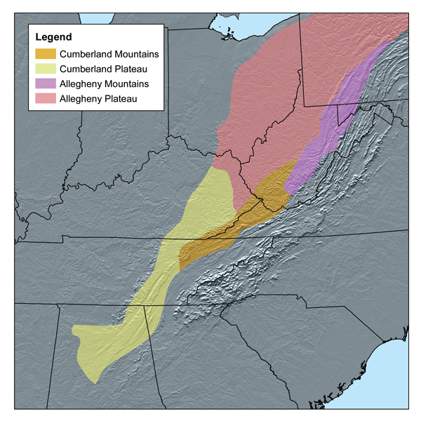
The Cumberland Mountains form a compact, rugged subrange of the larger Appalachian system in the southeastern United States. They extend roughly from northern Tennessee through eastern Kentucky, western Virginia and into southern West Virginia. The range rises as a series of steep ridges and high knobs; its highest point is High Knob near Norton, Virginia, with an elevation of about 4,223 feet (1,287 m). The United States Geological Survey characterizes the Cumberland Mountains as approximately 131 miles (211 km) long and about 20 miles (32 km) wide.
Image gallery
4 Images


Physical features and geology
The range is marked by narrow, north–south trending sandstone ridges, dissected valleys and areas of steep escarpment. Underlying geology includes resistant sandstones and shales along with coal-bearing strata in many valleys and benches. Karst terrain and limestone outcrops are common on the Virginia side, producing numerous caves and springs. The Cumberland Mountains help form part of the drainage divide for several rivers; historic boundaries and watersheds have been defined by features such as the Russell Fork, Pound and Powell rivers and the Cumberland River system.
History, names and human use
The name "Cumberland" was bestowed in reference to the Duke of Cumberland in England. For centuries the range limited east–west travel until natural corridors such as the Cumberland Gap provided practicable passages for Native American travel and later European-American migration. In the 18th and 19th centuries these gaps and valleys became important routes for westward movement. More recently the region supported coal mining, logging and small-scale agriculture; parts of the highlands are now managed for conservation, recreation and sustainable forestry.
Ecologically the Cumberland highlands support mixed hardwood forests and significant biodiversity, including a variety of woodland plants and salamanders typical of the central Appalachian bioregion. Protected lands and state parks conserve examples of the range’s natural communities and offer hiking, hunting, fishing and cave exploration. Cultural ties to Appalachian traditions — music, crafts and rural settlement patterns — remain strong across the region.
Notable places and boundaries
- Highest peak: High Knob (near Norton, Virginia).
- Length and width as reported by the USGS: about 131 miles by 20 miles.
- Major bounding waters: Russell Fork, Pound River, Powell River, Cove Creek, Tackett Creek, the Cumberland River and tributaries such as the Poor Fork and Elkhorn Creek.
- Region includes parts of northern Tennessee, eastern Kentucky, western Virginia and southern West Virginia and contributes to the Kentucky–Virginia boundary in places.
Visitors and researchers may consult regional guides, geological surveys and conservation agencies for maps, trail information and natural history. The range’s mix of steep sandstone ridges, coal-bearing valleys and limestone caves makes it an area of both scenic and scientific interest.
Further resources
- Southeastern region overview
- Appalachian Mountains context
- Tennessee state resources
- Tennessee geography
- West Virginia information
- Virginia: western counties
- Virginia geography
- Kentucky eastern region
- Kentucky information
- Elevation data and maps
- Sea level and elevation notes
- High Knob and Norton, VA
- United States Geological Survey
- Boundary descriptions
- Russell Fork watershed
- Cumberland River system
- Name origin: Duke of Cumberland
- Limestone and karst features
- Cave and karst conservation
For specific maps, park regulations, trail conditions and scientific reports consult state park services, national forest offices and geological survey publications linked above.
Related articles
Author
AlegsaOnline.com Cumberland Mountains Leandro Alegsa
URL: https://en.alegsaonline.com/art/24645
Sources
- tnbirds.org : "Cumberland Mountains in Tennessee"
- mountain-forecast.com : "High Knob – Climbing, Hiking & Mountaineering"
- sherpaguides.com : "Highroad Guide to the Virginia Mountains"
- commons.wikimedia.org : Cumberland Mountains