Border
![]()
The title of this article is ambiguous. For other meanings, see Border (disambiguation).
A border (loanword from Old Polish, cf. Old Slavic, (Old) Polish granica "border", abbreviations: Gr. and Grz. ) is the edge of a space and thus a divider, a dividing line or a dividing surface.
Borders can delimit geographical spaces. These include political or administrative boundaries, economic, customs or property boundaries. Property boundaries are recorded in the real estate cadastre. Spaces can also be blurred, such as landscapes, cultural boundaries or distribution areas that can hardly be defined by line structures in nature.
The boundaries of a volume can be faces, lines, or points, such as the faces, edges, and corners of a cube. Airspace is bounded for the purposes of air traffic; its boundaries include a volume.
An example for limits of one-dimensional spaces is the "upper" and "lower limit" in mathematics (see supremum). Colloquially, this is also called limit, threshold or barrier. Examples for non-geometric spaces are the "usual behaviour" or the privacy.
There are also limits to rights. The general freedom of action from Article 2 paragraph 1 GG (Basic Law of the Federal Republic of Germany) reads:
"Everyone has the right to the free development of his personality, provided that he does not infringe the rights of others or violate the constitutional order or moral law."
Conscience also sets limits to one's own actions.
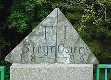
Styria-Lower Austria border on the Wechsel federal road B54
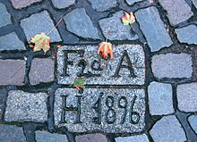
Boundary stone between Altona and Hamburg from 1896, paved in Brigittenstraße, now in the Hamburg-St. Pauli district. (As of 2019)
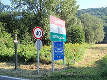
State border Hungary-Austria, B61 between Güns and Rattersdorf
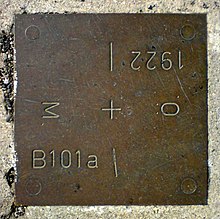
Border marker on the B61, M for Hungary (Hungarian Magyarország)
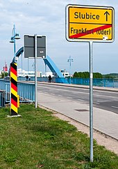
Border post and place name sign at the city bridge Frankfurt (Oder)
_Grenze_auf_Fels_2.jpg)
Bavaria-Tyrol border, rock mark near Kranzhorn
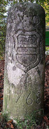
Boundary of 1768 between the Republic (Canton Bern) and the Monarchy (Vorderösterreich, VO) on the Salhöhe (Switzerland)
Word Origin
The word graniza/grænizen/greniz, borrowed from Old Polish in the 12th/13th century, gradually spread from the East German colonisation areas across the German-speaking area and displaced the German word "Mark" (Old High German marka, marcha) for border, border area.
The old native "Mark" is still alive today on the one hand in compounds and derivations such as Markstein (Swiss Marchstein), boundary stone, important, prominent point, common land, total area of a municipality, common land or übermarchen Swiss for "to cross a border, to exaggerate" and on the other hand in names such as Mark Brandenburg and Styria (originally areas on the border with the Slavs).
The etymon "border" is also used today in most Slavic languages and in Romanian: granica (Polish, Croatian, Bosnian), граница/graniza (Russian, Bulgarian), граніца/graniza (Belarusian), граница/granica (Serbian), hranice (Czech) and hranica (Slovak, Upper Sorbian), graniţă (Romanian). It belongs to the Slavic word group ran', e.g. Russian грань/gran' 'borderline, boundary, bounding surface', also 'facet, (edge) surface'.
Origin of state borders
Older political borders between two countries sometimes coincide with the natural obstacles, some of which are difficult to overcome: a mountain range, a sea or estuary, a desert, a virgin forest or a mountainous area. As a rule, these also represent language and cultural borders. Rivers, on the other hand, have only formed state borders since around 1800 (new borders drawn as a result of wars or peace treaties), as they used to be unifying trade routes rather than dividing barriers. Where they are borders today, the valley path is usually used as the boundary line in the boundary treaties, so that the affiliation of islands can also be clearly regulated in this way.
Many later boundaries, such as those between the states of the United States, were set by treaty at specific lines of longitude or latitude. These straight boundaries, which are also found in Africa, are called drawing board boundaries. They did not arise through centuries of evolutionary processes, but are due to acts of will, usually by foreign rulers (colonialism).
A special feature, for example, is the border between the north of the Dutch province of Limburg and Prussia, agreed at the Congress of Vienna in 1815. It was established as that borderline east of the Meuse from which ships sailing on the Meuse could no longer be hit with cannons that were common at the time.
Municipal boundaries also mostly follow the above lines, but also mountain ridges (according to the motto: "as the ball rolls and water flows") and streams.
District boundaries in large cities are usually located on transport routes (roads, railways, paths).
Territorial disputes between many states still exist today due to conflicting territorial claims. Such disputes have frequently led to crises and wars in history.
The expression "phantom border" expresses mental traces of historical borderlines.
See also: Green Border and Blue Border
Search within the encyclopedia