Kentucky
![]()
The title of this article is ambiguous. For other meanings, see Kentucky (disambiguation).
Kentucky (English pronunciation [![]()
![]() kənˈtʰʌki]) (officially the Commonwealth of Kentucky) is a state of the United States of America. The state's name is of Shawnesian or Iroquoian origin, possibly from Wyandotic, meaning "meadow", "floodplain", "corridor". In Senecaic, also an Iroquoian language, the word geda'geh means "in the field." The epithet Bluegrass State, meaning the grassy pastures that bloom blue-green from March to April, is a common euphemism for Kentucky.
kənˈtʰʌki]) (officially the Commonwealth of Kentucky) is a state of the United States of America. The state's name is of Shawnesian or Iroquoian origin, possibly from Wyandotic, meaning "meadow", "floodplain", "corridor". In Senecaic, also an Iroquoian language, the word geda'geh means "in the field." The epithet Bluegrass State, meaning the grassy pastures that bloom blue-green from March to April, is a common euphemism for Kentucky.
Kentucky was first a part of Virginia and joined the United States in 1792 as the 15th state. In the War of Secession, Kentucky initially tried to remain neutral, then residents of the state stood on both sides, such as Abraham Lincoln as President of the Union and Jefferson Davis as President of the Confederacy. Today, however, the United States Census Bureau clearly counts Kentucky as a Southern state.
Along with the states of Virginia, Pennsylvania, and Massachusetts, Kentucky bears the official name "Commonwealth of Kentucky" as opposed to the more common constituent designation as "State."
Geography
Location and delimitation
Kentucky lies between 36°30′ and 39°9′ north latitude and between 81°58′ and 89°34′ west longitude. The state territory thus extends over 225 km in north-south and 610 km in east-west extension and covers 104,659 km².
Kentucky borders the Midwest and South of the USA. It lies between West Virginia, Virginia, Tennessee, Missouri, Illinois, Indiana and Ohio. In the north it is bordered by the Ohio River.
It is the only US state with an exclave that is only surrounded by other states: In western Kentucky's Fulton County, the small strip of Kentucky Bend land formed by the New Madrid earthquake of 1811 lies on the Mississippi River, bordered by the state of Missouri and accessible only through Tennessee.
Regions
There are five main regions: the Cumberland Mountains, the Cumberland Plateau to the southeast, the "Bluegrass Region" to the north, the Pennyroyal Plateau, also called the "Pennyrile" to the south and west, the coalfields to the west, and "Jackson Purchase" to the far west.
The Eastern Coal Fields, a rugged, mountainous region heavily forested and bisected by rivers, has the highest elevations and is located in the River Valley. The highest peak is Black Mountain in Harlan County at 1292 m. The western section of the region includes much of the Daniel Boone National Forest.
The "bustling" central Kentucky, the Bluegrass Region, is located in the northern part of the state. Geologically, it belongs to the oldest part of the state. The limestone-rich soil forms the basis for grain farming and pastures.
Separated from this only by a series of smaller low hills, the Knobs, lies the Mississippi Plateau.
The Western Coal Fields, bounded on the north and northwest by the Ohio River, are already part of the Illinois Basin.
The southwestern part of the state is a low-lying plain called the Jackson Purchase. Here also lies the lowest point of Kentucky in Fulton County in the course of the Mississippi, about 78 m a.s.l. It was named after the later President Andrew Jackson, who in 1818 had initiated the purchase of the land from the Chickasaw as an official agent. The vast alluvial land forms one of the most productive agricultural areas in the country.
Rivers and lakes
Large rivers such as the Ohio or the Mississippi, which also characterize the neighboring states, determine the landscape and borders of Kentucky, with the total river network amounting to about 140,000 km. Other major rivers include the Red and Green Rivers, the Tennessee River, the Cumberland River and Rough River, the Big Sandy River, the Licking and the Kentucky River. Kentucky is also the only state bordered on three sides by rivers: the Mississippi to the west, the Ohio to the north, and the Big Sandy River and Tug Fork to the east. Although the state itself has only three major natural lakes, it does have several reservoirs, some of which were thought to be job-creation schemes during Franklin D. Roosevelt's New Deal policies, such as Lake Barkley on the Cumberland River, named for Vice President Alben W. Barkley, and Dewey Lake on the Big Sandy. The Red River supposedly owes its name to the large amount of blood spilled during fierce Indian fighting at the end of the 18th century.
Nature Conservation
Kentucky features an extensive natural park system. This includes one National Park, Mammoth Cave National Park, two National Recreation Areas, two National Historic Parks, two National Forests, 52 State Parks, 153 square miles of State Forest, and 82 Wildlife Management Areas.
The state is also part of two of the most successful biological reintroduction projects in United States history. In the winter of 1997, the Kentucky Department of Fish and Wildlife Resources began reintroducing wapitis to eastern counties that had been extinct in the area for more than 150 years. In 2009, the project reached its goal of 10,000 animals, making it the largest population east of the Mississippi River.
Kentucky had already successfully reintroduced wild turkeys, which were also extinct here, in the 1950s. Today, more turkeys live here than in any other eastern state.
Structure
- List of counties in Kentucky
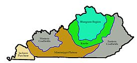
Geographical regions of Kentucky
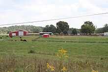
Farm building
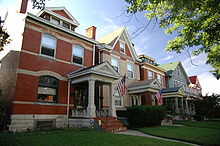
East Row Historic District, Newport
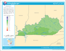
rainfall amounts in Kentucky
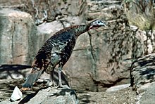
Wild turkey
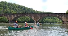
Canoeists on the Cumberland River
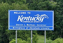
Border sign, Interstate 65
Climate
Located in the southeastern interior of North America, Kentucky has a humid subtropical climate of a temperate nature with cool winters and warm summers. Average temperatures range from 30.9 °C in summer to -4.9 °C in winter with 1168.4 mm of precipitation. The annual mean is around 14 °C across much of the country. Temperature extremes range from -36.7 °C in Cynthiana in 1963 to +45.6 °C in Greensburg in the summer of 1930. In contrast, winter snowpacks of more than 60 cm are common in the foothills of the Appalachians. Kentucky lies in the passage area of several storm systems, some of which are tornadoes, usually between March and September. The most violent storm disasters occurred in the 1890 tornado around Louisville, with at least 76 fatalities, and in the 1974 "Super Outbreak", with 72 fatalities. More recently, a 1997 flood claimed 18 lives, the so-called Super Tuesday tornado outbreak that also affected several other states, with 17 victims in Kentucky alone, and a January 2009 supra-regional ice storm that killed at least 24 people.
Search within the encyclopedia