Mount Roraima: Tepui of the Guiana Highlands
Mount Roraima is a flat-topped sandstone tepui on the Guiana Shield at the Venezuela–Brazil–Guyana border, famed for sheer cliffs, unique endemic life, exploration history and trekking routes.
Overview
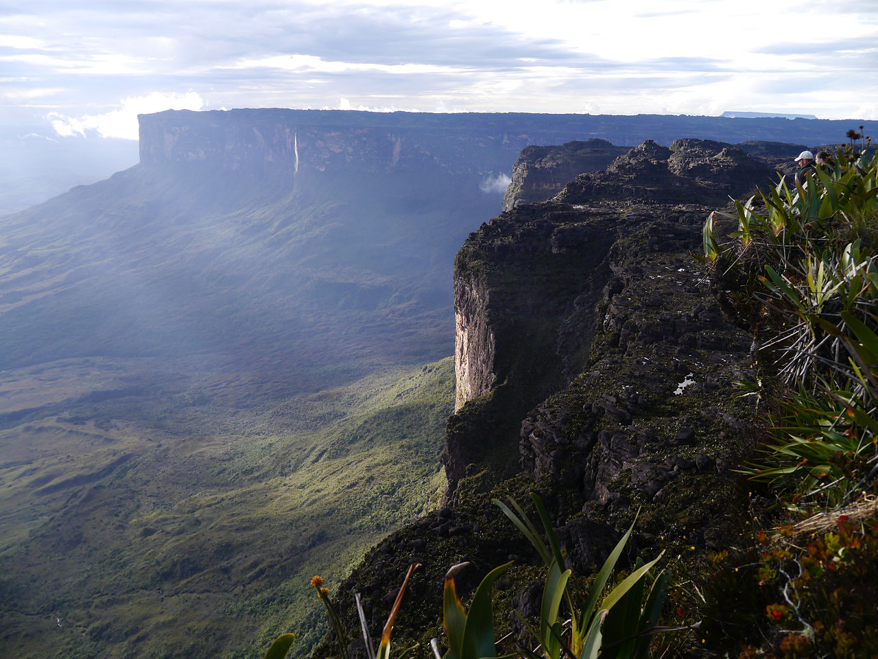
Mount Roraima is one of the most striking table-top mountains—known locally as a tepui—found in the highlands of northern South America. Its roughly 31-square-kilometre summit is bounded on all sides by near-vertical cliffs that rise about 400 metres from the surrounding terrain, creating an isolated plateau that looks like a natural mesa. Roraima is commonly cited as the highest and most famous of the plateaus in the Pakaraima chain.
Image gallery
10 Images


Geology and landscape
Roraima sits on the ancient Guiana Shield, a Precambrian geological formation made of some of the planet’s oldest exposed rocks. The tepui summits formed as erosion-resistant sandstones remained while softer surrounding material wore away, leaving isolated, flat-topped mountains with sheer stone cliffs and deeply weathered surfaces. The summit contains a complex of rock pavements, shallow pools and fissures rather than a single peak, giving it a distinctive, otherworldly appearance.
Natural history and ecology
The isolation of the tabletop has produced high levels of endemism. Because the summit is cut off by steep escarpments, plant and animal communities evolved independently from the surrounding lowlands. Visitors and researchers commonly note carnivorous plants, endemic orchids and bromeliads, small specialized amphibians and arthropods adapted to the cool, humid summit conditions. The plateau’s unique microhabitats—wet depressions, foggy rock faces and nutrient-poor soils—support species assemblages found nowhere else on Earth.
Human history and cultural significance
Local indigenous peoples long knew of Roraima and other tepuis; European awareness dates to accounts relayed to Sir Walter Raleigh during his 1595 expedition, and Roraima appears in early colonial literature after his reports (Sir Walter Raleigh). In the late 19th century the British explorer Sir Everard im Thurn made the first documented ascent to the summit by following a gradual, forested ramp; his 1884 climb opened the plateau to scientific attention. The mountain later inspired popular imagination and literature, most famously influencing Arthur Conan Doyle’s novel "The Lost World".
Borders, names and notable points
The massif straddles modern international boundaries: portions of the plateau lie in present-day Venezuela, Guyana and Brazil. The summit area contains a marker placed by an international commission in 1931 at the point where the three countries meet. The highest summit areas include locations that serve as the highest point of Guyana and of Brazil’s state of Roraima; one summit sector is referred to in some sources as Laberintos del Norte.
Climbing, access and tourism
The steep cliffs make direct climbs from the plateau margins difficult; most visitors reach the top by following the same kind of vegetation-covered ramp first used in the 19th century. Today guided treks approach from the Gran Sabana and surrounding highlands, combining river valleys, savanna trails and a final ascent that traverses mossy forest and rocky steps. Roraima remains a sought-after destination for hikers, naturalists and photographers because of its dramatic scenery and the chance to observe its isolated ecosystems.
Notable facts
- Summit area: approximately 31 square kilometres, a large, flat plateau surrounded by cliffs.
- Cliff height: roughly 400 metres of vertical rock on the plateau’s flanks.
- Geological setting: part of the ancient Guiana Shield and the Pakaraima chain (Pakaraima).
- Historical firsts: reported to Europeans via Raleigh, first recorded modern ascent by Sir Everard im Thurn in 1884.
- Political geography: sits at the frontier of Venezuela, Guyana and Brazil, with a summit marker placed in 1931 and ties to the state of Roraima.
For travelers, scientists and anyone interested in isolated landscapes, Mount Roraima exemplifies the interplay of ancient geology, evolutionary isolation and human exploration. Its combination of dramatic topography, rare plant and animal communities, and cultural resonance keeps it among the best-known tepuis in the world.
Questions and answers
Q: What is Mount Roraima?
A: Mount Roraima is the highest of the Pakaraima chain of plateaus in South America. It has a 31-square-kilometre (12-square-mile) summit area and is bounded on all sides by cliffs rising 400 metres (1,300 ft).
Q: Who first described Mount Roraima to Europeans?
A: The English explorer Sir Walter Raleigh first described it to Europeans during his 1595 expedition. He learned about it from indigenous peoples.
Q: Where does Mount Roraima lie?
A: Mount Roraima lies on the Guiana Shield and is located in Venezuela, Guyana and Brazil. The triple border point where the boundaries of Venezuela, Brazil and British Guiana meet is at 5°12′08″N 60°44′07″W / 5.20222°N 60.73528°W / 5.20222; -60.73528, and the mountain's highest point is called 'Laberintos del Norte'.
Q: What was significant about Sir Everard im Thurn's climb of 18 December 1884?
A: Sir Everard im Thurn's climb of 18 December 1884 was significant because it was the first recorded major table-top to be climbed up using a forested ramp route that would later be used by other climbers as well.
Q: What makes climbing Mount Roraima difficult?
A: Climbing Mount Roraima can be difficult due to its steep sides which make access challenging for climbers.
Q: Is there anything special atop Mount Roraima?
A: Yes, atop Mount Roraima there stands a stone put there by the International Commission in 1931 marking its significance as a triple border point between Venezuela, Brazil and British Guiana.
Q: Why is trekking on Mtn Roriam important in Venezuela?
A: Trekking on Mtn Roriam is important in Venezuela because it one of the most important mountain trekking routes in that country
Related articles
Author
AlegsaOnline.com Mount Roraima: Tepui of the Guiana Highlands Leandro Alegsa
URL: https://en.alegsaonline.com/art/67082
Sources
- books.google.com : British Guiana
- worldcat.org : 253238145