Venezuela: geography, people, culture, history and economy
Overview of Venezuela: its geography, regions, biodiversity, people and languages, historical background, economy centered on oil, agriculture and natural landmarks such as Angel Falls.
Venezuela, officially the República Bolivariana de Venezuela, is a country in northern South America. Its capital and largest city is Caracas. The country’s name and many national symbols honour the independence leader Simón Bolívar. Spanish serves as the primary language of public life (official language, Spanish), while a number of Indigenous languages remain living languages in various communities.
Image gallery
8 Images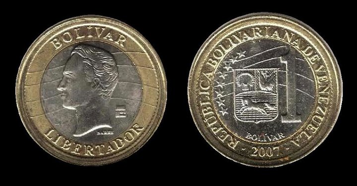


Geography and regions
Venezuela occupies diverse landscapes that include a long Caribbean coastline, scattered islands, extensive lowland plains known as the Llanos, the extensive Orinoco River basin, and highlands forming part of the Andes Mountains. To the southeast the ancient Guiana Shield contains tepuis—table-top mountains that rise abruptly from the forest—and dramatic waterfalls. One of the country’s best-known natural landmarks is Angel Falls, which plunges from a tepui and is noted as the world’s tallest uninterrupted waterfall. Offshore and coastal waters lie in the Caribbean Sea, contributing to a tropical maritime climate along much of the northern coast and a range of climatic zones inland.
Biodiversity and environment
Because of its varied topography and climate zones, Venezuela supports high biodiversity. Tropical rainforests, flooded savannas, montane cloud forests and coastal ecosystems provide habitats for many plant and animal species, including numerous endemics. Large river systems, notably the Orinoco, create broad wetlands and freshwater habitats with ecological and cultural importance. Several national parks and protected areas conserve significant natural regions, although habitats face pressures from development, resource extraction and land-use change.
People, languages and culture
Venezuelan society combines Indigenous, European and African cultural influences. Spanish is the dominant language, while several Indigenous languages of Cariban and Arawakan families and others continue to be spoken; named examples include Warao, Pemon and Wayuu. Religious life has been historically shaped by Christianity, with Roman Catholic traditions especially influential, alongside Protestant communities and continuing Indigenous spiritual practices. Cultural expressions such as music, dance, cuisine and festivals reflect regional variety—from coastal and Llanos traditions to Andean and Amazonian forms.
History and government
Colonial settlement by European powers, independence in the early 19th century and subsequent national development shaped modern Venezuela. The state takes its Bolivarian title in recognition of Simón Bolívar. Over the 20th century the discovery and commercial development of petroleum transformed the economy and international role of the country. Venezuela is organized administratively into states, a capital district and municipalities, and governance has been marked by evolving political movements and institutions.
Economy and natural resources
Venezuela is widely known for its petroleum industry and has been an important global oil producer; petroleum exports have been a central source of revenue and have strongly influenced the national economy and public spending (oil). In addition to hydrocarbons, the country has mineral resources and agricultural production. Traditional crops cultivated over different periods and in various regions include coffee, cocoa, cotton, sugar and tobacco. Economic cycles tied to global commodity prices, efforts to diversify the economy and social policies have all influenced Venezuela’s recent development trajectory.
Transport, infrastructure and regions
Major rivers such as the Orinoco provide inland transport corridors in addition to road and air networks that connect coastal and interior regions. Coastal ports serve maritime trade across the Caribbean, and urban areas are linked by highways and airports. Regional differences—coastal cities, the Llanos, Andean highlands and Amazon-Guiana lowlands—shape local economies, settlement patterns and ways of life.
Tourism, conservation and challenges
Natural attractions such as tepuis and waterfalls, national parks and coastal beaches draw visitors and support local tourism. Conservation efforts focus on preserving habitats, endemic species and Indigenous territories while balancing sustainable development. The country faces social, economic and environmental challenges common to many resource-rich nations, including managing resource revenues, protecting biodiversity, and addressing infrastructure and public-service needs.
- Major regions: Caribbean coast and islands, Llanos, Andean highlands, Guiana Shield.
- Key natural features: Angel Falls, Orinoco River basin, tepuis and Amazonian and coastal ecosystems.
- Languages: Spanish and a range of Indigenous languages (for example Warao, Pemon, Wayuu).
- Economic highlights: petroleum production, agriculture (coffee, cocoa, cotton, sugar, tobacco) and mineral resources.
For general country information and further reading consult an official country profile, regional summaries and thematic resources on environment, culture and travel. Additional material on the Andes region and highland geography appears in specialist treatments of South American mountain ranges (Andes), while natural landmarks such as Angel Falls and marine and coastal environments of the Caribbean Sea are covered in travel and conservation resources. For topics related to Indigenous languages and communities, see referenced linguistic and ethnographic overviews (Indigenous languages). For economic background, consult materials on oil and agricultural commodities such as coffee, cocoa, cotton, sugar and tobacco.

Etymology of the name Venezuela
There are two theories about the origin of the name "Venezuela": Some attribute it to Amerigo Vespucci, who, along with Alonso de Ojeda, led an expedition along the northwestern coast in 1499 (now known as the Gulf of Venezuela). When they reached the Guajira Peninsula, the crew observed the pile dwellings (palafitos) that the Añu had erected over the water. These reminded Vespucci of the city of Venezia (Venice) and as a result the region was named Venezuela, meaning "Little Venice".
On the other hand, the Spanish conquistador and geographer Martín Fernández de Enciso, member of the same team, says in his writing "Suma de Geografía" (1519) that the population of this region inhabited a flat rock and was called "Veneciuela".
Geography
Venezuela has a coastline of about 2800 km. Of the total area, about 39% is forested, 20% consists of meadows and pastures, 4% are fields and arable land.
It borders three countries: to the east Guyana with 743 km border, to the south is Brazil with 1819 km border and to the west Colombia with 2050 km border. The total length of Venezuela's national borders is 4612 kilometers.
Venezuela can be divided into five major geographical areas: the Andes, which extend in a broad east-west arc from the Colombian border along the Caribbean Sea to the east; the Orinoco plains (llanos) in the centre; the Maracaibo lowlands around the brackish water lake there in the northwest; and the highlands of Guiana in the southeast. In addition, there are the Venezuelan Caribbean islands. Venezuela is the sixth largest country in South America. It is very diverse in landscape; the strongest contrasts are the dune landscapes at the Isthmus of Coro and the swamps of the Delta Amacuro, respectively the snow-covered mountains of the Cordillera de Mérida and the wide plains in the heart of the country.
Nature
Venezuela is considered one of the world's megadiverse countries, with a particularly high level of biodiversity, a large number of endemic species, genera and families of plants and animals, and diverse ecosystems.
Venezuela today has 43 national parks (see List of National Parks in Venezuela) and 36 natural monuments. 62.9 percent (2007) of the country's land area is designated as protected. Venezuela thus has the highest percentage of nature reserves in North and South America (compared to Brazil, for example, with 18.5 percent).
The country can be divided into the following four major natural areas:
Andes
The peaks of the Venezuelan Andes reach up to almost 5000 m above sea level. A large part of Venezuela's population lives in the fertile valleys between the mountains, and industry and agriculture are also concentrated here. The rugged mountain ranges on the Colombian border, on the other hand, are the most sparsely populated part of this region.
South of Lake Maracaibo, in the Andean arc, rises the highest mountain in Venezuela, Pico Bolívar, at 4981 m. Some peaks in this region are covered with snow all year round. A wide valley separates this mountain range from another one that follows the coast. The capital Caracas is also located in this valley. This relatively small area is the most densely populated region of the country. It is here that the most intensive agriculture is practiced and the transportation network is the best developed.
Orinoco Plain
South of the mountains stretch the great plains of the llanos. They extend from the Caribbean coast in the east to the Colombian border. The Orinoco forms the southern border. The island of Margarita is located off the mainland.
In addition to the grasslands, this region also includes swamplands in the Orinoco Delta and on the Colombian border. Elevations in the llanos do not exceed the 200-meter mark.
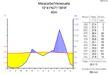
The Maracaibo Lowlands
The Maracaibo lowlands are surrounded by mountain ranges, except in the north. Here it borders on the Caribbean Sea. This region is very flat and rises only slightly towards the surrounding mountains. Lake Maracaibo, which covers 13,000 km² and is up to 50 m deep, occupies much of the lower lying areas. It is connected to the Gulf of Venezuela by the Canal de San Carlos strait, which is about 75 km long. Beneath the eastern shore of the lake lie Venezuela's richest petroleum reserves.
The largest city in the region is the port city of Maracaibo on the lake of the same name.
Guiana Highlands
The Guiana highlands rise southeast of the Orinoco and are one of the oldest landscapes in South America. This highland, characterized by plateaus and tributaries of the Orinoco, occupies more than half of Venezuela's land area. The most striking formation of this region is the Gran Sabana, a large, heavily eroded plateau. Over millions of years, the sandstone masses were eroded away, leaving rugged valleys and massive mesas (tepuis). Their age is estimated at 70 million years. The 115 different tepuis in this area are characterized by a unique and peculiar flora and fauna on their plateaus, because due to the isolation many endemic species have developed.
The highest waterfalls in the world, such as Salto Kukenan and the highest waterfall in the world, Salto Ángel, with a drop of 978 meters, fall from the mesas. It is also one of the most famous sights of Canaima National Park, which has been declared a World Heritage Site by UNESCO.
Rivers and hydrography
With a length of 2574 km, the Orinoco is the largest and most important of the country's thousand rivers. As recently as 1958, it had no bridge crossing its entire length. It rises in the border region between Venezuela and Brazil at one of the largest watersheds in Latin America. The water level of the Orinoco varies considerably depending on the season. The highest levels are measured in August and exceed the lows of March and April by more than seven meters. Most of the riverbed has only a slight gradient.
Below the headwaters, a globally rare geographical phenomenon can be found: the river splits into two arms, a so-called bifurcation. The Brazo Casiquiare (literally: Casiquiare arm), a natural channel, connects the two independent river systems of the Orinoco and the Amazon. In this process, one-third of the water flows into the Amazon via the Rio Negro (Amazon), while the rest continues to flow into the main Orinoco channel. This passage allows shallow draft vessels to cross from the Orinoco into the Amazon river system. As a result, the vast areas between the Orinoco, Amazon and Atlantic form an island.
Most of the rivers that rise in the northern mountains flow in a southeasterly direction to the Río Apure, a tributary of the Orinoco. The Apure flows through the llanos in an easterly direction. There are no significant headwaters in the low rainfall area south of the Apure.
Another important river is the Río Caroní, which is characterized above all by its high flow velocity. It rises in the highlands of Guyana and flows into the Orinoco at the height of Ciudad Guayana. The Caroní is particularly suitable for the construction of hydroelectric power plants and thus contributes significantly to Venezuela's energy budget.
Climate
|
| ||
|
|
|
|
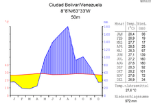
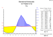
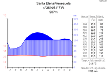
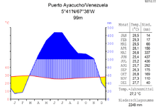
Although Venezuela is located in the middle of the tropical climate zone, all types of climates from tropical humid to alpine are found, depending on the altitude, topography and the direction and intensity of the prevailing winds. Seasonal variations are distinguished less by temperature than by varying amounts of precipitation. In most of the country there is a rainy season from May to October.
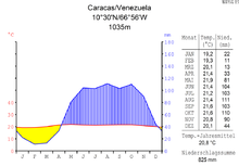
The country is divided into four temperature zones, which can be largely attributed to the respective altitude: The tropical zone (below 800 m) has average annual temperatures between 26 °C and 28 °C. The temperate zone, with average temperatures of 12 °C to 25 °C, extends between 800 and 2000 m above sea level. This is where most of Venezuela's cities are located, including the capital Caracas. Colder conditions, with temperatures ranging from 9°C to 11°C, are found in the cool zone between 2000 and 3000 meters. Pastureland dominates the landscape in the high mountains (from 3000 m above sea level) and above 4000 m there are permanent snowfields. Here, the annual average temperatures are below 8 °C.
Annual rainfall ranges from 430 mm in the semi-arid lowlands and plains of the western part of the Caribbean coast to about 1000 mm in the Orinoco Triangle. In the mountainous regions, rainfall varies considerably, as less rain falls in the depressions than on the mountain flanks, which are exposed to the northeast winds.
Caracas receives 750 mm of precipitation from June to August, half of its annual rainfall.
The average maximum temperature in the country is between 30 °C and 31 °C. However, the temperature can deviate from this average value in individual places, so it is not uncommon for maximum temperatures to reach around 40 °C. The average minimum temperature ranges between 7 °C and 12 °C, depending on the month, with temperatures rarely falling below 10 °C from April to November. From July to January it sometimes rains for almost half a month, in the other months there are only one to seven rainy days per month.
Time zone
In 1964, the time zone in Venezuela was realigned according to the 60th degree of longitude (UTC-4, previously UTC-4:30). On 9 December 2007, the clock was set back by half an hour, and the time zone UTC-4:30 (VST - Venezuelan Standard Time) applied again. Since 1 May 2016, UTC-4 time has been in effect again, partly in the hope of reducing electricity consumption.
Major cities
See also: List of cities in Venezuela
The capital Caracas is the second largest city in the country and the largest metropolitan area in the country.
| Major cities in Venezuela | |
| City | Inhabitants 2017 |
| 2.198.200 | |
| 2.084.500 | |
| Valencia | 1.557.000 |
| Barquisimeto | 1.070.600 |
| Ciudad Guiana | 865.200 |
| Maturín | 496.900 |
| Maracay | 457.200 |
| Barcelona | 441.800 |


Questions and answers
Q: What is the official name of Venezuela?
A: The official name of Venezuela is República Bolivariana de Venezuela (Bolivarian Republic of Venezuela).
Q: What is the capital city of Venezuela?
A: The capital city of Venezuela is Caracas.
Q: What are some geographical features in Venezuela?
A: Geographical features in Venezuela include islands in the Caribbean Sea, coastal areas, highlands, and parts of the Andes Mountains.
Q: What is a famous landmark located in Venezuela?
A: A famous landmark located in Venezuela is Angel Falls, which is the world's tallest waterfall located in the Bolivar state.
Q: What resources does Venezuela have an abundance of?
A:Venezuela has an abundance of oil, gasoline, minerals, and fossil fuels.
Q: What are some industries that contribute to Venezuelan economy?
A: Industries that contribute to Venezuelan economy include oil production, cotton production, cocoa production, sugar production, coffee production and tobacco production.
Q:What languages are spoken by people living in Venezeula?
A: Languages spoken by people living in Venezeula include Spanish as well as Carib Guahibo Warao Wayuu Pemon and Piaroa.
Related articles
Author
AlegsaOnline.com Venezuela: geography, people, culture, history and economy Leandro Alegsa
URL: https://en.alegsaonline.com/art/104552
Sources
- imf.org : "Venezuela"
- ine.gov.ve : "Gini coefficient for the Bolivarian Republic of Venezuela"
- hdrstats.undp.org : "Human Development indicator for the Bolivarian Republic of Venezuela"
- eluniversal.com : "BCV decidió retirar la expresión "soberano" del bolívar actual"
- currency-iso.org : "ISO 4217 amendment number 168" · web.archive.org
- ine.gob.ve : "Para el 30 de octubre de 2011, 28.946.101 Total preliminar de personas en Venezuela"
- wikidata.org : wikidata.org/wiki/Q717
- authority.bibsys.no : 15010050
- bncatalogo.cl : 000017330
- catalogo.bne.es : XX450595
- catalogue.bnf.fr : cb119457375
- data.bnf.fr : (data)
- ci.nii.ac.jp : DA1484418X
- d-nb.info : 4062512-6