South America
South America
.svg.png)
![]()
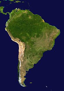
South America is the southern part of the American double continent, has a population of over 428 million people and with an area of 17,843,000 km² is the fourth largest continental land area on earth.
South America is surrounded by the Atlantic Ocean to the east and the Pacific Ocean to the west. The island of Tierra del Fuego at the southern tip of South America is separated from the neighbouring continent of Antarctica by the Drake Strait. Just south of Tierra del Fuego is Cape Horn, where the Atlantic and Pacific Oceans meet. To the north, there is a connection to North America via the isthmus of Panama.

Satellite image of South America
Geography
The South American subcontinent can be divided into three major areas:
- The Andes as high mountains on the western side of the continent
- Three river plains east of the Andes
- Three mountain countries east of the Andes
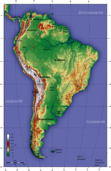
On the west coast lies the Andes, the longest overseas mountain range in the world. The high mountains stretch along the Pacific Ocean over 7500 km from Venezuela to the southern tip of Patagonia. The highest mountain of the Andes, at the same time the highest mountain of South America and the highest mountain outside Asia, is the Aconcagua with 6961 m height. It lies on the border between Argentina and Chile. The Laguna del Carbón, at 105 metres below sea level the lowest point in South America, is located in the San Julián Basin in Patagonia. Cape Horn is usually referred to as the southernmost point of South America.
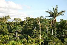
The largest river plain is the Amazon Basin (Amazonia), an equatorial rainforest lowland drained by the Amazon River with its approximately 10,000 tributaries. Flowing eastward from the Andes across the entire continent, the Amazon is the longest river in South America at about 6448 km and the most water-rich river on earth. To the north lies the Orinoco Plain, bounded to the Amazon basin by the mountainous lands of Guiana to the south and the Venezuelan coastal mountains to the north. Another flood plain lies in the south of the continent, where the river system of Río Paraguay and Río Paraná, coming from the Pantanal in the north, merges in the south into a subtropical alluvial landscape.
The mountainous countries are the Mountainous Country of Guyana, the Brazilian Mountainous Country and the Eastern Patagonian Mountainous Country. The Mountain Country of Guyana is divided into the Rainforest Mountain Country of Southern Venezuela, the Central Highlands of Guyana, and the Eastern Mountain Country of Guyana, extending between the Orinoco and Amazon river plains with a maximum elevation of up to 2800 m. The Central Brazilian Highlands dominate central South America, extending to the coast of Brazil and the pampas of Argentina to the south, respectively. The Eastern Patagonian Mountains rise to the east of the Andes at the southern tip of South America.
For details see Physical Geography of South America
See also: List of South American islands
Geology and geomorphology
The Pacific side of South America is characterized by an active continental margin in the form of a subduction zone, while the Atlantic continental side is plate tectonically passive. The eastern mountainous lands of South America have a large Precambrian basement, which may be overlain by sandstones. The basin structures of the current plains are dominated by Tertiary and Quaternary sediments. To the south, the Patagonian Platform forms the basement of the Patagonian Mountains. The Andean orogen consists largely of volcanic-sedimentary blanket strata, post-Precambrian sedimentary basins, and Middle and Late Precambrian basement mountains. (after ZEIL 1986) The Andean regions are characterized by volcanism and earthquakes due to their location at the active continental margin.
South America was once part of the primeval continent Gondwana. Clues to this are the exact fit to Africa, substantial basalt deposits that formed during rifting on today's east coast, the strike directions of sandstones, and signs of Permo-Carboniferous glaciation. Southern South America is characterized by glacial series of Quaternary glaciations. Geomorphological features include glacial lakes, moraines, and glacial drainage forms.
South America has economically important deposits of raw materials and minerals, ores, saltpetre, oil, coal and gold are mined.
Climate
The climate of South America is extremely complex. Year-round climatic influences include the cold Humboldt Current on the west coast of Peru, the Intertropical Convergence Zone (ITCZ), the formation of tropical cyclones at the edge of the subtropical high pressure area, and the trade winds. The cold Humboldt Sea Current causes a cooling of the sea surface off the coast of Peru and northern Chile, leading to the formation of coastal deserts. This phenomenon is due to the fact that the cooled air leads to a constant inversion, thus a stable area of high pressure that does not allow convection and therefore precipitation. The effect is extensive desert regions on the coasts. The equatorial tropical situation causes the formation of an inner-tropical convection zone over the central Amazon region in the southern winter and leads to heavy precipitation. In summer it shifts further south, thus the inner tropics are characterized by year-round precipitation. Also in summer, a continental heat low forms, which is very precipitous. The southern marginal tropics are thus characterized by (southern) summer precipitation. The northern marginal tropics are characterized by trade wind congestion in the east (year-round high precipitation) and by cool ocean waters on the coast in the north (very low precipitation).
The south trade winds on the east coast lead to increased precipitation in the coastal regions, characterised in the southern summer by the formation of monsoonal easterly winds and in the southern winter by stagnant precipitation in the coastal regions. The stable high-pressure system at the western edge of South America in interaction with the cold air masses of the southern polar regions leads to the formation of extratropical cyclones off the coast of western Patagonia. The cyclonic fronts vary in their location in the southern summer and winter. The northward shift in the southern winter leads to periodic winter precipitation in the Greater South of Chile (jungle Chile) and sporadic winter precipitation in the Lesser South of Chile. In turn, the shift of the cyclonic fronts in the southern summer (influenced by the changed position of the ITCZ) leads to a pronounced summer drought in all of southern Chile, except Patagonia. The cyclonic fronts form heavy barrage precipitation on the Andean windward side of the Patagonian mountains, which can be described as hypermaritime. These stagnant precipitations on the west side cause the Andean leeward side of Patagonia to be characterized by drought.
The Andes themselves have a further climatic subdivision in the vertical dimension. Generally speaking, five altitudinal levels can be distinguished: Tierra Caliente (Warm Earth, up to 1000 m), Tierra Templada (Temperate Earth, up to 2000 m), Tierra Fria (Cold Earth, up to 3500 m, cultivation limit and frost line), Tierra Helada (Icy Earth, up to 4500 m, snow line), and Tierra Glacial (Glacial Earth, up to 6000 m, anecumene).
Furthermore, glaciations are present in the Andes. In Peru, the largest intra-tropical glaciations in the world are found. In Patagonia there is extensive inland glaciation and tongue glaciers reaching down to sea level.
A significant climatic phenomenon for the South American west coast is El Niño, because although it is a purely oceanic phenomenon in origin, it is mainly its climatic consequences that are noticed. The cold water currents off South America break off and warm water accumulates off the South American coast. As a climatic consequence, the normally prevailing stable high-pressure situation is thus cancelled and a reversal of the Walker circulation occurs, with severe effects due to heavy precipitation.

Topography

South American Jungle
Wildlife
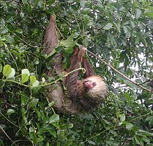
Zoogeographically, South America belongs to the Neotropical region, which also includes Central America and the West Indies. The South American continent was isolated from the other continents during most of the Earth's modern era. At that time, unique mammalian forms emerged, some of which are still characteristic of South America today. These include various marsupials, the armadillos, anteaters and sloths. The New World monkeys and guinea pig relatives also arrived on the continent very early (presumably from Africa) as island jumpers, giving rise to a great abundance of native species. The rest of the present-day mammalian fauna of the Neotropical region, however, consists largely of groups that migrated from North America during the Great American Faunal Exchange about 3 million years ago. At that time, even-toed ungulates (deer, camels, umbilical pigs), odd-toed ungulates (tapirs), hares, predators (cats, dogs, martens, bears, small bears), shrews, and the rodent families of New World mice and squirrels migrated from North America to South America. In addition, the proboscideans and horses also arrived in South America at that time, but they disappeared again in the course of the Quaternary extinction wave at the end of the Pleistocene. With them, numerous other large animals also disappeared, such as the giant sloths, glyptodonts, toxodonts, Macrauchenia and the saber-toothed cat Smilodon. If South America was a continent of giants until 12,000 years ago, today the Central American tapir is the continent's largest land mammal. Jaguar and spectacled bear represent the largest land predators.

Hoffmann's Two-Fingered Sloth
Questions and Answers
Q: What is the continent south of North America?
A: South America.
Q: How many continents are there in total?
A: Seven.
Q: What is the fourth largest continent?
A: South America.
Q: How many countries make up South America?
A: Fourteen.
Q: Which countries are included in South America?
A: Argentina, Bolivia, Brazil, Chile, Colombia, Ecuador, Falkland Islands (United Kingdom), French Guiana (France), Guyana, Paraguay, Peru, Suriname, Uruguay and Venezuela.
Q: How is Central America connected to South America?
A: At the boundary of Panama.
Q: Is all of Panama considered part of North or Central America?
A: North America alone.
Search within the encyclopedia