Hook echo: radar signature of rotating thunderstorms and tornado risk
Hook echo — a curved radar reflectivity pattern from precipitation and debris wrapped into a storm's rotating updraft; often indicates elevated tornado risk but is assessed with Doppler and spotter reports.
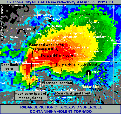
Hook echo describes a curved, hook-like pattern seen on weather radar reflectivity images associated with some rotating thunderstorms. The feature typically appears as a comma- or hook-shaped appendage on the rear flank of the storm and is produced when precipitation and solid hydrometeors wrap around the storm’s rotating updraft.
Image gallery
4 Images


How the signature develops
The curved reflectivity pattern forms when bands of rain, hail, or lofted debris are drawn into a storm’s circulation and concentrate in a narrow, curved region. In strong rotating thunderstorms, commonly referred to as supercell thunderstorms, this wrapping produces a compact area of enhanced radar returns that projects outward from the main precipitation shield. On conventional reflectivity displays the shape resembles a hook or question mark, which is why meteorologists refer to it as a hook echo.
Connection to tornadogenesis
Because the hook-like feature marks precipitation spiraling around a mesocyclone, its presence is often correlated with the formation of a tornado or with conditions that make a tornado more likely. When radar operators detect a pronounced hook echo, forecasters may treat it as strong evidence of low-level rotation that could be producing ground-level damage.
Operational response
When radar shows a convincing hook echo combined with other indicators (such as Doppler velocity signatures or eyewitness reports), the National Weather Service can issue a tornado warning to alert people in the affected area. Modern warnings rely on multiple data sources rather than a single reflectivity pattern.
Limitations and context
- Not all tornadoes produce a clear hook echo; small or rain-wrapped tornadoes and storms observed at long range may not show the feature because of radar beam geometry or resolution limits.
- A hook-like echo can sometimes be a false alarm if non-rotational processes produce a similar reflectivity pattern or if debris returns are absent.
- Forecasters combine reflectivity with Doppler velocity fields, spotter reports, and other observations to distinguish between true tornadic activity and look-alike echoes.
In summary, a hook echo is a distinctive radar reflectivity pattern that often indicates precipitation and debris wrapping into a storm’s rotating core. It remains a valuable visual cue in severe-storm warning operations but is interpreted alongside other sources of data to assess tornadic risk.
Related articles
Author
AlegsaOnline.com Hook echo: radar signature of rotating thunderstorms and tornado risk Leandro Alegsa
URL: https://en.alegsaonline.com/art/45037
Sources
- glossary.ametsoc.org : Glossary of Meteorology
- isws.illinois.edu : "ISWS is Pioneer in Tracking Tornadoes by Radar"