
Boston Mountains: high, rugged core of the Ozark Plateau
Overview of the Boston Mountains — geology, topography, rivers, ecology, climate, human use and conservation of the high, deeply dissected plateau in northern Arkansas and eastern Oklahoma.
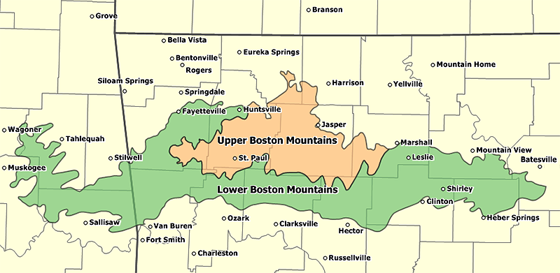
The Boston Mountains form the highest and most rugged portion of the Ozark Plateau, occupying a broad area of northern Arkansas and extending into eastern Oklahoma. Rather than a single continuous ridge, the region is best described as a high, deeply dissected plateau: broad upland summits and ridgelines are broken by steep-sided valleys and narrow stream hollows. In eastern Oklahoma the same physiographic block is commonly called the Cookson Hills.
Image gallery
9 Images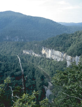


Geology and structure
The Boston Mountains are underlain by a largely intact stack of Paleozoic sedimentary rocks. Near the surface the highest ridges and caps are commonly composed of Pennsylvanian sandstones and interbedded shales that resist erosion. Beneath these lie Mississippian limestones and, at greater depth, Ordovician dolomites and other carbonate units. The pattern of relatively hard sandstones over softer carbonate rocks encourages the development of steep escarpments, cliffs and narrow, deeply incised stream valleys as the softer layers weather and rivers cut downward.
Karst features—springs, small caves and localized solutional pits—are often associated with the carbonate layers, especially where overlying shales and sandstones have been breached by erosion. The regional stratigraphy and structural setting also influence groundwater flow and the locations of springs that sustain many headwater streams.
Topography and notable high points
The Boston Mountains are the highest and most rugged part of the Ozarks. Elevations commonly reach about 2,500 to 2,600 feet at the highest summits, with the highest point in the range reported near 2,578 feet. Valleys commonly drop from ridgelines several hundred feet and in places more than a thousand feet; local relief is therefore significant compared with surrounding uplands. Turner Ward Knob, in western Newton County, Arkansas, is a well-known named summit and is among the taller peaks in the area, and other knolls and knobs punctuate the upland plateaus.
Rivers, watersheds and hydrology
The Boston Mountains are an important headwater region. Streams rise on the slopes and flow outward in many directions, feeding several major river systems of the interior South. Principal rivers and creeks with headwaters in the Boston Mountains include the White River and its tributaries, the Buffalo River, the Kings River and War Eagle Creek. Other streams originating in the highlands include the Illinois River and its tributaries, the Mulberry River, Lee Creek, Frog Bayou, Big Piney Creek, Illinois Bayou and branches of the Little Red River. These streams have carved the characteristic valleys and formed bluffs, springs and riffle-pool sequences valued for wildlife and recreation.
Drainage patterns reflect the plateau structure: many creeks run in narrow channels through resistant rock, and springs often mark places where permeable and impermeable layers intersect the landscape. To the south, the lower Arkansas River valley separates the Boston Mountains from the Ouachita Mountains.
Ecology and vegetation
Vegetation across the Boston Mountains is dominated by mixed hardwood forests. Common tree groups include oaks and hickories on drier slopes, and shortleaf pine and mixed pine-hardwood stands on flatter or more fire-influenced sites. Riparian corridors support sycamore, maple, river birch and other moisture-loving species. The complex topography and variety of microhabitats support diverse wildlife, including numerous bird species, mammals and aquatic communities adapted to clear, cool headwater streams.
Soils are generally shallow, stony and well drained on steep slopes, while deeper alluvial soils occur in valley bottoms. These soil conditions limit extensive row-crop agriculture and favor forestry, pasture and local-scale farming in gentler hollows.
Climate and environmental processes
The Boston Mountains experience a temperate climate with distinct seasons. Precipitation is sufficient to maintain perennial streams and supports the forests that cloak much of the uplands. Weathering, mass wasting on steep slopes, and stream incision continue to shape the landscape; periodic high flows in headwater streams can be important agents of erosion and sediment transport.
Human history, land use and communities
Human use of the Boston Mountains includes long-standing indigenous presence followed by European-American settlement, timber harvest, and small-scale farming. Logging and timber management have shaped much of the recent vegetative history, and many communities are small towns and unincorporated settlements situated in valley hollows and at road junctions. Because steep slopes and thin soils limit large-scale agriculture, land use tends to focus on forestry, livestock in gentler areas, and recreation.
Conservation and recreation
Large tracts of the Boston Mountains are managed for multiple uses, including national forest lands, state parks and protected river corridors. The scenic valleys, clear headwater streams and rugged ridges attract hikers, anglers, paddlers and hunters. Protected areas and designated river units emphasize watershed protection, recreation and habitat conservation, and several rivers originating in the Boston Mountains are nationally or state-recognized for their scenic and ecological values.
Access and notable sites
Access to the Boston Mountains is provided by a network of state and county roads, scenic byways and trail systems. Towns on the margins of the highlands serve as gateways for outdoor recreation and local tourism. Visitors commonly travel to well-known river corridors, overlooks and trailheads to experience the region’s topographic variety and clear streams.
Resources and further reading
- Overview of the Boston Mountains region
- Northern Arkansas regional information
- State-level resources for Arkansas
- Eastern Oklahoma landscape summaries
- Oklahoma state information
- Cookson Hills local name and references
- Regional rock types and stratigraphy
- Pennsylvanian period rock descriptions
- Sandstone and shale in upland caps
- Shale distribution and weathering
- Mississippian limestones and karst features
- Ordovician formations in the region
- Dolomite and carbonate rock notes
- Location within the larger Ozark Plateau
- Turner Ward Knob and named summits
- Rivers originating in the Boston Mountains
- Streams and headwaters detail
- The White River watershed
- Arkansas River valley and its separating role
- Ouachita Mountains and neighboring systems
Related articles
Author
AlegsaOnline.com Boston Mountains: high, rugged core of the Ozark Plateau Leandro Alegsa
URL: https://en.alegsaonline.com/art/13220