Nicobar Islands: geography, peoples, environment and administration
Island chain in the eastern Indian Ocean administered by India; known for indigenous Nicobarese and Shompen communities, tropical biodiversity, protected areas, and major impacts from the 2004 tsunami.
Overview
The Nicobar Islands form an archipelago in the eastern Indian Ocean and are part of the Republic of India. The group comprises about 22 larger islands and numerous smaller islets with a combined land area of roughly 1,841 km². The largest island is Great Nicobar; the highest point is Mount Thullier (about 642 m). The archipelago, together with the Andaman Islands, separates the Bay of Bengal from the Andaman Sea and lies several hundred kilometres northwest of Sumatra (Indonesia).
Image gallery
4 Images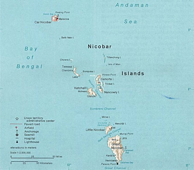


Geography and island groups
The islands are grouped into northern, central and southern clusters. The northern group includes Car Nicobar and small adjacent islets. The central group contains islands such as Katchal, Camorta, Nancowry, Teressa and Trinket, and several uninhabited isles. The southern group is dominated by Great Nicobar and Little Nicobar and includes many smaller islets and wildlife reserves. The Ten Degree Channel separates the Nicobars from the Andaman Islands, and the chain lies roughly 1,300 km southeast of the Indian mainland when measured across the Bay of Bengal.
Environment and biodiversity
The Nicobars are noted for humid tropical rainforests, coastal mangroves and coral reefs. Many islands show dense evergreen forest in the interior and littoral vegetation along the coasts. These habitats support a rich assemblage of birds, reptiles, mammals and marine life, including sea turtles and reef fishes. Several islands or parts of islands have formal protection as wildlife sanctuaries and reserve areas, and portions of Great Nicobar are included within a larger biosphere and conservation framework to protect endemic species and migratory visitors.
People, languages and culture
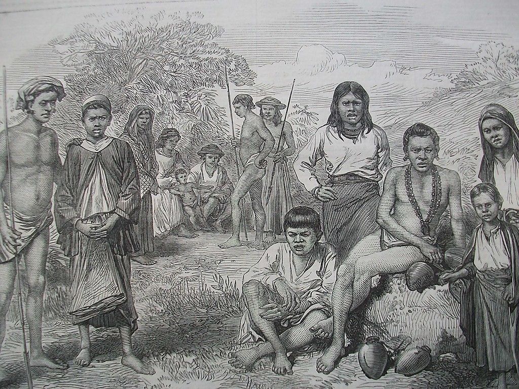
Indigenous communities are central to the islands' human geography. The Nicobarese people, who speak languages belonging to the Austroasiatic family, are the dominant indigenous group; the Shompen are a smaller, more isolated community with distinct subsistence patterns. Historically the islands were sparsely populated, and over time settlers from the Indian mainland and Sri Lanka have also arrived. Official records and studies provide demographic summaries; for general figures and governance-related data see available population sources.
Economy and local livelihoods
Traditional economies on the Nicobars rely on small-scale agriculture, coconut cultivation, fishing, and the harvesting of forest products. Local markets, handicrafts and inter-island trade sustain many settlements. Economic development is constrained by remoteness, the need to protect sensitive ecosystems and the rights of indigenous communities; infrastructure is therefore limited compared with mainland regions, and most long-distance travel is by sea or limited air connections to the territorial capital.
Administration and access
Administratively the Nicobar Islands are part of the Union Territory of the Andaman and Nicobar Islands, a federally administered territory of India. The territorial capital is at Port Blair on South Andaman. For administrative purposes the Nicobars form the Nicobar district; see Nicobar district for district-level arrangements. Because of the islands' cultural sensitivity and ecological importance, the Government regulates entry: travel to many islands requires permits and access by foreign nationals is generally restricted under current policy reflecting conservation and social protection priorities described for the Union territory.
History, geology and notable events
The Nicobars have long been inhabited and visited by seafaring peoples of South and Southeast Asia and later encountered by European navigators. They were incorporated into colonial administrative systems during the 19th and early 20th centuries and were affected by global events in the 20th century. The islands lie in a tectonically active region where plate interactions have produced earthquakes and tsunamis; the 2004 Indian Ocean earthquake and tsunami caused major coastal change, damage to settlements and shifts in shoreline and infrastructure, including at Indira Point on Great Nicobar.
Conservation, threats and research
Conservation concerns on the Nicobars include habitat loss, invasive species, overharvesting of marine resources and vulnerability to coastal hazards and sea-level change. Protected areas, wildlife sanctuaries and locally managed conservation measures aim to balance livelihood needs with ecosystem protection. The islands are also a focus for research into island biogeography, tropical ecology, disaster recovery and the cultural resilience of small island communities. Regional context and broader geographic references can be found in overview maps and resources addressing the Bay of Bengal and neighbouring regional maps, the nearby Andaman Islands, and the neighbouring maritime states such as Indonesia.
Practical notes
Visitors should be aware that entry is regulated, that facilities are limited, and that travel may require coordination with territorial authorities. Conservation rules and local customs are strictly observed in many communities to protect fragile ecosystems and cultural traditions. Researchers, aid agencies and travellers typically coordinate with Indian administrative authorities and local leaders to ensure compliance with permit systems and community expectations.
Related articles
Author
AlegsaOnline.com Nicobar Islands: geography, peoples, environment and administration Leandro Alegsa
URL: https://en.alegsaonline.com/art/69999